Items Similar to Original Antique Map of the Bay and Rocks of Petatlan, Mexico, 1749


Want more images or videos?
Request additional images or videos from the seller
1 of 5
Original Antique Map of the Bay and Rocks of Petatlan, Mexico, 1749
$340.26
$425.3220% Off
£255.04
£318.8120% Off
€288
€36020% Off
CA$467.46
CA$584.3220% Off
A$521.87
A$652.3420% Off
CHF 273.45
CHF 341.8220% Off
MX$6,388.22
MX$7,985.2820% Off
NOK 3,472.86
NOK 4,341.0720% Off
SEK 3,274.46
SEK 4,093.0820% Off
DKK 2,192.36
DKK 2,740.4520% Off
Shipping
Retrieving quote...The 1stDibs Promise:
Authenticity Guarantee,
Money-Back Guarantee,
24-Hour Cancellation
About the Item
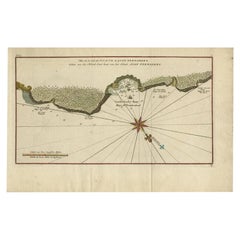
Antique map titled 'Baye et Rochers de Petaplan (..) - De Baay en de Rotsen van Petaplan (..)'.
Original antique map of the bay and rocks of Petatlan, Mexico. This map originates from 'Reize rondsom de Werreld (..)' by George Anson, published 1749.
Artists and Engravers: Admiral of the Fleet George Anson, 1st Baron Anson, PC, FRS (23 April 1697 – 6 June 1762) was a Royal Navy officer.
- Dimensions:Height: 10.75 in (27.3 cm)Width: 16.34 in (41.5 cm)Depth: 0 in (0.02 mm)
- Materials and Techniques:
- Period:1740-1749
- Date of Manufacture:1749
- Condition:Condition: Good, given age. Original folds as issued. General age-related toning and/or occasional minor defects from handling. Please study image carefully.
- Seller Location:Langweer, NL
- Reference Number:Seller: PCT-61587 1stDibs: LU3054326922102
About the Seller
5.0
Recognized Seller
These prestigious sellers are industry leaders and represent the highest echelon for item quality and design.
Platinum Seller
Premium sellers with a 4.7+ rating and 24-hour response times
Established in 2009
1stDibs seller since 2017
2,511 sales on 1stDibs
Typical response time: <1 hour
- ShippingRetrieving quote...Shipping from: Langweer, Netherlands
- Return Policy
Authenticity Guarantee
In the unlikely event there’s an issue with an item’s authenticity, contact us within 1 year for a full refund. DetailsMoney-Back Guarantee
If your item is not as described, is damaged in transit, or does not arrive, contact us within 7 days for a full refund. Details24-Hour Cancellation
You have a 24-hour grace period in which to reconsider your purchase, with no questions asked.Vetted Professional Sellers
Our world-class sellers must adhere to strict standards for service and quality, maintaining the integrity of our listings.Price-Match Guarantee
If you find that a seller listed the same item for a lower price elsewhere, we’ll match it.Trusted Global Delivery
Our best-in-class carrier network provides specialized shipping options worldwide, including custom delivery.More From This Seller
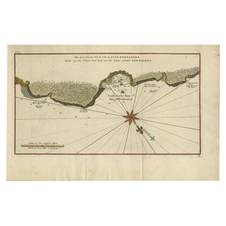
View AllJuan Fernandez Island Map – Antique Chilean Chart circa 1750
Located in Langweer, NL
Antique map titled 'Plan de la Côte du N.E. de l 'Ile de Juan Fernandes'.
Map of the northeast coast of the island of Juan Fernandez with Cumberland Bay, South America. In 1740 Ans...
Category
Antique 18th Century Maps
Materials
Paper
$330 Sale Price
20% Off
Antique Map of the Bay and Rocks of Petatlan by Anson, 1749
Located in Langweer, NL
Antique map titled 'Baye et Rochers de Petaplan (..) - De Baay en de Rotsen van Petaplan (..)'. Original antique map of the bay and rocks of Petatlan, Mexico. This map originates fro...
Category
Antique 18th Century Maps
Materials
Paper
$151 Sale Price
20% Off
Antique Map of Coiba Island, Panama, South America, C.1740
Located in Langweer, NL
Antique map titled 'Plan de la partie orientale de l'Isle de Quibo'. Map of the eastside of Coiba Island (Quibo), Panama, showing the shoreline around Port de Dames indicating soft s...
Category
Antique 18th Century Maps
Materials
Paper

$321 Sale Price
20% Off
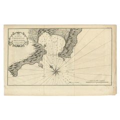
Antique Map of the Port of Zihuatanejo in Mexico, c.1740
Located in Langweer, NL
Antique map titled 'Plan du Port de Chequetan ou Seguataneo'. Map of the Mexican port of Zihuatanejo. This area was originally named Cihuatlán in Aztec, which means 'Place of Women,'...
Category
Antique 18th Century Maps
Materials
Paper
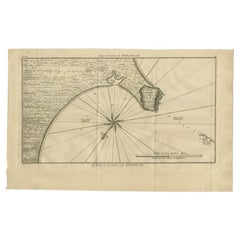
Antique Map of a Bay on the Coast of Chile, South America, c.1749
Located in Langweer, NL
Antique map titled 'Plan van een Baai en Haven aan de Kust van Chili (..) - Plan d'une Baye de la Côte du Chili (..)'. Original antique map of a bay on the coast of Chile discovered ...
Category
Antique 18th Century Maps
Materials
Paper

$302 Sale Price
20% Off
Antique Map of Juan Fernandez Island and Cumberland Bay, Chile - c. '1749'
Located in Langweer, NL
Antique map titled 'Plan de la Côte du N.E. de l 'Ile de Juan Fernandes - Schets van den Noord-Oost kant van het eiland Juan Fernandes '. This map depicts the northeast coast of the ...
Category
Antique Mid-18th Century Maps
Materials
Paper

$189 Sale Price
20% Off
You May Also Like
West Coast of Africa, Guinea & Sierra Leone: An 18th Century Map by Bellin
By Jacques-Nicolas Bellin
Located in Alamo, CA
Jacques Bellin's copper-plate map entitled "Partie de la Coste de Guinee Dupuis la Riviere de Sierra Leona Jusquau Cap das Palmas", depicting the coast of Guinea and Sierra Leone in ...
Category
Antique Mid-18th Century French Maps
Materials
Paper

Original Antique Map of South America. C.1780
Located in St Annes, Lancashire
Great map of South America
Copper-plate engraving
Published C.1780
Two small worm holes to left side of map
Unframed.
Category
Antique Early 1800s English Georgian Maps
Materials
Paper

California, Alaska and Mexico: 18th Century Hand-Colored Map by de Vaugondy
By Didier Robert de Vaugondy
Located in Alamo, CA
This is an 18th century hand-colored map of the western portions of North America entitled "Carte de la Californie et des Pays Nord-Ouest separés de l'Asie par le détroit d'Anian, ex...
Category
Antique 1770s French Maps
Materials
Paper

Plymouth, England: A Hand-Colored 17th Century Sea Chart by Captain Collins
By Captain Greenvile Collins
Located in Alamo, CA
This hand-colored sea chart of the area around Plymouth, England from "Great Britain's Coasting Pilot. Being a New and Exact Survey of the Sea-Coast of England", first published in 1...
Category
Antique Late 17th Century English Maps
Materials
Paper

Dartmouth, England: A Hand-Colored 17th Century Sea Chart by Captain Collins
By Captain Greenvile Collins
Located in Alamo, CA
This hand-colored sea chart of the area around Dartmouth, England is from "Great Britain's Coasting Pilot. Being a New and Exact Survey of the Sea-Coast of England", first published ...
Category
Antique Late 17th Century English Maps
Materials
Paper

St. Christophe 'St. Kitts' Island: An 18th Century Hand-colored Map by Bellin
By Jacques-Nicolas Bellin
Located in Alamo, CA
Jacques Bellin's copper-plate map of the Caribbean island of Saint Kitts entitled "Carte De De l'Isle St. Christophe Pour servir á l'Histoire Genle. des V...
Category
Antique Mid-18th Century French Maps
Materials
Paper

More Ways To Browse
Mexican Antiques
Royal Navy Antique
Framed Africa Maps
Map Of Israel
Teak Sphere
18th Century Scottish Collectibles
Map Of Mexican California
Ottoman Map
Antique Map Of Korea
Maps South East Asia
Antique Furniture Kansas City
Antique Great Lakes Map
Arnold And Son
Indianapolis Antique Furniture
Antique Map Of Jerusalem
Antique Maps Of Sicily
Antique Celestial Maps
Antique Compass Maritime Compasses