Items Similar to Original Antique Map of Friesland by Guicciardini, 1612


Want more images or videos?
Request additional images or videos from the seller
1 of 5
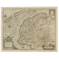
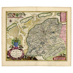
Original Antique Map of Friesland by Guicciardini, 1612
$527.18
$658.9820% Off
£392.38
£490.4820% Off
€440
€55020% Off
CA$722.11
CA$902.6420% Off
A$803.14
A$1,003.9320% Off
CHF 419.38
CHF 524.2220% Off
MX$9,773.40
MX$12,216.7520% Off
NOK 5,356.08
NOK 6,695.0920% Off
SEK 5,023.05
SEK 6,278.8220% Off
DKK 3,349.57
DKK 4,186.9620% Off
Shipping
Retrieving quote...The 1stDibs Promise:
Authenticity Guarantee,
Money-Back Guarantee,
24-Hour Cancellation
About the Item
Antique map titled 'Frisiae Occidentalis Typus'. Original antique map of the province of Friesland, the Netherlands. This map originates from 'Beschryvinghe van alle de Neder-Landen' by L. Guicciardini. Published 1612. Artists and Engravers: Lodovico Guicciardini (19 August 1521 ? 22 March 1589) was an Italian writer and merchant from Florence who lived primarily in Antwerp. He was the nephew of historian and diplomat Francesco Guicciardini.
Artist: Lodovico Guicciardini (19 August 1521 ? 22 March 1589) was an Italian writer and merchant from Florence who lived primarily in Antwerp. He was the nephew of historian and diplomat Francesco Guicciardini.
Condition: Very good, original folding line. General age-related toning, minor wear. Blank verso. Please study image carefully.
Date: 1612
Overall size: 36 x 30.5 cm.
Image size: 31 x 23 cm.
We sell original antique maps to collectors, historians, educators and interior decorators all over the world. Our collection includes a wide range of authentic antique maps from the 16th to the 20th centuries. Buying and collecting antique maps is a tradition that goes back hundreds of years. Antique maps have proved a richly rewarding investment over the past decade, thanks to a growing appreciation of their unique historical appeal. Today the decorative qualities of antique maps are widely recognized by interior designers who appreciate their beauty and design flexibility. Depending on the individual map, presentation, and context, a rare or antique map can be modern, traditional, abstract, figurative, serious or whimsical. We offer a wide range of authentic antique maps for any budget.
- Dimensions:Height: 12.01 in (30.5 cm)Width: 14.18 in (36 cm)Depth: 0 in (0.01 mm)
- Materials and Techniques:
- Period:
- Date of Manufacture:1612
- Condition:
- Seller Location:Langweer, NL
- Reference Number:Seller: BG-002291stDibs: LU3054326282012
About the Seller
5.0
Recognized Seller
These prestigious sellers are industry leaders and represent the highest echelon for item quality and design.
Platinum Seller
Premium sellers with a 4.7+ rating and 24-hour response times
Established in 2009
1stDibs seller since 2017
2,502 sales on 1stDibs
Typical response time: <1 hour
- ShippingRetrieving quote...Shipping from: Langweer, Netherlands
- Return Policy
Authenticity Guarantee
In the unlikely event there’s an issue with an item’s authenticity, contact us within 1 year for a full refund. DetailsMoney-Back Guarantee
If your item is not as described, is damaged in transit, or does not arrive, contact us within 7 days for a full refund. Details24-Hour Cancellation
You have a 24-hour grace period in which to reconsider your purchase, with no questions asked.Vetted Professional Sellers
Our world-class sellers must adhere to strict standards for service and quality, maintaining the integrity of our listings.Price-Match Guarantee
If you find that a seller listed the same item for a lower price elsewhere, we’ll match it.Trusted Global Delivery
Our best-in-class carrier network provides specialized shipping options worldwide, including custom delivery.More From This Seller
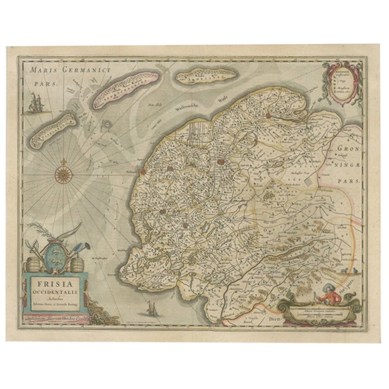
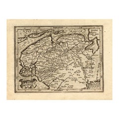
View AllAntique Map of Friesland, The Netherlands, 1638
Located in Langweer, NL
Antique map titled 'Frisia Occidentalis'.
Original antique map of Friesland, the Netherlands. First state, originating from 'Atlantis novi pars secunda' published 1638.
Artis...
Category
Antique 17th Century Maps
Materials
Paper
$455 Sale Price
20% Off
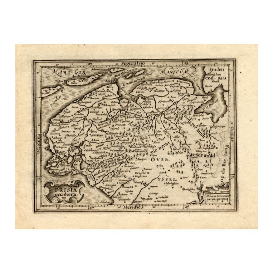
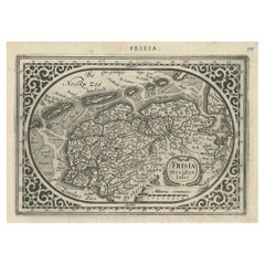
Antique Map of Friesland by Guicciardini, 1613
Located in Langweer, NL
Antique map titled 'Frisia Occidenta.' (Map of the province of Friesland, the Netherlands.) This original old antique print / plate originates from the scarse French edition of 'Desc...
Category
Antique 17th Century Maps
Materials
Paper
$268 Sale Price
20% Off
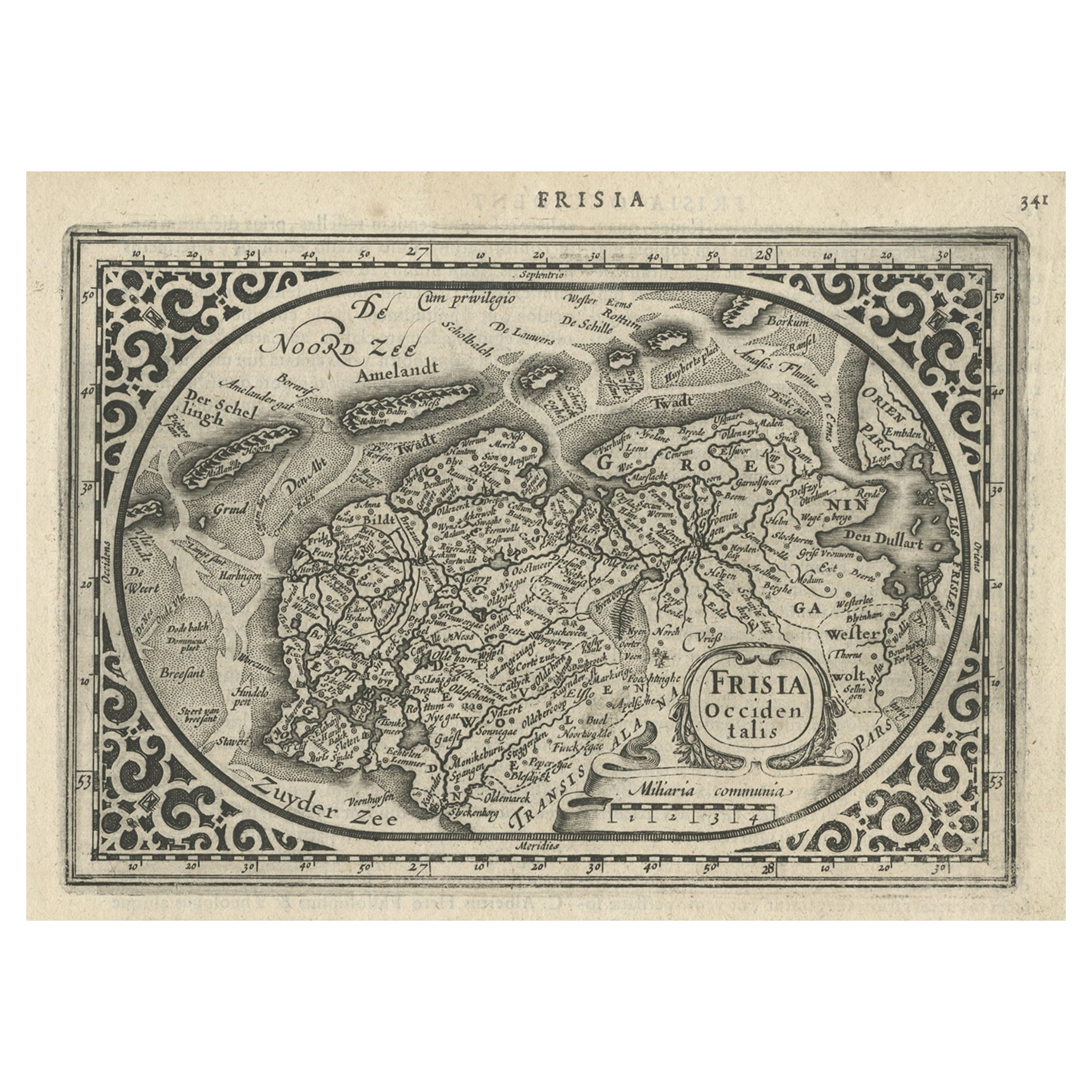
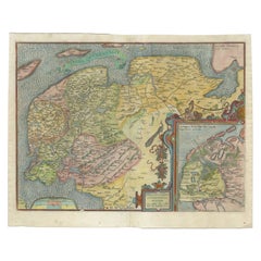
Antique Map of Friesland and Groningen, Provinces of the Netherlands, 1628
Located in Langweer, NL
Antique map Friesland titled 'Frisia Occidentalis'. Small, decorative map of the province of Friesland, the Netherlands. Second state, out of three, originating from 'Atlas Minor' by...
Category
Antique 17th Century Maps
Materials
Paper
$335 Sale Price
20% Off
Old Antique Map of the Province of Friesland, the Netherlands, c.1580
Located in Langweer, NL
Antique map titled 'Frisia Occidentalis'. Old map of the province of Friesland, the Netherlands. This map is also known as the 'Pauwenkaart' ('peacock map'), referring to the peacock next to the inset map. Based on a manuscript map...
Category
Antique 16th Century Maps
Materials
Paper
$910 Sale Price
20% Off
Antique Map of Friesland in the Netherlands, 1770
Located in Langweer, NL
Antique map titled 'De Synode van Friesland, in VI Klassen verdeeld door W.A. Bachiene?. Map of the province of Friesland, the Netherlands. This map originates from 'Nieuwe kerkelyke...
Category
Antique 18th Century Maps
Materials
Paper

$143 Sale Price
20% Off
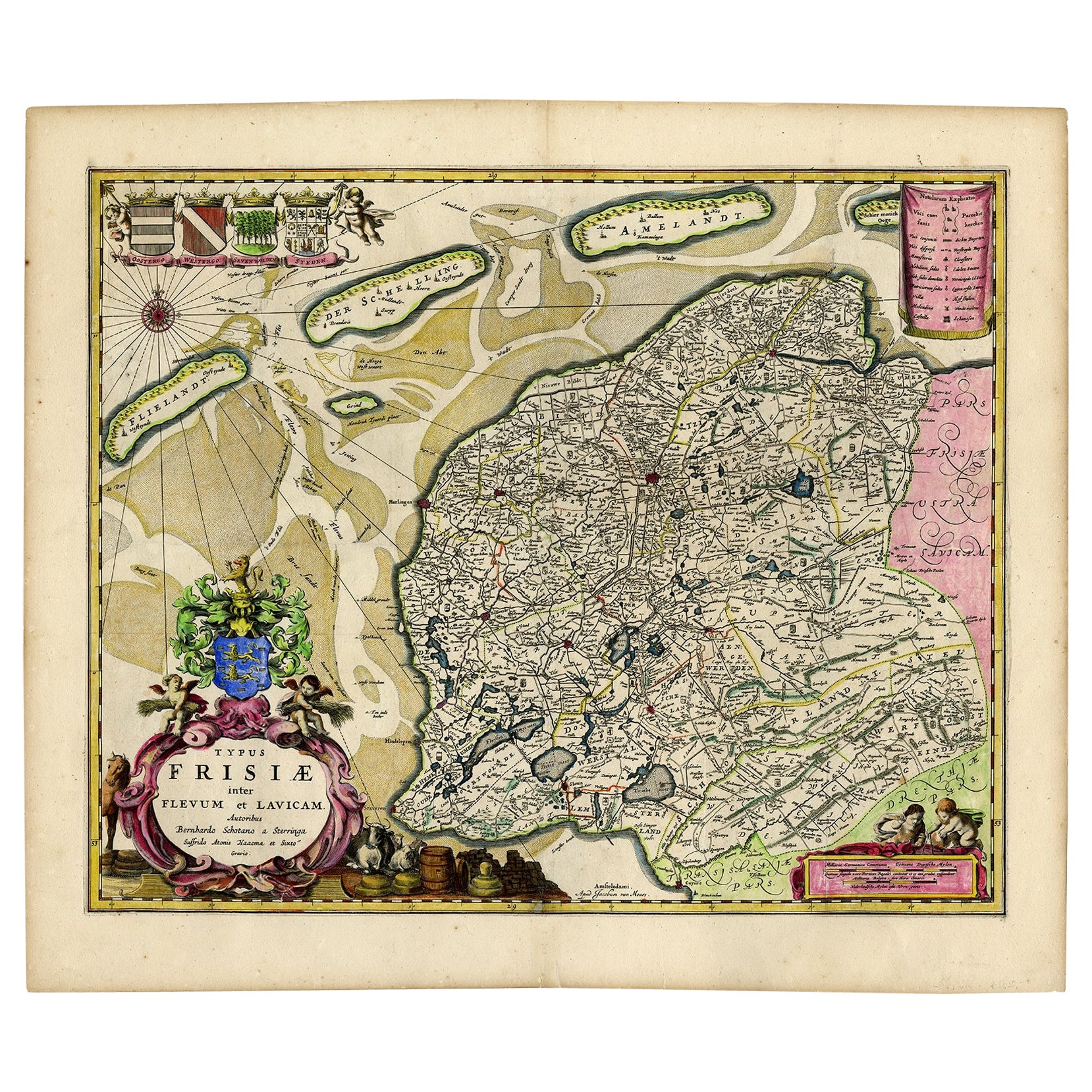
Antique Map of Friesland with Four Coats of Arms, 1664
Located in Langweer, NL
Antique map titled 'Typus Frisiae inter Fevum et Lavicam'. Original antique map of the province of Friesland, the Netherlands. Also shows the Wadden islands Vlieland, Terschelling and Ameland and part of Schiermonnikoog. With a decorative cartouche with two putti, livestock and cheese and milk barrels. Four coats...
Category
Antique 17th Century Maps
Materials
Paper
$1,389 Sale Price
20% Off
You May Also Like
1646 Jansson Map Entitled "Procinvia Connactiae, " Ric.a006
Located in Norton, MA
1646 Jansson map entitled
"Procinvia connactiae,"
Ric.a006
Description: The PROVINCE of CONNAVGT 490 x 380From vol 4 of Jansson's Atlas Novus 1646, published in Amsterdam with...
Category
Antique 17th Century Unknown Maps
Materials
Paper

1643 Willem&Joan Blaeu Map NW Flanders "Flandriae Teutonicae Pars Prientalior
Located in Norton, MA
1643 Willem and Joan Blaeu map of northwest Flanders, entitled
"Flandriae Teutonicae Pars Prientalior,"
Ric0012
" Authentic" - Map of the northwest Fl...
Category
Antique 17th Century Dutch Maps
Materials
Paper

1636 Jansson Map of Ireland Entitled "Comitatus Lageniae, " Ric.a007
Located in Norton, MA
1646 Jansson map entitled
"Procinvia connactiae,"
Ric.a006
Description: The PROVINCE of CONNAVGT 490 x 380From vol 4 of Jansson's Atlas Novus 1646, published in Amsterdam with...
Category
Antique 17th Century Unknown Maps
Materials
Paper

1752 Vaugoundy Map of Flanders : Belgium, France, and the Netherlands, Ric.a002
Located in Norton, MA
Large Vaugoundy Map of Flanders:
Belgium, France, and the Netherlands
Colored -1752
Ric.a002
Description: This is a 1752 Didier Robert de Vaugondy map of Flanders. The map de...
Category
Antique 17th Century Unknown Maps
Materials
Paper

1590 Ortelius Map of Calais and Vermandois, France and Vicinity Ric.a014
Located in Norton, MA
1590 Ortelius map of
Calais and Vermandois, France and Vicinity
Ric.a014
Two rare regional Abraham Ortelius maps on a single folio sheet. Left map, entitled Caletensium, depic...
Category
Antique 16th Century Dutch Maps
Materials
Paper

1657 Janssonius Map of Vermandois and Cappelle, Ric. A-004
Located in Norton, MA
1657 Janssonius map of
Vermandois and Cappelle
Ric.a004
Description: Antique map of France titled 'Descriptio Veromanduorum - Gouvernement de la Cappelle'. Two detailed maps o...
Category
Antique 17th Century Unknown Maps
Materials
Paper

More Ways To Browse
Map Of Singapore
Migeon Migeon
Scottish Coat Of Arms
Antique Maps Of Canada
Antique Railroad Maps
Relief Map
Antique Map Of Venice
Antique Map Of Georgia
Antique Nautical Charts
Hand Painted Antique Map
Antique Maps New Zealand
Antique Maps Persia
Map Railroad
Mariner Furniture
Vintage Glass Map
Antique Furniture Cyprus
Antique Linen Map
Caribbean Colonial Furniture