Items Similar to Striking Large Format Antique Map of Southeastern France, 1799


Want more images or videos?
Request additional images or videos from the seller
1 of 5
Striking Large Format Antique Map of Southeastern France, 1799
$623.03
$778.7920% Off
£463.72
£579.6520% Off
€520
€65020% Off
CA$853.40
CA$1,066.7520% Off
A$949.17
A$1,186.4620% Off
CHF 495.63
CHF 619.5320% Off
MX$11,550.38
MX$14,437.9720% Off
NOK 6,329.91
NOK 7,912.3820% Off
SEK 5,936.34
SEK 7,420.4220% Off
DKK 3,958.58
DKK 4,948.2220% Off
Shipping
Retrieving quote...The 1stDibs Promise:
Authenticity Guarantee,
Money-Back Guarantee,
24-Hour Cancellation
About the Item
Antique map titled 'The South Eastern Part of France which includes Roussillon-Languedoc, with a Great Portion of Rouergue and Auvergne-Provence-Dauphine, and the Whole Frontier of Italy'.
Striking large format map of Southeastern France, showing the region from the Mediterranean Coast and Gulf of Lyon to the Alps and extending into Piemonte. One of the most detailed English language maps of the region. Source unknown, to be determined.
Artists and Engravers: Made by 'William Faden' after an anonymous artist. William Faden (1749 – 1836) was an English cartographer and a publisher of maps. He was the royal geographer to King George III. He replaced Thomas Jeffreys in that role. The title of "geographer to the king" was given to various people in the 18th century, including John Senex, Herman Moll, Emmanuel Bowen and Thomas Jeffreys. All of these men, including William Faden, were engravers and publishers, not scholars or academics. Their part was to publish and supply maps to the crown and parliament.
- Dimensions:Height: 23 in (58.4 cm)Width: 32.56 in (82.7 cm)Depth: 0 in (0.02 mm)
- Materials and Techniques:
- Period:1790-1799
- Date of Manufacture:1799
- Condition:Wear consistent with age and use. Condition: Fair/good, general age-related toning. Original folding line. Few tears in margin, one in left margin sl. affecting image. Minor wear and soiling, blank verso. Please study image carefully.
- Seller Location:Langweer, NL
- Reference Number:Seller: PC-58930 1stDibs: LU3054327227242
About the Seller
5.0
Recognized Seller
These prestigious sellers are industry leaders and represent the highest echelon for item quality and design.
Platinum Seller
Premium sellers with a 4.7+ rating and 24-hour response times
Established in 2009
1stDibs seller since 2017
2,502 sales on 1stDibs
Typical response time: <1 hour
- ShippingRetrieving quote...Shipping from: Langweer, Netherlands
- Return Policy
Authenticity Guarantee
In the unlikely event there’s an issue with an item’s authenticity, contact us within 1 year for a full refund. DetailsMoney-Back Guarantee
If your item is not as described, is damaged in transit, or does not arrive, contact us within 7 days for a full refund. Details24-Hour Cancellation
You have a 24-hour grace period in which to reconsider your purchase, with no questions asked.Vetted Professional Sellers
Our world-class sellers must adhere to strict standards for service and quality, maintaining the integrity of our listings.Price-Match Guarantee
If you find that a seller listed the same item for a lower price elsewhere, we’ll match it.Trusted Global Delivery
Our best-in-class carrier network provides specialized shipping options worldwide, including custom delivery.More From This Seller
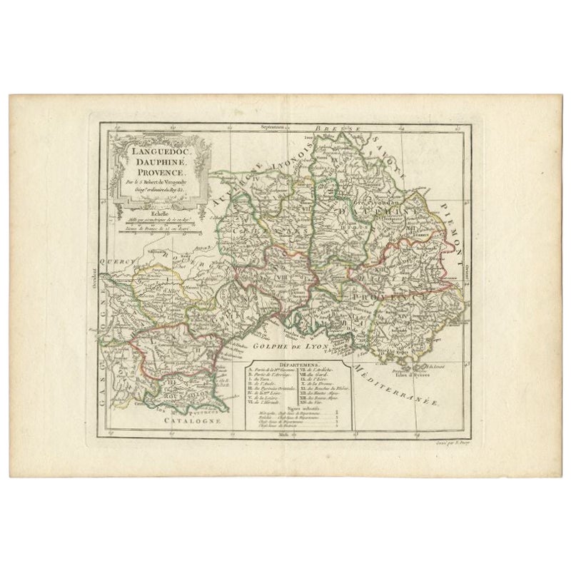
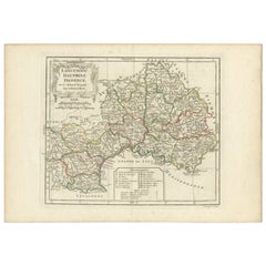
View AllAntique Map of Southeastern France by Vaugondy, c.1790
Located in Langweer, NL
"Antique map titled 'Languedoc, Dauphiné, Province'. Beautiful antique map of Southeastern France with decorative cartouche. Map includes topographical detail as well as a reference ...
Category
Antique 18th Century Maps
Materials
Paper
$153 Sale Price
20% Off
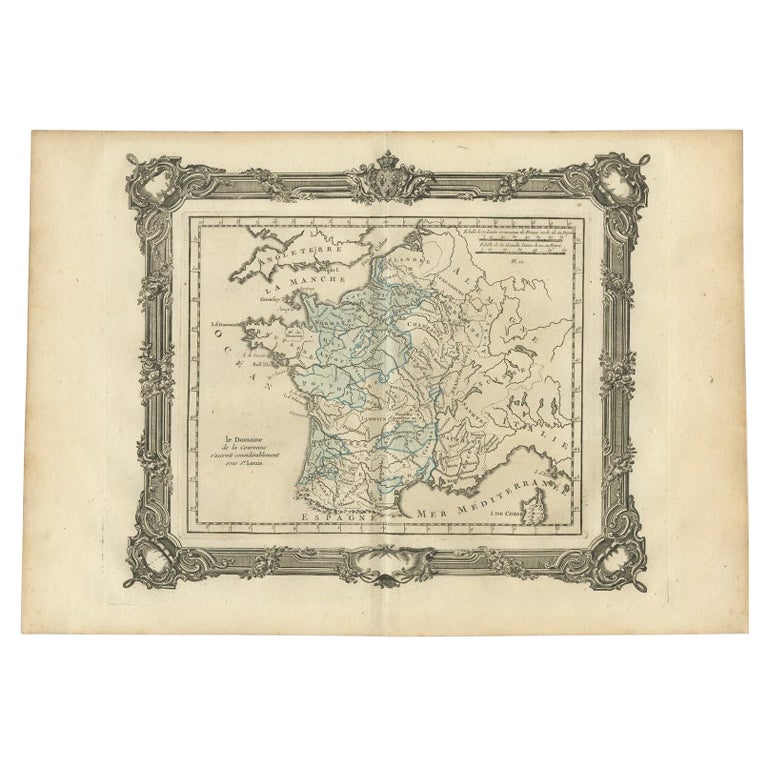
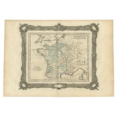
Antique Map of France under the Reign of St. Louis by Zannoni, 1765
Located in Langweer, NL
Antique map France titled 'Le Domaine de la Couronne (..)'. Beautiful old map of France. This map originates from 'Atlas Historique de la France Ancienne et Moderne' by M. Rizzi Zann...
Category
Antique 18th Century Maps
Materials
Paper
$143 Sale Price
20% Off
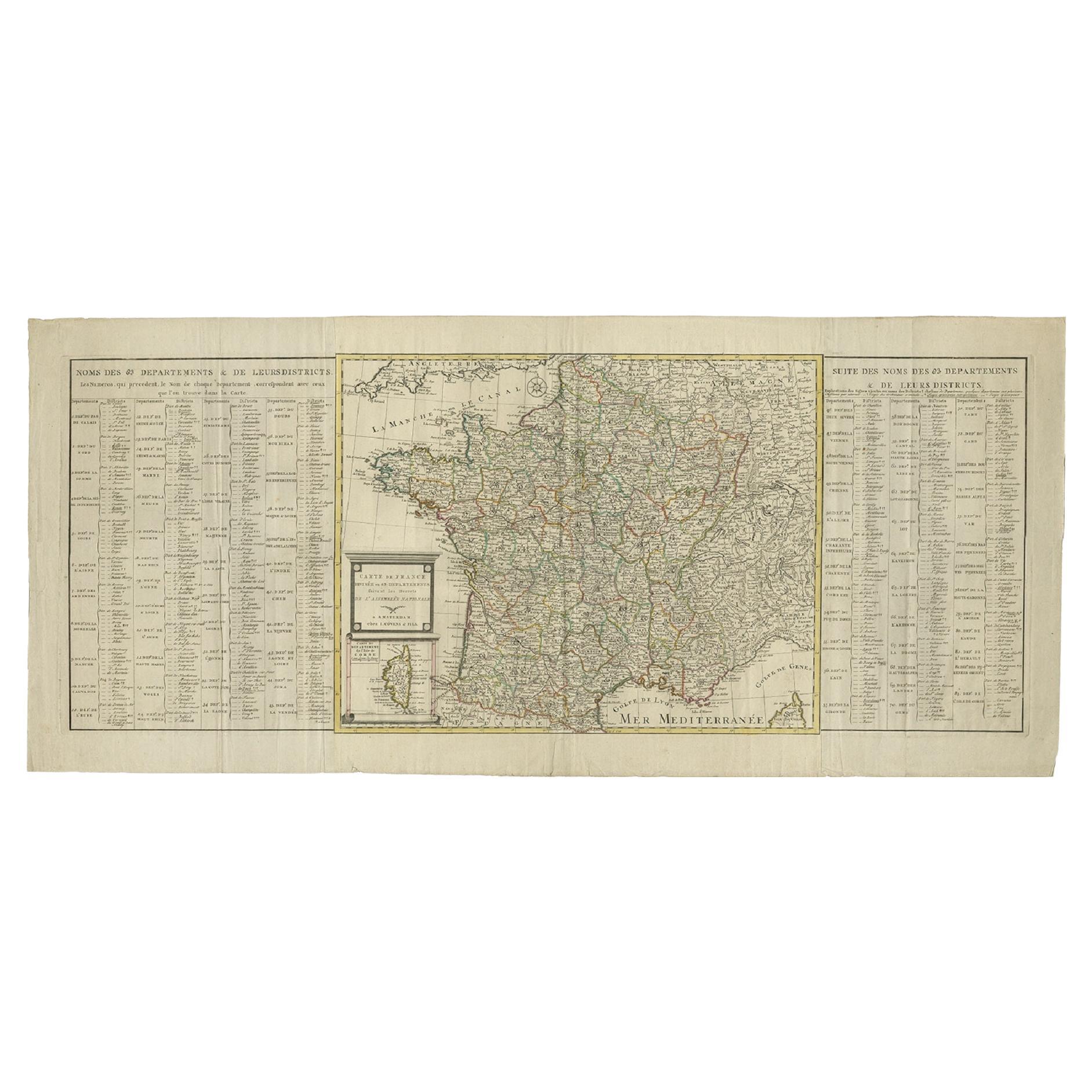
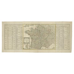
Antique Map of France by Covens & Son, c.1790
Located in Langweer, NL
A detailed description of the 'Carte de France divisée en 83 Departements (..)', an antique map circa 1790, along with information about its publishers, Covens & Mortier:
**Title**:...
Category
Antique 18th Century Maps
Materials
Paper
$431 Sale Price
20% Off
Antique Map of France by Balbi '1847'
Located in Langweer, NL
Antique map titled 'France'. Original antique map of France. This map originates from 'Abrégé de Géographie (..)' by Adrien Balbi. Published 1847.
Category
Antique Mid-19th Century Maps
Materials
Paper

$119 Sale Price
20% Off
Antique Map of the Lorraine Region, c.1760
Located in Langweer, NL
Untitled antique map of the Lorraine region, France. A cultural and historical region in north-eastern France, now located in the administrative region of Grand Est. Lorraine's name ...
Category
Antique 18th Century Maps
Materials
Paper

$210 Sale Price
20% Off
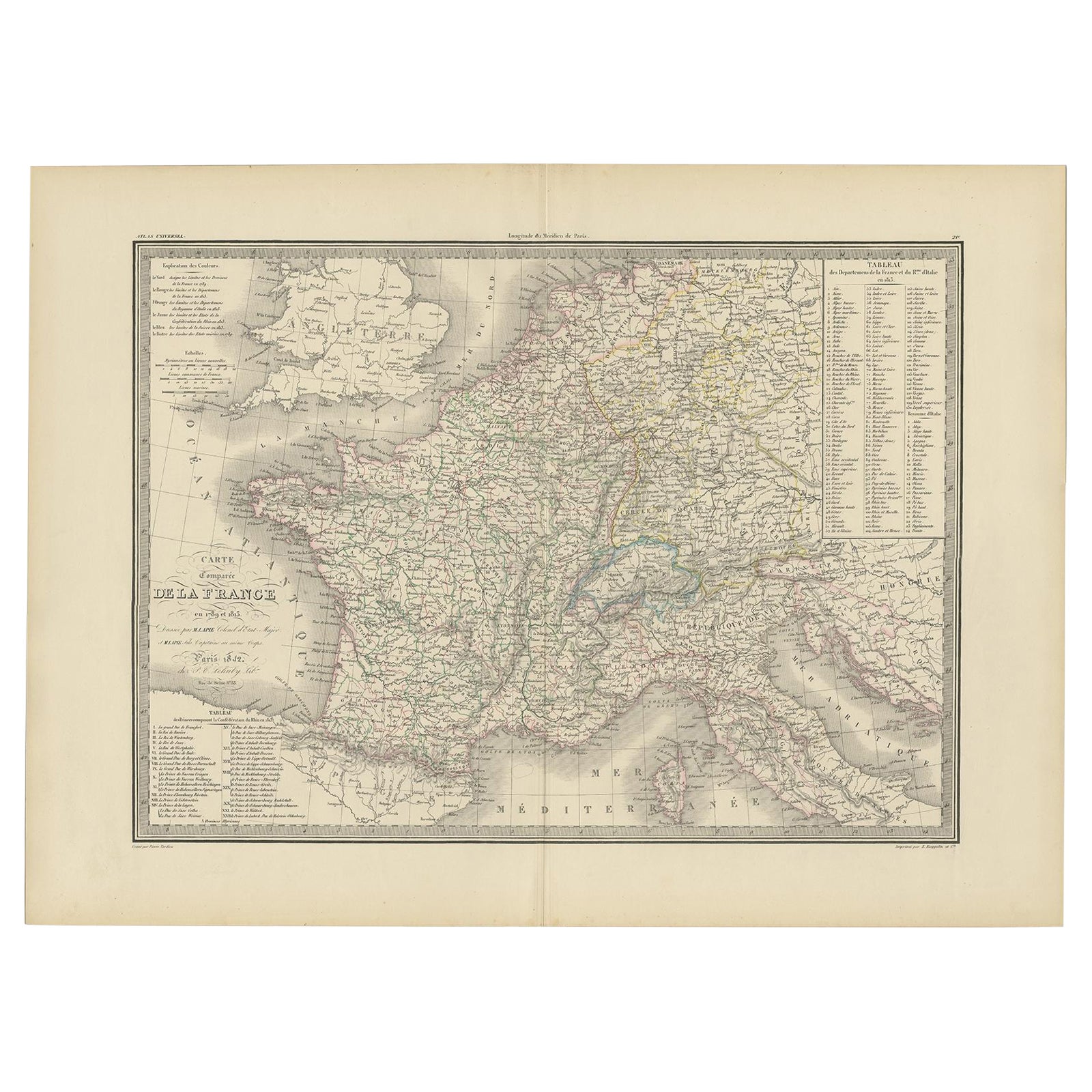
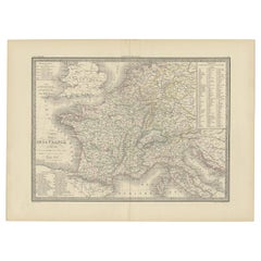
Antique Map of France with Surrounding Countries, 1842
Located in Langweer, NL
Antique map titled 'Carte comparée de la France en 1789 et 1813'. Map of France. This map originates from 'Atlas universel de géographie ancienne et moderne (..)' by Pierre M. Lapie ...
Category
Antique 19th Century Maps
Materials
Paper
$287 Sale Price
20% Off
You May Also Like
Large 19th Century Map of France
Located in Pease pottage, West Sussex
Large 19th Century Map of France.
Remarkable condition, with a pleasing age worn patina.
Recently framed.
France Circa 1874.
Category
Antique Late 19th Century French Maps
Materials
Linen, Paper

1771 Bonne Map of Poitou, Touraine and Anjou, France, Ric.a015
Located in Norton, MA
1771 Bonne Map of Poitou,
Touraine and Anjou, France
Ric.a015
1771 Bonne map of Potiou, Touraine and Anjou entitled "Carte des Gouvernements D'Anjou et du Saumurois, de la Touraine, du Poitou,du Pays d'aunis, Saintonge?Angoumois,"
Carte des gouvernements d'Anjou et du Saumurois, de la Touraine, du Poitou, du Pays d'Aunis, Saintonge-Angoumois. Projettee et assujettie au ciel par M. Bonne, Hyd. du Roi. A Paris, Chez Lattre, rue St. Jacques a la Ville de Bord(ea)ux. Avec priv. du Roi. 1771. Arrivet inv. & sculp., Atlas moderne ou collection de cartes sur toutes...
Category
Antique 17th Century Unknown Maps
Materials
Paper

Original Antique Map of Europe, Arrowsmith, 1820
Located in St Annes, Lancashire
Great map of Europe
Drawn under the direction of Arrowsmith.
Copper-plate engraving.
Published by Longman, Hurst, Rees, Orme and Brown, 1820
...
Category
Antique 1820s English Maps
Materials
Paper

Large Original Antique Map of Lombardy and Venice, Italy. John Dower, 1861
Located in St Annes, Lancashire
Great map of Lombardy and Venice
Lithograph engraving by John Dower
Original colour
Published, 1861
Unframed
Good condition / crease to bottom left corner
Free shipping
Category
Antique 1860s English Victorian Maps
Materials
Paper

Original Antique Map of Hungary, Arrowsmith, 1820
Located in St Annes, Lancashire
Great map of Hungary
Drawn under the direction of Arrowsmith.
Copper-plate engraving.
Published by Longman, Hurst, Rees, Orme and Brown, 1820
Unframed.
Category
Antique 1820s English Maps
Materials
Paper

Geographical Antique Map of Principality of Monaco
By Bruno Santini
Located in Alessandria, Piemonte
ST/609 - Interesting antique color map of Monaco Principality in French language : "Carte qui contient le Principauté de Piémont, le Monferrat et la comté de...
Category
Antique Late 18th Century Italian Other Maps
Materials
Paper

More Ways To Browse
Thomas Crown
King William Iii
Antique Maps Of Sicily
Antique Celestial Maps
Antique Compass Maritime Compasses
Bengal Map
J C Walker Map
Map Of Ancient Greece
Ptolemy Map
Antique Marine Compass
Map Of Jerusalem
1820 World Map
Cyprus Antique Maps
Antique Ecuador
Antique Map Of Thailand
Antique Mississippi Map
Antique Ohio Maps
Burgundy Map