Items Similar to Very Large Vintage Map of Canada, German, Education, Institution, Cartography

Want more images or videos?
Request additional images or videos from the seller
1 of 13
Very Large Vintage Map of Canada, German, Education, Institution, Cartography
$2,952.09
£2,153
€2,511
CA$4,042.43
A$4,494.63
CHF 2,346.85
MX$54,710.57
NOK 29,944.75
SEK 28,056.80
DKK 18,740.04
Shipping
Retrieving quote...The 1stDibs Promise:
Authenticity Guarantee,
Money-Back Guarantee,
24-Hour Cancellation
About the Item
This is a very large vintage map of Canada. A German, quality printed educational or institution map, dating to the mid 20th century, circa 1965.
Striking proportion with superb attention to detail
Displays a desirable aged patina and in good order
Wonderfully printed upon a large roll of canvas-backed paper
Full colour with topographical shading for altitude
Depicts the land mass of Canada, United States of America, Greenland and Iceland
Annotated with an extensive key, detailing cities, borders and height et al
Printed in Germany by Georg Westermann, dated to March 1965
Set between a pair of ebonized spars for ease of wall mounting
This is a captivating vintage map of Canada, with impressive proportion and replete with fascinating attention to detail. Of educational or institutional quality, it could grace any large wall. Delivered ready to display.
Dimensions:
Max width: 216cm (85'')
Max depth: 3cm (1.25'')
Max height: 197cm (77.5'')
Map width: 205cm (80.75'')
Map height: 191cm (75.25'').
- Dimensions:Height: 77.56 in (197 cm)Width: 85.04 in (216 cm)Depth: 1.19 in (3 cm)
- Materials and Techniques:
- Place of Origin:
- Period:
- Date of Manufacture:circa 1965
- Condition:Wear consistent with age and use. Presented in very good vintage condition.
- Seller Location:Hele, Devon, GB
- Reference Number:Seller: 18.81691stDibs: LU2645327345102
About the Seller
5.0
Platinum Seller
Premium sellers with a 4.7+ rating and 24-hour response times
Established in 2005
1stDibs seller since 2017
1,031 sales on 1stDibs
Typical response time: 1 hour
- ShippingRetrieving quote...Shipping from: Hele, Devon, United Kingdom
- Return Policy
Authenticity Guarantee
In the unlikely event there’s an issue with an item’s authenticity, contact us within 1 year for a full refund. DetailsMoney-Back Guarantee
If your item is not as described, is damaged in transit, or does not arrive, contact us within 7 days for a full refund. Details24-Hour Cancellation
You have a 24-hour grace period in which to reconsider your purchase, with no questions asked.Vetted Professional Sellers
Our world-class sellers must adhere to strict standards for service and quality, maintaining the integrity of our listings.Price-Match Guarantee
If you find that a seller listed the same item for a lower price elsewhere, we’ll match it.Trusted Global Delivery
Our best-in-class carrier network provides specialized shipping options worldwide, including custom delivery.More From This Seller
View AllAntique North America Map, USA, Canada, Mexico, Cartography, Colton, Victorian
Located in Hele, Devon, GB
This is an antique North America map. A USA, framed lithography atlas engraving of the continent by JH Colton, dating to the Victorian period and later, circa 1860.
Fascinating, large framed map...
Category
Antique Mid-19th Century American Victorian Maps
Materials
Paper

Vintage Reproduction 17th Century Map of Europe, American, Cartography, Blaeuw
Located in Hele, Devon, GB
This is a vintage reproduction map of Europe. An American, paper stock cartography print in frame after the work by Blaeuw, dating to the late 20t...
Category
Late 20th Century Central American Mid-Century Modern Maps
Materials
Glass, Wood, Paper

Antique Lithography Map, Cumberland, English, Framed, Cartography, Victorian
Located in Hele, Devon, GB
This is an antique lithography map of Cumberland. An English, framed atlas engraving of cartographic interest, dating to the mid 19th century and la...
Category
Antique Mid-19th Century British Victorian Maps
Materials
Wood

Large Vintage France Map, Continental, Historical Cartography, Late 20th Century
Located in Hele, Devon, GB
This is a large vintage map of France. A Continental, framed example of historical cartography, dating to the late 20th century, circa 1970.
Fas...
Category
Late 20th Century European Mid-Century Modern Prints
Materials
Glass, Wood, Paper

Antique Lithography Map, Western Russia, English, Framed, Cartography, Victorian
Located in Hele, Devon, GB
This is an antique lithography map of Western Russia. An English, framed atlas engraving of cartographic interest by John Rapkin, dating to the early Victorian period and later, circ...
Category
Antique Mid-19th Century British Early Victorian Maps
Materials
Wood

Antique Lithography Map, Westmoreland, English, Framed, Cartography, Victorian
Located in Hele, Devon, GB
This is an antique lithography map of Westmoreland. An English, framed atlas engraving of cartographic interest, dating to the mid 19th century and later.
Superb lithography of the ...
Category
Antique Mid-19th Century British Victorian Maps
Materials
Wood
You May Also Like
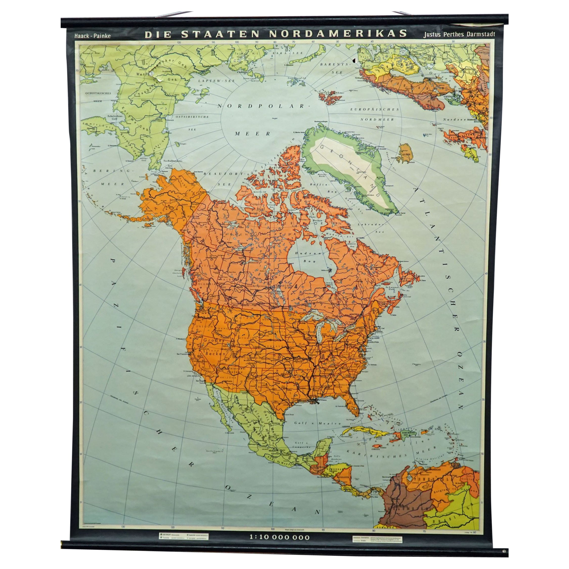
Vintage Map Wall Chart Countries of North America Rollable Mural Poster
Located in Berghuelen, DE
The vintage pull-down school map illustrates the countries / states of North America. Published by Haack-Painke Justus Perthes Darmstadt. Colorful print on paper reinforced with canv...
Category
Late 20th Century German Country Prints
Materials
Canvas, Wood, Paper

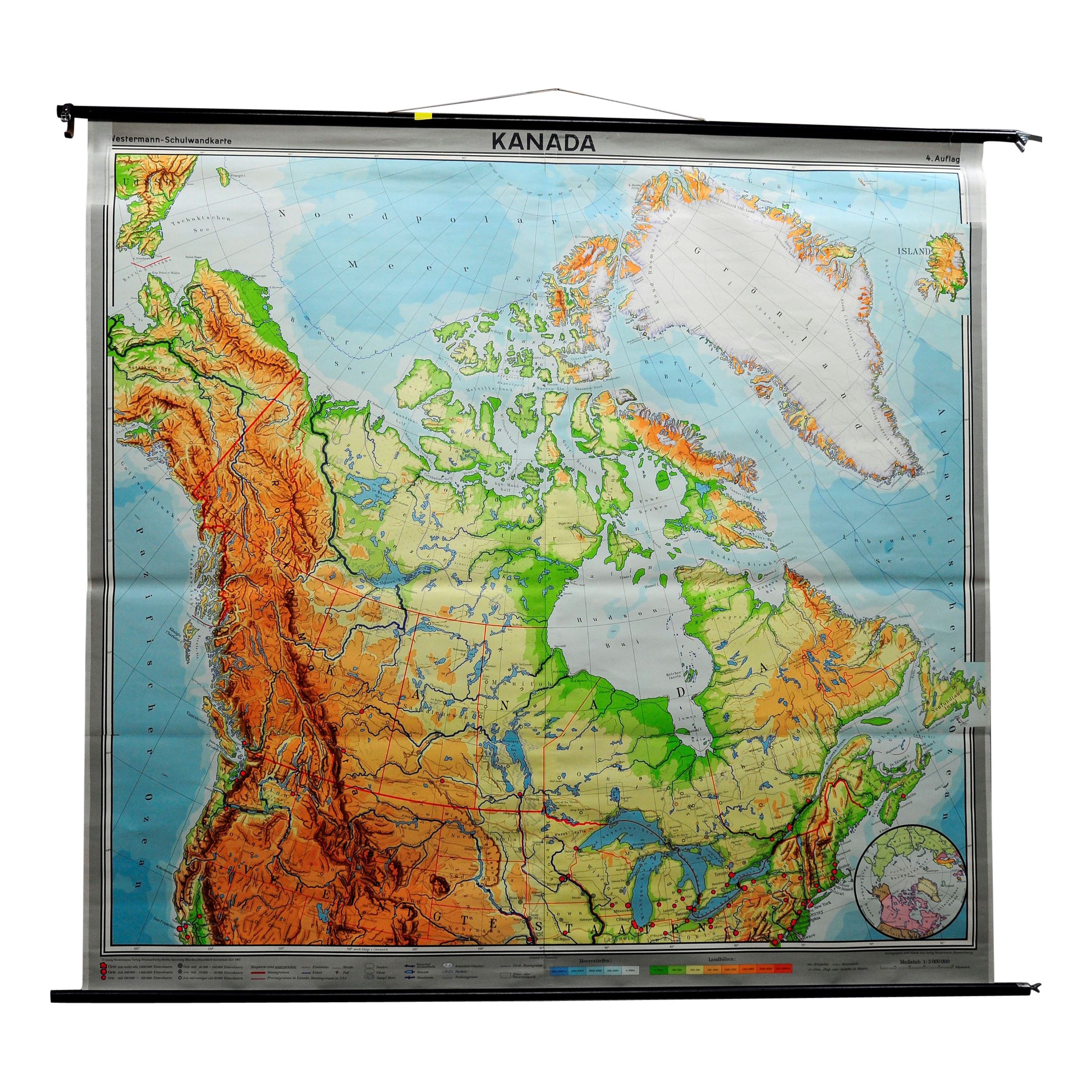
Canada Greenland North America Map Vintage Mural Rollable Wall Chart Countrycore
Located in Berghuelen, DE
A classical pull-down map of Canada and Greenland (North American Continent). Used as teaching material in German schools. Colorful print on paper reinforced with canvas. Published b...
Category
Vintage 1970s German Country Posters
Materials
Canvas, Wood

Large University Chart “Political Map of North America” by Bacon
Located in Godshill, Isle of Wight
Large University chart “Political Map of North America” by Bacon
W&A K Johnston’s Charts of Political Maps by G W Bacon,
This is colorful Physical ...
Category
Early 20th Century American Empire Posters
Materials
Linen

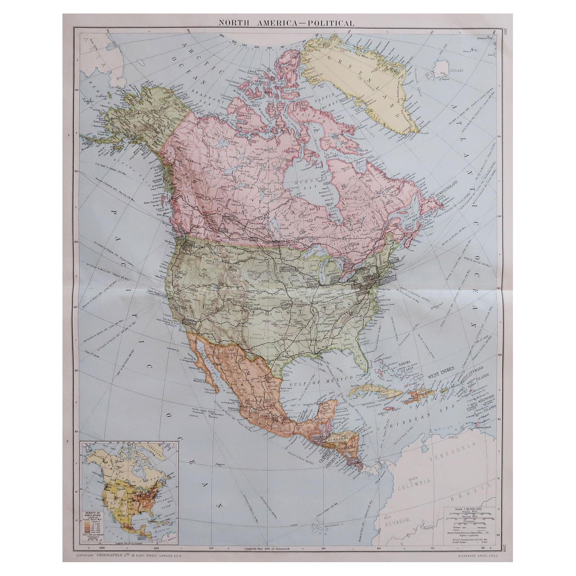
Large Original Vintage Map of North America, circa 1920
Located in St Annes, Lancashire
Great map of North America
Original color. Good condition
Published by Alexander Gross
Unframed.
Category
Vintage 1920s English Edwardian Maps
Materials
Paper

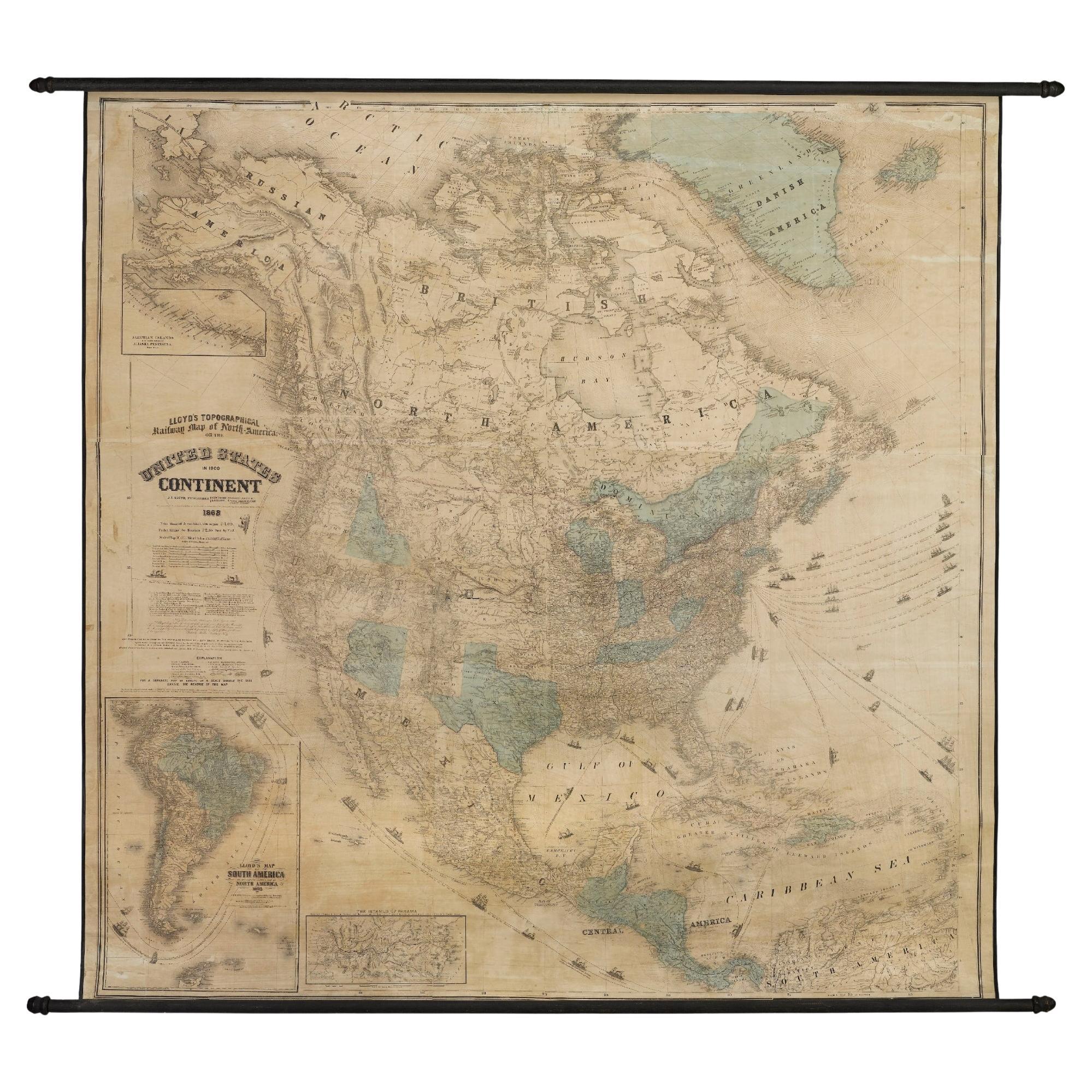
1868 "Lloyd's Topographical Railway Map of North America..." Hanging Wall Map
Located in Colorado Springs, CO
Presented is “Lloyd's Topographical Railway Map of North-America, or the United States Continent in 1900.” This map was published by J. T. Lloyd, in New York, in 1868. A large, hangi...
Category
Antique 1860s American Late Victorian Maps
Materials
Linen, Paper

Late 20th Century Educational Geographic Map - European Countries
Located in Hook, Hampshire
Late 20th Century Educational Geographic Map – European Countries
Late 20th Century Educational Geographic Map – European Countries. Good quality roll up s...
Category
Late 20th Century Czech Posters
Materials
Cotton

More Ways To Browse
The Vintage Map
Large Vintage Map
Large Wall Maps
Maps Rolled
Ptolemy Map
Map Of Jerusalem
1820 World Map
Cyprus Antique Maps
Antique Ecuador
Antique Map Of Thailand
Antique Mississippi Map
Antique Ohio Maps
Burgundy Map
John Speed Maps
Antique Map Of Turkish Empire
Antique Portuguese Scales
Canadian Atlas Furniture
Prussia Map