Items Similar to The Fateful Track of The Burke and Wills Expedition in Australia's Outback, 1862

Want more images or videos?
Request additional images or videos from the seller
1 of 7
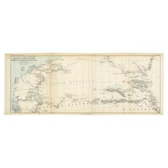
The Fateful Track of The Burke and Wills Expedition in Australia's Outback, 1862
$258.80
$323.5020% Off
£192.66
£240.8220% Off
€216
€27020% Off
CA$354.49
CA$443.1120% Off
A$394.27
A$492.8420% Off
CHF 205.88
CHF 257.3420% Off
MX$4,797.85
MX$5,997.3120% Off
NOK 2,629.35
NOK 3,286.6820% Off
SEK 2,465.86
SEK 3,082.3320% Off
DKK 1,644.33
DKK 2,055.4220% Off
Shipping
Retrieving quote...The 1stDibs Promise:
Authenticity Guarantee,
Money-Back Guarantee,
24-Hour Cancellation
About the Item
The map depicts the route of the Burke and Wills expedition, one of the most famous and tragic explorations in Australian history. This journey was the first to cross the Australian continent from south to north, starting in Melbourne and reaching the Gulf of Carpentaria. Led by Robert O'Hara Burke and William John Wills, the expedition set out in 1860 with the aim of opening up the interior for pastoral use and establishing a northern coastline for trade. However, due to a series of misfortunes and mistakes, both leaders perished on the return journey in 1861. The only surviving member of the expedition's leadership was John King, who was helped by the local Indigenous people.
The expedition in more detail:
The Burke and Wills expedition, formally known as the Victorian Exploring Expedition, was an ambitious undertaking to cross the Australian continent from south to north. It began in 1860, led by Robert O'Hara Burke and William John Wills, with the aim of charting a route from Melbourne in Victoria to the Gulf of Carpentaria in Queensland, which was believed to be Australia's inland sea, if it existed.
The venture was well-funded and equipped with the latest technology, including camels for desert transport. Despite this, the expedition is often remembered as a tragic example of poor planning and leadership. Burke, who had no exploration experience, made several critical errors in decision-making and management. The expedition reached the Gulf of Carpentaria in February 1861, but the return journey was marred by misfortune.
On their return, the main party was forced to leave supplies at Cooper Creek while Burke, Wills, King, and Gray attempted the final leg of the journey. Gray died along the way, and when Burke, Wills, and King reached the supply depot, they found it deserted, as the support team had waited longer than planned but finally left, believing the main party to be lost.
Burke and Wills both died of malnutrition and exhaustion in the harsh environment. John King was the sole survivor of the leadership group, thanks to the aid of local Indigenous people. The expedition's aftermath led to public outcry over the perceived mismanagement and became a cautionary tale of exploration in Australia.
Despite its tragic end, the Burke and Wills expedition is considered significant for the extensive scientific observations and surveys made, which contributed valuable knowledge of the Australian outback and its potential for agriculture and settlement.
- Dimensions:Height: 15.75 in (40 cm)Width: 7.68 in (19.5 cm)Depth: 0 in (0.02 mm)
- Materials and Techniques:
- Period:
- Date of Manufacture:1862
- Condition:Good. Sharp print on very thin paper. Folds as issued. Tears in most folds, easy to repair or support with archival tape. Lower left margin cut short. Please study the images carefully.
- Seller Location:Langweer, NL
- Reference Number:Seller: BG-13699-51stDibs: LU3054338355962
About the Seller
5.0
Recognized Seller
These prestigious sellers are industry leaders and represent the highest echelon for item quality and design.
Platinum Seller
Premium sellers with a 4.7+ rating and 24-hour response times
Established in 2009
1stDibs seller since 2017
2,508 sales on 1stDibs
Typical response time: <1 hour
- ShippingRetrieving quote...Shipping from: Langweer, Netherlands
- Return Policy
Authenticity Guarantee
In the unlikely event there’s an issue with an item’s authenticity, contact us within 1 year for a full refund. DetailsMoney-Back Guarantee
If your item is not as described, is damaged in transit, or does not arrive, contact us within 7 days for a full refund. Details24-Hour Cancellation
You have a 24-hour grace period in which to reconsider your purchase, with no questions asked.Vetted Professional Sellers
Our world-class sellers must adhere to strict standards for service and quality, maintaining the integrity of our listings.Price-Match Guarantee
If you find that a seller listed the same item for a lower price elsewhere, we’ll match it.Trusted Global Delivery
Our best-in-class carrier network provides specialized shipping options worldwide, including custom delivery.More From This Seller
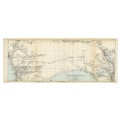
View AllGregory's 1861 Expedition into the North West of Australia, 1862
Located in Langweer, NL
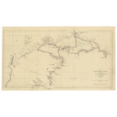
The map represents the route taken during F.T. Gregory's 1861 North West Australian Expedition.
This exploration was a significant journey that took place over the Pilbara region, starting from the Ashburton River and extending to the Dampier Archipelago and the De Grey...
Category
Antique 1860s Prints
Materials
Paper
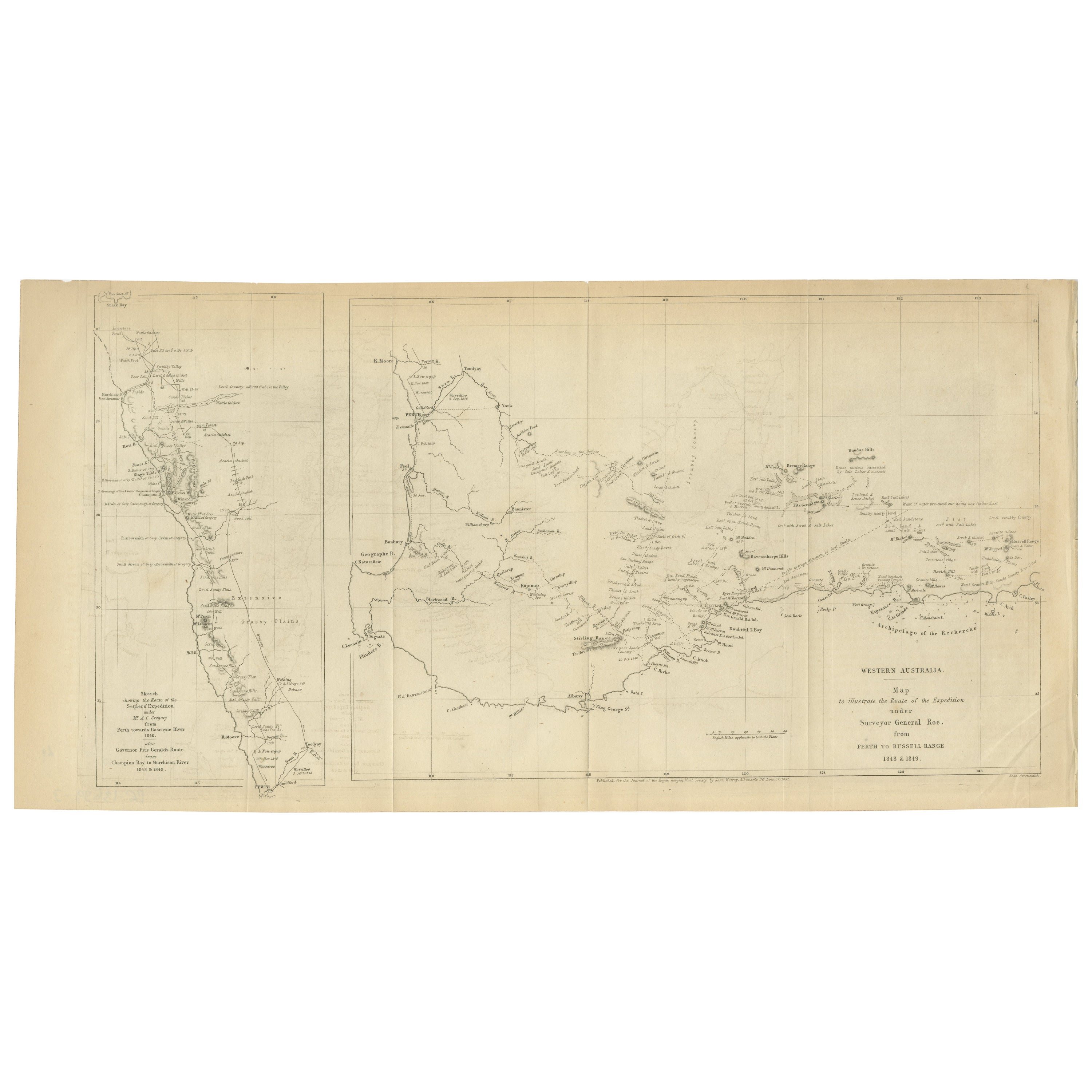
Charting the West: Surveyor General Roe’s Western Australian Expedition , 1852
Located in Langweer, NL
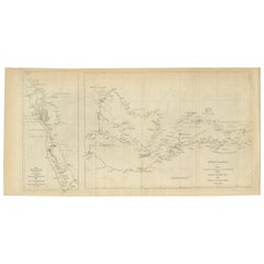
This map is a historical document, focused on Western Australia. It illustrates the route of an expedition under Surveyor General Roe from Perth to Russell Range during 1848 and 1849...
Category
Antique 1850s Prints
Materials
Paper
$277 Sale Price
20% Off
Free Shipping
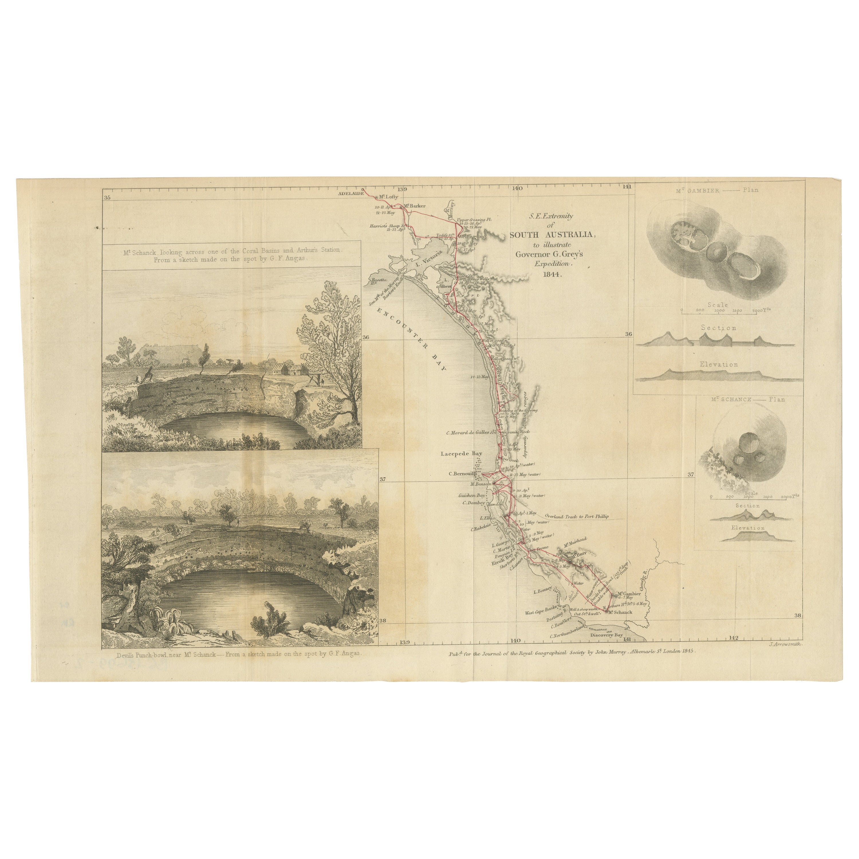
Traversing the Volcanic Frontier: A South Australian Expedition of 1844
Located in Langweer, NL
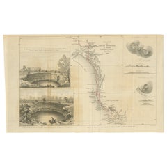
This is a historical document and part of a map and illustration from an expedition. The text indicates it is from South Australia to illustrate Governor G. Grey's Expedition in 1841...
Category
Antique 1840s Prints
Materials
Paper
$258 Sale Price
20% Off
Free Shipping
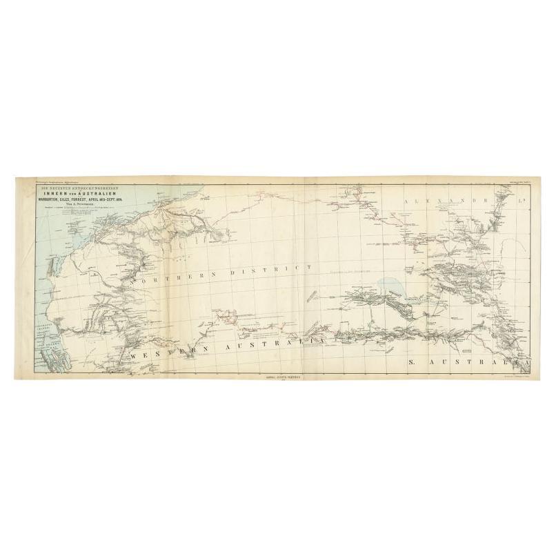
Antique Exploration Map of Australia from Sharks Bay to Alice Springs, 1876
Located in Langweer, NL
Antique map titled 'Die neuesten Entdeckungsreisen Innern von Australien von Warburton, Giles, Forrest (..)'. Old map of Australia from Sharks Bay to 90 Mile Beach over to Alice Springs...
Category
Antique 19th Century Maps
Materials
Paper
$239 Sale Price
20% Off
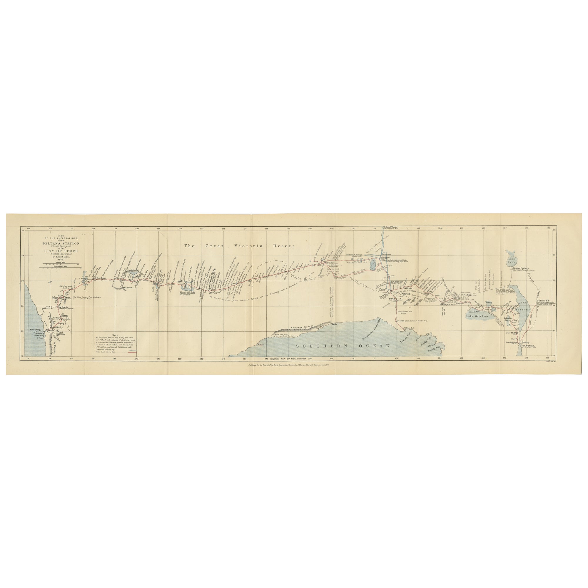
The 4000km Exploration of Ernest Giles from Beltena to Perth, Australia in 1875
Located in Langweer, NL
The map shows the route of the 1875 exploration led by Ernest Giles from Beltana Station in South Australia to the city of Perth in Western Australia. This was Giles' fourth and most...
Category
Antique 1870s Prints
Materials
Paper
$277 Sale Price
20% Off
Free Shipping
Antique Exploration Map of Australia from Beltana to Perth, 1876
Located in Langweer, NL
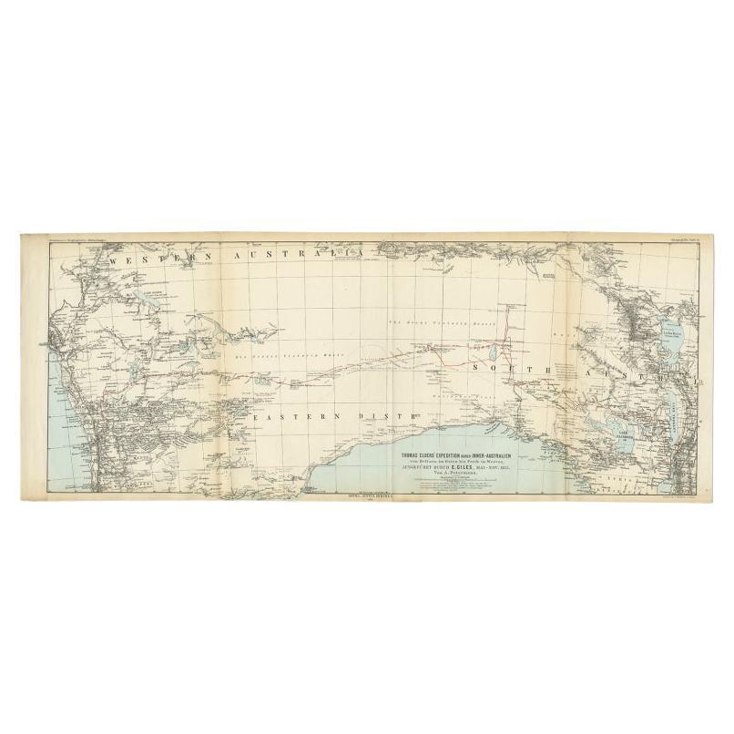
Antique map titled 'Thomas Elders' Expedition durch Inner-Australien von Beltana im Osten bis Perth im Western ausgefuhrt durch E. Giles (..)'. Old map of Australia from Bunbury to A...
Category
Antique 19th Century Maps
Materials
Paper
$239 Sale Price
20% Off
You May Also Like
Ancient National Atlas of France with Marengo
Located in Alessandria, Piemonte
Ancient National Atlas of France with the department of Marengo: a rare French etching dated 1806.
ST/178.
Category
Antique Early 19th Century French Other Prints
Materials
Paper

Original Antique Map of Australia by Dower, circa 1835
Located in St Annes, Lancashire
Nice map of Australia
Drawn and engraved by J.Dower
Published by Orr & Smith. C.1835
Unframed.
Free shipping
Category
Antique 1830s English Maps
Materials
Paper

Large Original Antique Map of Australia by Sidney Hall, 1847
Located in St Annes, Lancashire
Great map of Australia
Drawn and engraved by Sidney Hall
Steel engraving
Original colour outline
Published by A & C Black. 1847
Unframed
Free shipping.
Category
Antique 1840s Scottish Maps
Materials
Paper

Original Antique Map of Tasmania, Australia by Dower, circa 1835
Located in St Annes, Lancashire
Nice map of Tasmania
Drawn and engraved by J.Dower
Published by Orr & Smith. C.1835
Unframed.
Free shipping
Category
Antique 1830s English Maps
Materials
Paper

Australia, Tallis antique map, 1851
Located in Melbourne, Victoria
'Australia'
With decorative border surrounds and vignettes including a view of Sydney, Kangaroos, Natives of Australia Felix, Australian Parrots and Cockatoos and Natives of the Tri...
Category
19th Century Naturalistic Landscape Prints
Materials
Engraving

Original 1891 Walker Map
Located in Norwell, MA
Original 1891 map of Massachusetts by Walker. Towns include Cambridge, Boston, Dedham, Ashland, Brookline, Newton etc... burl wood frame. Measures...
Category
Antique 19th Century Maps

More Ways To Browse
In Australia
Antique Hara
Paul Evans Cityscape Cabinet
Perfume Cabinet
Persian Side Table
Pheasant Figure
Pill Box 800 Silver
Plaster Cherub
Psyche Bronze 19th Century French
Qing Dynasty Teapot
Quail Decorative Object
Quilted Maple
Rattan Bamboo Headboard
Regency Table Kogl
Rococo Fire Basket
Rosewood Breakfront
Saddle Horse Stand
San Remo