Items Similar to Antique Engravings of Mauritius and Indonesia, incl de Banda Islands, c.1730

Want more images or videos?
Request additional images or videos from the seller
1 of 6
Antique Engravings of Mauritius and Indonesia, incl de Banda Islands, c.1730
$527.01
$658.7620% Off
£390.54
£488.1820% Off
€440
€55020% Off
CA$719.46
CA$899.3320% Off
A$800.37
A$1,000.4720% Off
CHF 419.57
CHF 524.4620% Off
MX$9,780.36
MX$12,225.4520% Off
NOK 5,342.64
NOK 6,678.3020% Off
SEK 5,029.36
SEK 6,286.7020% Off
DKK 3,350.12
DKK 4,187.6520% Off
Shipping
Retrieving quote...The 1stDibs Promise:
Authenticity Guarantee,
Money-Back Guarantee,
24-Hour Cancellation
About the Item
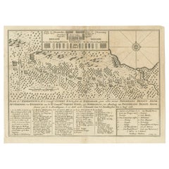
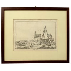
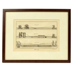
Title on page: "Ins. de Cerno a. Nostatibus Mauritius Nominata [on sheet with] Gunnanappi Labetacq [and] Civitas Gammelamme [and] Rex Tubatus", Le Clerc, Jean
This sheet includes four engravings, published in a history of Dutch exploration:
1. Top left: shows natives on Mauritius fishing and building a boat, with a dodo (extinct) and two turtles at right.
2. Top right: the Banda islands (also known as the Spice Islands) of Banda Api, Banda Neira and Banda Besar.
3. Bottom left: a procession for the king of Ternate in the town of Gamalama.
4, Bottom right: a procession for the king of Tuban, Java, riding an elephant.
Subject: Islands in Indonesia & Mauritius
Period: Circa 1730
Color: hand color
Size: 12.5 x 8.8 inches / 31.8 x 22.4 cm
A nice impression on a sheet with a leaf-shaped watermark, light toning along the centerfold, and light soiling mostly confined to the blank margins.
- Dimensions:Height: 8.82 in (22.4 cm)Width: 12.52 in (31.8 cm)Depth: 0 in (0.02 mm)
- Materials and Techniques:
- Period:1730-1739
- Date of Manufacture:circa 1730
- Condition:A nice impression on a sheet with a leaf-shaped watermark, light toning along the centerfold, and light soiling mostly confined to the blank margins.
- Seller Location:Langweer, NL
- Reference Number:Seller: BG-130681stDibs: LU3054326315752
About the Seller
5.0
Recognized Seller
These prestigious sellers are industry leaders and represent the highest echelon for item quality and design.
Platinum Seller
Premium sellers with a 4.7+ rating and 24-hour response times
Established in 2009
1stDibs seller since 2017
2,502 sales on 1stDibs
Typical response time: <1 hour
- ShippingRetrieving quote...Shipping from: Langweer, Netherlands
- Return Policy
Authenticity Guarantee
In the unlikely event there’s an issue with an item’s authenticity, contact us within 1 year for a full refund. DetailsMoney-Back Guarantee
If your item is not as described, is damaged in transit, or does not arrive, contact us within 7 days for a full refund. Details24-Hour Cancellation
You have a 24-hour grace period in which to reconsider your purchase, with no questions asked.Vetted Professional Sellers
Our world-class sellers must adhere to strict standards for service and quality, maintaining the integrity of our listings.Price-Match Guarantee
If you find that a seller listed the same item for a lower price elsewhere, we’ll match it.Trusted Global Delivery
Our best-in-class carrier network provides specialized shipping options worldwide, including custom delivery.More From This Seller
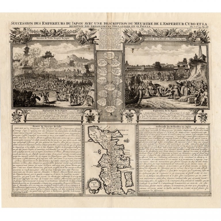
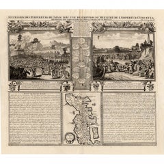
View AllAntique Engravings of Japan incl a Map and the Arrival of the Dutch, 1732
Located in Langweer, NL
Original antique print titled 'Succession des Empereurs du Japon avec une Description de Meurtre de l'Empereur Cubo et la Reception des Ambassadeurs Hollandois en ce Pays la'. It sho...
Category
Antique 18th Century Prints
Materials
Paper
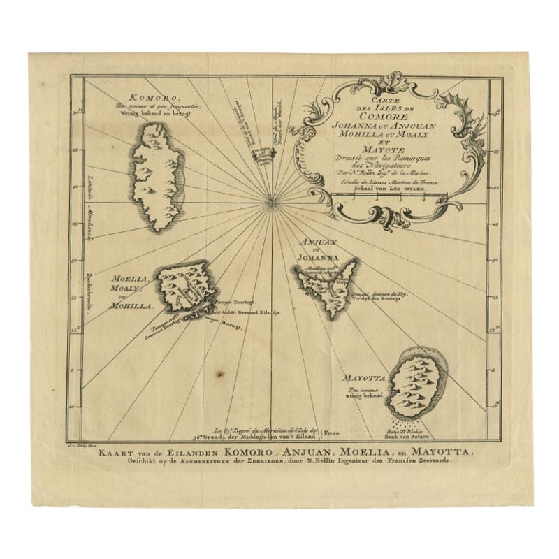
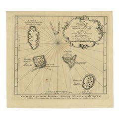
Comore Island Original Antique Engraving by Van Schley, 1749
Located in Langweer, NL
Antique map titled 'Carte des Isles de Comore Johanna ou Anouan Mohilla ou Moaly et Mayote (..) - Kaart van de Eilanden Komoro, Anjuan, Moelia, en Mayotta (..)'. Copper engraving of ...
Category
Antique 18th Century Maps
Materials
Paper
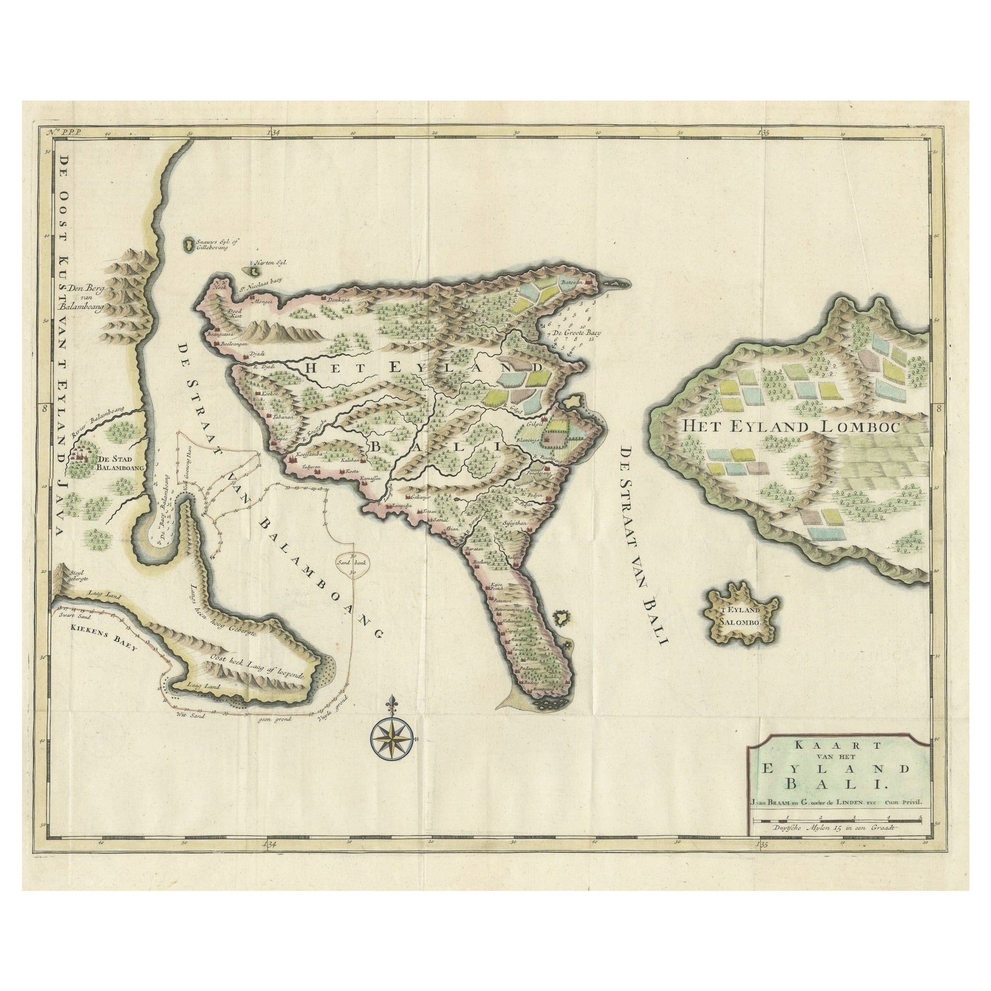
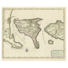
1726 Valentyn's Map of Bali and Lombok, Original Engraving
Located in Langweer, NL
This antique map is a detailed 18th-century chart of the island of Bali, one of the many islands of Indonesia, with an inset of the neighboring island Lombok, attributed to François ...
Category
Antique Early 18th Century Maps
Materials
Paper
$1,437 Sale Price
20% Off
Antique Print of the Expedition of Govert Knol from Surabaya to Pangerang, 1750
Located in Langweer, NL
Antique print titled 'Aftekening der Expeditie van de Hr. Commissaris Govert Cnoll uyt Soerabaja, tot afhalinge van Pangerang Adepati Anom'. Map showing the expedition of Commissione...
Category
Antique Mid-18th Century Prints
Materials
Paper
$114 Sale Price
20% Off
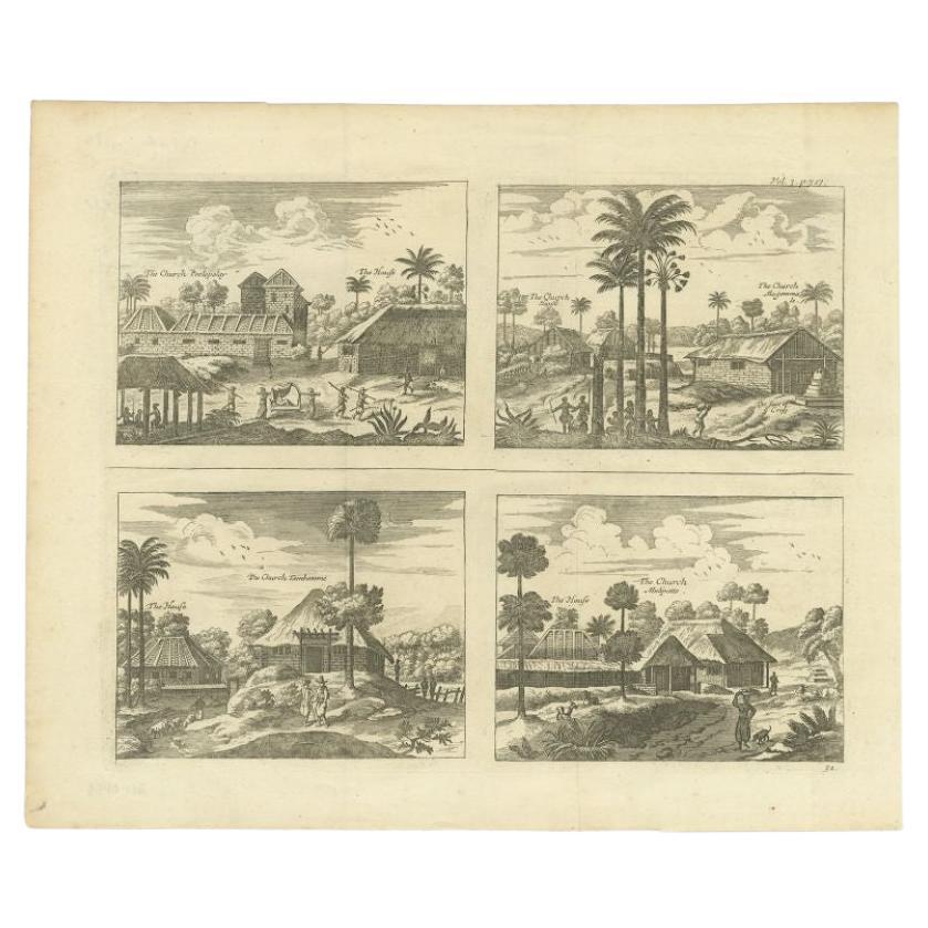
Original Antique Engravings of Various Churches on Ceylon 'Sri Lanka', 1732
Located in Langweer, NL
Antique print titled 'The Church Poelepolay, The Church Mogommate, The church Tambamme, the Church Mulipatto'. Antique print with four views of the churches of Poelepolay, Mogommate,...
Category
Antique 18th Century Prints
Materials
Paper
$287 Sale Price
20% Off
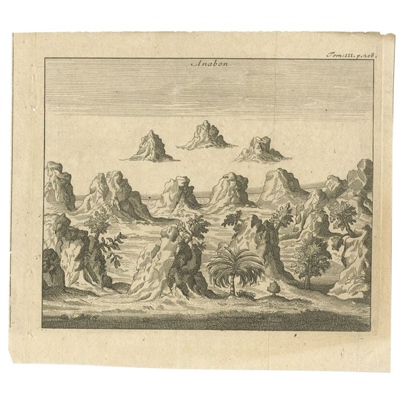
Antique Print of Ambon, Indonesia, c.1740
Located in Langweer, NL
Antique print Ambon titled 'Anabon'. Antique print of the island of Ambon, Indonesia. Source unknown, to be determined.
Artists and Engravers: Anonymous.
Condition: Good, gener...
Category
Antique 18th Century Prints
Materials
Paper
$93 Sale Price
20% Off
You May Also Like
Antique Voc Print Holland Malaysia Old Map Melaka History, 1663
Located in Amsterdam, Noord Holland
From my own collection I offer this impressive Antique print of the city of Malakka
A very interesting piece for collectors . It is an museum piece from the Dutch Institute of Orien...
Category
Antique 17th Century European Paintings
Materials
Paper

$293 Sale Price
20% Off
17th Century Italian Gravure, Theatrum Statuum Sabaudiae, circa 1682
By Joan (Johannes) Blaeu
Located in Miami, FL
17th century Italian Gravure/Cartography
Le Theatrum statuum Regiae Celsitudinis Sabaudiæ Ducis or at Theatrum Statum Sabaudiæ, is a representative and iconographic representation f...
Category
Antique 17th Century Italian Historical Memorabilia
Materials
Paper
$450 Sale Price
52% Off
Antique French Map of Asia Including China Indoneseia India, 1783
Located in Amsterdam, Noord Holland
Very nice map of Asia. 1783 Dedie au Roy.
Additional information:
Country of Manufacturing: Europe
Period: 18th century Qing (1661 - 1912)
Condition: Overall Condition B (Good Used)...
Category
Antique 18th Century European Maps
Materials
Paper

$648 Sale Price
20% Off
Engraving Print from the Panckoucke Encyclopédie Nautical Subject 1782-1832
Located in Milan, IT
Print by engraving on copper plate from the Panckoucke Encyclopédie méthodique, end of the 18th century,volume Marine Planches (more than 1,500 figures dealing with all subjects on the marina: planes, construction, carpentry, tree trunks, armaments of maneuvers, ropes, sails, artillery, ship maneuvers and combat tactics). This is the plate no. n. 24, pag. 69 fig. 341 ; with frame cm 38.3 x 31.5. Ship ropes are depicted. The Print has the "Benard direxit...
Category
Antique 1790s French Nautical Objects
Materials
Paper
Engraving Print from the Panckoucke Encyclopédie Nautical Subject, 1782-1832
Located in Milan, IT
Print by engraving on copper plate from the Panckoucke Encyclopédie méthodique, end of the 18th century, volume Marine Planches (more than 1,500 figures dealing with all subjects on the marina: planes, construction, carpentry, tree trunks, armaments of maneuvers, ropes, sails, artillery, ship maneuvers and combat tactics). This is the plate no. n. 26, pag. 70 fig. 350-353; with frame cm 38.3 x 31.5. Ship ropes are depicted. The Print has the "Benard direxit...
Category
Antique 1790s French Nautical Objects
Materials
Paper
Tabula Indiae Orientalis - Etching by Frederick de Wit - 1680ca
By Frederick de Wit
Located in Roma, IT
This double-page etching with contemporary coloring, entitled Tabula Indiae orientalis, was realized by the cartographer Frederick de Wit for the famous Atlas published in Amsterdam ...
Category
1680s Modern Figurative Prints
Materials
Etching

More Ways To Browse
Antique Fishing Collectables
Indonesian Elephant
Rex Light
Mauritius Antique Map
Relief Map
Antique Map Of Venice
Antique Map Of Georgia
Antique Nautical Charts
Hand Painted Antique Map
Antique Maps New Zealand
Antique Maps Persia
Map Railroad
Mariner Furniture
Vintage Glass Map
Antique Furniture Cyprus
Antique Linen Map
Caribbean Colonial Furniture
Antique Maps West Indies