Items Similar to Antique Map of Denmark by Münster '1588'


Want more images or videos?
Request additional images or videos from the seller
1 of 5
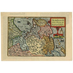
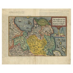
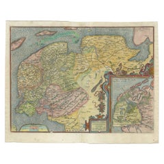
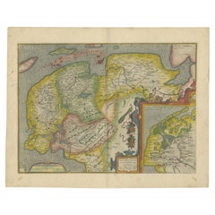
Antique Map of Denmark by Münster '1588'
$256.23
$320.2920% Off
£194.10
£242.6320% Off
€220
€27520% Off
CA$354.98
CA$443.7220% Off
A$398.13
A$497.6620% Off
CHF 208.49
CHF 260.6220% Off
MX$4,837.65
MX$6,047.0620% Off
NOK 2,647.52
NOK 3,309.4020% Off
SEK 2,510.04
SEK 3,137.5420% Off
DKK 1,675.03
DKK 2,093.7920% Off
About the Item
Antique map titled 'Beschreibung des Königreichs Dennmarck (..)'. Early map of Denmark. This map originates from 'Cosmographey Oder beschreibung Aller Länder (..)' by Sebastian Münster.
- Dimensions:Height: 12.6 in (32 cm)Width: 7.88 in (20 cm)Depth: 0.02 in (0.5 mm)
- Materials and Techniques:
- Period:
- Date of Manufacture:1588
- Condition:Original/contemporary hand coloring. General age-related toning, some wear. German text on verso, please study image carefully.
- Seller Location:Langweer, NL
- Reference Number:Seller: BG-12521-71stDibs: LU3054319679752
About the Seller
5.0
Recognized Seller
These prestigious sellers are industry leaders and represent the highest echelon for item quality and design.
Platinum Seller
Premium sellers with a 4.7+ rating and 24-hour response times
Established in 2009
1stDibs seller since 2017
2,517 sales on 1stDibs
Typical response time: <1 hour
- ShippingRetrieving quote...Shipping from: Langweer, Netherlands
- Return Policy
Authenticity Guarantee
In the unlikely event there’s an issue with an item’s authenticity, contact us within 1 year for a full refund. DetailsMoney-Back Guarantee
If your item is not as described, is damaged in transit, or does not arrive, contact us within 7 days for a full refund. Details24-Hour Cancellation
You have a 24-hour grace period in which to reconsider your purchase, with no questions asked.Vetted Professional Sellers
Our world-class sellers must adhere to strict standards for service and quality, maintaining the integrity of our listings.Price-Match Guarantee
If you find that a seller listed the same item for a lower price elsewhere, we’ll match it.Trusted Global Delivery
Our best-in-class carrier network provides specialized shipping options worldwide, including custom delivery.More From This Seller
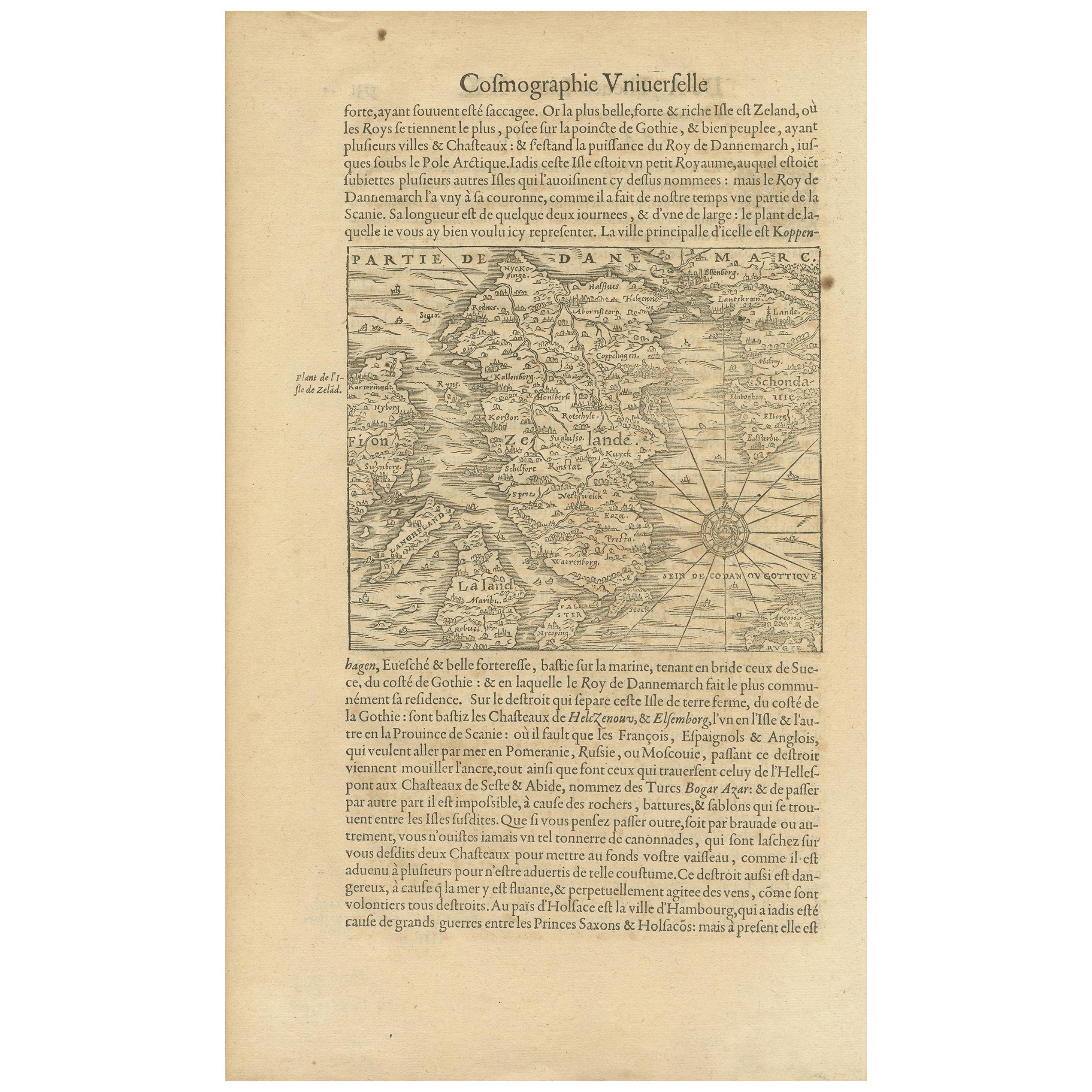
View AllAntique Map of the Island of Zealand 'Denmark' by Thevet, circa 1590
Located in Langweer, NL
Antique map titled 'Partie de Danemarc'. Map of the island of Zealand, Denmark, including the city of Copenhagen. This map originates from 'Cosmographie Universelle' by André Thevet.
Category
Antique 16th Century Maps
Materials
Paper
$256 Sale Price
20% Off
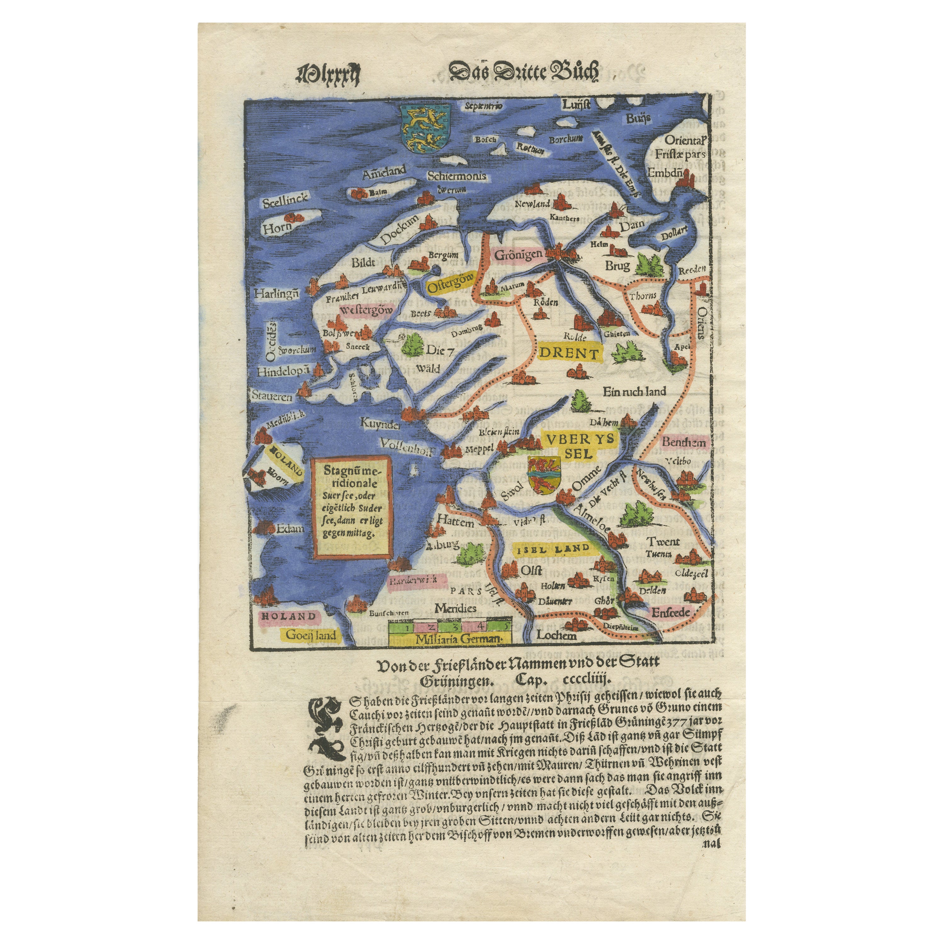
Friesland, Groningen, Drenthe, Overijssel – Antique Map by Seb. Münster, 1574
Located in Langweer, NL
Friesland, Groningen, Drenthe, Overijssel – Antique Map by Sebastian Münster, 1574
This rare and finely colored woodcut map of Northern Netherlands depicts the provinces of Friesl...
Category
Antique 16th Century Maps
Materials
Paper

Antique Map of Friesland 'The Netherlands' by J. Bussemacher, 1596
By Johann Bussemacher
Located in Langweer, NL
Beautiful hand-colored engraving of the province Friesland (The Netherlands). This map originates from the Atlas 'Europae totius orbis terrarium partis praestantissimae, universalis ...
Category
Antique 16th Century European Maps
Materials
Paper
$540 Sale Price
20% Off
Original Antique Map of Friesland in Decorative Hand-Colouring, 1600
Located in Langweer, NL
Antique map titled 'Frisiae antiquissima trans rhenu provinc et adiacentium regionum nova et exacta descriptio'. Original antique map of the province of Friesland, the Netherlands. T...
Category
Antique 17th Century Maps
Materials
Paper
$577 Sale Price
20% Off
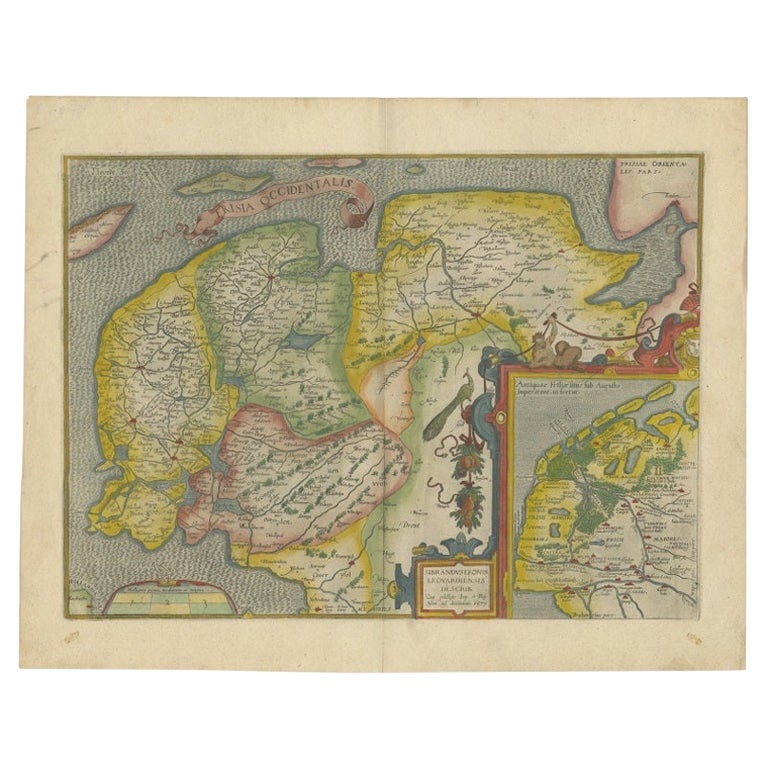
Old Antique Map of the Province of Friesland, the Netherlands, c.1580
Located in Langweer, NL
Antique map titled 'Frisia Occidentalis'. Old map of the province of Friesland, the Netherlands. This map is also known as the 'Pauwenkaart' ('peacock map'), referring to the peacock next to the inset map. Based on a manuscript map...
Category
Antique 16th Century Maps
Materials
Paper
$885 Sale Price
20% Off
Antique Map of Friesland Also Know as the Peacock Map, C.1580
Located in Langweer, NL
Antique map titled ?Frisia Occidentalis?. Original antique map of the province of Friesland, the Netherlands. Includes a fascinating inset of ancient Friesland with a peacock and myt...
Category
Antique 18th Century Maps
Materials
Paper
$1,537 Sale Price
20% Off
You May Also Like
17th Century Map of Denmark by French Cartographer Sanson, Dated 1658
By Nicolas Sanson
Located in Copenhagen, K
17th century map of Denmark by French cartographer Sanson.
Nicolas Sanson (20 December 1600-7 July 1667) was a French cartographer, termed by some the creator of French geography an...
Category
Antique 17th Century French Maps
Materials
Paper

Rugen Island, Germany: An Early 17th Century Map by Mercator and Hondius
By Gerard Mercator
Located in Alamo, CA
This is an early 17th century map entitled "Nova Famigerabilis Insulae Ac Ducatus Rugiae Desciptio" (Map of Rugen Island, Germany) by Gerard Mercator and Henricus and Joducus Hondiu...
Category
Early 17th Century Old Masters Landscape Prints
Materials
Engraving

1592 Abraham Ortelius Map "Lorraine: Lotharingiae Nova Descripti, Ric.A005
Located in Norton, MA
1592 Abraham Ortelius map entitled
"Lorraine: Lotharingiae Nova Descripti
Ric.a005
Description: Ortelius is best known for producing the atlas from which this map comes from, "...
Category
Antique 16th Century Dutch Maps
Materials
Paper

Map of the Netherlands - Etching by G. Braun and F. Hogenberg -Late 16th Century
By Franz Hogenberg
Located in Roma, IT
Map of the Netherlands is an original etching realized by George Braun and Franz Hogenberg, as part of the "Civitates Orbis Terrarum".
The “Civitates Orbis Terrarum” (Atlas of Citi...
Category
16th Century Figurative Prints
Materials
Etching

1590 Ortelius Map of Calais and Vermandois, France and Vicinity Ric.a014
Located in Norton, MA
1590 Ortelius map of
Calais and Vermandois, France and Vicinity
Ric.a014
Two rare regional Abraham Ortelius maps on a single folio sheet. Left map, entitled Caletensium, depic...
Category
Antique 16th Century Dutch Maps
Materials
Paper

1646 Jansson Map Entitled "Procinvia Connactiae, " Ric.a006
Located in Norton, MA
1646 Jansson map entitled
"Procinvia connactiae,"
Ric.a006
Description: The PROVINCE of CONNAVGT 490 x 380From vol 4 of Jansson's Atlas Novus 1646, published in Amsterdam with...
Category
Antique 17th Century Unknown Maps
Materials
Paper

More Ways To Browse
Denmark Map
Antique Map Denmark
Sebastian Munster
Indonesia Map
Antique Framed Map Engravings
Atlas Furniture Company
Used Office Furniture Edinburgh
Antique 16th Century Plates
Scotland Map
Antique Maps Indonesia
Map Of Japan
Antique Rollers
Compass Rose Antique
Dutch Empire
Swiss Antiques And Collectables
Antique Compass Map
Blaeu Maps
Coat Of Arms German