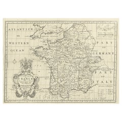
Items Similar to Antique Map of France with the English Channels, 1754


Want more images or videos?
Request additional images or videos from the seller
1 of 5
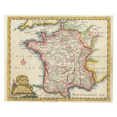
Antique Map of France with the English Channels, 1754
$233.04
$291.3020% Off
£175.75
£219.6920% Off
€200
€25020% Off
CA$322.20
CA$402.7420% Off
A$360.91
A$451.1420% Off
CHF 189.56
CHF 236.9620% Off
MX$4,388.59
MX$5,485.7420% Off
NOK 2,400.51
NOK 3,000.6420% Off
SEK 2,278.73
SEK 2,848.4120% Off
DKK 1,522.53
DKK 1,903.1620% Off
About the Item
Antique map France titled 'An Accurate Map of France drawn from the best authorities'. Small, detailed map of France. With decorative title cartouche.
Artists and Engravers: Emanuel Bowen (1694?-1767) was a British engraver and print seller.
Condition: Very good, please study image carefully.
Date: 1754
Overall size: 25 x 20.5 cm.
Image size: 22 x 18 cm.
- Dimensions:Height: 8.08 in (20.5 cm)Width: 9.85 in (25 cm)Depth: 0 in (0.01 mm)
- Materials and Techniques:
- Period:
- Date of Manufacture:1754
- Condition:
- Seller Location:Langweer, NL
- Reference Number:Seller: BG-093191stDibs: LU3054326191222
About the Seller
5.0
Recognized Seller
These prestigious sellers are industry leaders and represent the highest echelon for item quality and design.
Platinum Seller
Premium sellers with a 4.7+ rating and 24-hour response times
Established in 2009
1stDibs seller since 2017
2,517 sales on 1stDibs
Typical response time: <1 hour
- ShippingRetrieving quote...Shipping from: Langweer, Netherlands
- Return Policy
Authenticity Guarantee
In the unlikely event there’s an issue with an item’s authenticity, contact us within 1 year for a full refund. DetailsMoney-Back Guarantee
If your item is not as described, is damaged in transit, or does not arrive, contact us within 7 days for a full refund. Details24-Hour Cancellation
You have a 24-hour grace period in which to reconsider your purchase, with no questions asked.Vetted Professional Sellers
Our world-class sellers must adhere to strict standards for service and quality, maintaining the integrity of our listings.Price-Match Guarantee
If you find that a seller listed the same item for a lower price elsewhere, we’ll match it.Trusted Global Delivery
Our best-in-class carrier network provides specialized shipping options worldwide, including custom delivery.More From This Seller
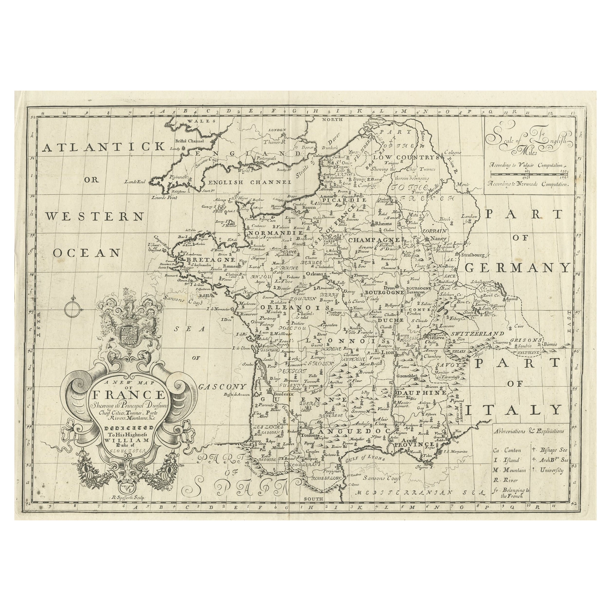
View AllAntique Map of France by British Mapmaker Wells, c.1710
Located in Langweer, NL
Antique map titled 'A New Map of France (..)'.
Original antique map of France. It covers all of France and parts of Belgium and Switzerland. This map originates from 'A new sett ...
Category
Antique 18th Century Maps
Materials
Paper
$335 Sale Price
20% Off
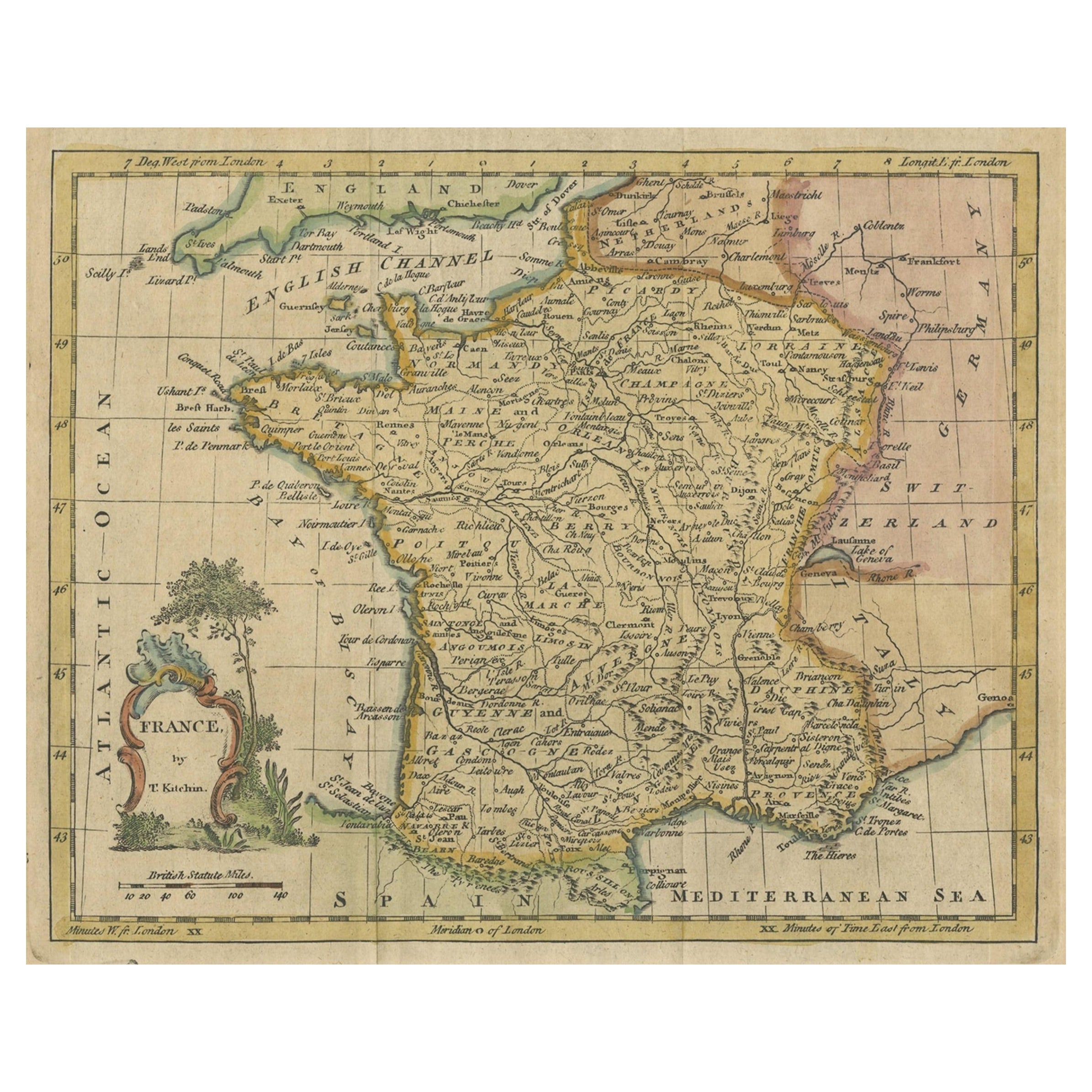
Antique Map of France with a Nice Cartouche of a Distance Scale, c.1756
Located in Langweer, NL
Antique map titled 'France'. Engraved map of France with a small, decorative title cartouche and distance scale. Originates from 'A New Geographical and Historical Grammar (..)', by ...
Category
Antique 18th Century Maps
Materials
Paper
$256 Sale Price
20% Off
Antique Map of France by Mortier 'c.1710'
Located in Langweer, NL
Antique map titled 'Gallia vetus ex C. Iulii Caesaris (..)'. Original antique map of France. Published by P. Mortier, c.1710.
Category
Antique Early 18th Century Maps
Materials
Paper

$943 Sale Price
20% Off
Homann Heirs Map of France – Antique Hand-Colored, circa 1745
Located in Langweer, NL
Antique map titled 'Gallia Postarum geographice designata in qua Cursus Postarum Secundum Statum (..)'. Unusual postal map of France, with coat of arms. Very detailed map showing all...
Category
Antique Mid-18th Century German Maps
Materials
Paper

$377 Sale Price
20% Off
Antique Map of France by Mortier 'c.1730'
Located in Langweer, NL
Antique map titled 'Galliae Antiquae Tabula'. Original antique map of France in ancient times. Published by P. Mortier, circa 1730.
Category
Antique Mid-18th Century Maps
Materials
Paper

$1,048 Sale Price
25% Off
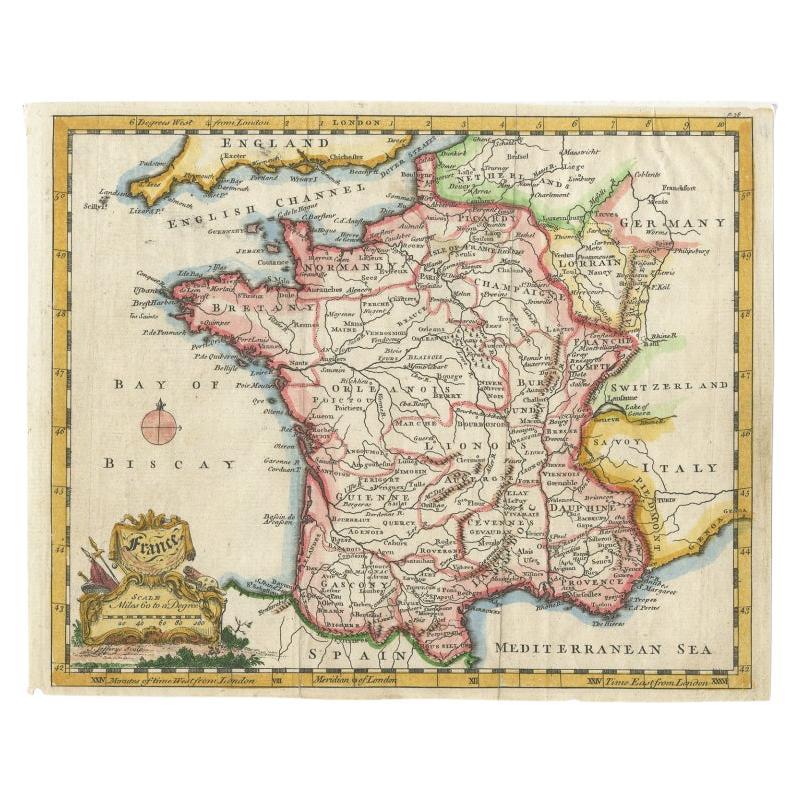
Antique Map of France by Kitchin, c.1770
Located in Langweer, NL
Antique map titled 'France'. Original antique map of France. Source unknown, to be determined.
Artists and Engravers: Thomas Kitchin (or Thomas Kitchen (1718 - 1784) was an Englis...
Category
Antique 18th Century Maps
Materials
Paper

You May Also Like
The Normandy Region of France: A 17th C. Hand-colored Map by Sanson and Jaillot
By Nicolas Sanson
Located in Alamo, CA
This large hand-colored map entitled "Le Duché et Gouvernement de Normandie divisée en Haute et Basse Normandie en divers Pays; et par evêchez, avec le Gouvernement General du Havre ...
Category
Antique 1690s French Maps
Materials
Paper

1714 Henri Chatelain "Nouvelle Carte Des Etatas Du Grand.Duc De Mos Moscovie Eur
Located in Norton, MA
A 1714 Henri Chatelain map, entitled
"Nouvelle Carte Des Etatas Du Grand Duc De Moscovie En Europe,"
Ricb001
Henri Abraham Chatelain (1684-1743) was a Huguenot pastor of Parisi...
Category
Antique Early 18th Century Dutch Maps
Materials
Paper

1771 Bonne Map of Poitou, Touraine and Anjou, France, Ric.a015
Located in Norton, MA
1771 Bonne Map of Poitou,
Touraine and Anjou, France
Ric.a015
1771 Bonne map of Potiou, Touraine and Anjou entitled "Carte des Gouvernements D'Anjou et du Saumurois, de la Touraine, du Poitou,du Pays d'aunis, Saintonge?Angoumois,"
Carte des gouvernements d'Anjou et du Saumurois, de la Touraine, du Poitou, du Pays d'Aunis, Saintonge-Angoumois. Projettee et assujettie au ciel par M. Bonne, Hyd. du Roi. A Paris, Chez Lattre, rue St. Jacques a la Ville de Bord(ea)ux. Avec priv. du Roi. 1771. Arrivet inv. & sculp., Atlas moderne ou collection de cartes sur toutes...
Category
Antique 17th Century Unknown Maps
Materials
Paper

Map Holy Land La Terre Sainte Engraved van Loon Published N de Fer 1703 French
Located in BUNGAY, SUFFOLK
La Terre Sainte, The Holy Land, Tiree Des Memoires De M.De.La Rue. Par N. de Fer. Geographe de Sa Majeste Catoliq et de Monseigneur le Dauphin. Avec Privil du Roi 1703
Detailed map of the Holy Land from Nicholas de Fer's L'Atlas Curieux ou le Monde. East is oriented at the top.
MAKER Nicolas de Fer 1646-1720
The French cartographer and engraver, Nicolas de Fer, was a master at creating maps that were works of art. The maps that he published were printed during the Baroque period when the decorative arts were characterized by ornate detail. De Fer’s detailed maps and atlases were valued more for their decorative content than their geographical accuracy.
Nicolas de Fer was born in 1646. His father, Antoine de Fer, owned a mapmaking firm. At the age of twelve, Nicolas was apprenticed to a Parisian engraver named Louis Spirinx. The family business was starting to decline when his father died in 1673. Nicolas de Fer’s mother, Genevieve, took over the business after the death of her husband. In 1687 the business was passed on to Nicolas and the profits increased after he took over the firm. Nicolas de Fer was a prolific cartographer who produced atlases and hundreds of single maps. He eventually became the official geographer to King Louis XIV of France and King Philip V...
Category
Antique Early 1700s French Louis XIV Maps
Materials
Paper

1640 Joan Bleau Map Entitled"Diocecese de rheims et le pais de rethel, " Eic.a011
Located in Norton, MA
1640 Joan Bleau map entitled
"Diocecese de rheims et le pais de rethel,"
Ric.a011
OAN BLAEU
Diocecese de Rheims, et le pais de Rethel.
Handcolored engraving, c.1640.
...
Category
Antique 17th Century Dutch Maps
Materials
Paper

1752 Vaugoundy Map of Flanders : Belgium, France, and the Netherlands, Ric.a002
Located in Norton, MA
Large Vaugoundy Map of Flanders:
Belgium, France, and the Netherlands
Colored -1752
Ric.a002
Description: This is a 1752 Didier Robert de Vaugondy map of Flanders. The map de...
Category
Antique 17th Century Unknown Maps
Materials
Paper

More Ways To Browse
Antique Railroad Collectibles
Blaeu World Map
Roman Empire Map
Antique Map Of Middle East
Caribbean Map
Antique Map Of Egypt
Antique Map Ortelius
Antique Farm Antiques Collectibles
Antique Galleon
Biblical Maps
Medieval Capital
Civil War Map
Map Of Singapore
Migeon Migeon
Scottish Coat Of Arms
Antique Maps Of Canada
Antique Railroad Maps
Relief Map