Items Similar to Antique Map of France by British Mapmaker Wells, c.1710


Want more images or videos?
Request additional images or videos from the seller
1 of 6
Antique Map of France by British Mapmaker Wells, c.1710
About the Item
Antique map titled 'A New Map of France (..)'.
Original antique map of France. It covers all of France and parts of Belgium and Switzerland. This map originates from 'A new sett of maps both of antient and present Geography (..)' by Edward Wells. Artists and Engravers: Edward Wells (1667?1727) was an English mathematician, geographer, and controversial theologian.
Artist: Edward Wells (1667?1727) was an English mathematician, geographer, and controversial theologian.
Condition: Fair/good, general age-related toning. Original folding line, small defect near 'Rochfort'. Minor wear, blank verso. Please study image carefully.
Date: c.1710
We sell original antique maps to collectors, historians, educators and interior decorators all over the world. Our collection includes a wide range of authentic antique maps from the 16th to the 20th centuries. Buying and collecting antique maps is a tradition that goes back hundreds of years. Antique maps have proved a richly rewarding investment over the past decade, thanks to a growing appreciation of their unique historical appeal. Today the decorative qualities of antique maps are widely recognized by interior designers who appreciate their beauty and design flexibility. Depending on the individual map, presentation, and context, a rare or antique map can be modern, traditional, abstract, figurative, serious or whimsical. We offer a wide range of authentic antique maps for any budget.
- Dimensions:Height: 18.12 in (46 cm)Width: 21.26 in (54 cm)Depth: 0 in (0.01 mm)
- Materials and Techniques:
- Period:
- Date of Manufacture:circa 1710
- Condition:
- Seller Location:Langweer, NL
- Reference Number:
About the Seller
5.0
Platinum Seller
These expertly vetted sellers are 1stDibs' most experienced sellers and are rated highest by our customers.
Established in 2009
1stDibs seller since 2017
1,919 sales on 1stDibs
Typical response time: <1 hour
- ShippingRetrieving quote...Ships From: Langweer, Netherlands
- Return PolicyA return for this item may be initiated within 14 days of delivery.
More From This SellerView All
- Antique Map of France by Mortier 'c.1710'Located in Langweer, NLAntique map titled 'Gallia vetus ex C. Iulii Caesaris (..)'. Original antique map of France. Published by P. Mortier, c.1710.Category
Antique Early 18th Century Maps
MaterialsPaper
- Antique Map of the Coast of France, 1710By Jacobus HarrewijnLocated in Langweer, NLAntique map titled 'Les Embouchures de la Somme et de Bresle'. Map of the coast of Northern France showing the estuaries of the Somme and the Bresle. This map is part of a serie of...Category
Antique Early 18th Century Maps
MaterialsPaper

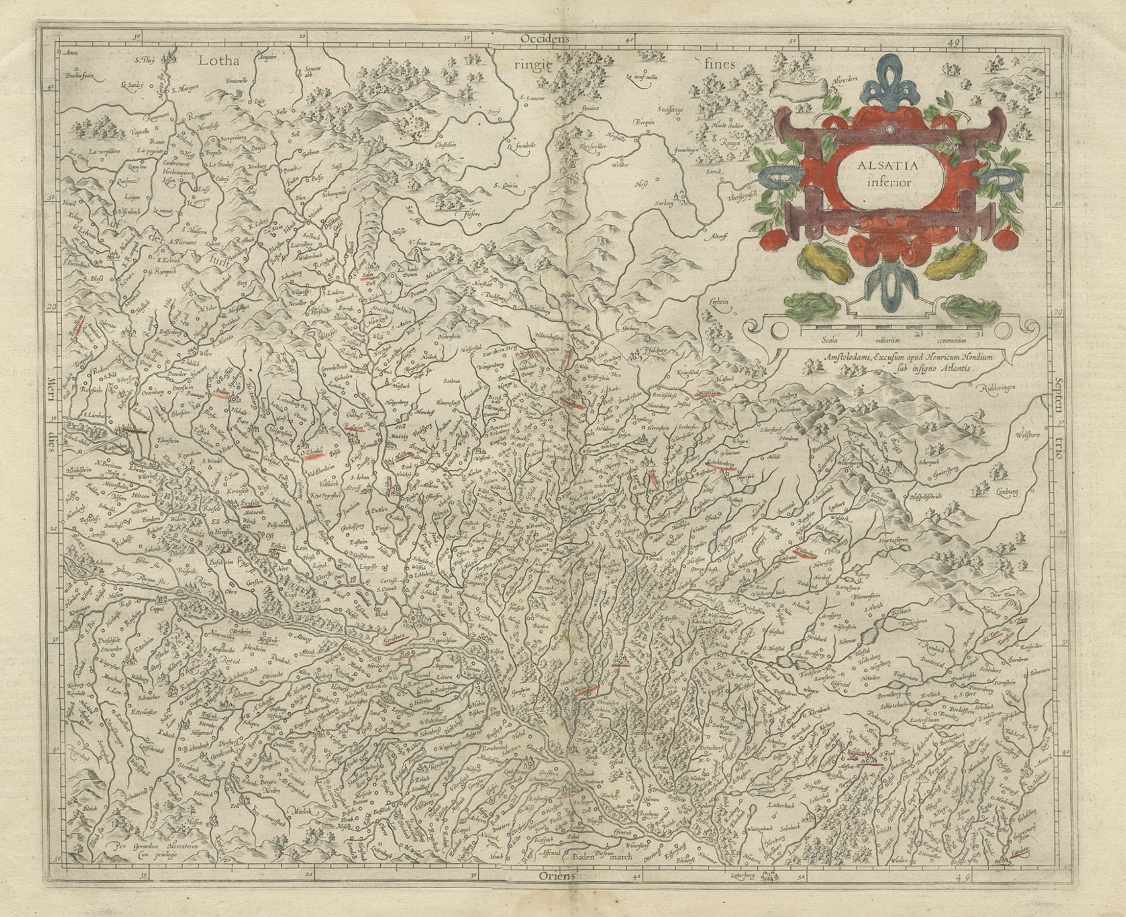
- Antique Map of the Lower Alsace Region of France by Mapmaker Hondius, c.1630Located in Langweer, NLAntique map titled 'Alsatia Inferior'. Original antique map of the northern Alsace (Elzas) region of France. The map is centered on the course of the Rhine River, with Strasbourg at ...Category
Antique 17th Century Maps
MaterialsPaper
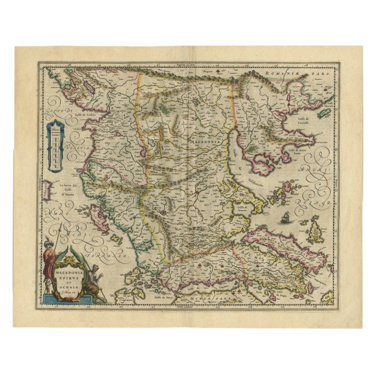
- Antique Map of Macedonia by the Famous Mapmaker Blaeu, c.1650Located in Langweer, NLAntique map titled 'Macedonia, Epirus et Achaia'. Ornated with a nice allegoric cartouche, one ship and a milage scale. Macedonia is shown in the centre of the map. With many detai...Category
Antique 17th Century Maps
MaterialsPaper
- Antique Map of Southeast Asia by J. Ottens, 1710Located in Langweer, NLAntique map titled 'Le Royaume de Siam avec Les Royaumes Qui Luy sont Tributaries'. Influential map of Southeast Asia. Ottens incorporated information provided by the French Jesuits ...Category
Antique Early 18th Century Maps
MaterialsPaper
- Antique Map of Essex by Overton, circa 1710Located in Langweer, NLAntique map titled 'Essex, devided into Hundreds, with the most antient and fayre Towne Colchester (..)'. Map of Essex, England. Includes an inset town pl...Category
Antique Early 18th Century Maps
MaterialsPaper


You May Also Like
- England, Scotland & Ireland: A Hand Colored Map of Great Britain by TirionBy Isaak TirionLocated in Alamo, CAThis is a hand-colored double page copperplate map of Great Britain entitled "Nieuwe Kaart van de Eilanden van Groot Brittannien Behelzende de Kon...Category
Antique Mid-18th Century Dutch Maps
MaterialsPaper
- Antique Map of Italy by Andriveau-Goujon, 1843By Andriveau-GoujonLocated in New York, NYAntique Map of Italy by Andriveau-Goujon, 1843. Map of Italy in two parts by Andriveau-Goujon for the Library of Prince Carini at Palazzo Carini i...Category
Antique 1840s French Maps
MaterialsLinen, Paper
- Antique Map of Principality of MonacoBy Antonio Vallardi EditoreLocated in Alessandria, PiemonteST/619 - "Old Geographical Atlas of Italy - Topographic map of ex-Principality of Monaco" - ediz Vallardi - Milano - A somewhat special edition ---Category
Antique Late 19th Century Italian Other Prints
MaterialsPaper
- Original Antique Map of Russia By Arrowsmith. 1820Located in St Annes, LancashireGreat map of Russia Drawn under the direction of Arrowsmith Copper-plate engraving Published by Longman, Hurst, Rees, Orme and Brown, 1820 Unframed.Category
Antique 1820s English Maps
MaterialsPaper
- Original Antique Map of Sweden, Engraved by Barlow, 1806Located in St Annes, LancashireGreat map of Sweden Copper-plate engraving by Barlow Published by Brightly & Kinnersly, Bungay, Suffolk. 1806 Unframed.Category
Antique Early 1800s English Maps
MaterialsPaper
- Original Antique Map of Belgium by Tallis, Circa 1850Located in St Annes, LancashireGreat map of Belgium Steel engraving Many lovely vignettes Published by London Printing & Publishing Co. ( Formerly Tallis ), C.1850 Origin...Category
Antique 1850s English Maps
MaterialsPaper


Recently Viewed
View AllMore Ways To Browse
16th Century English Antique
Rare Map France
Antique English Maps
Belgium Map
Antique French 18th Century Map
Antique British Maps
Antique Maps Of Britain
Antique Map Fair
World Map British
Swiss Antiques And Collectables
Antique Britain Map
Antique Map Britain
Map Of Belgium
Antique Map Switzerland
Belgium Antique Map
Antique Map Of Switzerland
Antique And Collectable Fairs
Antique Maps Amsterdam