Items Similar to Antique Map of Paraguay by A. Montanus, circa 1671

Want more images or videos?
Request additional images or videos from the seller
1 of 5
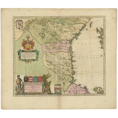
Antique Map of Paraguay by A. Montanus, circa 1671
$566.07
$707.5820% Off
£423.72
£529.6420% Off
€480
€60020% Off
CA$779.07
CA$973.8420% Off
A$868.36
A$1,085.4420% Off
CHF 455.60
CHF 569.5020% Off
MX$10,604.04
MX$13,255.0420% Off
NOK 5,768.84
NOK 7,211.0520% Off
SEK 5,452.43
SEK 6,815.5420% Off
DKK 3,654.10
DKK 4,567.6220% Off
About the Item
Antique map titled 'Paraquaria Vulgo Paraguay Cum adjacentibus'. Antique map extending from Rio de Janiero to the Rio de la Plata basin. The map includes Uruguay, Paraguay, part of northern Argentina and northern Chili.
- Creator:Arnoldus Montanus (Artist)
- Dimensions:Height: 12.13 in (30.8 cm)Width: 15.67 in (39.8 cm)Depth: 0.02 in (0.5 mm)
- Materials and Techniques:
- Period:Mid-17th Century
- Date of Manufacture:circa 1671
- Condition:Wear consistent with age and use. Few tiny marginal tears, please study images carefully.
- Seller Location:Langweer, NL
- Reference Number:Seller: BG-117251stDibs: LU3054314081041
About the Seller
5.0
Recognized Seller
These prestigious sellers are industry leaders and represent the highest echelon for item quality and design.
Platinum Seller
Premium sellers with a 4.7+ rating and 24-hour response times
Established in 2009
1stDibs seller since 2017
2,513 sales on 1stDibs
Typical response time: <1 hour
- ShippingRetrieving quote...Shipping from: Langweer, Netherlands
- Return Policy
Authenticity Guarantee
In the unlikely event there’s an issue with an item’s authenticity, contact us within 1 year for a full refund. DetailsMoney-Back Guarantee
If your item is not as described, is damaged in transit, or does not arrive, contact us within 7 days for a full refund. Details24-Hour Cancellation
You have a 24-hour grace period in which to reconsider your purchase, with no questions asked.Vetted Professional Sellers
Our world-class sellers must adhere to strict standards for service and quality, maintaining the integrity of our listings.Price-Match Guarantee
If you find that a seller listed the same item for a lower price elsewhere, we’ll match it.Trusted Global Delivery
Our best-in-class carrier network provides specialized shipping options worldwide, including custom delivery.More From This Seller
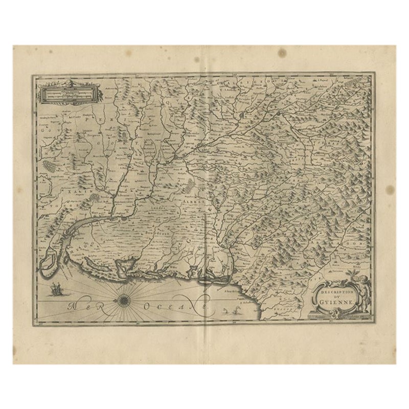
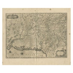
View AllAntique Map of the Region of Guyenne by Janssonius, 1657
By Johannes Janssonius
Located in Langweer, NL
Antique map of France titled 'Description du Guienne'. Decorative map of Guyenne region. Guyenne or Guienne was an old French province which corresponded roughly to the Roman provinc...
Category
Antique 17th Century Maps
Materials
Paper
$337 Sale Price
20% Off
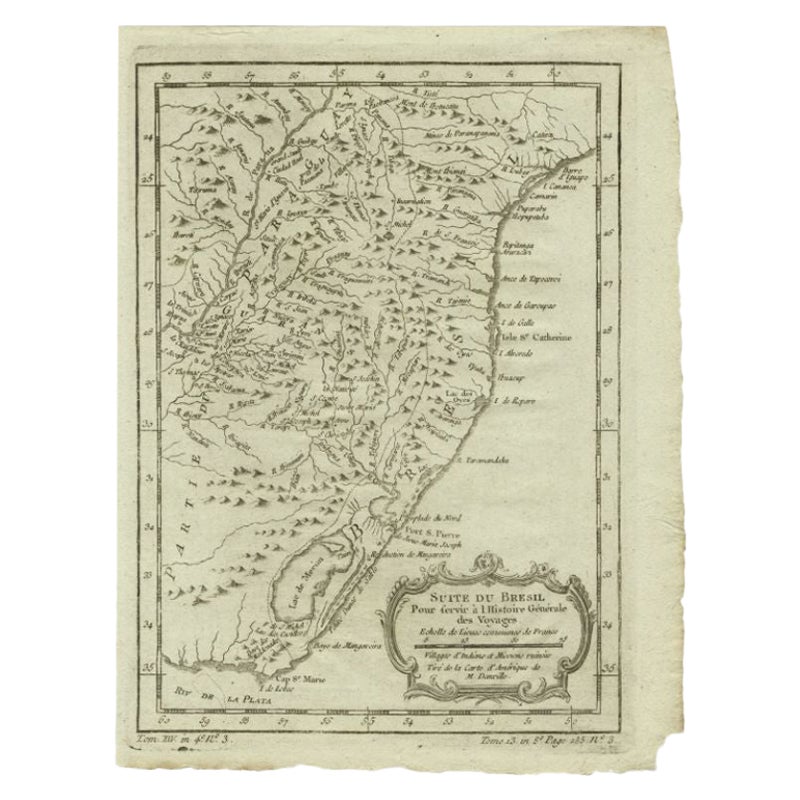
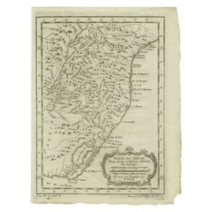
Antique Map of the Coast of Southern Brazil by Bellin, c.1755
By Jacques-Nicolas Bellin
Located in Langweer, NL
Antique map titled ‘Suite de Bresil’. Map of the coast of southern Brazil, with Lagoa Mirim, and Uruguay (here named as Paraguay). This print originates from 'Histoire générale des V...
Category
Antique 18th Century Maps
Materials
Paper
$92 Sale Price
20% Off
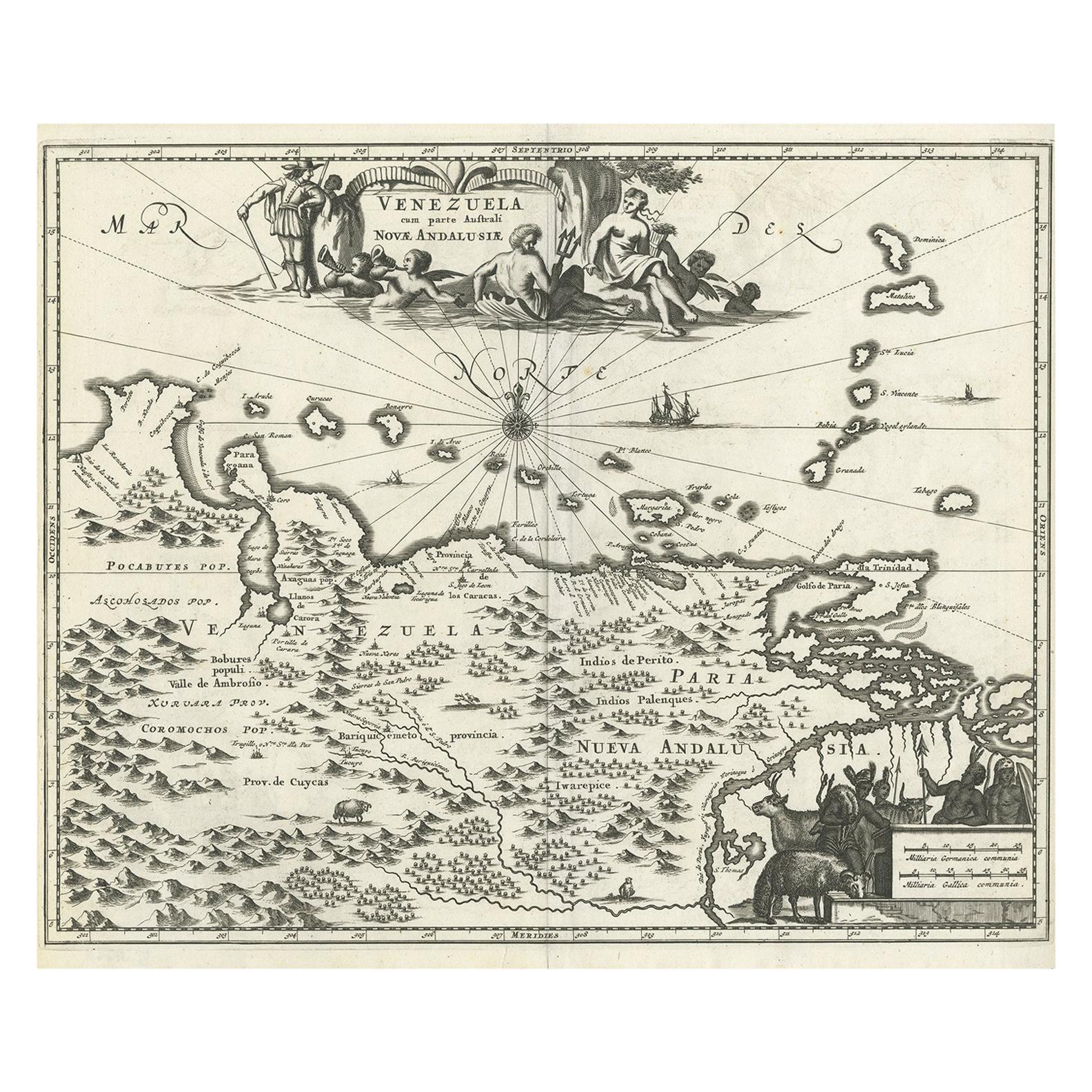
Antique Map of Venezuela by Montanus, 1671
By Arnoldus Montanus
Located in Langweer, NL
Antique map titled 'Venezuela cum parte Australi Novae Andalusiae'. The map extends from Coquibocoa to the Orinoque River, centered on Bariquicemento and Cape de Curiacao. Large cart...
Category
Antique Mid-17th Century English Maps
Materials
Paper
$566 Sale Price
20% Off
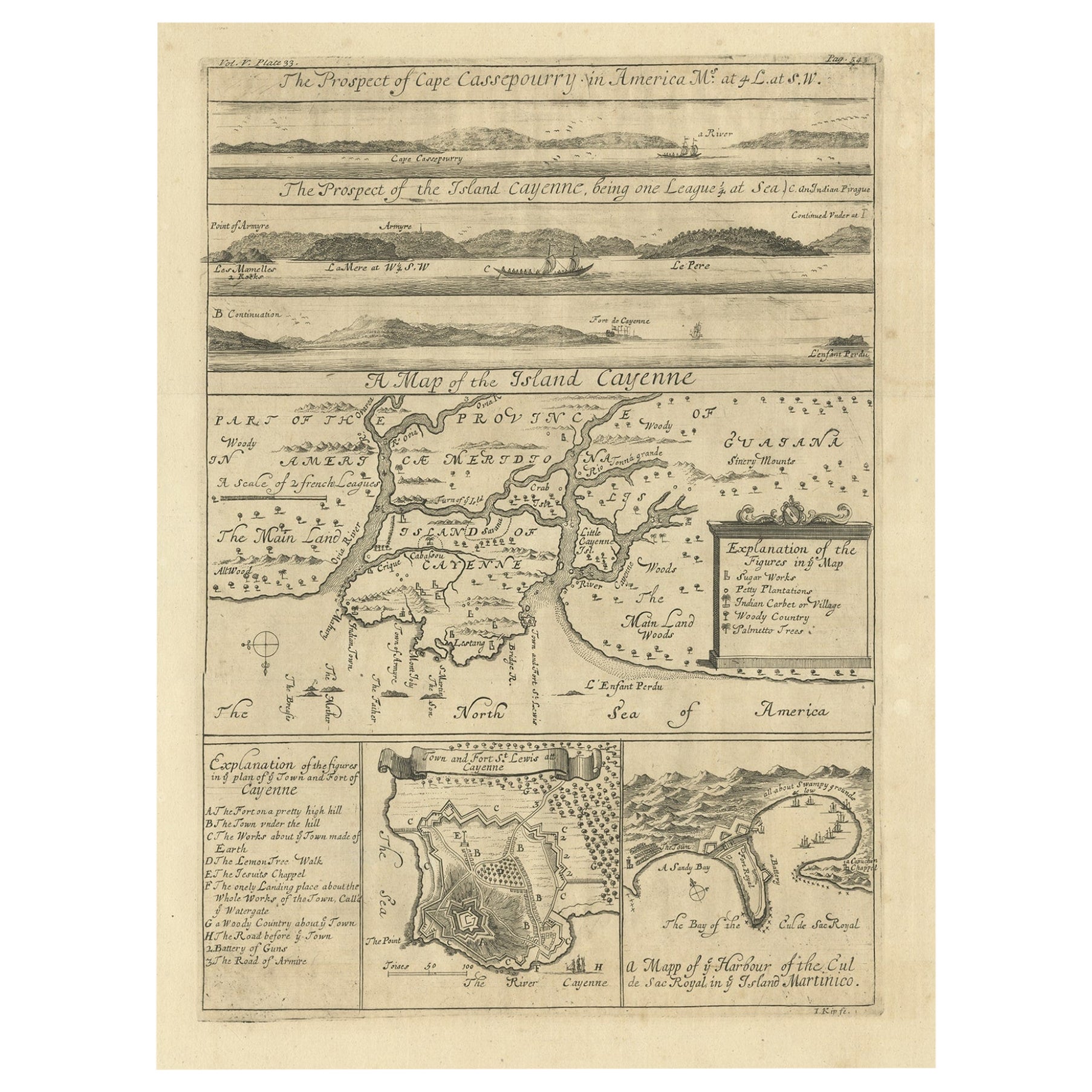
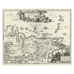
Antique Map of Cayenne and Cassepouri, French Guinea, South America, c.1730
Located in Langweer, NL
Antique map titled 'A Map of the Island Cayenne (..)’. A set of interesting copper engravings of Cayenne and Cassepouri, French Guinea, South America, and Martinique in the West Indies. The map of Cayenne, home of Cayenne pepper, has a key of symbols identifying the sugar works, petty plantations, indian carbet or village, woody country and palmetto trees. The plan of Fort Lewis, Cayenne also has a lettered key including; A. the fort on a pretty high hill...
Category
Antique 18th Century Maps
Materials
Paper
$358 Sale Price
20% Off
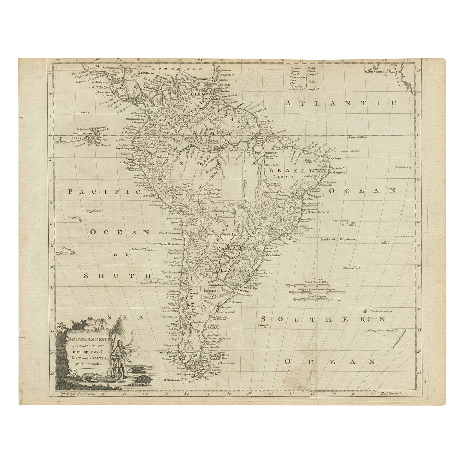
Rare Map of South America of Chili, La Plata, Paraguay, Brazil, Peru, c.1775
Located in Langweer, NL
Antique map titled 'South America agreeable to the most approved maps and charts'.
Rare map of South America depicting Chili, La Plata, Paraguay, Brazil, ...
Category
Antique 1770s Maps
Materials
Paper

$509 Sale Price
20% Off
Antique Map of Central Sweden by J. Blaeu, 1662
Located in Langweer, NL
A striking, rare map with a cartouche dedicated to Gabriel Bengtsson Oxenstierna. Published by J. Bleau, Amsterdam, 1662. Contemporary coloring.
Category
Antique Mid-17th Century Maps
Materials
Paper
$863 Sale Price
20% Off
You May Also Like
1654 Joan Blaeu Map the Sutherland, Scotland, Entitled "Southerlandia, "Ric0007
Located in Norton, MA
1654 Joan Blaeu map of the
Sutherland, Scotland, entitled
"Southerlandia,"
Hand Colored
Ric0007
Description:
Lovely map centered on Sedan and D...
Category
Antique 17th Century Dutch Maps
Materials
Paper

1627 Hendrik Hondius Map Entitled "Vltoniae Orientalis Pars, " Ric.a009
Located in Norton, MA
1627 Hendrik Hondius map entitled
"Vltoniae orientalis pars,"
Ric.a009
Title:
Vltoniae orientalis : pars
Title (alt.) :
Ultoniae orientalis pars
Creator:
Mercator, Gerh...
Category
Antique 17th Century Dutch Maps
Materials
Paper

Southerlandia Map - Etching by Johannes Janssonius - 1650
By Johannes Janssonius
Located in Roma, IT
Southerlandia Map is an ancient map realized in 1650 by Johannes Janssonius (1588-1664).
The Map is Hand-colored etching, with coeval watercoloring.
Good conditions.
From Atlantis...
Category
1650s Modern Figurative Prints
Materials
Etching

1640 Willem Blaeu Map Entitled "Contado di molise et principato vltra, " Ric.a003
By Willem Blaeu
Located in Norton, MA
1640 Willem Blaeu map entitled
"Contado di molise et principato vltra,"
Colored
Ric. a003
Measures: 38 x 49.6 cm and wide margins
DBLAEU.
Cou...
Category
Antique 17th Century Dutch Maps
Materials
Paper

Antique Map - Mar Di Athiopia - Etching by Johannes Janssonius - 1650s
By Johannes Janssonius
Located in Roma, IT
Antique Map - Mar Di Athiopia is an antique map realized in 1650 by Johannes Janssonius (1588-1664).
The Map is Hand-colored etching, with coeval watercolorang.
Good conditions wit...
Category
1650s Modern Figurative Prints
Materials
Etching

Antique Map - Gallia - Etching by Johannes Janssonius - 1650s
By Johannes Janssonius
Located in Roma, IT
Antique Map - Gallia is an antique map realized in 1650 by Johannes Janssonius (1588-1664).
The Map is Hand-colored etching, with coeval watercoloring.
Good conditions with slight ...
Category
1650s Modern Figurative Prints
Materials
Etching

More Ways To Browse
Antique Map Of Argentina
Antique English Maps
Map Of India
British Empire Furniture
American West Antiques
Furniture Russian 18th Century
Antique Law Office Furniture
Map Stand
Antique Maps Of Italy
Antique Doctors
Antique Map India
Antique Topographic Maps
Antique Railroad
Antique Maps Of Africa
Railroad Furniture
Antiques Compasses
Antique House Plans
Antique Navigation