Items Similar to Antique Physical Chart of the Atlantic Ocean by Johnston '1850'
Want more images or videos?
Request additional images or videos from the seller
1 of 5
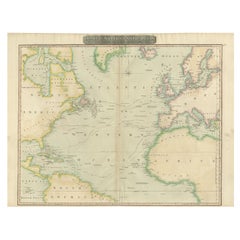
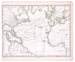
Antique Physical Chart of the Atlantic Ocean by Johnston '1850'
$191.64
$239.5520% Off
£142.01
£177.5220% Off
€160
€20020% Off
CA$261.62
CA$327.0320% Off
A$291.04
A$363.8120% Off
CHF 152.57
CHF 190.7120% Off
MX$3,556.49
MX$4,445.6220% Off
NOK 1,942.78
NOK 2,428.4720% Off
SEK 1,828.86
SEK 2,286.0720% Off
DKK 1,218.23
DKK 1,522.7820% Off
Shipping
Retrieving quote...The 1stDibs Promise:
Authenticity Guarantee,
Money-Back Guarantee,
24-Hour Cancellation
About the Item
Antique map titled 'Physical Chart of the Atlantic Ocean showing the form and direction of the currents'. Original antique chart of the Atlantic Ocean. This map originates from 'The Physical Atlas of Natural Phenomena' by A.K. Johnston, published 1850.
- Dimensions:Height: 11.03 in (28 cm)Width: 14.18 in (36 cm)Depth: 0.02 in (0.5 mm)
- Materials and Techniques:
- Period:
- Date of Manufacture:1850
- Condition:General age-related toning. Minor wear, blank verso. Please study image carefully.
- Seller Location:Langweer, NL
- Reference Number:Seller: BG-12790-71stDibs: LU3054323452182
About the Seller
5.0
Recognized Seller
These prestigious sellers are industry leaders and represent the highest echelon for item quality and design.
Platinum Seller
Premium sellers with a 4.7+ rating and 24-hour response times
Established in 2009
1stDibs seller since 2017
2,494 sales on 1stDibs
Typical response time: 1 hour
- ShippingRetrieving quote...Shipping from: Langweer, Netherlands
- Return Policy
Authenticity Guarantee
In the unlikely event there’s an issue with an item’s authenticity, contact us within 1 year for a full refund. DetailsMoney-Back Guarantee
If your item is not as described, is damaged in transit, or does not arrive, contact us within 7 days for a full refund. Details24-Hour Cancellation
You have a 24-hour grace period in which to reconsider your purchase, with no questions asked.Vetted Professional Sellers
Our world-class sellers must adhere to strict standards for service and quality, maintaining the integrity of our listings.Price-Match Guarantee
If you find that a seller listed the same item for a lower price elsewhere, we’ll match it.Trusted Global Delivery
Our best-in-class carrier network provides specialized shipping options worldwide, including custom delivery.More From This Seller
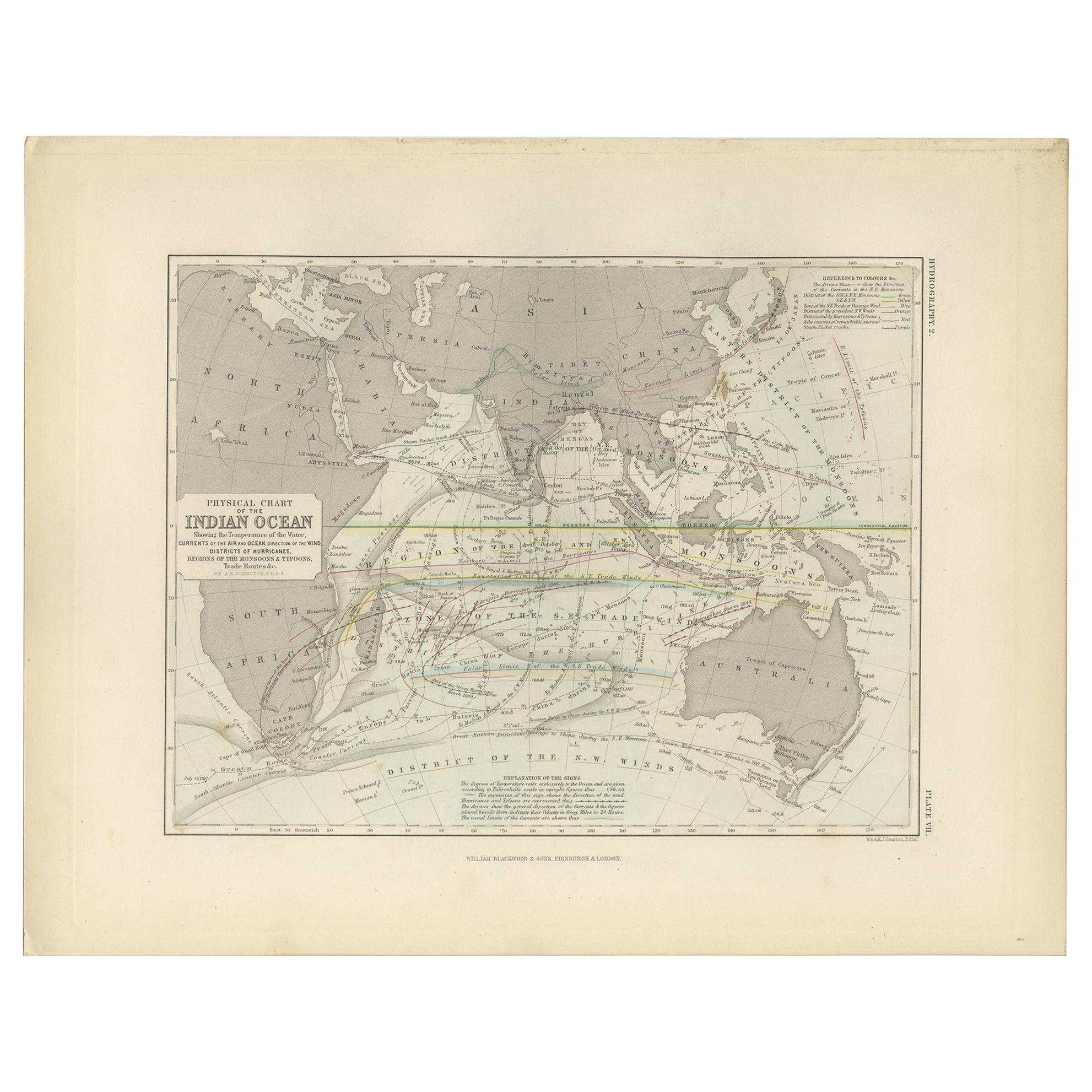
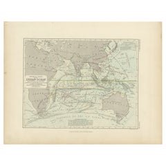
View AllAntique Physical Chart of the Indian Ocean by Johnston '1850'
Located in Langweer, NL
Antique map titled 'Physical Chart of the Indian Ocean showing the temperature of the water'. Original antique chart of the Indian Ocean. This map originates from 'The Physical Atlas...
Category
Antique Mid-19th Century Maps
Materials
Paper
$239 Sale Price
20% Off
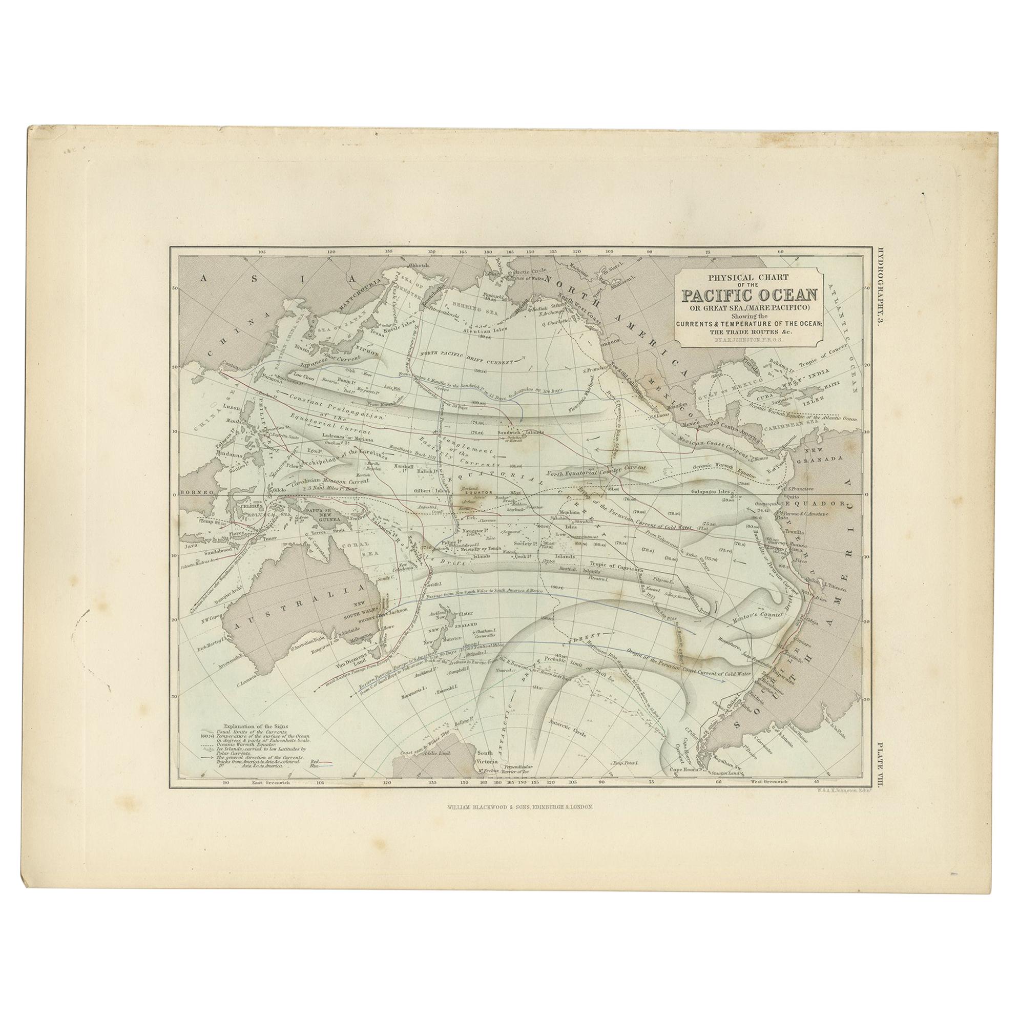
Antique Physical Chart of the Pacific Ocean by Johnston, '1850'
Located in Langweer, NL
Antique map titled 'Physical Chart of the Pacific Ocean showing the currents and temperature of the ocean'. Original antique chart of the Pacific Ocean. This map originates from 'The...
Category
Antique Mid-19th Century Maps
Materials
Paper
$191 Sale Price
20% Off
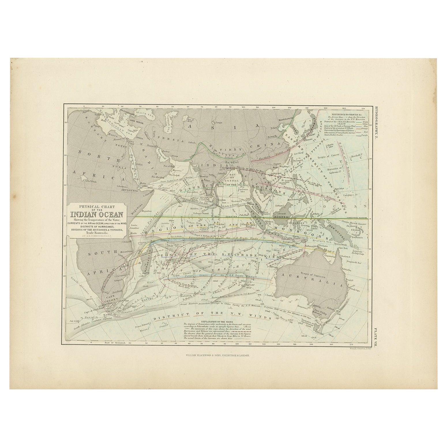
Antique Physical Chart of the Indian Ocean by Johnston, 1850
Located in Langweer, NL
Antique map titled 'Physical Chart of the Indian Ocean'. This map shows the temperature of the water, currents of the air and ocean, direction of the wind, districts of hurricanes, t...
Category
Antique 19th Century Maps
Materials
Paper
$124 Sale Price
20% Off
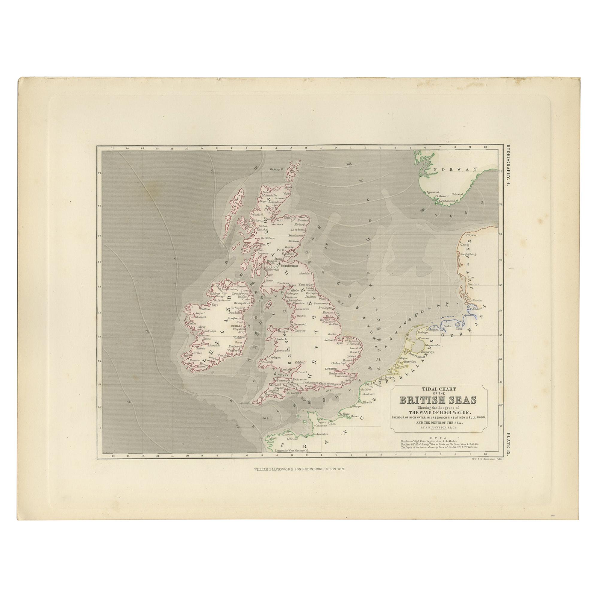
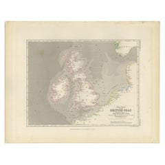
Antique Tidal Chart of the British Seas by Johnston, '1850'
Located in Langweer, NL
Antique map titled 'Tidal Chart of the British Seas showing the progress of the wave of high water'. Original antique tidal chart of the British Seas. This map originates from 'The P...
Category
Antique Mid-19th Century Maps
Materials
Paper
$191 Sale Price
20% Off
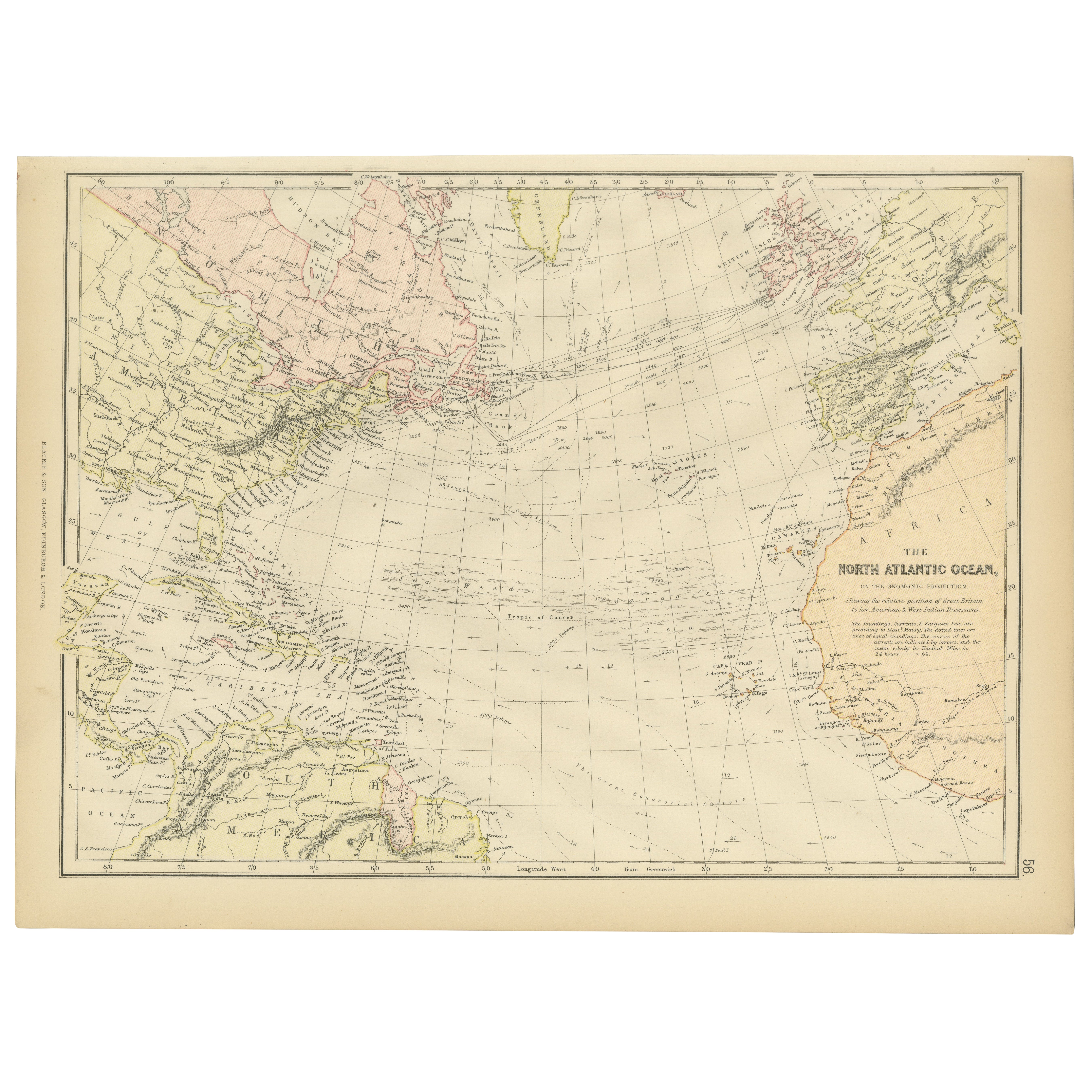
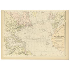
1882 Map of the North Atlantic Ocean Showing Cable Tracks and Trade Winds
Located in Langweer, NL
This 1882 map of the North Atlantic Ocean, published by Blackie and Son as part of the 'Comprehensive Atlas and Geography of the World,' provides an intricate depiction of one of the...
Category
Antique 1880s Maps
Materials
Paper
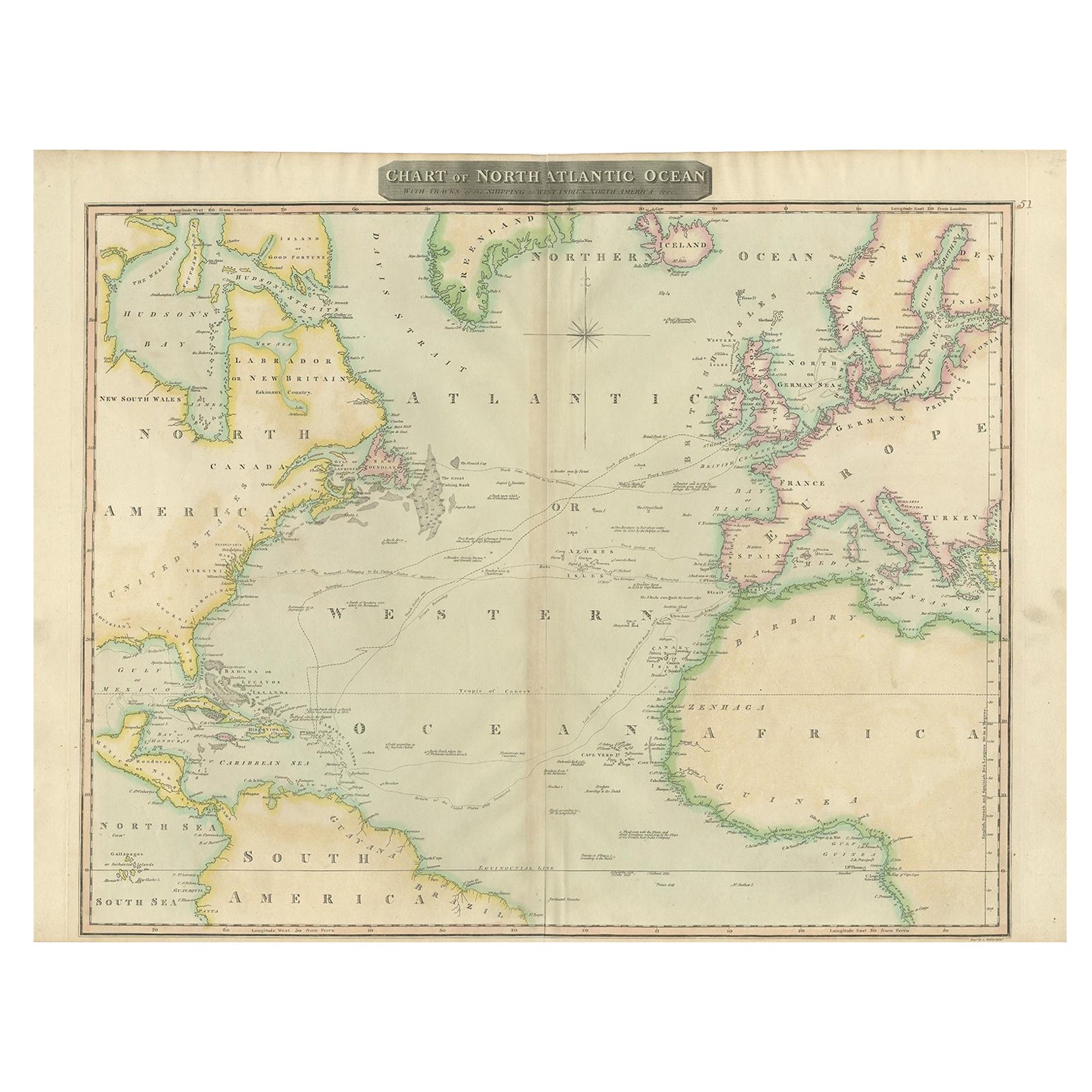
Interesting Map of the Atlantic Showing Nelson's and Trade Routes, 1817
By John Thomson
Located in Langweer, NL
Antique map titled 'Chart of the North Atlantic Ocean with Tracks of the Shipping to West Indies, North America, &cc'. Large map of the Atlantic, showing the tracks of the ships trad...
Category
Antique 19th Century Maps
Materials
Paper
$527 Sale Price
20% Off
Free Shipping
You May Also Like
Large Original Antique Map of The Pacific Ocean, Fullarton, C.1870
Located in St Annes, Lancashire
Great map of The Pacific Ocean
From the celebrated Royal Illustrated Atlas
Lithograph by Swanston. Original color.
Published by Fullarton,...
Category
Antique 1870s Scottish Maps
Materials
Paper

Original Imray & Son Chart of North Atlantic, 1876
Located in Norwell, MA
Nautical chart of the North Atlantic showing the Eastern United States coast, Caribbean Islands, South America (Venezuela and ), British Possessions (Canada - Gulf of Lawrence, Newfo...
Category
Antique 1870s Nautical Objects
Materials
Paper

Large U.S. Coast and Geodetic Survey Chart A of the Atlantic Coast, 1877
Located in Nantucket, MA
Large U.S. Coast and Geodetic Survey Chart A of the Atlantic Coast, 1877, re-issued in February 1881, a printed paper laid down on linen navigational chart of the U.S. Atlantic coast...
Category
Antique 1880s American Other Maps
Materials
Linen

Antique Maritime Chart of East Coast Virginia to Nova Scotia
Located in Norwell, MA
1920 nautical chart of the East Coast of the United States from Virginia to Maine, New Brunswick, and Nova Scotia. The chart shows Cape Cod, Long Island, the Connecticut coast, Jersey Shore, Maine, New Hampshire, etc. Very detailed, showing ports, lighthouses, shoals, depths, etc. The chart is by famous cartographer George W. Eldridge, compiled from surveys of the United States government, British Admiralty, George Eldridge, and others. First authorized by George Eldridge, published in 1916 by Wilfred O. White with a merchant's stamp of Charles Hutchinson...
Category
Vintage 1920s North American Maps
Materials
Paper

The Atlantic Ocean - Original Etching by A. Stieler - 1857
Located in Roma, IT
The Atlantic Ocean is an original colored print realized in 1857.
Hand-colored engraving made in Gotha (Germany) by Adolf Stieler.
Good conditions except for some light yellowing t...
Category
1950s Figurative Prints
Materials
Etching
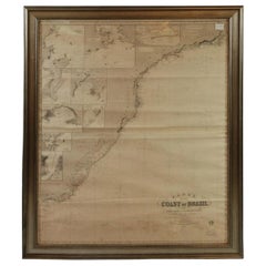
Imray Ocean Chart of the Coast of Brazil 1876
Located in Norwell, MA
Imray & Son 1876 Nautical chart of the Coast of Brazil between Cape Frio and the River Plate. Nicely framed. Overall Dimensions: 46" H x 56" W.
Category
Antique 1870s Nautical Objects
Materials
Paper
More Ways To Browse
Turkey Map
Map Of Austria
Antique Mediterranean Map
Antique Furniture Building Plans
Map Of Ireland
18th Century Compass
18th Century Maps America
Map Of Great Britain
Miniature Maps
Antique Map New York
Antique Wine Maps
Antique Map Of The South Of France
Antique Maps Of Greece
Large Framed Maps
Java Map
Antique Marine Maps
Antique Indian Maps
West Africa Map