Items Similar to Antique Plan of the Fortress of Greetsiel, Germany, by Blaeu, c.1650


Want more images or videos?
Request additional images or videos from the seller
1 of 6
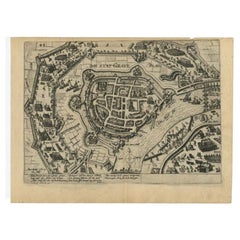
Antique Plan of the Fortress of Greetsiel, Germany, by Blaeu, c.1650
$316.58
$395.7320% Off
£235.51
£294.3820% Off
€264
€33020% Off
CA$433.51
CA$541.8920% Off
A$482
A$602.5120% Off
CHF 251.68
CHF 314.6020% Off
MX$5,867.17
MX$7,333.9720% Off
NOK 3,211.28
NOK 4,014.1020% Off
SEK 3,008.82
SEK 3,761.0220% Off
DKK 2,009.69
DKK 2,512.1120% Off
Shipping
Retrieving quote...The 1stDibs Promise:
Authenticity Guarantee,
Money-Back Guarantee,
24-Hour Cancellation
About the Item
Antique plan titled 't Fort van Griet-Zyl in Oost-Vrieslant'. Plan of the fortress of Greetsiel, Germany. This print originates from 'Novum ac magnum theatrum urbium Belgicae' by J. Blaeu.
Artists and Engravers: Joan Blaeu was a Dutch cartographer born in Alkmaar, the son of cartographer Willem Blaeu. Born circa 1596 and circa 1610 respectively, Joan and Cornelis Blaeu took over their father’s business upon his death in 1638. In the same year Joan Blaeu also assumed his father’s position as the official cartographer to the V.O.C. The Blaeu brothers worked hard to maintain the firm’s position of prominence, but only five years later in 1642, Cornelius Blaeu died, leaving the publishing firm solely in the hands of Joan Blaeu.
Condition: Good, general age-related toning. Left margin extended, Latin text on verso. Minor wear, please study image carefully.
Date: c.1650
Overall size: 31 x 43 cm.
Image size: 26 x 35 cm.
We sell original antique maps to collectors, historians, educators and interior decorators all over the world. Our collection includes a wide range of authentic antique maps from the 16th to the 20th centuries. Buying and collecting antique maps is a tradition that goes back hundreds of years. Antique maps have proved a richly rewarding investment over the past decade, thanks to a growing appreciation of their unique historical appeal. Today the decorative qualities of antique maps are widely recognized by interior designers who appreciate their beauty and design flexibility. Depending on the individual map, presentation, and context, a rare or antique map can be modern, traditional, abstract, figurative, serious or whimsical. We offer a wide range of authentic antique maps for any budget.
- Dimensions:Height: 16.93 in (43 cm)Width: 12.21 in (31 cm)Depth: 0 in (0.01 mm)
- Materials and Techniques:
- Period:
- Date of Manufacture:circa 1650
- Condition:Condition: Good, general age-related toning. Left margin extended, Latin text on verso. Minor wear, please study image carefully.
- Seller Location:Langweer, NL
- Reference Number:Seller: BG-12528-2'1stDibs: LU3054329264432
About the Seller
5.0
Recognized Seller
These prestigious sellers are industry leaders and represent the highest echelon for item quality and design.
Platinum Seller
Premium sellers with a 4.7+ rating and 24-hour response times
Established in 2009
1stDibs seller since 2017
2,510 sales on 1stDibs
Typical response time: <1 hour
- ShippingRetrieving quote...Shipping from: Langweer, Netherlands
- Return Policy
Authenticity Guarantee
In the unlikely event there’s an issue with an item’s authenticity, contact us within 1 year for a full refund. DetailsMoney-Back Guarantee
If your item is not as described, is damaged in transit, or does not arrive, contact us within 7 days for a full refund. Details24-Hour Cancellation
You have a 24-hour grace period in which to reconsider your purchase, with no questions asked.Vetted Professional Sellers
Our world-class sellers must adhere to strict standards for service and quality, maintaining the integrity of our listings.Price-Match Guarantee
If you find that a seller listed the same item for a lower price elsewhere, we’ll match it.Trusted Global Delivery
Our best-in-class carrier network provides specialized shipping options worldwide, including custom delivery.More From This Seller
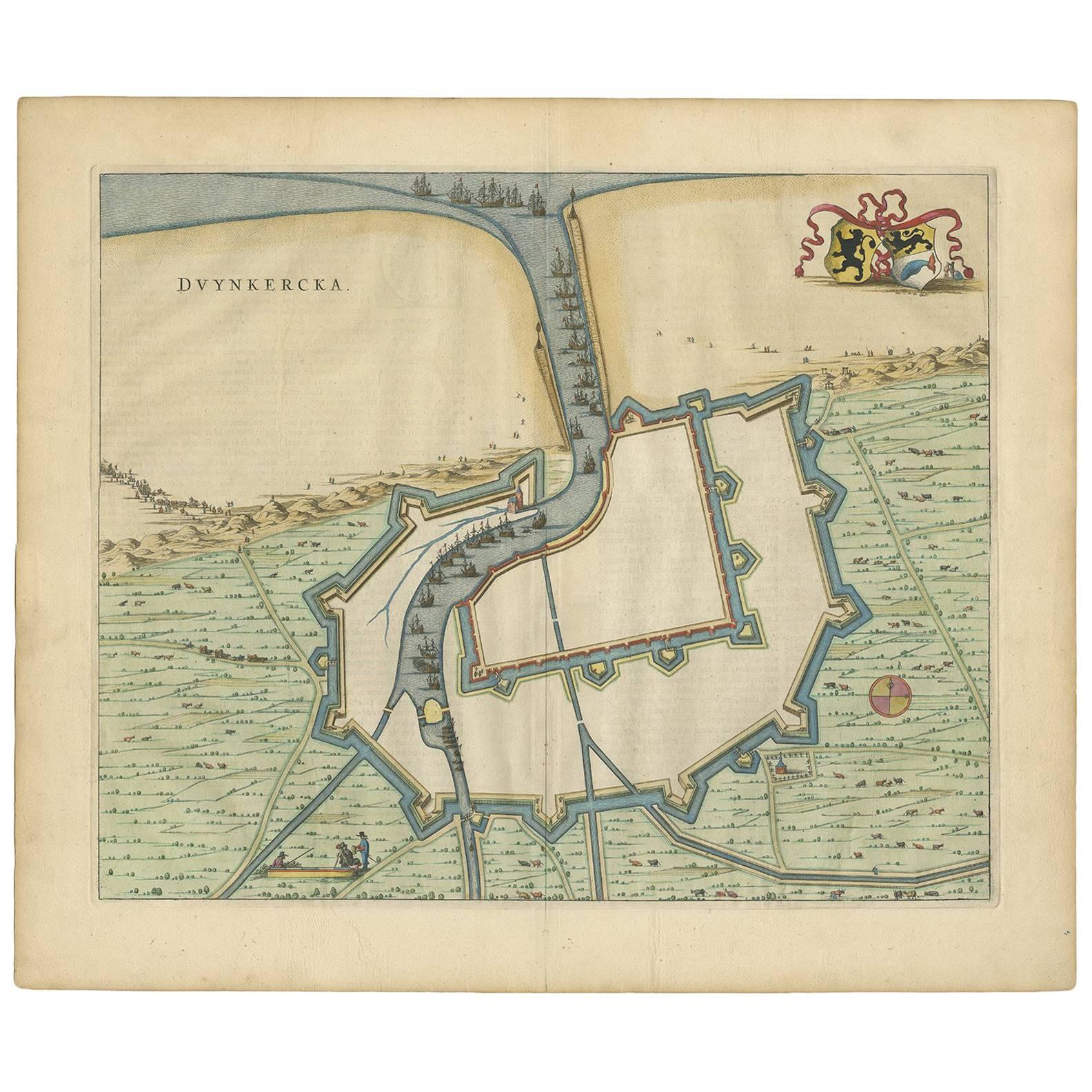
View AllAntique Map of Dunkirk 'France' by J. Blaeu, 1649
Located in Langweer, NL
Antique map titled 'Duynkercka'. Published by J. Blaeu, 1649. Dutch text on verso.
Category
Antique Mid-17th Century Maps
Materials
Paper

$503 Sale Price
20% Off
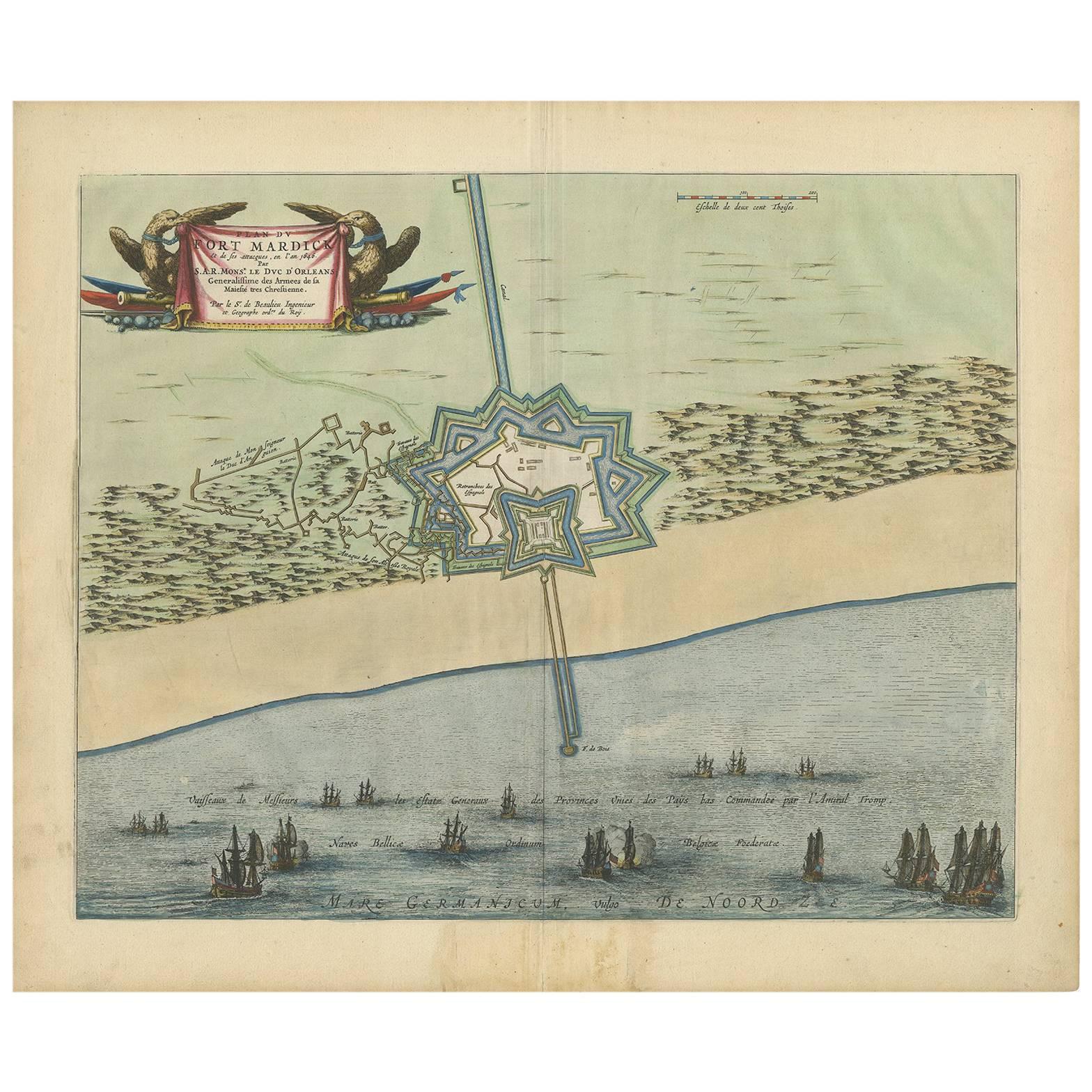
Antique Plan of Fort Mardyck Mardijk, France by S. Beaulieu, 1649
Located in Langweer, NL
Plan of Fort Mardyck (Fort Mardijk) and surroundings by Sébastian de Pontault Beaulieu. Mardyck is a former commune in the Nord department in northern France. It is an associated com...
Category
Antique Mid-17th Century Maps
Materials
Paper

$513 Sale Price
20% Off
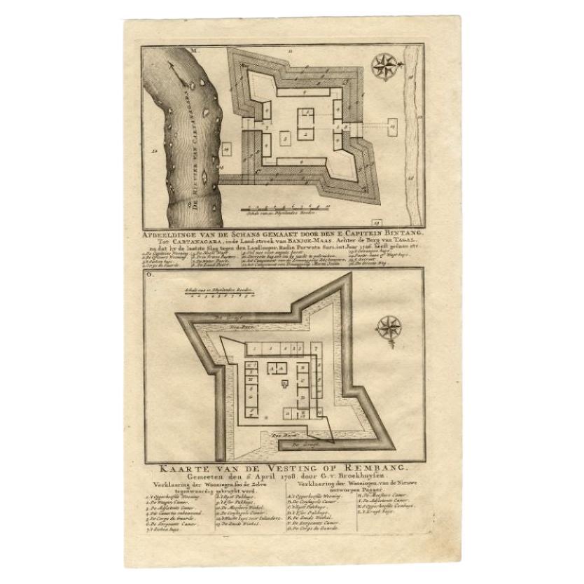
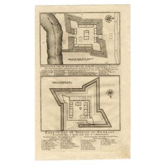
Antique Map of the Fortress of Captain E. Bintang by Valentijn, 1726
Located in Langweer, NL
Antique print titled 'Kaarte van de Schans gemaakt door den E. Capitein Bintang. Kaarte van de Vesting op Rembang.' A plan of the fort constructed by the Captain E. Bintang, in the B...
Category
Antique 18th Century Maps
Materials
Paper
$89 Sale Price
20% Off
Antique Plan of Grave, The Netherlands, Showing the Siege of Grave in 1602
Located in Langweer, NL
Antique map titled 'Die Stat Grave' Bird's eye view plan of Grave, The Netherlands, Holland. Showing the siege of Grave in the year 1602 by Prince Maurits of The Netherlands. Source ...
Category
Antique 16th Century Maps
Materials
Paper
$422 Sale Price
20% Off
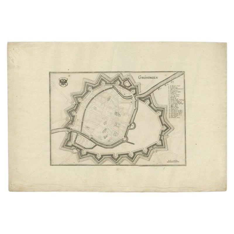
Antique Map of the City of Groningen by Merian, 1659
Located in Langweer, NL
Antique map titled 'Gröningen'. This print depicts the city of Groningen, the Netherlands. This print originates from 'Topographia Germaniae Inferioris (..)' by C. Merian.
Artist...
Category
Antique 17th Century Maps
Materials
Paper
$88 Sale Price
20% Off
Antique Map of The Siege of Gennep, the Netherlands, c.1650
Located in Langweer, NL
Antique map titled 'Belagerung des Besten Schloss und Passes Gennep'. Old map of the Siege of Gennep, the Netherlands. This map originates from 'Theatrum Europaeum' by M. Merian. Art...
Category
Antique 17th Century Maps
Materials
Paper

$230 Sale Price
20% Off
You May Also Like
18th Century Map Engraving - Newport, a Strong Sea-Port Town in Flanders
Located in Corsham, GB
A map of Nieuwpoort, anglicised to 'Newport', in northern Belgium. There is a panorama in the upper quarter depicting major landmarks. Below is a plan of the town, including its strong defences and ships at the port in the lower register. Inscribed with the title in plate to the lower edge, 'Newport a Strong Sea-Port Town...
Category
18th Century More Prints
Materials
Engraving

$269 Sale Price
20% Off
Map of the Netherlands - Etching by G. Braun and F. Hogenberg -Late 16th Century
By Franz Hogenberg
Located in Roma, IT
Map of the Netherlands is an original etching realized by George Braun and Franz Hogenberg, as part of the "Civitates Orbis Terrarum".
The “Civitates Orbis Terrarum” (Atlas of Citi...
Category
16th Century Figurative Prints
Materials
Etching

1620 Map of Artois Entitled "Artesia Comitatvs Artois, " by Bleau, Ric.a012
Located in Norton, MA
1640 map of Artois entitled
"Artesia Comitatvs Artois,"
by Bleau
Colored
A-012.
Detailed map of the northern province of Artois, France on the border with Belgium. Feature...
Category
Antique 17th Century Dutch Maps
Materials
Paper

1635 Willem Blaeu Map of Northern France"Comitatvs Bellovacvm" Ric.a08
Located in Norton, MA
1635 Willem Blaeu map of northern France, entitled.
"Comitatvs Bellovacvm Vernacule Beavvais,"
Colored
Ric.a008
“COMITATVS BELLOVACVM…” Amsterdam: W...
Category
Antique 17th Century Unknown Maps
Materials
Paper

1643 Willem&Joan Blaeu Map NW Flanders "Flandriae Teutonicae Pars Prientalior
Located in Norton, MA
1643 Willem and Joan Blaeu map of northwest Flanders, entitled
"Flandriae Teutonicae Pars Prientalior,"
Ric0012
" Authentic" - Map of the northwest Fl...
Category
Antique 17th Century Dutch Maps
Materials
Paper

17th Century Toulouse, Savve, Sommieres Topographical Map by Iohan Peeters
Located in New York, NY
Fine topographical 17th century map of Toulouse, Savve and Sommieres by Iohan Peeters
Beautiful engraving of the capital of France's Occitanie Region, Toulouse, called La Ville Rose- the Pink City, for the terracotta bricks used in its many buildings, giving the city a distinct apricot-rose hue. An important cultural and educational center, the city's residents included Nobel Prize winners and world renown artists- Henri de Toulouse-Lautrec, Henri Martin, Jean-Auguste-Dominique Ingres, Antonin Mercie, Alexandre Falguiere and more recently Cyril Kongo...
Category
Antique 17th Century Dutch Maps
Materials
Paper

More Ways To Browse
Antique Maps Massachusetts
Guyana Antique Map
Peninsular War
Santa Cruz Island
Ukraine Antique Map
Antique Life Buoy
Antique Map Nova Scotia
Antique Map Of Argentina
Antique Maps Of Kansas
Cambodia Antique Map
Magellan Map
Map Ukraine
Mariners Chart
Papua New Guinea Antique Map
Bermuda Map
Scan Globe
Tunisia Antique Map
Antique Map New Orleans