Items Similar to Atlantic Eden: The Azores and Madeira Archipelagos in 1903


Want more images or videos?
Request additional images or videos from the seller
1 of 9
Atlantic Eden: The Azores and Madeira Archipelagos in 1903
$325.90
$407.3720% Off
£242.56
£303.2020% Off
€272
€34020% Off
CA$446.39
CA$557.9920% Off
A$496.49
A$620.6120% Off
CHF 259.25
CHF 324.0620% Off
MX$6,041.74
MX$7,552.1720% Off
NOK 3,311.03
NOK 4,138.7920% Off
SEK 3,105.16
SEK 3,881.4520% Off
DKK 2,070.64
DKK 2,588.3020% Off
Shipping
Retrieving quote...The 1stDibs Promise:
Authenticity Guarantee,
Money-Back Guarantee,
24-Hour Cancellation
About the Item
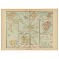
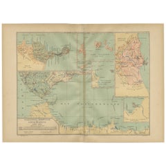
This original antique print is a historical map titled "PORTUGAL INSULAR," which translates to "Insular Portugal." It shows the Portuguese archipelagos of the Azores and Madeira, with detailed insets for each major island such as São Miguel, Terceira, Faial, Pico, São Jorge, Graciosa, Flores, Corvo, Madeira, and Porto Santo.
These archipelagos are special for various reasons:
**The Azores (Arquipélago dos Açores):**
1. **Geothermal and Volcanic Activity**: The Azores are situated over the meeting point of three tectonic plates, leading to notable geothermal and volcanic activity, with hot springs and geysers, especially on São Miguel.
2. **Biodiversity and Nature**: The islands are known for their lush, green landscapes, dramatic cliffs, and diverse marine life, which makes it a popular spot for whale watching.
3. **Cultural Heritage**: The Azores have a rich history, reflected in the architecture, festivals, and traditions that are unique to the islands.
4. **Agriculture**: The islands are also known for dairy farming and the production of the famous São Jorge cheese.
**Madeira Archipelago (Arquipélago da Madeira):**
1. **Subtropical Climate**: Madeira enjoys a year-round mild climate, which has made it a popular destination for tourists seeking a temperate getaway.
2. **Levadas and Hiking**: The network of levadas (irrigation channels) provides unique hiking trails through stunning landscapes and ancient laurel forests.
3. **Flora and Fauna**: Madeira is famous for its rich botanical gardens, exotic flowers, and birdlife.
4. **Madeira Wine**: The island is renowned for its namesake wine, a fortified wine that has been produced there for centuries.
- Dimensions:Height: 14.77 in (37.5 cm)Width: 20.08 in (51 cm)Depth: 0 in (0.02 mm)
- Materials and Techniques:
- Period:1900-1909
- Date of Manufacture:1903
- Condition:Good condition. Central vertical folding lines as issued. Aged paper with typically warm, yellowish-brown hue, especially around the edges and folding lines, adding to its patina. Check the images carefully.
- Seller Location:Langweer, NL
- Reference Number:Seller: BG-13642-591stDibs: LU3054338034772
About the Seller
5.0
Recognized Seller
These prestigious sellers are industry leaders and represent the highest echelon for item quality and design.
Platinum Seller
Premium sellers with a 4.7+ rating and 24-hour response times
Established in 2009
1stDibs seller since 2017
2,502 sales on 1stDibs
Typical response time: <1 hour
- ShippingRetrieving quote...Shipping from: Langweer, Netherlands
- Return Policy
Authenticity Guarantee
In the unlikely event there’s an issue with an item’s authenticity, contact us within 1 year for a full refund. DetailsMoney-Back Guarantee
If your item is not as described, is damaged in transit, or does not arrive, contact us within 7 days for a full refund. Details24-Hour Cancellation
You have a 24-hour grace period in which to reconsider your purchase, with no questions asked.Vetted Professional Sellers
Our world-class sellers must adhere to strict standards for service and quality, maintaining the integrity of our listings.Price-Match Guarantee
If you find that a seller listed the same item for a lower price elsewhere, we’ll match it.Trusted Global Delivery
Our best-in-class carrier network provides specialized shipping options worldwide, including custom delivery.More From This Seller
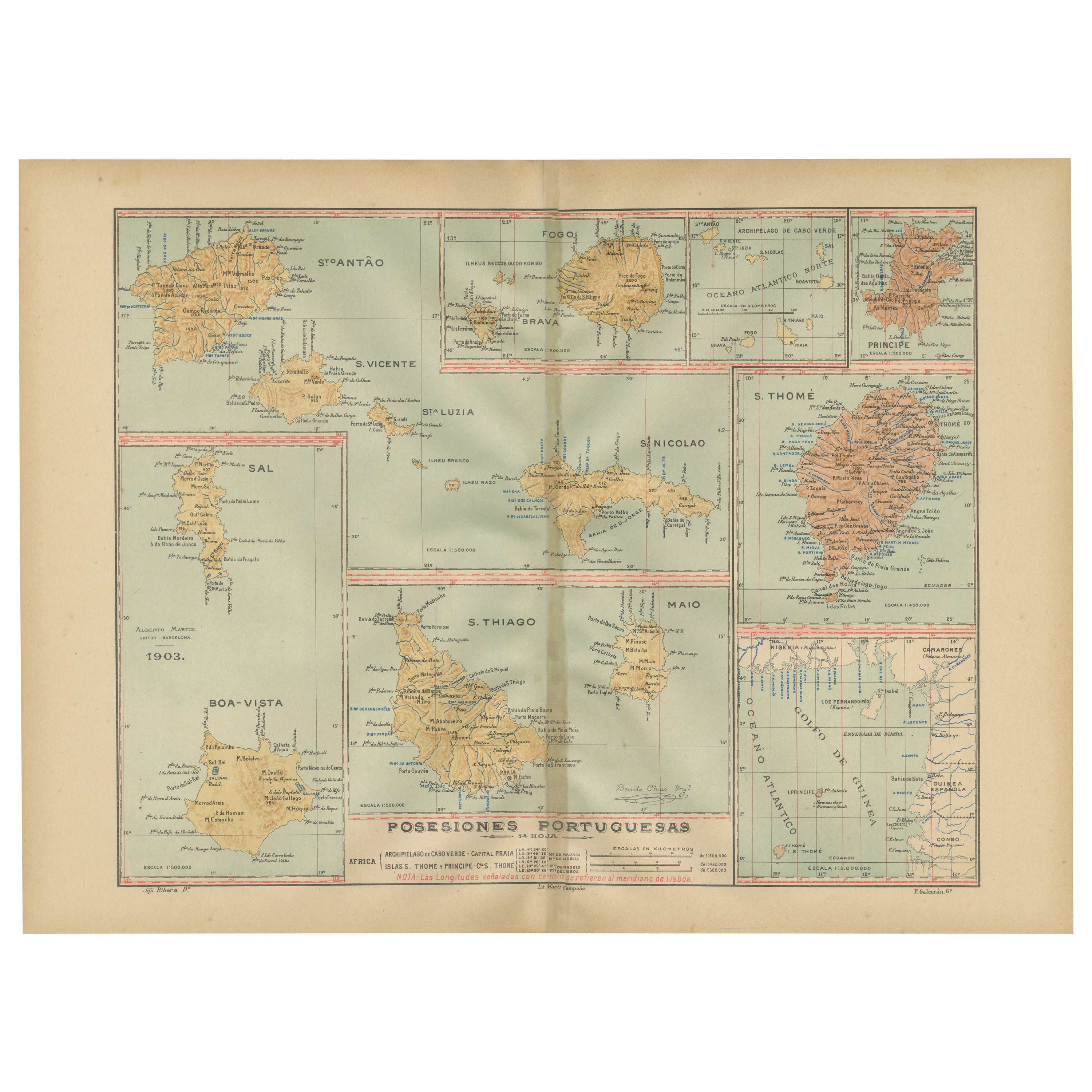
View AllIslands of Diversity: Portugal's Atlantic Archipelagos in 1903
Located in Langweer, NL
The image is an original historical map from 1903 depicting Portuguese possessions in the Atlantic Ocean, specifically the islands of Cape Verde and the islands of São Tomé and Prínc...
Category
Antique Early 1900s Maps
Materials
Paper
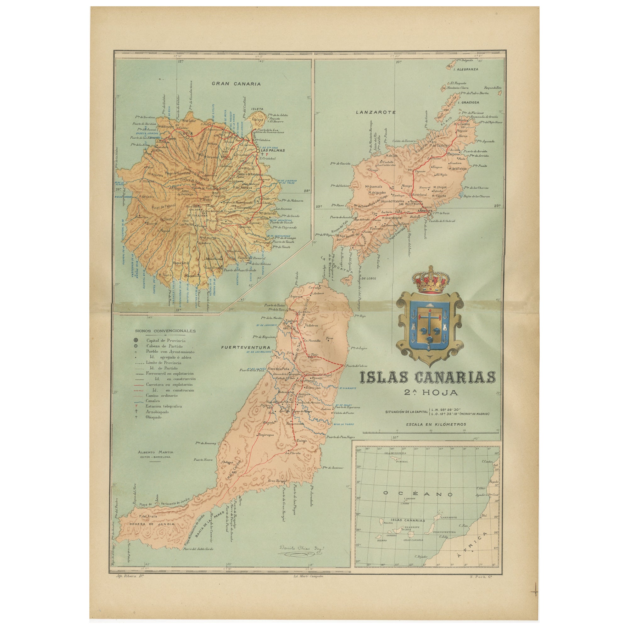
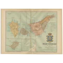
Islands of Fire and Whispers: The Canary Islands in 1902
Located in Langweer, NL
This is a authentic historical map of the Canary Islands, specifically the "1A HOJA" or first sheet, from the year 1902. The title on the map is "ISLAS CANARIAS 1902." This map featu...
Category
Antique Early 1900s Maps
Materials
Paper
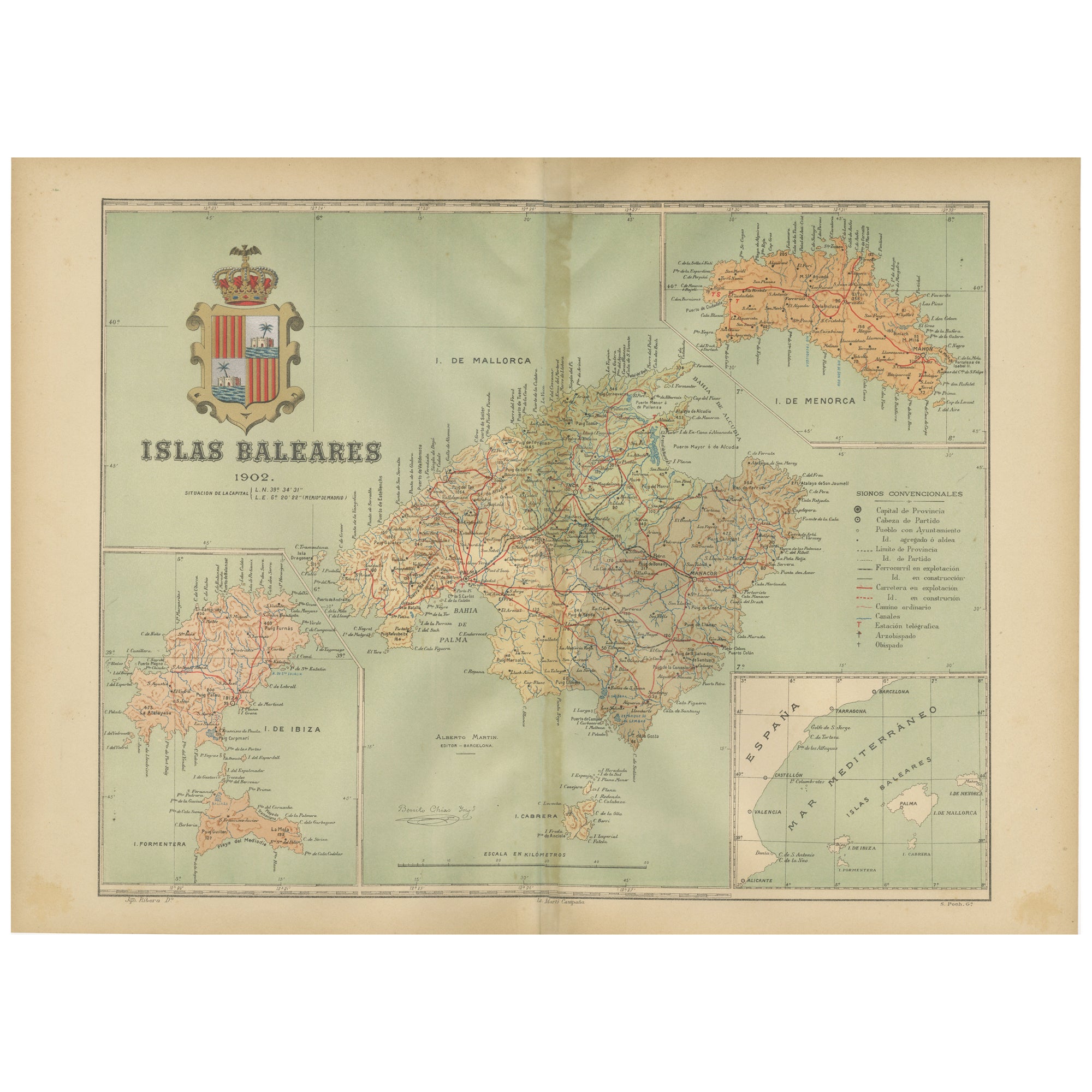
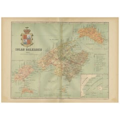
Isles of Enchantment: The Balearic Archipelago in 1902
Located in Langweer, NL
The Balearic Islands, Spain, from the year 1902. The title on the map is "ISLAS BALEARES 1902." This map illustrates the Balearic archipelago in the Mediterranean Sea, highlighting t...
Category
Antique Early 1900s Maps
Materials
Paper
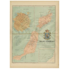
Volcanic Eden: The Canary Islands’ Tapestry of Land and Sea in 1902
Located in Langweer, NL
The map is the second sheet (2ª HOJA) of a historical map series of the Canary Islands from 1902. It depicts three of the major islands: Gran Canaria, Fuerteventura, and Lanzarote, a...
Category
Antique Early 1900s Maps
Materials
Paper
$354 Sale Price
20% Off
Free Shipping
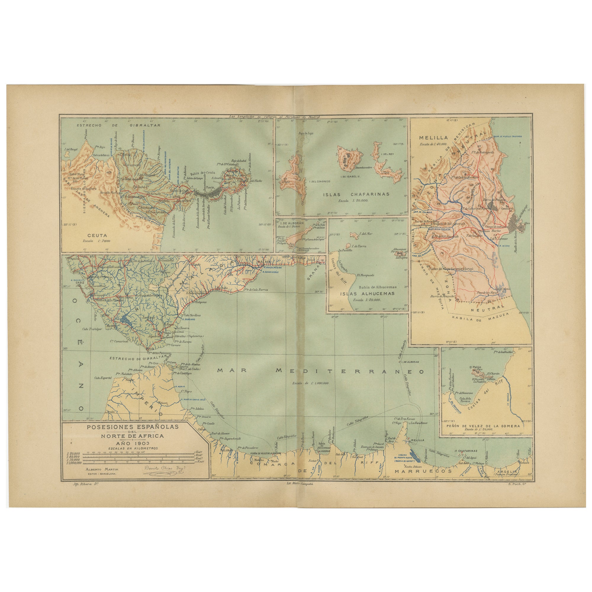
Crossroads of Continents: Spain's North African Enclaves in 1903
Located in Langweer, NL
The image for sale is a historical map of Spanish possessions in North Africa, dated 1903. The map includes the enclaves of Ceuta and Melilla, the Chafarinas Islands, the Alhucemas I...
Category
Antique Early 1900s Maps
Materials
Paper
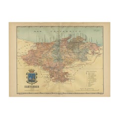
Maritime and Terrestrial Survey of Spanish Santander in 1901, An Original Map
Located in Langweer, NL
This antique map is a historical map of the province of Santander (currently known as Cantabria) from the year 1901. Santander is located along the northern coast of Spain, bordering...
Category
Antique Early 1900s Maps
Materials
Paper
$277 Sale Price
20% Off
Free Shipping
You May Also Like
Large Original Antique Map of The Canary Islands. 1894
Located in St Annes, Lancashire
Superb Antique map of The Canary Islands
Published Edward Stanford, Charing Cross, London 1894
Original colour
Good condition
Unframed.
Free shipping
Category
Antique 1890s English Maps
Materials
Paper

1865 Chart of the Islands of Madeira
Located in Norwell, MA
Rare James Imray chart from 1865 titled "Chart of the Islands of Madeira, Porto Santo and Dezerea" drawn from the survey made by Captain Ate Vidal Royal Navy, London. Published by Ja...
Category
Antique 1860s European Maps
Materials
Paper

Large Original Antique Map of Madeira. 1894
Located in St Annes, Lancashire
Superb Antique map of Madeira
Published Edward Stanford, Charing Cross, London 1894
Original colour
Good condition
Unframed.
Free shipping
Category
Antique 1890s English Maps
Materials
Paper

1898 Chart of Boston Bay
Located in Norwell, MA
Original 1898 chart showing Massachusetts Bay with the coast from Cape Ann to Cape Cod. This is a U.S. Navy Geodetic survey chart. All towns are noted along the coast. Framed with gl...
Category
Antique 1890s Nautical Objects
Materials
Paper

$1,495
Large Original Antique Map of The Leeward Islands. 1894
Located in St Annes, Lancashire
Superb Antique map of The Leeward Islands
Published Edward Stanford, Charing Cross, London 1894
Original colour
Good condition
Unframed.
Free shipping
Category
Antique 1890s English Maps
Materials
Paper

Original Antique Map of US Possessions In The Pacific Ocean, C.1900
Located in St Annes, Lancashire
Fabulous map of US possessions in the Pacific Ocean
Original color.
Engraved and printed by the George F. Cram Company, Indianapolis.
Published, C.1900.
Unframed.
Free shipping.
Category
Antique 1890s American Maps
Materials
Paper

More Ways To Browse
Marine Watch
Flora Fauna Plate
Madeira Wine
Antique Whale Print
Early American Chairs
Hans Muller
Vintage Wood Table With Glass Top
19th Century Square Table
Antonio Bonet
Galle Chairs
Large Chinese Rug
1940s Vintage French Art Deco
20th Century Spanish Table
Antonio Bellini
Retro Fiberglass Furniture
Shipping Crate
Antique Oushak Carpets
Blue Coffee Tables