Items Similar to Crossroads of Continents: Spain's North African Enclaves in 1903


Want more images or videos?
Request additional images or videos from the seller
1 of 9
Crossroads of Continents: Spain's North African Enclaves in 1903
About the Item
The image for sale is a historical map of Spanish possessions in North Africa, dated 1903. The map includes the enclaves of Ceuta and Melilla, the Chafarinas Islands, the Alhucemas Islands, and the Peñón de Vélez de la Gomera. These territories are located along the northern coast of Morocco and are significant due to their strategic positions at the crossroads of the Mediterranean and the Atlantic.
Ceuta and Melilla are two autonomous Spanish cities on the northern coast of Africa, bordered by Morocco. They have a complex history, shaped by their strategic military and trade positions and the cultural influences of Christians, Muslims, and Jews.
The Chafarinas Islands are an archipelago of three small islets, with Spain maintaining a garrison on one of them. Similarly, the Alhucemas Islands and the Peñón de Vélez de la Gomera are small territories under Spanish control.
These areas are known for:
1. **Military Significance**: Due to their strategic location, they have been historically significant for military control of the Mediterranean.
2. **Cultural Diversity**: The cities of Ceuta and Melilla, in particular, are known for their multicultural heritage, with Christian, Muslim, and Jewish communities coexisting.
3. **Biodiversity**: The islands, especially the Chafarinas Islands, are important for their biodiversity and are protected areas with a rich variety of birdlife and marine species.
4. **Migration Crossroads**: These enclaves are also contemporary hotspots for migration issues, as they are gateways between Africa and Europe.
- Dimensions:Height: 14.77 in (37.5 cm)Width: 20.08 in (51 cm)Depth: 0 in (0.02 mm)
- Materials and Techniques:
- Period:1900-1909
- Date of Manufacture:1903
- Condition:Good condition. Central vertical folding lines as issued. Aged paper with typically warm, yellowish-brown hue, especially around the edges and folding lines, adding to its patina. Check the images carefully.
- Seller Location:Langweer, NL
- Reference Number:
About the Seller
5.0
Platinum Seller
These expertly vetted sellers are 1stDibs' most experienced sellers and are rated highest by our customers.
Established in 2009
1stDibs seller since 2017
1,932 sales on 1stDibs
Typical response time: <1 hour
- ShippingRetrieving quote...Ships From: Langweer, Netherlands
- Return PolicyA return for this item may be initiated within 14 days of delivery.
More From This SellerView All
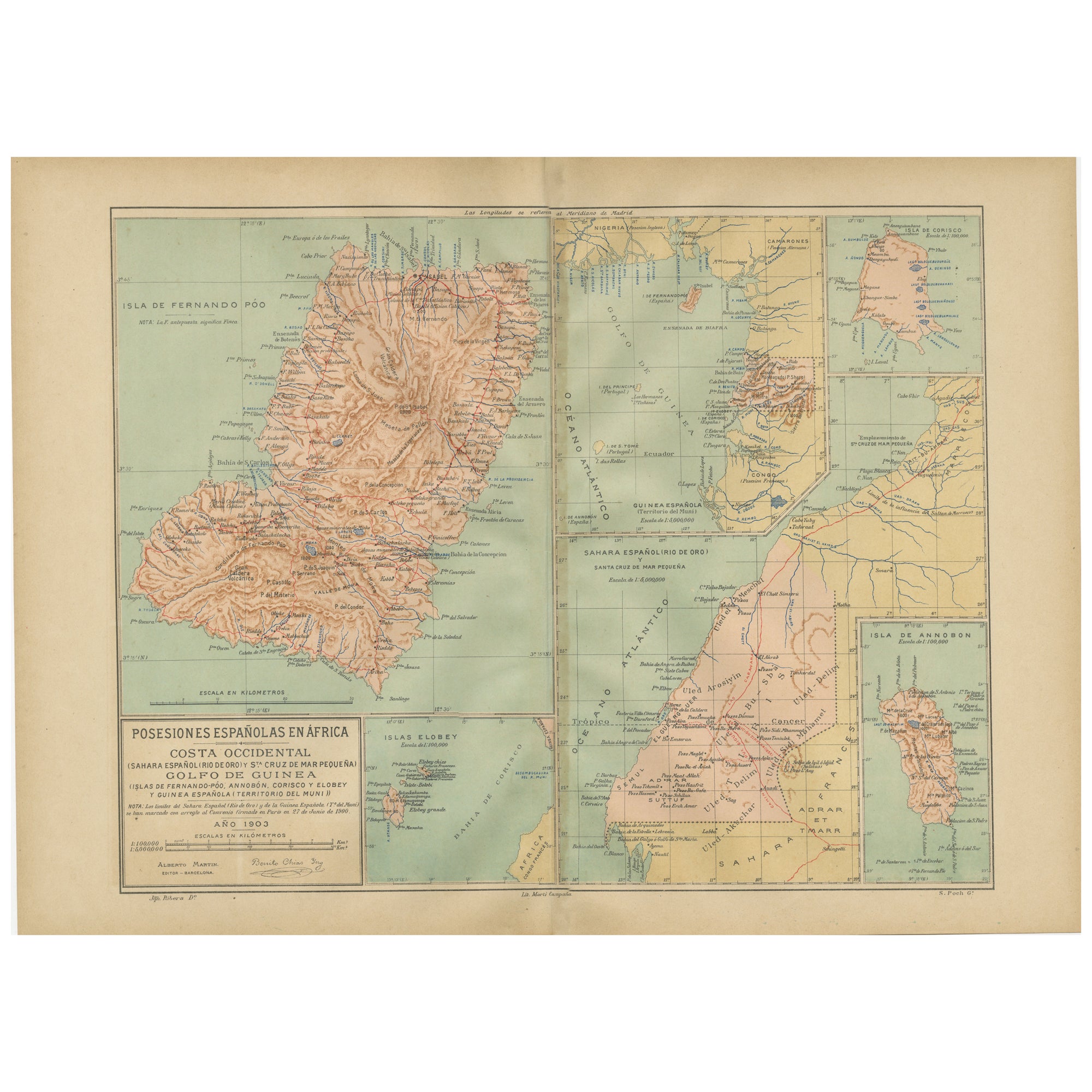
- Echoes of Empire: Spanish Territories in West Africa, 1903Located in Langweer, NLThis is a historical map showing Spanish possessions in West Africa from the year 1903. The map includes the islands of Fernando Póo (now known as Bioko), part of the modern-day country of Equatorial Guinea, Annobón Island, and the Elobey Islands, along with the Spanish-controlled areas on the continental region near Rio Muni. These territories were part of Spain's colonial empire and are situated in the Gulf of Guinea, off the coast of Central Africa. Fernando Póo (Bioko) is particularly notable for its volcanic origins and as a center of cocoa production during the colonial period. Annobón, lying further southwest of Bioko, is a small volcanic island. The Elobey Islands are very small and located near the coast of Gabon. Here's a brief overview of their significance: 1. **Bioko Island (Fernando Póo)**: The island has a rich biodiversity and is known for its unique flora and fauna, including several endemic species. Malabo, the capital city of Equatorial Guinea, is located here. 2. **Annobón Island**: This remote island has a small population and is known for its isolation and distinctive Creole culture, which has developed independently from the mainland. 3. **Elobey Islands**: These consist of Elobey Grande and Elobey Chico and are situated near the mouths of the Muni and Campo rivers. They were historically important as transit points in river trade...Category
Antique Early 1900s Maps
MaterialsPaper
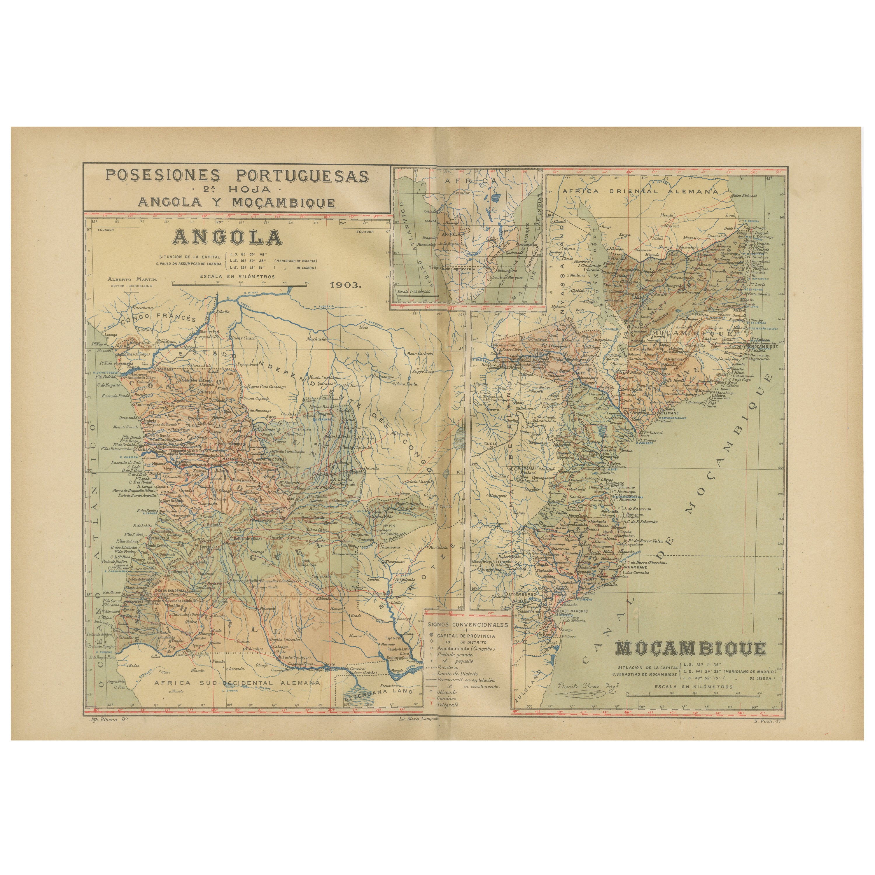
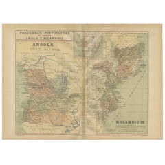
- Colonial Crossroads: Angola and Mozambique in 1903Located in Langweer, NLThe image for sale is an original historical map from 1903 that shows the Portuguese colonies of Angola on the left and Mozambique on the right. These two territories on the African ...Category
Antique Early 1900s Maps
MaterialsPaper
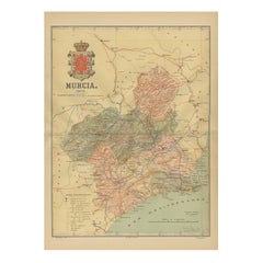
- 1902 Murcia: A Cartographic Snapshot of Spain's Southeastern ProvinceLocated in Langweer, NLThe map represents the province of Murcia, Spain, as it was in 1902. Here's an overview of its characteristics: - **Geography**: It displays the varied terrain of Murcia, from the c...Category
Antique Early 1900s Maps
MaterialsPaper
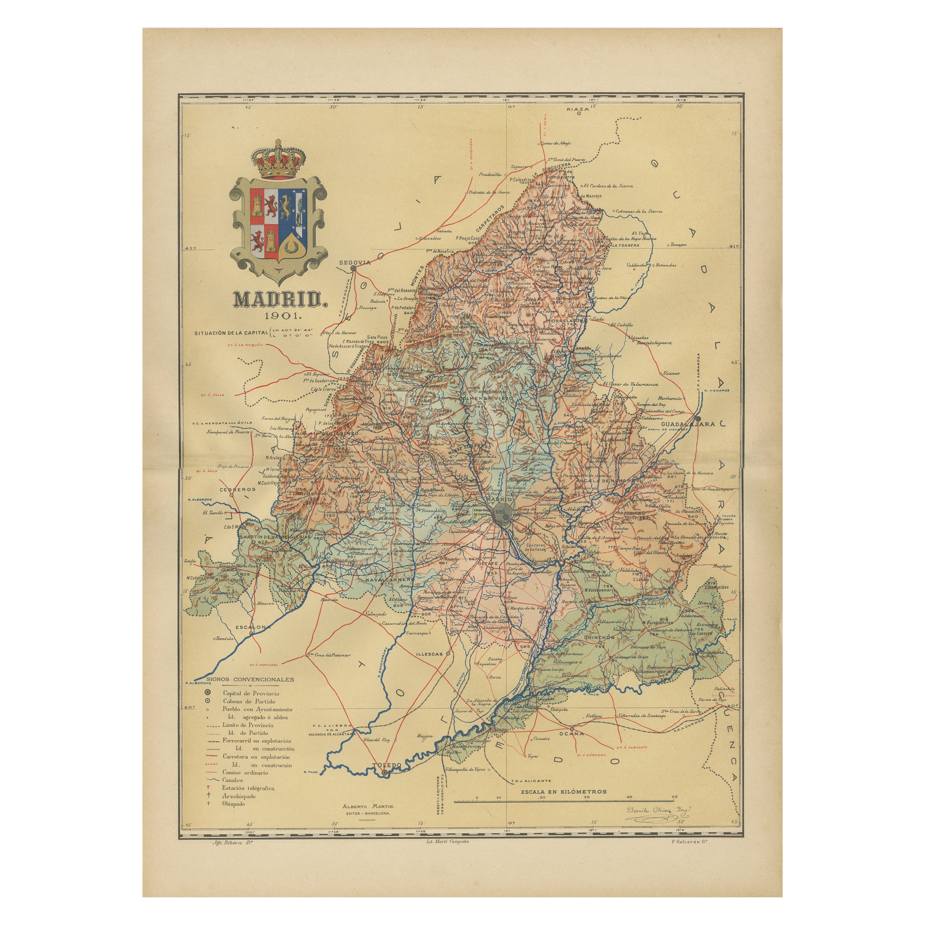
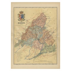
- Madrid 1901: A Historical Map of Spain's Capital ProvinceLocated in Langweer, NLThe map is of the province of Madrid, the capital region of Spain, as it appeared in 1901. Here are the key features it displays: The map shows the central part of Spain, with the Guadarrama mountain range prominently visible, marking the natural border to the north of Madrid. Blue lines likely indicate rivers, including the Manzanares River, which flows through Madrid, and the Jarama River, a tributary to the Tagus. Red lines depict the roads and railways, outlining the infrastructure that connects Madrid's various towns and cities within the province and beyond. Symbols and labels mark the locations of cities, towns, and villages, with Madrid itself likely being the focal point. Dotted lines may represent the administrative divisions within the province. The map includes a legend (Signos Convencionales) that explains the symbols used for provincial capitals, roads, railways, and other geographic features. The coat of arms of Madrid, featuring a bear and a strawberry tree (madroño), is prominently featured, symbolizing the city's and the province's historical coat of arms. About the province of Madrid: Madrid is not only the capital of Spain but also the heart of the Iberian Peninsula, both geographically and politically. The city is renowned for its rich repositories of European art, including the Prado Museum's works by Goya, Velázquez, and other Spanish masters. The province of Madrid is characterized by a blend of historical and modern elements, with a rich cultural life that includes theater, opera, and flamenco, as well as gastronomy that features a mix of traditional Spanish dishes and international cuisine...Category
Antique Early 1900s Maps
MaterialsPaper
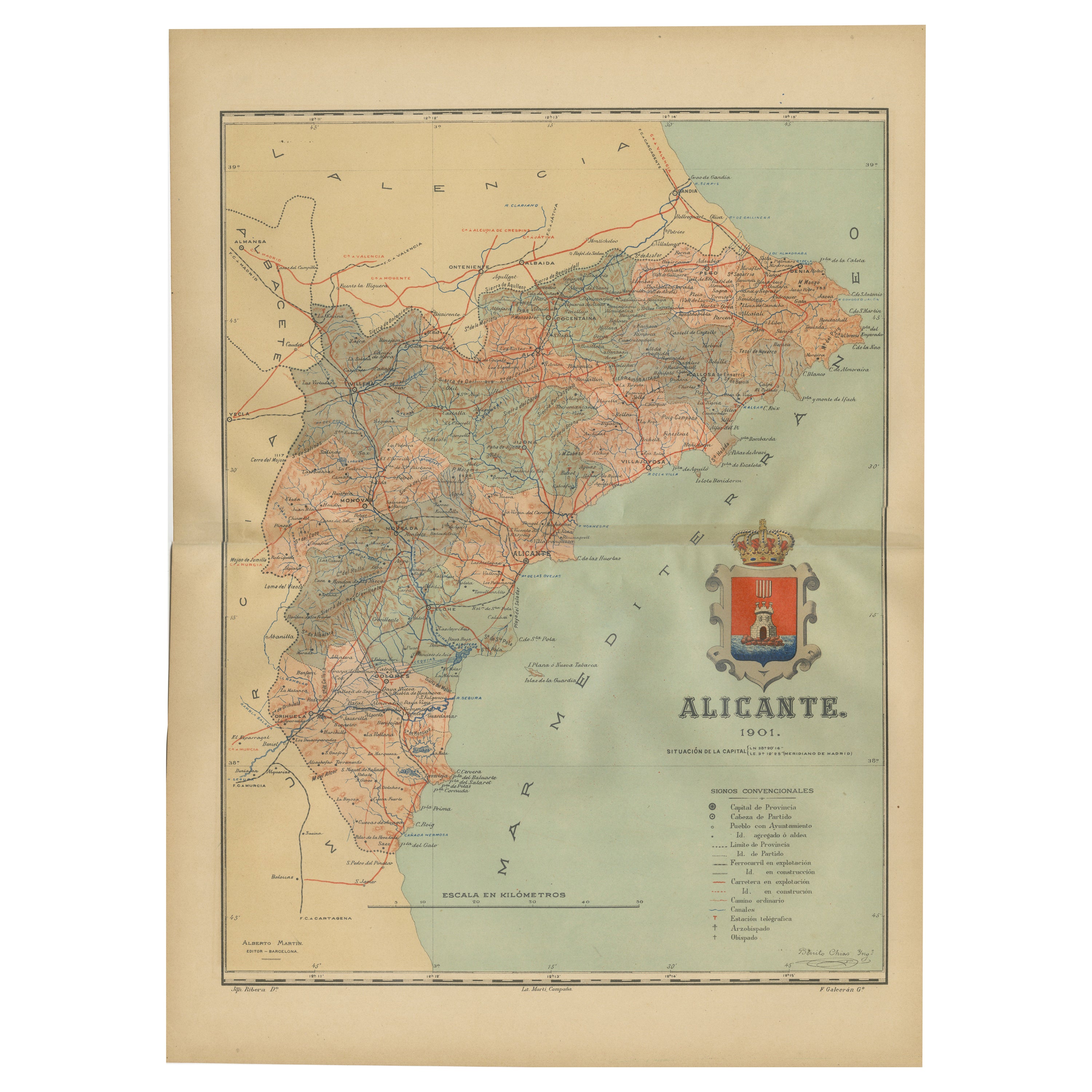
- Alicante in a 1901 Antique Map: Maritime Gateway of Spain's Costa BlancaLocated in Langweer, NLAn original antique map of the province of Alicante, dated 1901. It is part of the atlas series by D. Benito Chias y Carbo, featuring cartographic elements. Here are some characteri...Category
Antique Early 1900s Maps
MaterialsPaper
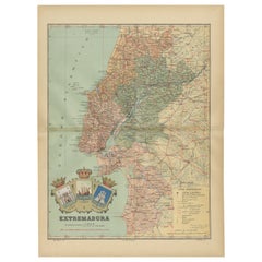
- An Antique Map of Extremadura: Crossroads of History and Nature, 1903Located in Langweer, NLThe image is a historical map of Extremadura, an autonomous community of Spain, from an unspecified year. The map features the region's topography, including mountain ranges, river s...Category
Antique Early 1900s Maps
MaterialsPaper


You May Also Like
- Africa: the Fashion ContinentBy Rizzoli International PublicationsLocated in New York, NYGain new perspective on the vibrant and innovative world of contemporary African fashion design, bursting with fresh creativity and free from reductive stereotypes. From the runway in Lagos and music festivals in Casablanca or Nairobi, to the “image makers” of Marrakech and the influencers of Dakar or Accra, a new generation of African fashion designers, photographers, bloggers, and hair and makeup artists are redefining the aesthetic contours of the continent. Audacious, humorous, disruptive, and innovative are the bywords of these young creatives who, while drawing upon and revalorizing their heritage, offer an ultra-contemporary perspective on fashion today. A creative revolution is spreading in an extension of continental revindication through cultural reappropriation and the invention of a visual language. Appliqué figures straight from Ghanaian Asafo flags seem to chant modern slogans as they march across silk dresses, traditional textile prints give power back to women, and Xhosa beaded embroidery serves as an inspiration for modern knitwear. Body-artists transform themselves into platforms for activism, and photographers—using clothing...Category
21st Century and Contemporary Books
MaterialsPaper
- Africa Aeterna the Pictorial Chronicle of a Continent Hardcover BookLocated in North Hollywood, CAAfrica Aeterna The Pictorial Chronicle of a Continent New York: International Book Society Time Life Books, 1965. Henry, Paul Marc; Carmichael, Joel (translator) Published by Sed...Category
Mid-20th Century African Tribal Books
MaterialsPaper
- The North African CookbookLocated in New York City, NY‘This cookbook is a must for a deep dive into North African classic and regional dishes.’ – Warda Bouguettaya, James Beard award-winning pastry chef and owner of Warda Patisserie, De...Category
21st Century and Contemporary Chinese Books
MaterialsPaper
- Ortega-Morejon, Cuentos De Color De Lila, Queen Isabella II of Spain's Copy 1887Located in Hillsborough, NJAuthor: ORTEGA-MOREJON, Jose Maria De. Title: Cuentos De Color De Lila Y Fragmentos Sin Color. Publisher: Madrid: Miguel Ginesta, Impresor De La Real Casa, 1887. Description: First Edition, presentation copy, from the library of Queen Isabella II of Spain. 1 vol., 8-3/8" x 5-15/16", inscribed on the half-title to Queen Isabella by Ortega-Morejon "Isabel II, gloriosa Soberana de los espanoles", bound in full tan morocco, ribbed gilt decorated spine, covers ruled in gilt, gilt crown and initials of the Queen to the front cover, gilt crest to the rear cover, gilt dentelles, white silk morie doublures and endpapers, all edges gilt. Condition: Internally clean and bright, hinges fine, head and foot of spine fine, overall Very good. Additional information: Isabella II (10 October 1830 – 9 April 1904), was Queen of Spain from 29 September 1833 until 30 September 1868. Shortly before her birth, the King Ferdinand VII...Category
Antique 1880s Spanish Books
MaterialsLeather
- Vintage Hanging North African Hanukkah MenorahLocated in San Diego, CABeautiful vintage hannukah menorah. This piece is cast brass that has aged beautifully with an ornate design that is beautiful and inspiring. The pati...Category
Vintage 1960s Central African Folk Art Religious Items
MaterialsBrass
- 19th Century North African Calligraphy Manuscript Leaves, Set of SixLocated in Stamford, CTWonderful group of 6 colorful pages of a 19th century North African prayer book with expressive calligraphic script in black ink with red, green and yellow highlights. These are trul...Category
Antique Mid-19th Century Moroccan Islamic Decorative Art
MaterialsPaper

Recently Viewed
View AllMore Ways To Browse
Map Of Old Armenia
Teak Wood Sphere
Nova Guinea Maps
Antique Map Of Illinois
Petite Point Hand Bag
Antique Map Of Southeastern Us
Antique Map Alabama
Antique Map Of Sydney
Malay Archipelago Map
Gambia Antique Map
Uruguay Antique Map
Guyana Antique Map
Ruscelli Map
Masque Theatre No
Nova Scotia Map
Antique Map Tuscany
Berkshire Antique Map
Cornwall Map