Items Similar to Islands of Fire and Whispers: The Canary Islands in 1902

Want more images or videos?
Request additional images or videos from the seller
1 of 8
Islands of Fire and Whispers: The Canary Islands in 1902
About the Item
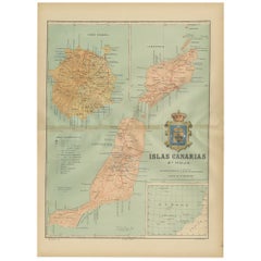
This is a authentic historical map of the Canary Islands, specifically the "1A HOJA" or first sheet, from the year 1902. The title on the map is "ISLAS CANARIAS 1902." This map features several of the main islands of the archipelago, including Tenerife, La Palma, La Gomera, and El Hierro.
The map includes topographical details with contour lines and color gradations to indicate varying elevations. There are symbols for provincial capitals, towns, roads, telegraph stations, and lighthouses. The Canary Islands are located in the Atlantic Ocean, off the northwest coast of Africa, and are known for their volcanic landscapes, diverse ecosystems, and rich cultural history.
Some notable features of the Canary Islands include:
1. **Teide Volcano**: Located on Tenerife, the Teide is the highest peak in Spain and the third highest volcano in the world measured from its base on the ocean floor.
2. **Biodiversity**: The islands are home to a wide range of microclimates and ecosystems, from subtropical forests to desert areas, hosting many unique plant and animal species.
3. **Cultural Fusion**: The culture of the Canary Islands is a mix of Spanish, African, and indigenous Guanche influences, reflected in their music, food, and traditions.
4. **Astronomical Observatories**: The clear skies of the Canary Islands make them an ideal location for astronomical observatories, including the Roque de los Muchachos Observatory on La Palma and the Teide Observatory on Tenerife.
5. **Laurel Forests**: The laurisilva or laurel forests on La Gomera and La Palma are ancient woodlands that date back to the Tertiary period.
6. **Beaches and Tourism**: The islands are famous for their beautiful beaches, attracting millions of tourists every year to resorts and natural spaces alike.
7. **Whistling Language**: On La Gomera, there is a unique whistled language called Silbo Gomero, which is used to communicate across the deep valleys and ravines.
8. **Pre-Hispanic History**: The indigenous Guanche people left behind a rich archaeological heritage, including the pyramids of Güímar on Tenerife and the cave paintings of La Palma.
"Islands of Fire and Whispers: The Canary Islands in 1902"
This title hints at the volcanic nature of the islands and the unique Silbo Gomero, capturing the essence of their geographical and cultural character.
- Dimensions:Height: 14.77 in (37.5 cm)Width: 20.08 in (51 cm)Depth: 0 in (0.02 mm)
- Materials and Techniques:
- Period:1900-1909
- Date of Manufacture:1902
- Condition:Good condition. Central vertical folding lines as issued. Aged paper with typically warm, yellowish-brown hue, especially around the edges and folding lines, adding to its patina. Check the images carefully.
- Seller Location:Langweer, NL
- Reference Number:
About the Seller
5.0
Platinum Seller
These expertly vetted sellers are 1stDibs' most experienced sellers and are rated highest by our customers.
Established in 2009
1stDibs seller since 2017
1,928 sales on 1stDibs
Typical response time: <1 hour
- ShippingRetrieving quote...Ships From: Langweer, Netherlands
- Return PolicyA return for this item may be initiated within 14 days of delivery.
More From This SellerView All
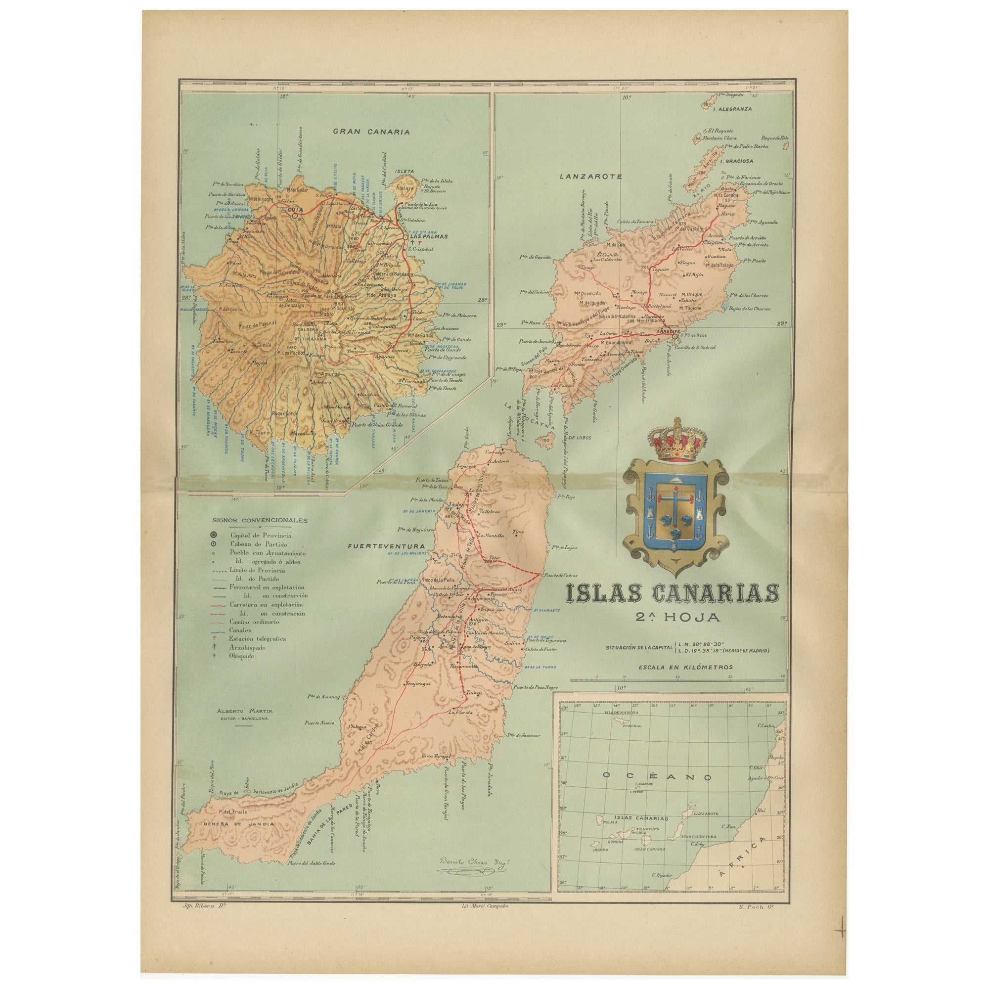
- Volcanic Eden: The Canary Islands’ Tapestry of Land and Sea in 1902Located in Langweer, NLThe map is the second sheet (2ª HOJA) of a historical map series of the Canary Islands from 1902. It depicts three of the major islands: Gran Canaria, Fuerteventura, and Lanzarote, a...Category
Antique Early 1900s Maps
MaterialsPaper
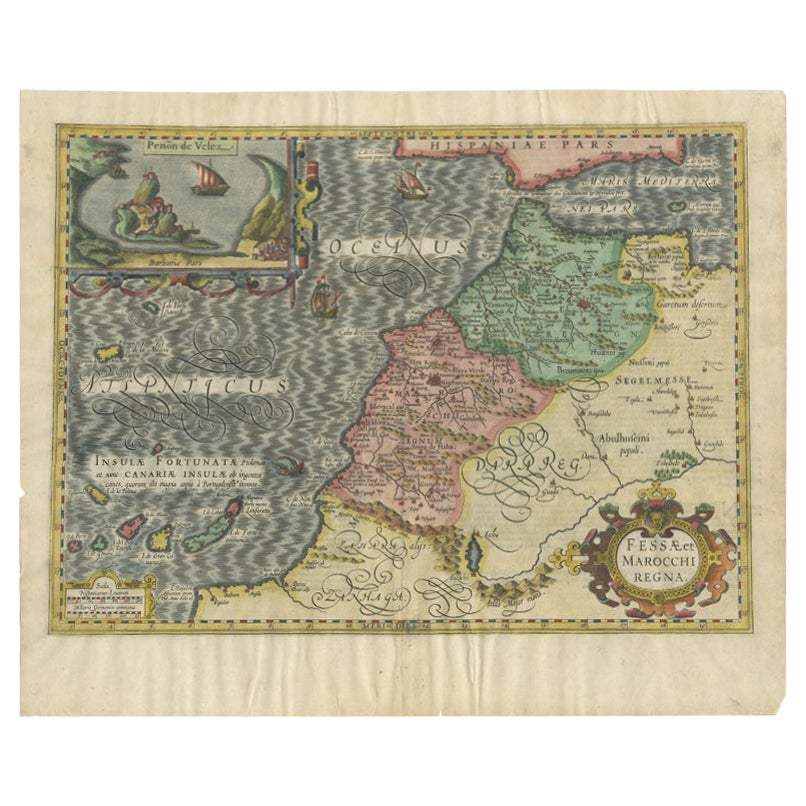
- Old Map of Morocco, The Canary Islands, Madeira, Inset of Penon de Velez, 1605Located in Langweer, NLAntique map titled 'Fessae et Marocchi Regna'. Original antique map of Morocco, extending south to Cape Bojador and , north to the Spanish Coast. Inset of Penon de Velez. Artists and...Category
Antique 17th Century Maps
MaterialsPaper
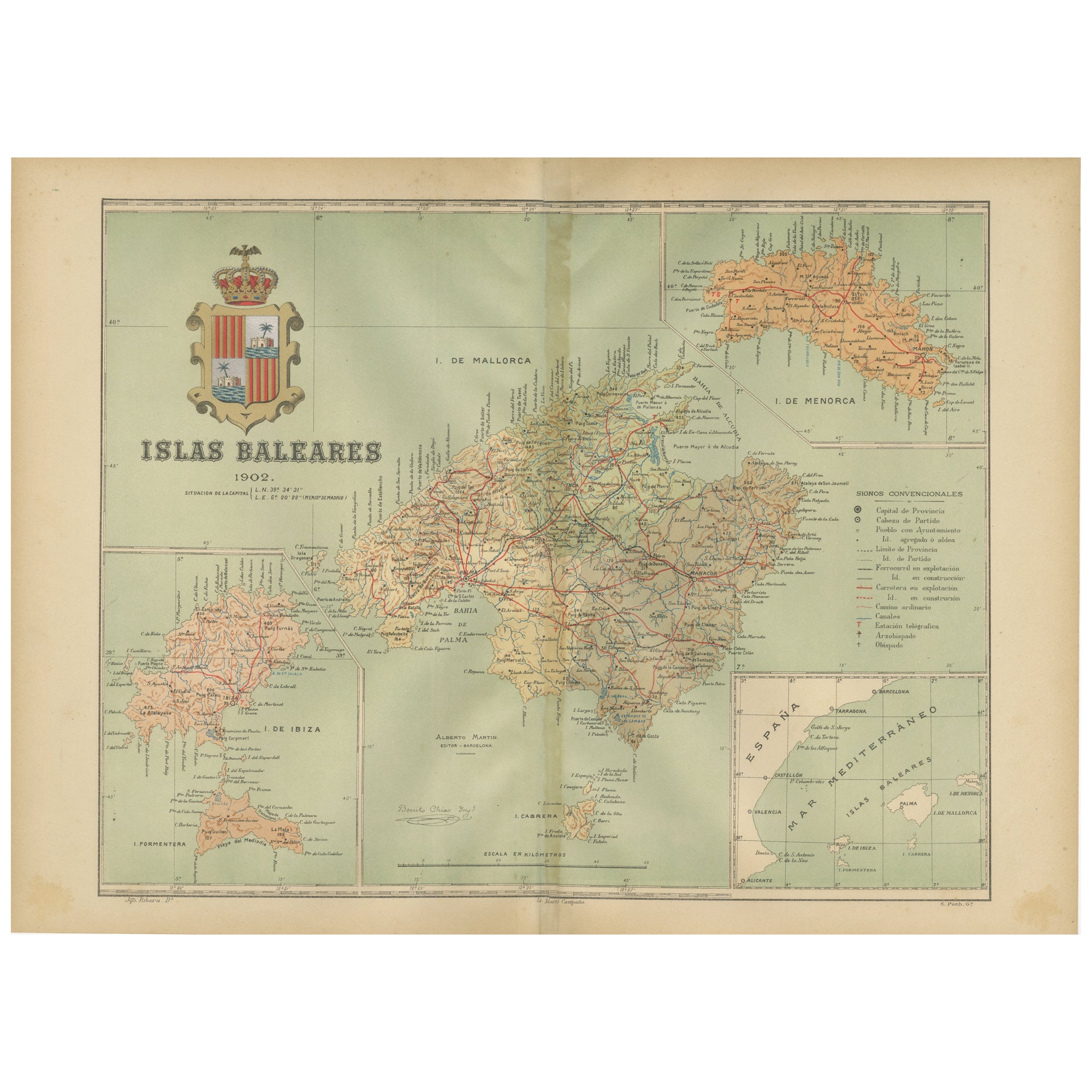
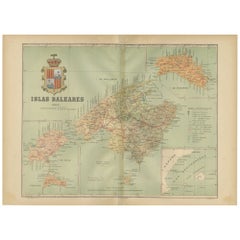
- Isles of Enchantment: The Balearic Archipelago in 1902Located in Langweer, NLThe Balearic Islands, Spain, from the year 1902. The title on the map is "ISLAS BALEARES 1902." This map illustrates the Balearic archipelago in the Mediterranean Sea, highlighting t...Category
Antique Early 1900s Maps
MaterialsPaper
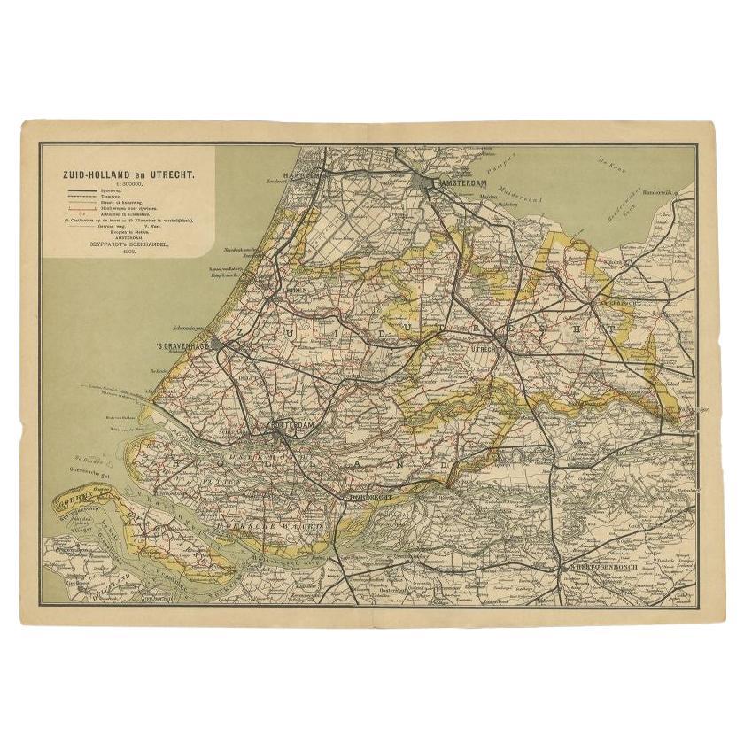
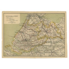
- Antique Map of Zuid-Holland and Utrecht in The Netherlands, 1902Located in Langweer, NLAntique map titled 'Zuid-Holland en Utrecht'. Lithographed map of the provinces of Zuid-Holland and Utrecht, the Netherlands. This map originates from 'Atlas van Nederland'. Artist...Category
20th Century Maps
MaterialsPaper
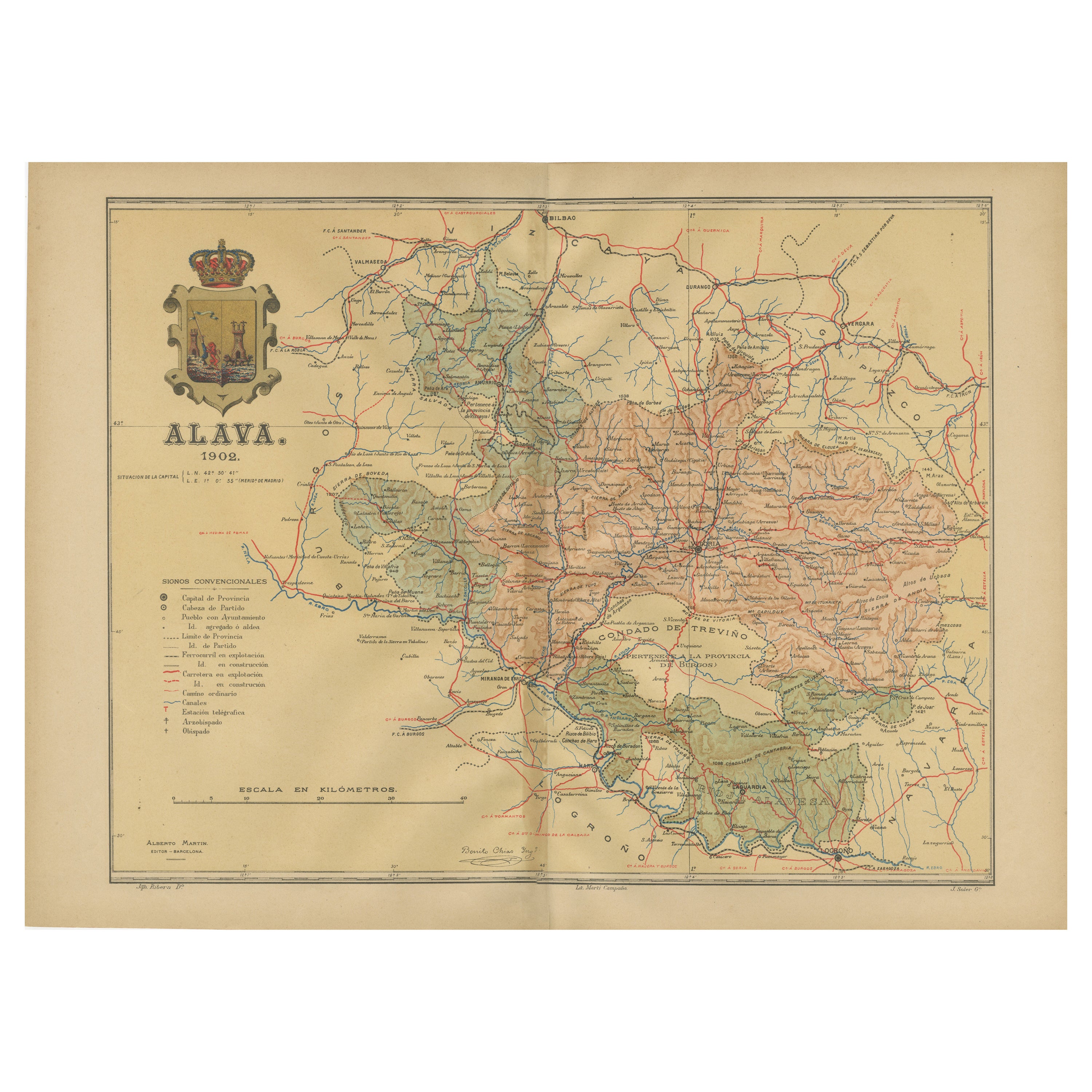
- Álava in Northern Spain: The Geography of Basque Heritage and Terrain, 1902Located in Langweer, NLThis original antique map is a historical depiction of the province of Álava (in Basque: Araba), which is one of the provinces of the Basque Country in northern Spain, as indicated b...Category
Antique Early 1900s Maps
MaterialsPaper
- Antique Map of the Islands Within the Queen Charlotte's IslandsLocated in Langweer, NLAntique map titled 'Cote Septentrional de la plus grande des Isles de la Reine Charlotte (..)'. Map and coastal view of the islands within the Queen Charlotte's Islands (Santa Cruz I...Category
Antique Late 18th Century Maps
MaterialsPaper


You May Also Like
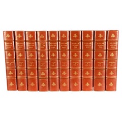
- 1902 The Complete Works of Edgar Allan PoeLocated in Bath, GBA beautiful limited edition set of the complete works of Edgar Allan Poe, illustrated with ten plates to each volume, and signed by the publisher. The Arnheim Edition of Poe's works...Category
Antique Early 1900s Books
MaterialsPaper
- 1865 Chart of the Islands of MadeiraLocated in Norwell, MARare James Imray chart from 1865 titled "Chart of the Islands of Madeira, Porto Santo and Dezerea" drawn from the survey made by Captain Ate Vidal Royal Navy, London. Published by Ja...Category
Antique 1860s European Maps
MaterialsPaper
- Original plans and projects for the redevelopment of Hursley Park: 1902 - 1904Located in SAINT-OUEN-SUR-SEINE, FRThis set of model elements accompanied by plans constitutes part of the project to redevelop the Hursley Park mansion, also called , commissioned by the Coopers family who acquired it in 1902. The project is entrusted to the architect Scottish Alexander Marshall Mackenzie (1848-1933). Originally built in the early 1720s, Hursley House was purchased in 1902 by Sir George Cooper and his wife Mary Emma Smith. Their desire to transform the place into an 18th century palace is perfectly illustrated by the purchase, to decorate their ballroom, of 18th century Beauvais tapestries. The decor was to highlight the French art collections of the Hursley Park mansion. The model elements that we present perfectly embody an eclectic taste for the arts of the 18th century, and in particular the ornamentation which simultaneously summons all the styles up to that of Louis XIV. The model, representing the decorations, allows you to see all the opulence of the interior of Hursley House. Large openings hosting tapestries, highlighted by richly decorated woodwork, frame large doors or mirrors displaying large garlands of flowers. The main model presents an interior design project for the “Grand Salon”. Another part of the models is dedicated to the representation of a bedroom of Mrs. Gould, on cardboard made by Tochon-Lepage & Cie. The model of the Grand Salon, probably an abandoned project of the Drawing Room which was actually completed, presents a sumptuous decoration in a Regency style. Rectangular in shape, the two longest walls of the room in turn present a decor decorated with tapestries and a series of three windows accompanied by a large mirror. The two smaller walls facing each other have on one side a fireplace topped...Category
Early 20th Century English Belle Époque Models and Miniatures
MaterialsPaper, Wood
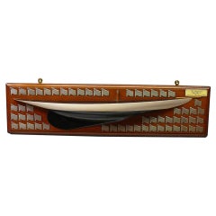
- Half Hull Model and Framed Photograph of the Yacht 'Barabel', circa 1902.Located in London, GBA rare builders half hull boat model of the 36 Linear Rater yacht Barabel, designed by A Mylne, Glasgow. The half hull boat model is made from solid timber, and painted cream to the waterline with painted caveta and black below, with a black deck. Bearing an ivorine plaque inscribed: Mr C.MacIver's "Barabel" 36LR designed by A Mylne, Glasgow on a mahogany backboard, set with 56 silver regatta prize flags, circa 1902-1904. The nautical half hull comes together with a framed photograph of Barabel sailing at sea. Alfred Mylne was apprenticed to the famous Scottish shipbuilders, Napier Shanks and Bell. He then worked as draftsman to G.L. Watson, where he was involved in drawing up the plans of the Royal Yacht "Britannia," the magnificent racing cutter that was first owned by the Prince of Wales [later King Edward VII] and which later passed to his son, King George V. Mylne set up his own office in 1896, which almost certainly makes the firm that still bears his name the world's oldest yacht design business in continuous production. Mylne immediately established a reputation as a designer of winning yachts, and was one of the people behind the most successful yacht handicap rules of all time - the International Metre Rule. Mylne designs were always admired for their elegance, and this was one of the attractions that drew owners to commission cruisers of every size from his design board...Category
Early 20th Century British Nautical Objects
MaterialsSterling Silver
- Hand-Colored 18th Century Homann Map of Denmark and Islands in the Baltic SeaBy Johann Baptist HomannLocated in Alamo, CAAn 18th century copper plate hand-colored map entitled "Insulae Danicae in Mari Balthico Sitae utpote Zeelandia, Fionia, Langelandia, Lalandia, Falstria, Fembria Mona" created by Joh...Category
Antique Early 18th Century German Maps
MaterialsPaper
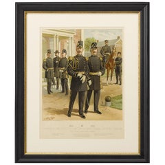
- Original "1902-1907 Officers of the Staff Corps" by C. Ogden, 1908Located in Colorado Springs, CO1908 "1902-1907 Officers of the Staff Corps & Departments, General Staff and Chaplain in Full Dress" Chromolithograph by C. Ogden This colorful lithograph by H. A. Ogden was publish...Category
Antique Early 1900s American Prints
MaterialsPaper


Recently Viewed
View AllMore Ways To Browse
Map Of Old Armenia
Teak Wood Sphere
Nova Guinea Maps
Antique Map Of Illinois
Petite Point Hand Bag
Antique Map Of Southeastern Us
Antique Map Alabama
Antique Map Of Sydney
Malay Archipelago Map
Gambia Antique Map
Uruguay Antique Map
Guyana Antique Map
Ruscelli Map
Masque Theatre No
Nova Scotia Map
Antique Map Tuscany
Berkshire Antique Map
Cornwall Map