Items Similar to Cádiz 1901: Nautical Crossroads of the Atlantic and Mediterranean


Want more images or videos?
Request additional images or videos from the seller
1 of 6
Cádiz 1901: Nautical Crossroads of the Atlantic and Mediterranean
$402.92
$503.6620% Off
£299.73
£374.6720% Off
€336
€42020% Off
CA$551.74
CA$689.6820% Off
A$613.46
A$766.8320% Off
CHF 320.32
CHF 400.3920% Off
MX$7,467.31
MX$9,334.1420% Off
NOK 4,087.08
NOK 5,108.8620% Off
SEK 3,829.40
SEK 4,786.7520% Off
DKK 2,557.78
DKK 3,197.2320% Off
Shipping
Retrieving quote...The 1stDibs Promise:
Authenticity Guarantee,
Money-Back Guarantee,
24-Hour Cancellation
About the Item
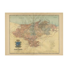
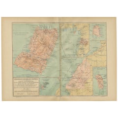
The map illustrates the province of Cádiz, located in the autonomous community of Andalusia, Spain, from the year 1901. It displays various geographic and man-made features:
The map depicts the varied landscape of Cádiz, including the mountainous regions, such as the Sierra de Grazalema, and the lower elevation areas closer to the coast. The map details the extensive coastline that Cádiz has along both the Atlantic Ocean and the Mediterranean Sea, including the Strait of Gibraltar. Blue lines mark the rivers, such as the Guadalquivir River which borders the province to the north. Red lines represent the roads and railways, which show how the province is connected internally and with the surrounding regions. Various symbols indicate the locations of cities and towns, with the capital city of Cádiz possibly highlighted. Dotted lines may represent the borders of Cádiz province within Andalusia. The map includes a legend (Signos Convencionales) that explains the symbols used for provincial capitals, roads, railways, and boundaries. There is a scale in kilometers at the bottom for distance measurement.
The coat of arms of Cádiz is prominently displayed, featuring Hercules and two lions in silver plated print, which are symbols deeply associated with the mythological foundation of the city and the region. The crown is highlighted with gold.
About the province of Cádiz:
Cádiz is one of the oldest continuously inhabited cities in Western Europe, with a rich history that includes Phoenician, Roman, and Moorish influences. The province is known for its beautiful beaches, such as those of Tarifa, which are popular for windsurfing and kitesurfing due to the strong winds in the Strait of Gibraltar. The region is also famous for its Sherry wine production, particularly in the towns of Jerez de la Frontera, El Puerto de Santa María, and Sanlúcar de Barrameda. The province's cultural heritage is celebrated through its annual carnivals, especially the one in the city of Cádiz, which is among the most famous in Spain. The local cuisine features seafood prominently, with dishes like "pescaíto frito" (fried fish) being a local staple. Cádiz is also known for its contributions to flamenco music and dance.
- Dimensions:Height: 14.77 in (37.5 cm)Width: 20.08 in (51 cm)Depth: 0 in (0.02 mm)
- Materials and Techniques:
- Period:1900-1909
- Date of Manufacture:1901
- Condition:Good condition. Central vertical folding lines as issued. Aged paper with typically warm, yellowish-brown hue, especially around the edges. Check the images carefully.
- Seller Location:Langweer, NL
- Reference Number:Seller: BG-13642-101stDibs: LU3054338031552
About the Seller
5.0
Recognized Seller
These prestigious sellers are industry leaders and represent the highest echelon for item quality and design.
Platinum Seller
Premium sellers with a 4.7+ rating and 24-hour response times
Established in 2009
1stDibs seller since 2017
2,510 sales on 1stDibs
Typical response time: <1 hour
- ShippingRetrieving quote...Shipping from: Langweer, Netherlands
- Return Policy
Authenticity Guarantee
In the unlikely event there’s an issue with an item’s authenticity, contact us within 1 year for a full refund. DetailsMoney-Back Guarantee
If your item is not as described, is damaged in transit, or does not arrive, contact us within 7 days for a full refund. Details24-Hour Cancellation
You have a 24-hour grace period in which to reconsider your purchase, with no questions asked.Vetted Professional Sellers
Our world-class sellers must adhere to strict standards for service and quality, maintaining the integrity of our listings.Price-Match Guarantee
If you find that a seller listed the same item for a lower price elsewhere, we’ll match it.Trusted Global Delivery
Our best-in-class carrier network provides specialized shipping options worldwide, including custom delivery.More From This Seller
View AllMaritime and Terrestrial Survey of Spanish Santander in 1901, An Original Map
Located in Langweer, NL
This antique map is a historical map of the province of Santander (currently known as Cantabria) from the year 1901. Santander is located along the northern coast of Spain, bordering...
Category
Antique Early 1900s Maps
Materials
Paper
$277 Sale Price
20% Off
Free Shipping
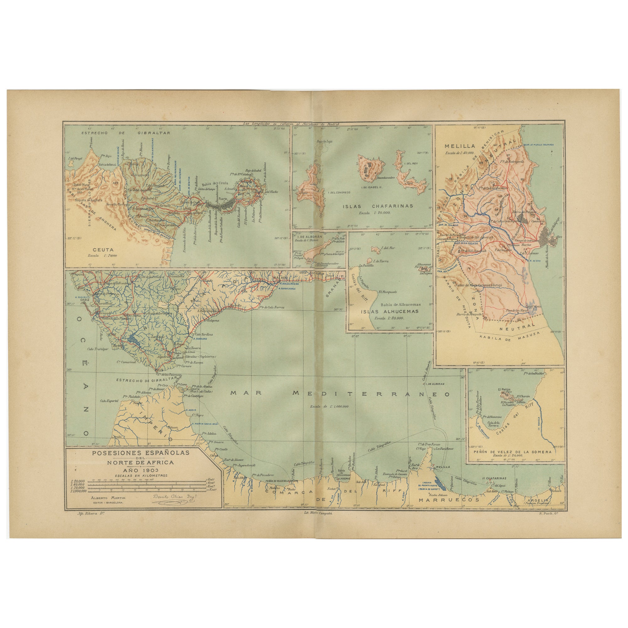
Crossroads of Continents: Spain's North African Enclaves in 1903
Located in Langweer, NL
The image for sale is a historical map of Spanish possessions in North Africa, dated 1903. The map includes the enclaves of Ceuta and Melilla, the Chafarinas Islands, the Alhucemas I...
Category
Antique Early 1900s Maps
Materials
Paper
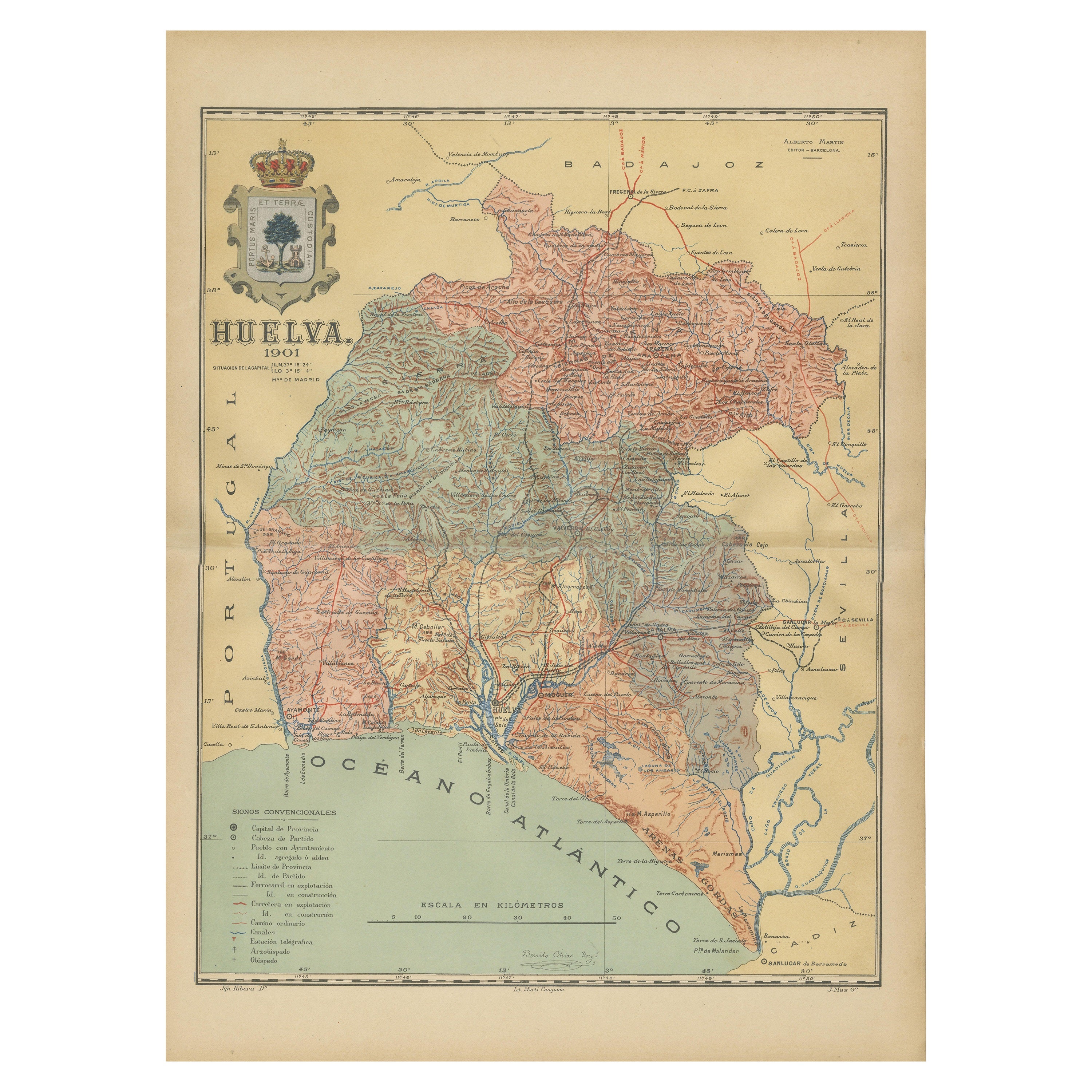
Huelva 1901: A Cartographic Presentation of Andalusia's Atlantic Frontier
Located in Langweer, NL
The map displays the province of Huelva, located in the southwestern part of the autonomous community of Andalusia in Spain, as of the year 1901. It outlines various geographic and m...
Category
Antique Early 1900s Maps
Materials
Paper

$345 Sale Price
20% Off
Free Shipping
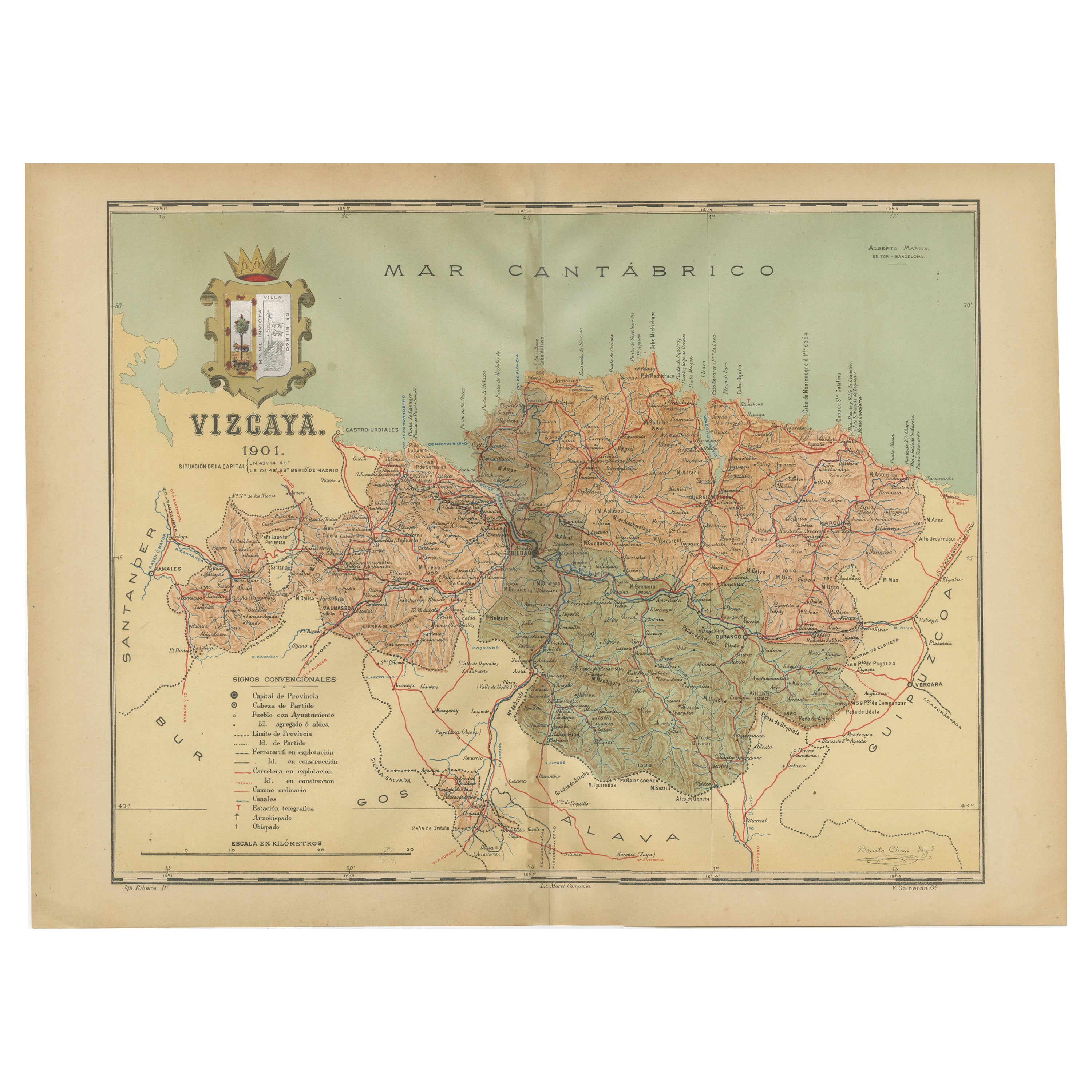
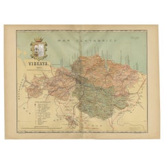
Cartographic Heritage: The 1901 Map of the Vizcaya Province in Spain
Located in Langweer, NL
This is a historical map of the province of Vizcaya (Biscay) in Spain, dated 1901. The title on the map is "VIZCAYA. 1901." It shows the topographical details of the region with cont...
Category
Antique Early 1900s Maps
Materials
Paper
$306 Sale Price
20% Off
Free Shipping
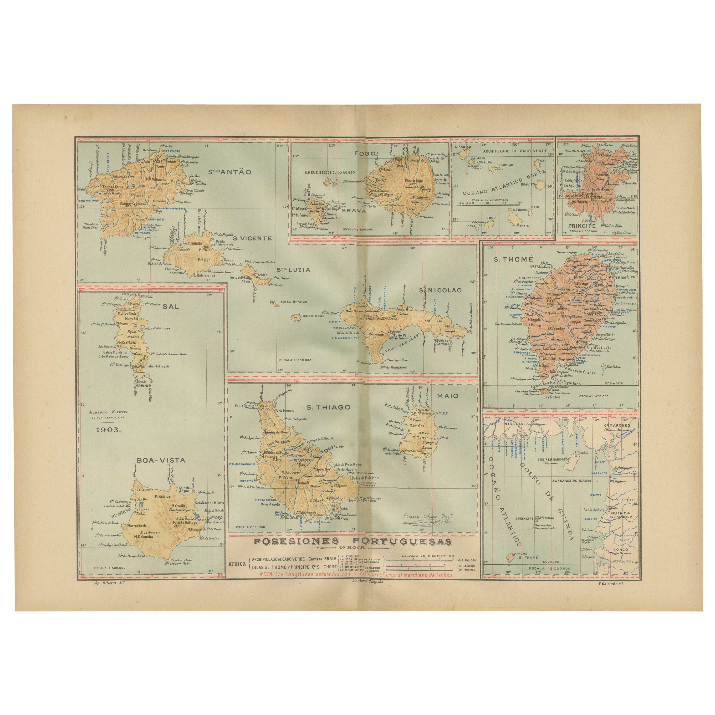
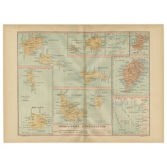
Islands of Diversity: Portugal's Atlantic Archipelagos in 1903
Located in Langweer, NL
The image is an original historical map from 1903 depicting Portuguese possessions in the Atlantic Ocean, specifically the islands of Cape Verde and the islands of São Tomé and Prínc...
Category
Antique Early 1900s Maps
Materials
Paper
Echoes of Empire: Spanish Territories in West Africa, 1903
Located in Langweer, NL
This is a historical map showing Spanish possessions in West Africa from the year 1903. The map includes the islands of Fernando Póo (now known as Bioko), part of the modern-day country of Equatorial Guinea, Annobón Island, and the Elobey Islands, along with the Spanish-controlled areas on the continental region near Rio Muni.
These territories were part of Spain's colonial empire and are situated in the Gulf of Guinea, off the coast of Central Africa. Fernando Póo (Bioko) is particularly notable for its volcanic origins and as a center of cocoa production during the colonial period. Annobón, lying further southwest of Bioko, is a small volcanic island. The Elobey Islands are very small and located near the coast of Gabon.
Here's a brief overview of their significance:
1. **Bioko Island (Fernando Póo)**: The island has a rich biodiversity and is known for its unique flora and fauna, including several endemic species. Malabo, the capital city of Equatorial Guinea, is located here.
2. **Annobón Island**: This remote island has a small population and is known for its isolation and distinctive Creole culture, which has developed independently from the mainland.
3. **Elobey Islands**: These consist of Elobey Grande and Elobey Chico and are situated near the mouths of the Muni and Campo rivers. They were historically important as transit points in river trade...
Category
Antique Early 1900s Maps
Materials
Paper
You May Also Like
Geographical Antique Map of Principality of Monaco
By Bruno Santini
Located in Alessandria, Piemonte
ST/609 - Interesting antique color map of Monaco Principality in French language : "Carte qui contient le Principauté de Piémont, le Monferrat et la comté de...
Category
Antique Late 18th Century Italian Other Maps
Materials
Paper

Map Sussex
Located in BUNGAY, SUFFOLK
Map of Sussex with explanation
Maker unknown.
Category
Antique 19th Century English Victorian Maps
Materials
Paper

$822
1898 Chart of Boston Bay
Located in Norwell, MA
Original 1898 chart showing Massachusetts Bay with the coast from Cape Ann to Cape Cod. This is a U.S. Navy Geodetic survey chart. All towns are noted along the coast. Framed with gl...
Category
Antique 1890s Nautical Objects
Materials
Paper

$1,495
Large Original Vintage Map of Spain, circa 1920
Located in St Annes, Lancashire
Great map of Spain
Original color.
Good condition
Published by Alexander Gross
Unframed.
Category
Vintage 1920s English Maps
Materials
Paper

Large Original Antique Map of The Canary Islands. 1894
Located in St Annes, Lancashire
Superb Antique map of The Canary Islands
Published Edward Stanford, Charing Cross, London 1894
Original colour
Good condition
Unframed.
Free shipping
Category
Antique 1890s English Maps
Materials
Paper

Map Huntingdonshire R Scott Archibald Fullarton & Co Glasgow
Located in BUNGAY, SUFFOLK
Folding Map of Huntingdonshire by R Scott with distances from London and reference to the hundreds.
Published by Archibald Fullarton & Co Glasgow. Measure: 40...
Category
Antique 19th Century English Victorian Maps
Materials
Paper

More Ways To Browse
Mediterranean Antique
Lion And Crown
Railway Map
Antique Sherry
North Wind Antique Furniture
Spanish Andalusia
Spanish Silver Lion
Scale Carnival
Antique Oushak
Mid Century Danish Directors Chairs
Moller 70
Argentina Travel Poster
Century Furniture Faux Bamboo
Early American Chairs
Hans Muller
Vintage Wood Table With Glass Top
19th Century Square Table
Antonio Bonet