Items Similar to French Antique Map of Oceania with Details of the Australian Colonies, c.1840


Want more images or videos?
Request additional images or videos from the seller
1 of 6
French Antique Map of Oceania with Details of the Australian Colonies, c.1840
$210.87
$263.5920% Off
£156.98
£196.2320% Off
€176
€22020% Off
CA$288.84
CA$361.0520% Off
A$321.26
A$401.5720% Off
CHF 167.75
CHF 209.6920% Off
MX$3,909.36
MX$4,886.7020% Off
NOK 2,142.43
NOK 2,678.0420% Off
SEK 2,009.22
SEK 2,511.5320% Off
DKK 1,339.83
DKK 1,674.7820% Off
Shipping
Retrieving quote...The 1stDibs Promise:
Authenticity Guarantee,
Money-Back Guarantee,
24-Hour Cancellation
About the Item
Antique map Oceania titled 'Océanie par C.V. Monin'. Old map of Oceania with an inset of New South Wales. Originates from 'Atlas Classique de la Géographie Ancienne (..)'.
Artists and Engravers: Engraved by Laguillermie.
Condition: Very good, general age-related toning and wear. Please study image carefully.
Date: c.1840
Overall size: 44.5 x 33 cm.
Image size: 39.5 x 28 cm.
We sell original antique maps to collectors, historians, educators and interior decorators all over the world. Our collection includes a wide range of authentic antique maps from the 16th to the 20th centuries. Buying and collecting antique maps is a tradition that goes back hundreds of years. Antique maps have proved a richly rewarding investment over the past decade, thanks to a growing appreciation of their unique historical appeal. Today the decorative qualities of antique maps are widely recognized by interior designers who appreciate their beauty and design flexibility. Depending on the individual map, presentation, and context, a rare or antique map can be modern, traditional, abstract, figurative, serious or whimsical. We offer a wide range of authentic antique maps for any budget.
- Dimensions:Height: 13 in (33 cm)Width: 17.52 in (44.5 cm)Depth: 0 in (0.01 mm)
- Materials and Techniques:
- Period:
- Date of Manufacture:c.1840
- Condition:Condition: Very good, general age-related toning and wear. Please study image carefully.
- Seller Location:Langweer, NL
- Reference Number:Seller: BGJC-2231stDibs: LU3054329623352
About the Seller
5.0
Recognized Seller
These prestigious sellers are industry leaders and represent the highest echelon for item quality and design.
Platinum Seller
Premium sellers with a 4.7+ rating and 24-hour response times
Established in 2009
1stDibs seller since 2017
2,510 sales on 1stDibs
Typical response time: <1 hour
- ShippingRetrieving quote...Shipping from: Langweer, Netherlands
- Return Policy
Authenticity Guarantee
In the unlikely event there’s an issue with an item’s authenticity, contact us within 1 year for a full refund. DetailsMoney-Back Guarantee
If your item is not as described, is damaged in transit, or does not arrive, contact us within 7 days for a full refund. Details24-Hour Cancellation
You have a 24-hour grace period in which to reconsider your purchase, with no questions asked.Vetted Professional Sellers
Our world-class sellers must adhere to strict standards for service and quality, maintaining the integrity of our listings.Price-Match Guarantee
If you find that a seller listed the same item for a lower price elsewhere, we’ll match it.Trusted Global Delivery
Our best-in-class carrier network provides specialized shipping options worldwide, including custom delivery.More From This Seller
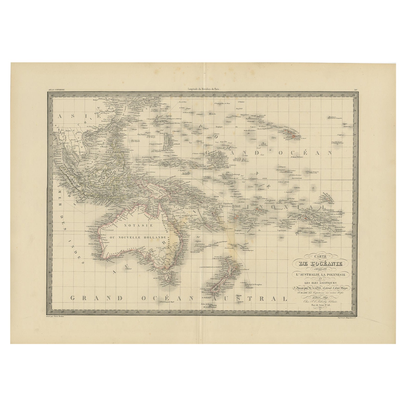
View AllAntique Map of Oceania by Lapie, 1842
Located in Langweer, NL
Antique map titled 'Carte de l'Océanie contenant l'Australie, la Polynesie et les Iles Asiatiques'. Map of Oceania including Australia, Polynesia and several islands of Asia. This ma...
Category
Antique 19th Century Maps
Materials
Paper
$249 Sale Price
20% Off
Antique Map of Oceania by Balbi '1847'
Located in Langweer, NL
Antique map titled 'Océanie'. Original antique map of Oceania. This map originates from 'Abrégé de Géographie (..)' by Adrien Balbi. Published 1847.
Category
Antique Mid-19th Century Maps
Materials
Paper

$143 Sale Price
20% Off
Antique Map of Australia and Polynesia, inset of Tasmania c.1860
Located in Langweer, NL
German antique map titled 'Australien und Polynesien'. Old map of Australia (New Holland) and Polynesia. With an inset map of Southern Australia including Tasmania (Van Diemen's Land...
Category
Antique 19th Century Maps
Materials
Paper

$115 Sale Price
20% Off
Mid-19th Century Map of Australasia by Carl Flemming - 1855
Located in Langweer, NL
Title: "Mid-19th Century Map of Australasia by Carl Flemming - 1855"
Description: This original 1855 antique map from the Sohr-Berghaus Atlas, created by Carl Flemming, is a detaile...
Category
Antique 1850s Maps
Materials
Paper

Antique Map of Australia and surrounding Islands by F. von Stülpnagel, 1850
Located in Langweer, NL
Antique map titled 'Festland von Asutralien und benachbarte Inseln'. Map showing Australia, New Zealand, Southern New-Guinea and surrounding islands. This map originates from Stieler...
Category
Antique Mid-19th Century Maps
Materials
Paper

$184 Sale Price
30% Off
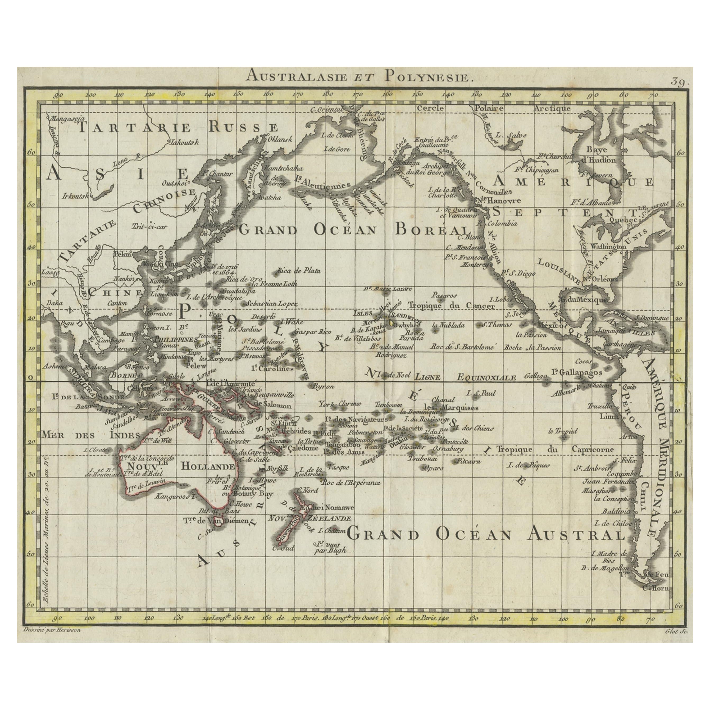
Antique French Map of the Pacific Ocean with Australia and Polynesia, 1806
Located in Langweer, NL
Antique map titled 'Australasie et Polynesie'. Old map of Oceania and the Pacific Ocean. Originates from 'Atlas Portatif contenant la Géographie Universelle Ancienne et Moderne' by H...
Category
Antique 19th Century Maps
Materials
Paper
$115 Sale Price
20% Off
You May Also Like
Large Original Antique Map of Australia by Sidney Hall, 1847
Located in St Annes, Lancashire
Great map of Australia
Drawn and engraved by Sidney Hall
Steel engraving
Original colour outline
Published by A & C Black. 1847
Unframed
Free shipping.
Category
Antique 1840s Scottish Maps
Materials
Paper

Original Antique Map of Australia by Dower, circa 1835
Located in St Annes, Lancashire
Nice map of Australia
Drawn and engraved by J.Dower
Published by Orr & Smith. C.1835
Unframed.
Free shipping
Category
Antique 1830s English Maps
Materials
Paper

Large Original Antique Map of The Pacific Ocean, Fullarton, C.1870
Located in St Annes, Lancashire
Great map of The Pacific Ocean
From the celebrated Royal Illustrated Atlas
Lithograph by Swanston. Original color.
Published by Fullarton,...
Category
Antique 1870s Scottish Maps
Materials
Paper

Ancient Map of Oceania - Original Etching - 19th century
Located in Roma, IT
This Map of Oceania is an etching realized in the 19th century.
The state of preservation of the artwork is good. At the top of the paper, the inscription “Longitudine del Meridiano...
Category
19th Century More Prints
Materials
Etching

1850 Old French Map Depicting the Entire Earth's Surface Divided into Two Parts
Located in Milan, IT
Geographical map depicting the entire earth's surface divided into two parts that correspond to the two hemispheres where the emerged lands are depicted which have been classified wi...
Category
Antique Mid-19th Century French Maps
Materials
Glass, Wood, Paper

Original Antique Map of The World by Thomas Clerk, 1817
Located in St Annes, Lancashire
Great map of The Eastern and Western Hemispheres
On 2 sheets
Copper-plate engraving
Drawn and engraved by Thomas Clerk, Edinburgh.
Published by Mackenzie And Dent, 1817
...
Category
Antique 1810s English Maps
Materials
Paper

More Ways To Browse
Peninsular War
Ukraine Antique Map
Antique Life Buoy
Antique Map Nova Scotia
Antique Map Of Argentina
Antique Maps Of Kansas
Cambodia Antique Map
Magellan Map
Map Ukraine
Mariners Chart
Papua New Guinea Antique Map
Bermuda Map
Scan Globe
Tunisia Antique Map
Antique Map New Orleans
Antique Maps Of Maryland
Gambia Antique Map
Antique Manitoba