Items Similar to Antique Map of Australia and Polynesia, inset of Tasmania c.1860
Want more images or videos?
Request additional images or videos from the seller
1 of 5
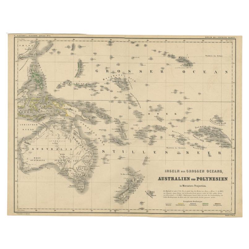
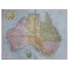
Antique Map of Australia and Polynesia, inset of Tasmania c.1860
About the Item
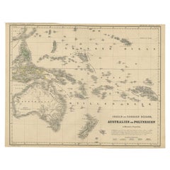
German antique map titled 'Australien und Polynesien'. Old map of Australia (New Holland) and Polynesia. With an inset map of Southern Australia including Tasmania (Van Diemen's Land). This map originates from Stieler's 'Schul-Atlas'. Lower left corner a list of mountains with heights.
Artists and Engravers: Engraved by H. Berghaus.
We sell original antique maps to collectors, historians, educators and interior decorators all over the world. Our collection includes a wide range of authentic antique maps from the 16th to the 20th centuries. Buying and collecting antique maps is a tradition that goes back hundreds of years. Antique maps have proved a richly rewarding investment over the past decade, thanks to a growing appreciation of their unique historical appeal. Today the decorative qualities of antique maps are widely recognized by interior designers who appreciate their beauty and design flexibility. Depending on the individual map, presentation, and context, a rare or antique map can be modern, traditional, abstract, figurative, serious or whimsical. We offer a wide range of authentic antique maps for any budget.
- Dimensions:Height: 8.67 in (22 cm)Width: 10.83 in (27.5 cm)Depth: 0 in (0.01 mm)
- Materials and Techniques:
- Period:
- Date of Manufacture:circa 1860
- Condition:Condition: Good, general age-related toning. Some wear, please study image carefully.
- Seller Location:Langweer, NL
- Reference Number:
About the Seller
5.0
Platinum Seller
These expertly vetted sellers are 1stDibs' most experienced sellers and are rated highest by our customers.
Established in 2009
1stDibs seller since 2017
1,929 sales on 1stDibs
Typical response time: <1 hour
- ShippingRetrieving quote...Ships From: Langweer, Netherlands
- Return PolicyA return for this item may be initiated within 14 days of delivery.
More From This SellerView All
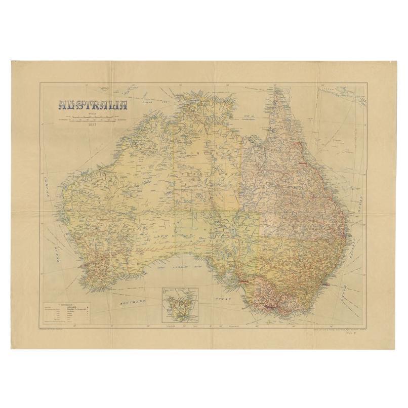
- Large Detailed Map of Australia Wint Inset of Tasmania, 1937Located in Langweer, NLAntique map titled 'Australia'. Large folding map of Australia. With inset map of Tasmania. Printed by L.F. Johnston, Canberra. Artists and Engravers: Compiled and drawn by Propert...Category
20th Century Maps
MaterialsPaper
- German Antique Map of Australia and Polynesia, c.1870Located in Langweer, NLAntique map titled 'Inseln des Grossen Oceans, Australien und Polynesien'. Old map of Australia and Polynesia. This map originates from 'H. Kiepert's Kleiner Atlas der Neueren Geogra...Category
Antique 19th Century Maps
MaterialsPaper
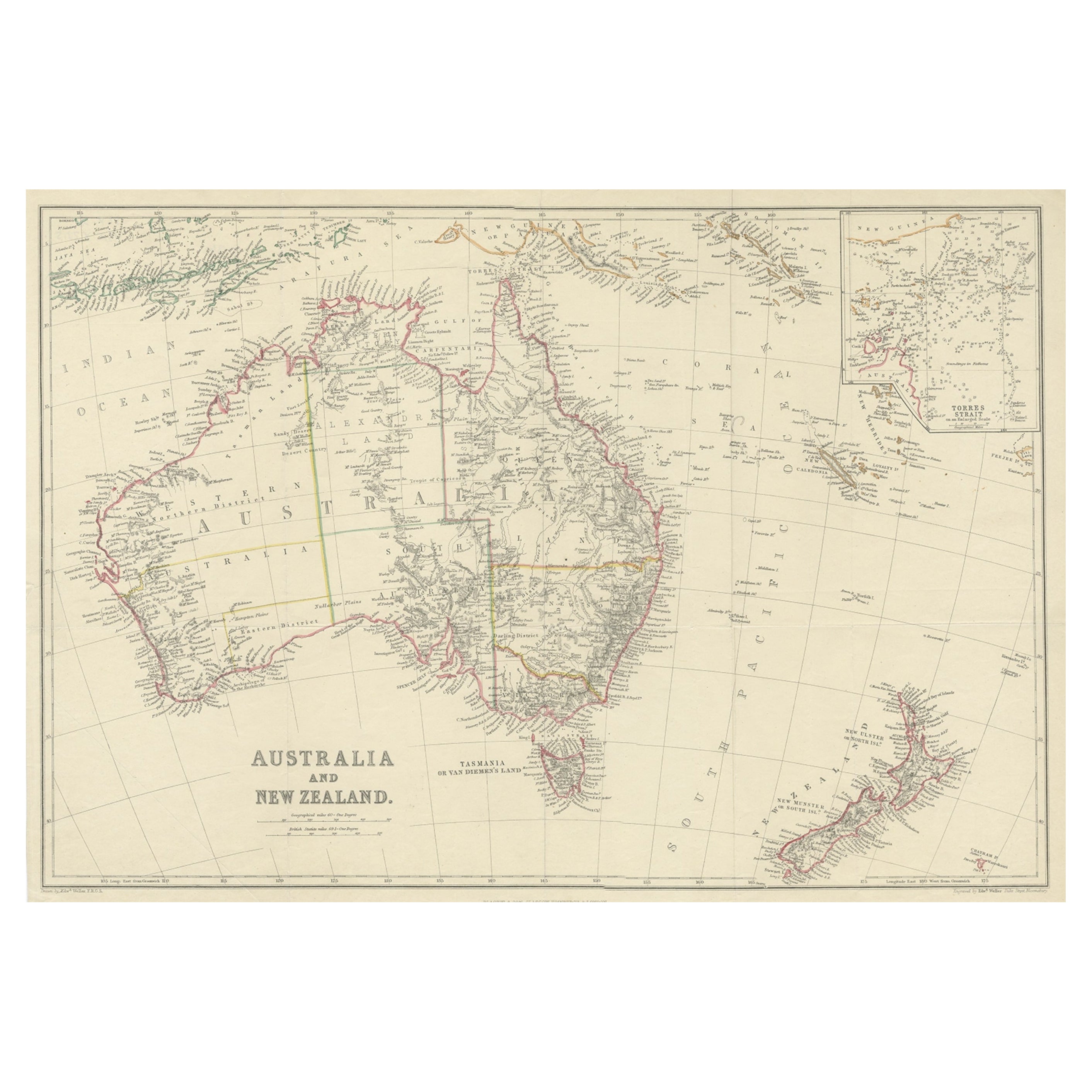
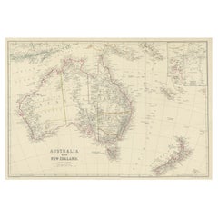
- Antique Map of Australia and New Zealand, c.1860Located in Langweer, NLAntique map titled 'Australia and New Zealand'. Unusual edition of this map of Australia and New Zealand, on very thin paper and multiple folding lines. Source unknown, to be determi...Category
Antique 19th Century Maps
MaterialsPaper
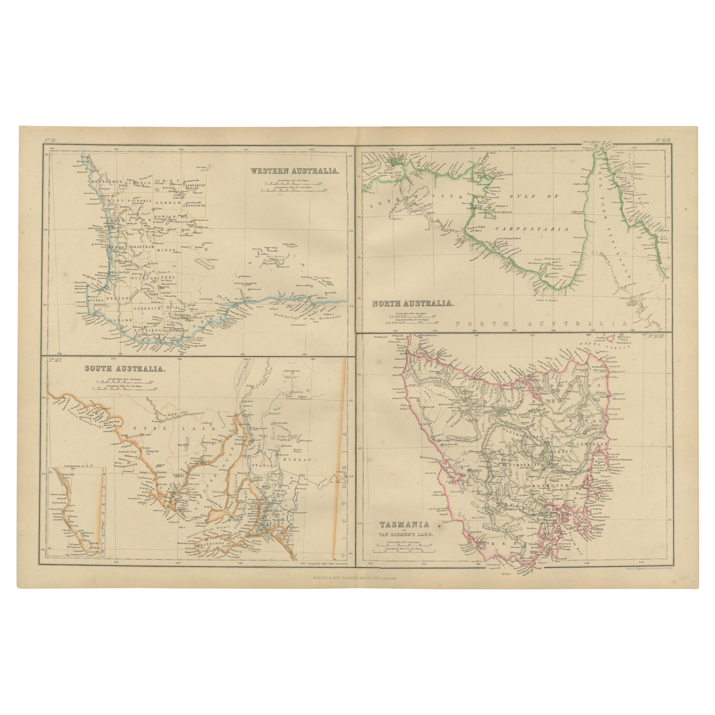
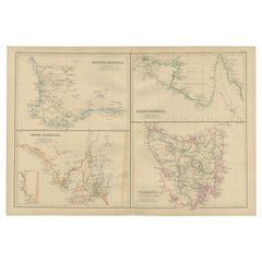
- Antique Map of West, South, North Australia and Tasmania by W. G. Blackie, 1859Located in Langweer, NLAntique map titled 'Western Australia, South Australia, North Australia and Tasmania'. Original antique map of Western Australia, South Australia, North Australia and Tasmania. This ...Category
Antique Mid-19th Century Maps
MaterialsPaper
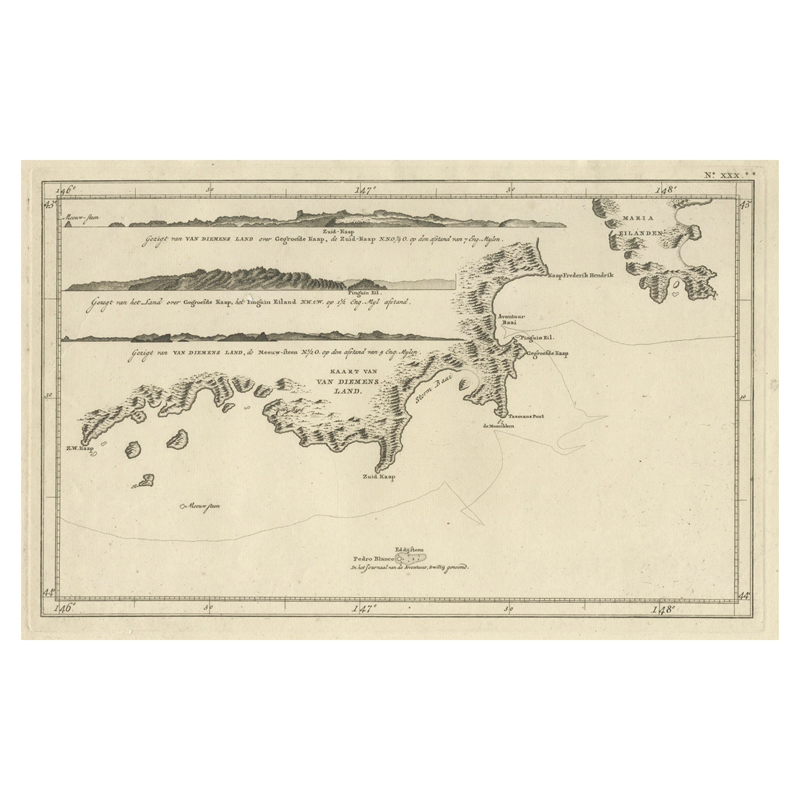
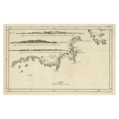
- Antique Coastal Views and a Map of Van Diemens Land (Tasmania), Australia, 1803Located in Langweer, NLAntique map Tasmania titled 'Kaart van Diemens Land'. Coastal views and a map of van Diemens Land (Tasmania). Originates from 'Reizen Rondom de Waereld ...Category
Antique Early 1800s Maps
MaterialsPaper
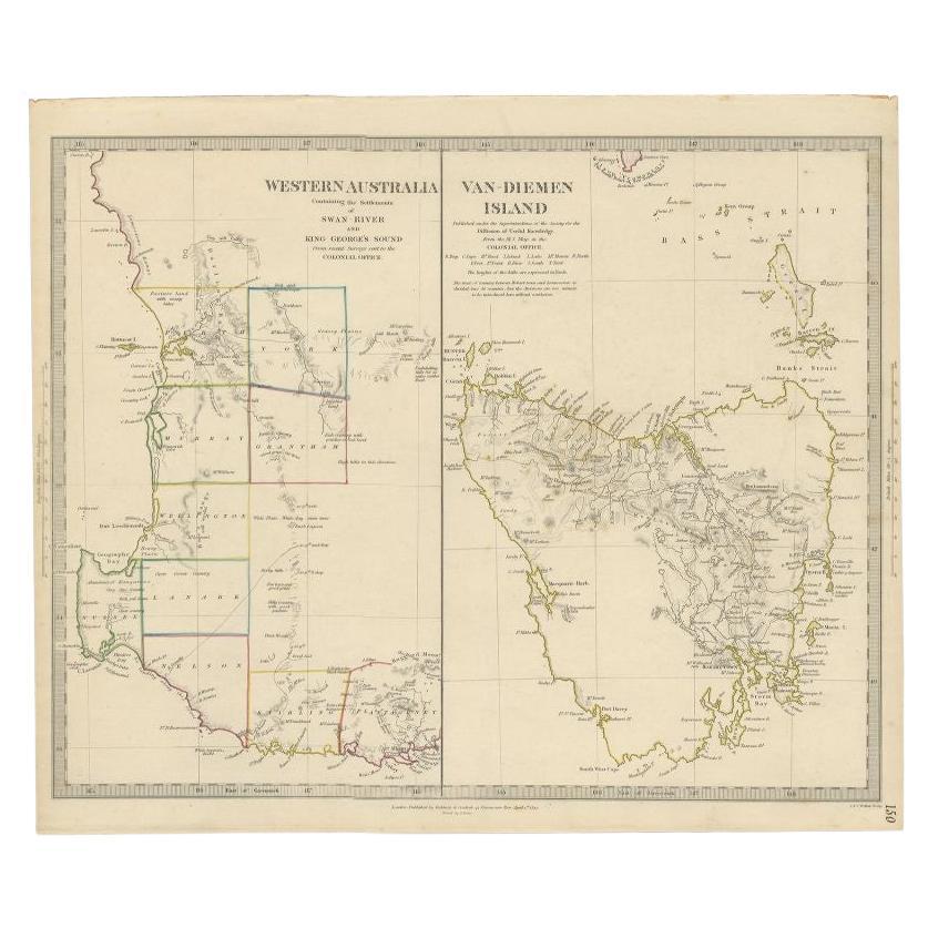
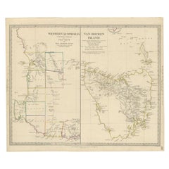
- Antique Map of Western Australia and Van Diemen's Land or Tasmania, 1833Located in Langweer, NLAntique map of Australia titled 'Western Australia - Van-Diemen Island'. Two maps on one sheet. Left, Western Australia containing the settlements of the Swan river...Category
Antique 19th Century Maps
MaterialsPaper

You May Also Like
- Large Original Antique Map of Australia, Fullarton, C.1870Located in St Annes, LancashireGreat map of Australia From the celebrated Royal Illustrated Atlas Engraved by Swanston after the drawing by Augustus Petermann Lithograph. Original color. Published by ...Category
Antique 1870s Scottish Maps
MaterialsPaper
- Large Original Antique Map of Australia by Sidney Hall, 1847Located in St Annes, LancashireGreat map of Australia Drawn and engraved by Sidney Hall Steel engraving Original colour outline Published by A & C Black. 1847 Unframed Free shipping.Category
Antique 1840s Scottish Maps
MaterialsPaper
- Antique Lithography Map, Northamptonshire, English, Framed Cartography, C.1860Located in Hele, Devon, GBThis is an antique lithography map of Northamptonshire. An English, framed atlas engraving of cartographic interest, dating to the mid 19th century...Category
Antique Mid-19th Century British Victorian Maps
MaterialsWood
- Antique County Map, Rutlandshire, English, Framed, Cartography, Victorian, 1860Located in Hele, Devon, GBThis is an antique lithography map of Rutlandshire. An English, framed atlas engraving of cartographic interest, dating to the mid 19th century and later. Superb lithography of Rutl...Category
Antique Mid-19th Century British Victorian Maps
MaterialsWood
- Large Original Vintage Map of Australia, circa 1920Located in St Annes, LancashireGreat map of Australia Original color. Good condition Published by Alexander Gross Unframed.Category
Vintage 1920s English Maps
MaterialsPaper
- Large Original Vintage Map of Queensland, Australia, circa 1920Located in St Annes, LancashireGreat map of Queensland Original color. Good condition Published by Alexander Gross Unframed.Category
Vintage 1920s English Edwardian Maps
MaterialsPaper


Recently Viewed
View AllMore Ways To Browse
German Antiques
Germany Antiques
List Of Interior Designers
Antique Australia
Australian Designer Furniture
20 C Design
Australian Antiques
Southern New And Used Furniture
Australia 19th Century
Australian Antique Furniture
Australia Antique Furniture
Map Australia
Maps Of Australia
19th Century Australian Furniture
Antique Collectables Australia
Antique Maps Australia
Antique Map Australia
Australia Antique Map