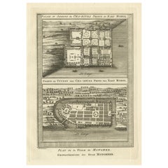
Items Similar to Palace & Gardens of Shah Shuja, Prince of Rajmahal & Munger, India, 1757

Want more images or videos?
Request additional images or videos from the seller
1 of 7
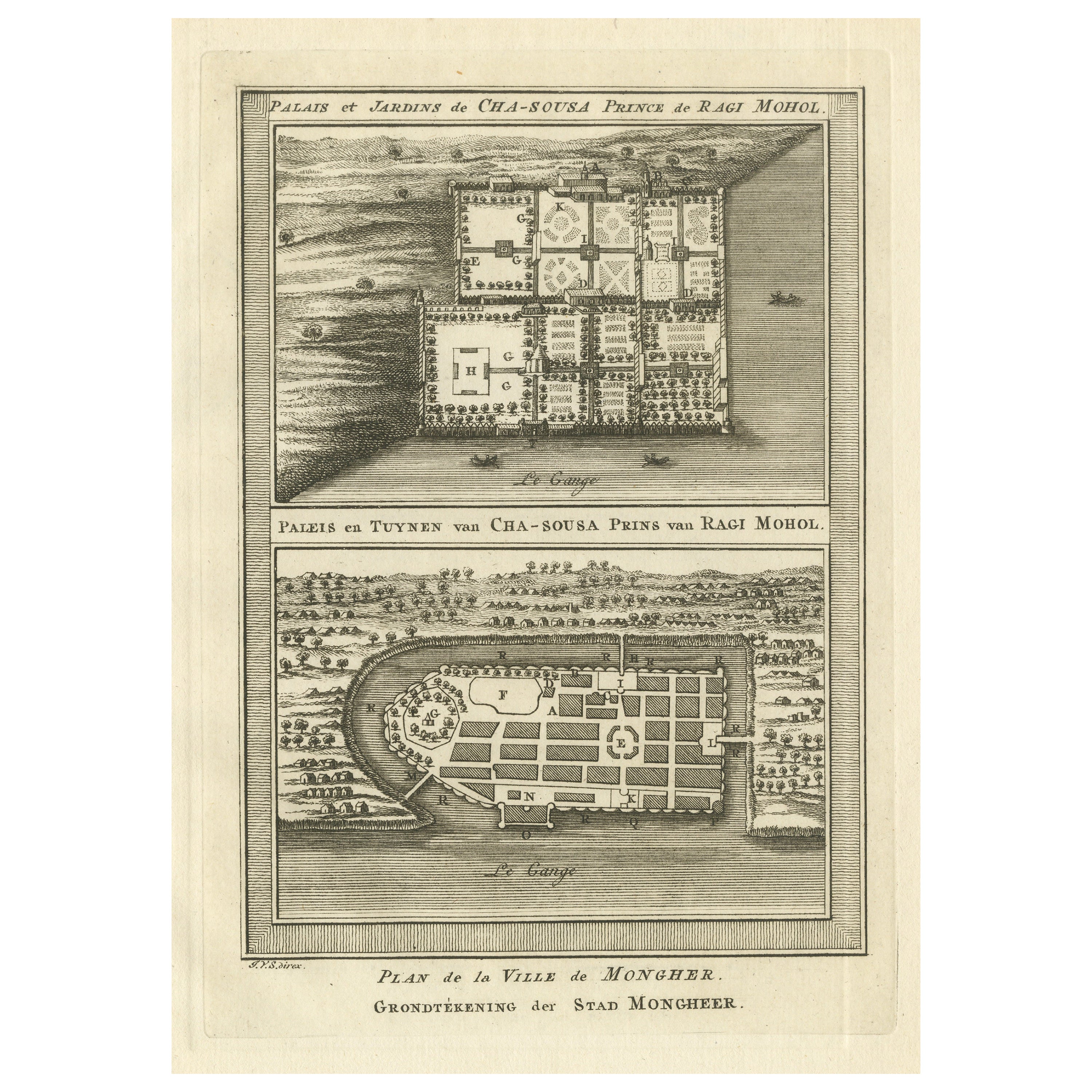
Palace & Gardens of Shah Shuja, Prince of Rajmahal & Munger, India, 1757
$229.97
$287.4620% Off
£170.42
£213.0220% Off
€192
€24020% Off
CA$313.95
CA$392.4320% Off
A$349.25
A$436.5720% Off
CHF 183.08
CHF 228.8520% Off
MX$4,267.79
MX$5,334.7420% Off
NOK 2,331.33
NOK 2,914.1720% Off
SEK 2,194.63
SEK 2,743.2920% Off
DKK 1,461.87
DKK 1,827.3420% Off
Shipping
Retrieving quote...The 1stDibs Promise:
Authenticity Guarantee,
Money-Back Guarantee,
24-Hour Cancellation
About the Item
Antique print titled 'Paleis en Tuynen van Cha-Sousa Prins van Ragi Mohol - Grondtekening der Stad Mongheer‘.
This print depicts the palace and gardens of Shah Shuja, Prince of Rajmahal. It also sjows a plan of Munger, India. Originates from a Dutch edition of 'Histoire générale des voyages' by Antoine-François Prévost.
Artists and Engravers: Engraved by J. van Schley. Jakob van der Schley (Amsterdam, 1715-1779) was a Dutch draughtsman and engraver, who studied under Bernard Picart, and whose style he subsequently copied.
- Dimensions:Height: 8.86 in (22.5 cm)Width: 6.89 in (17.5 cm)Depth: 0 in (0.02 mm)
- Materials and Techniques:
- Period:1750-1759
- Date of Manufacture:1757
- Condition:Condition: Good, general age-related toning. Blank verso, please study image carefully.
- Seller Location:Langweer, NL
- Reference Number:Seller: PCT-5157 1stDibs: LU3054327350362
About the Seller
5.0
Recognized Seller
These prestigious sellers are industry leaders and represent the highest echelon for item quality and design.
Platinum Seller
Premium sellers with a 4.7+ rating and 24-hour response times
Established in 2009
1stDibs seller since 2017
2,494 sales on 1stDibs
Typical response time: 1 hour
- ShippingRetrieving quote...Shipping from: Langweer, Netherlands
- Return Policy
Authenticity Guarantee
In the unlikely event there’s an issue with an item’s authenticity, contact us within 1 year for a full refund. DetailsMoney-Back Guarantee
If your item is not as described, is damaged in transit, or does not arrive, contact us within 7 days for a full refund. Details24-Hour Cancellation
You have a 24-hour grace period in which to reconsider your purchase, with no questions asked.Vetted Professional Sellers
Our world-class sellers must adhere to strict standards for service and quality, maintaining the integrity of our listings.Price-Match Guarantee
If you find that a seller listed the same item for a lower price elsewhere, we’ll match it.Trusted Global Delivery
Our best-in-class carrier network provides specialized shipping options worldwide, including custom delivery.More From This Seller
View AllAntique Print of the Palace and Gardens of Shah Shuja & Plan of Munger, India
Located in Langweer, NL
Antique print titled 'Paleis en Tuynen van Cha-Sousa Prins van Ragi Mohol - Grondtekening der Stad Mongheer‘. This print depicts the palace and gardens of Shah Shuja, Prince of Rajma...
Category
Antique Mid-18th Century Prints
Materials
Paper
$277 Sale Price
20% Off
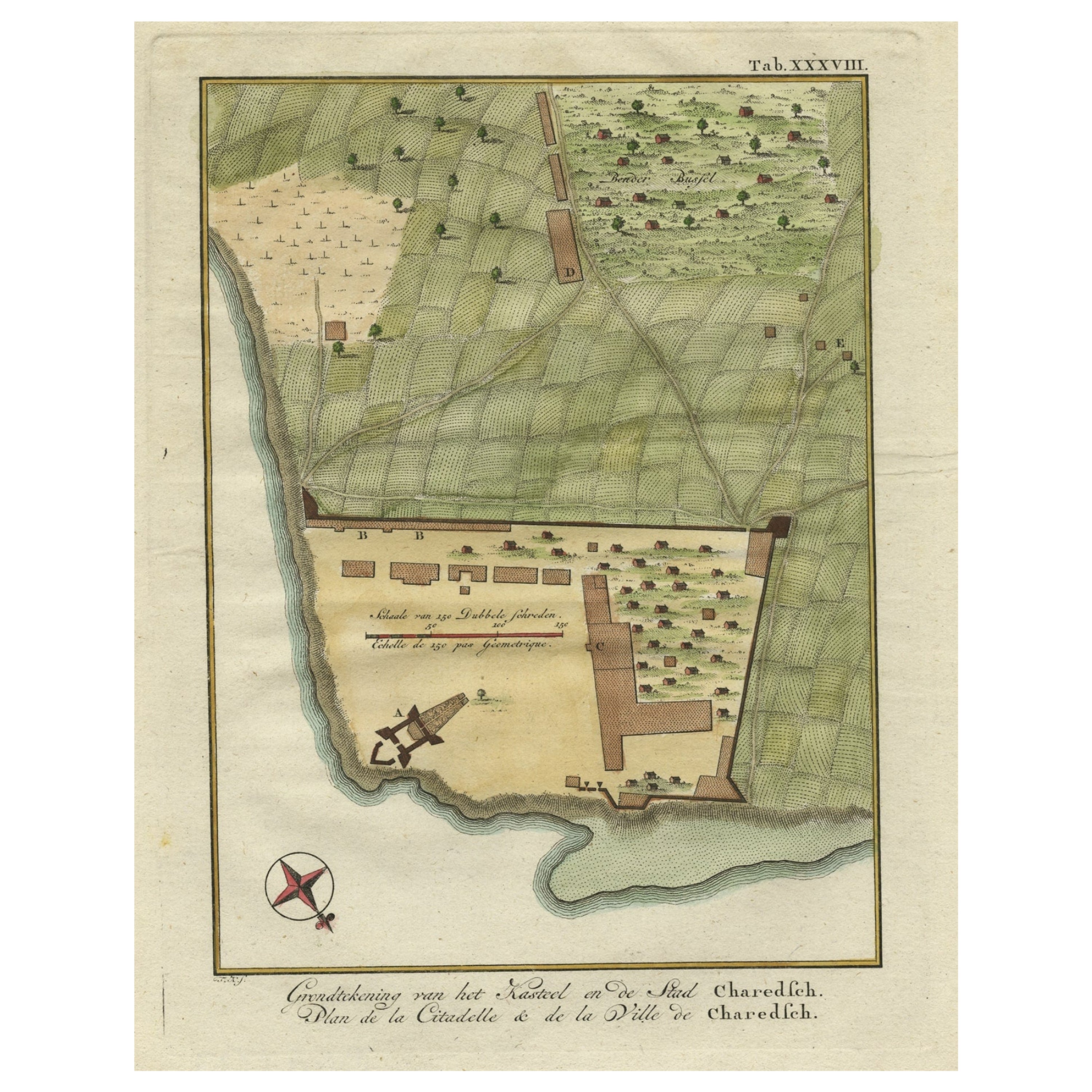
Original Antique Plan of the Fortress of Charedsch in Persia or Iran, ca.1780
Located in Langweer, NL
Antique map, titled: 'Plan de la Citadelle de la Ville de Charedsch.'
Plan of the fortress of Charedsch, Iran / Persia. This original antique print originates from 'Reize naar Ar...
Category
Antique 1780s Maps
Materials
Paper

$306 Sale Price
20% Off
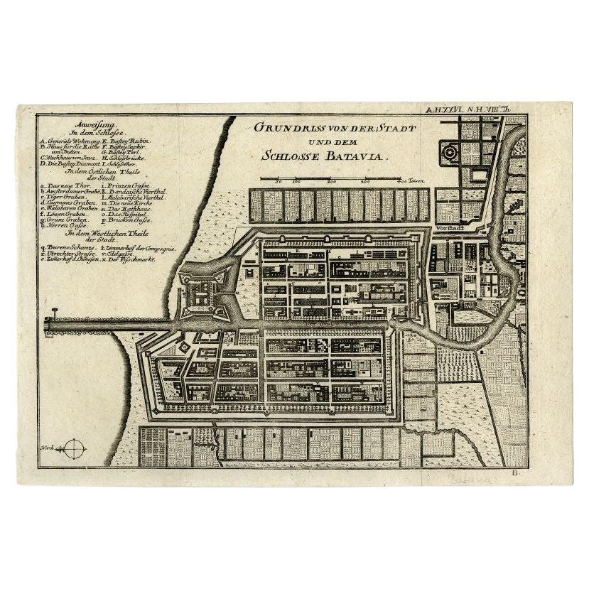
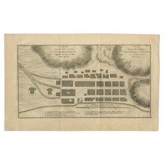
Antique Plan of Batavia and the Castle in the Dutch East Indies, 1763
Located in Langweer, NL
Antique map titled 'Grundriss von der Stadt und dem Schlosse Batavia.' Plan of the city and the castle of Batavia in the Dutch East Indies / Indonesia. From 'Algemeine Welthistorie (...
Category
Antique 18th Century Maps
Materials
Paper

$373 Sale Price
20% Off
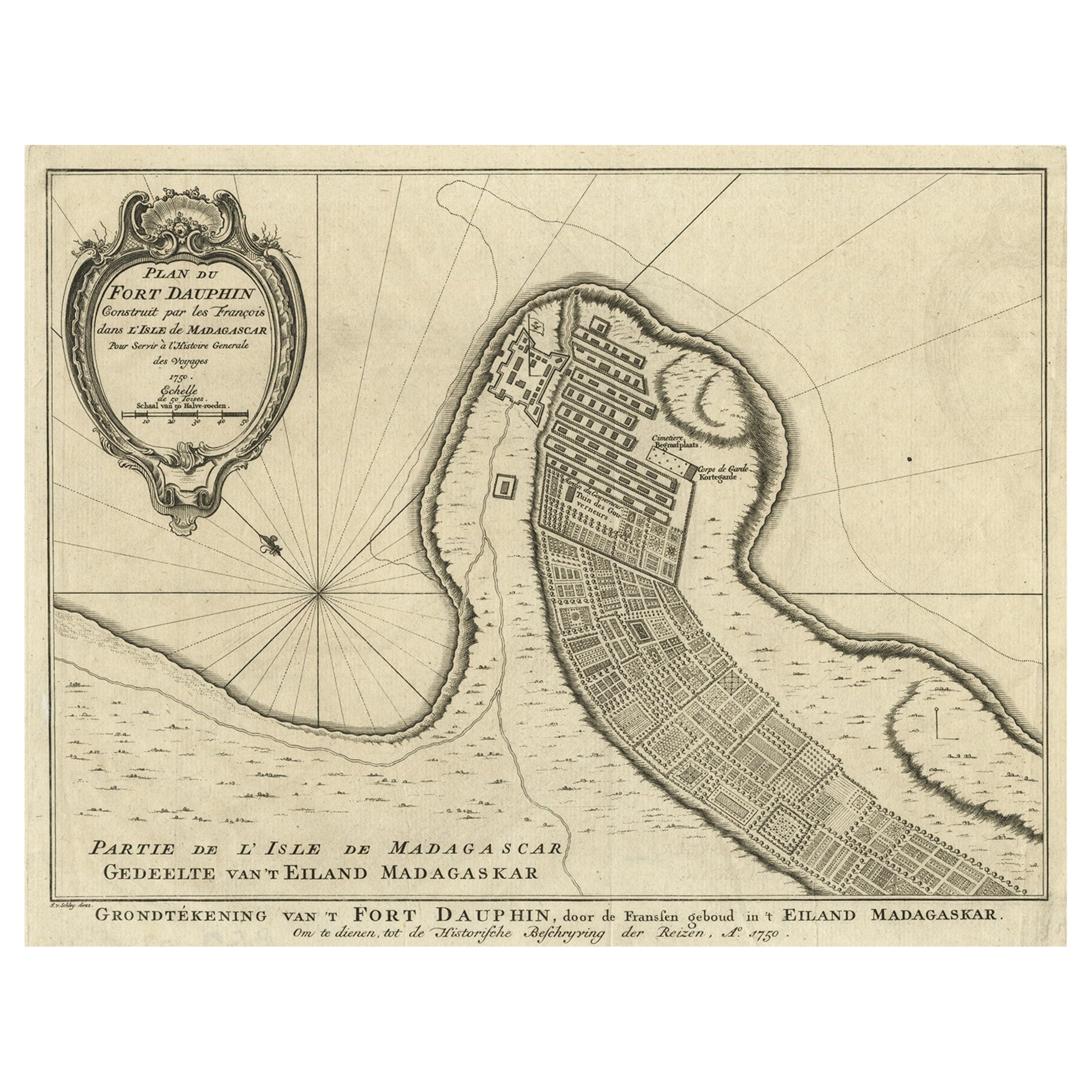
Antique Plan of Fort Dauphin on Madagascar of the East Coast of Africa, 1756
Located in Langweer, NL
Antique map titled 'Plan du Fort Dauphin (..) -
Grondtekening van 't Fort Dauphin'. Plan of Fort Dauphin on the island of Madagascar of the east coast of Africa. This print origi...
Category
Antique 1750s Maps
Materials
Paper
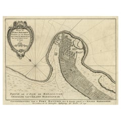
$229 Sale Price
20% Off
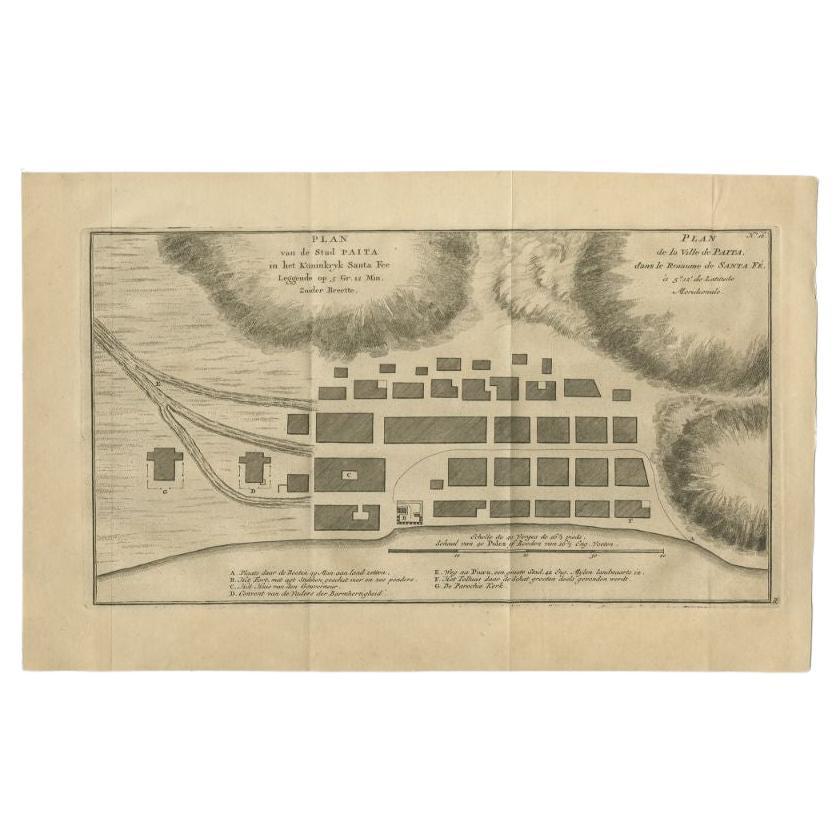
Antique Plan of the City of Paita in Peru, by Anson, 1749
Located in Langweer, NL
Antique map titled 'Plan van de Stad Paita in het Koninkryk Santa Fee (..) - Plan de la Ville de Paita (..)'. Original antique plan of the city of Paita, Peru. This map originates fr...
Category
Antique 18th Century Maps
Materials
Paper
$258 Sale Price
20% Off
Antique Bible Plan of Jerusalem by Covens & Mortier, 1743
Located in Langweer, NL
This plan originates from ‘Biblia Sacra, dat is, de H. Schriftuer van het Oude, en het Nieuwe Testament, naer de laetste Roomsche keure der gemeine Latijnsche overzettinge, in nederd...
Category
Antique Mid-18th Century Maps
Materials
Paper

$527 Sale Price
20% Off
You May Also Like
17th-18th Century Siege of Graves Mapping Engraving By Willian III
Located in Kingston, NY
RARE French 17th-18th Century Enhanced Siege of Graves Mapping Engraving BY William III, also widely known as William of Orange,
The Siege of Grave in Dutch Brabant started by Monsie...
Category
Antique 17th Century French Prints
Materials
Paper

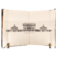
James Paine – Plans, Elevations and Section of Noblemen and Gentlemen's Houses
Located in Middletown, NY
A fine FIRST EDITION ELEPHANT FOLIO of Jame's Paine monumental work:
Plans, Elevations and Section of Noblemen and Gentlemen's Houses, and also of Stabling, Bridges, Public and Priv...
Category
Antique Mid-18th Century English Books
Materials
Leather, Paper
Antique French Map of Asia Including China Indoneseia India, 1783
Located in Amsterdam, Noord Holland
Very nice map of Asia. 1783 Dedie au Roy.
Additional information:
Country of Manufacturing: Europe
Period: 18th century Qing (1661 - 1912)
Condition: Overall Condition B (Good Used)...
Category
Antique 18th Century European Maps
Materials
Paper

$648 Sale Price
20% Off
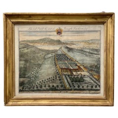
18th Century Engraving Sneed Park, the Seat of Joseph Jackson Esquire.
By Johannes Kip
Located in Vero Beach, FL
18th Century Engraving Sneed Park, the Seat of Joseph Jackson Esquire.
Hand colored engraving, “Sneed Park, the seat of Joseph Jackson Esquire. Illustration from the second volume o...
Category
Antique 18th Century English Baroque Prints
Materials
Glass, Giltwood
$1,000 Sale Price
20% Off
17th Century Topographical Map, Champagne-Ardenne, Marsal, Maubert Iohan Peeters
Located in New York, NY
Fine topographical 17th century map by Iohan Peeters of Marsal and Maubert Fontaine in the Champagne-Ardennes Region of North Eastern France.
Fabulous period engraving for a Wine Ce...
Category
Antique 17th Century Dutch Maps
Materials
Paper

Map Of India - Original Lithograph - 19th Century
Located in Roma, IT
Map of India is an original lithograph artwork realized by an Anonymous engraver of the 19th Century.
Printed in the series of "France Pittoresque".
Titled "France Pittoresque".
...
Category
19th Century Modern Figurative Prints
Materials
Lithograph

More Ways To Browse
Antique Map Of Thailand
Antique Mississippi Map
Antique Ohio Maps
Burgundy Map
John Speed Maps
Antique Map Of Turkish Empire
Antique Portuguese Scales
Canadian Atlas Furniture
Prussia Map
Afghanistan Map
Malabar Map
Antique Compass Made In France
Antique Maps Dublin
Antique Newfoundland Canada
John Speed Antique Maps
Malaysia Map
Sebastian Munster
Antique Map Chile