Items Similar to Rare Hand-Colored Antique Map of Tartary, China and Korea, ca.1741


Want more images or videos?
Request additional images or videos from the seller
1 of 5
Rare Hand-Colored Antique Map of Tartary, China and Korea, ca.1741
$2,594.48
$3,243.1020% Off
£1,942.03
£2,427.5420% Off
€2,200
€2,75020% Off
CA$3,570.74
CA$4,463.4320% Off
A$3,979.96
A$4,974.9520% Off
CHF 2,088.15
CHF 2,610.1920% Off
MX$48,601.83
MX$60,752.2920% Off
NOK 26,440.52
NOK 33,050.6420% Off
SEK 24,990.31
SEK 31,237.8920% Off
DKK 16,747.95
DKK 20,934.9420% Off
About the Item
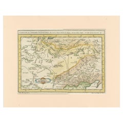
Antique map titled 'A General Map of Eastern and Western Tatary, commonly call'd Tartary; drawn from the Particular Maps of the Jesuit Missionaries'.
Rare antique map of Tartary, China and Korea. Includes a nice detail of Korea, Japan and China, along with a detailed chart explaining the subdivisions within Tartary. The map was engraved by Emanuel Bowen and originates from an English Edition of Du Halde's Descriptions De La Chine.
Artists and Engravers: Emanuel Bowen (1694?–1767) was an English map engraver, who worked for George II of England and Louis XV of France as a geographer.
- Dimensions:Height: 16.15 in (41 cm)Width: 21.66 in (55 cm)Depth: 0 in (0.02 mm)
- Materials and Techniques:
- Period:1740-1749
- Date of Manufacture:circa 1741
- Condition:Wear consistent with age and use. Condition: Good, general age-related toning. Minor defects from handling, please study image carefully.
- Seller Location:Langweer, NL
- Reference Number:Seller: BG-00746 1stDibs: LU3054326762402
About the Seller
5.0
Recognized Seller
These prestigious sellers are industry leaders and represent the highest echelon for item quality and design.
Platinum Seller
Premium sellers with a 4.7+ rating and 24-hour response times
Established in 2009
1stDibs seller since 2017
2,513 sales on 1stDibs
Typical response time: <1 hour
- ShippingRetrieving quote...Shipping from: Langweer, Netherlands
- Return Policy
Authenticity Guarantee
In the unlikely event there’s an issue with an item’s authenticity, contact us within 1 year for a full refund. DetailsMoney-Back Guarantee
If your item is not as described, is damaged in transit, or does not arrive, contact us within 7 days for a full refund. Details24-Hour Cancellation
You have a 24-hour grace period in which to reconsider your purchase, with no questions asked.Vetted Professional Sellers
Our world-class sellers must adhere to strict standards for service and quality, maintaining the integrity of our listings.Price-Match Guarantee
If you find that a seller listed the same item for a lower price elsewhere, we’ll match it.Trusted Global Delivery
Our best-in-class carrier network provides specialized shipping options worldwide, including custom delivery.More From This Seller
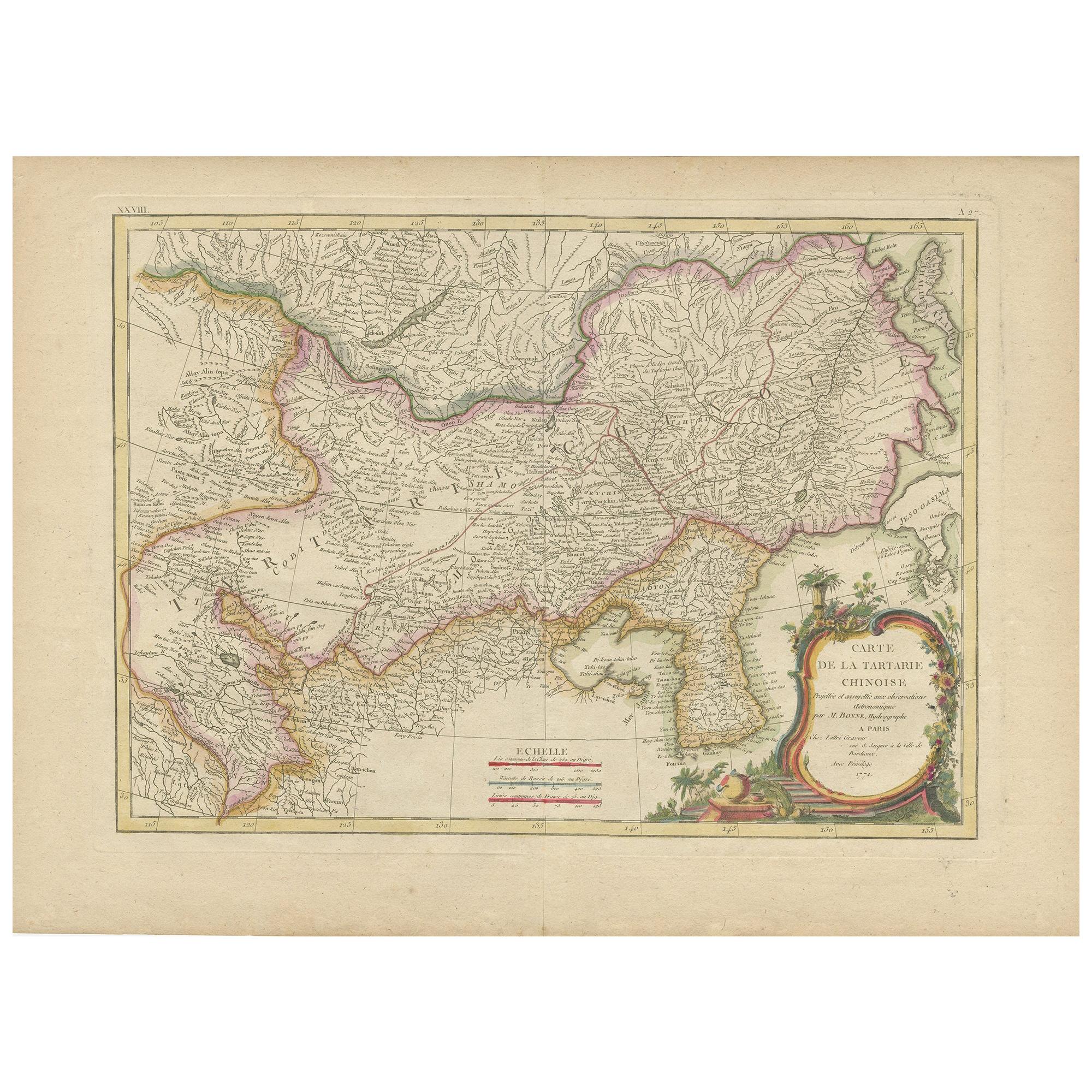
View AllAntique Map of Korea and Southern China by Bonne '1771'
Located in Langweer, NL
Antique map titled 'Carte de la Tartarie Chinoise'. Original antique map of Korea and Southern China. Covers from the Lop Nor region eastward to K...
Category
Antique Mid-18th Century Maps
Materials
Paper
$542 Sale Price
20% Off
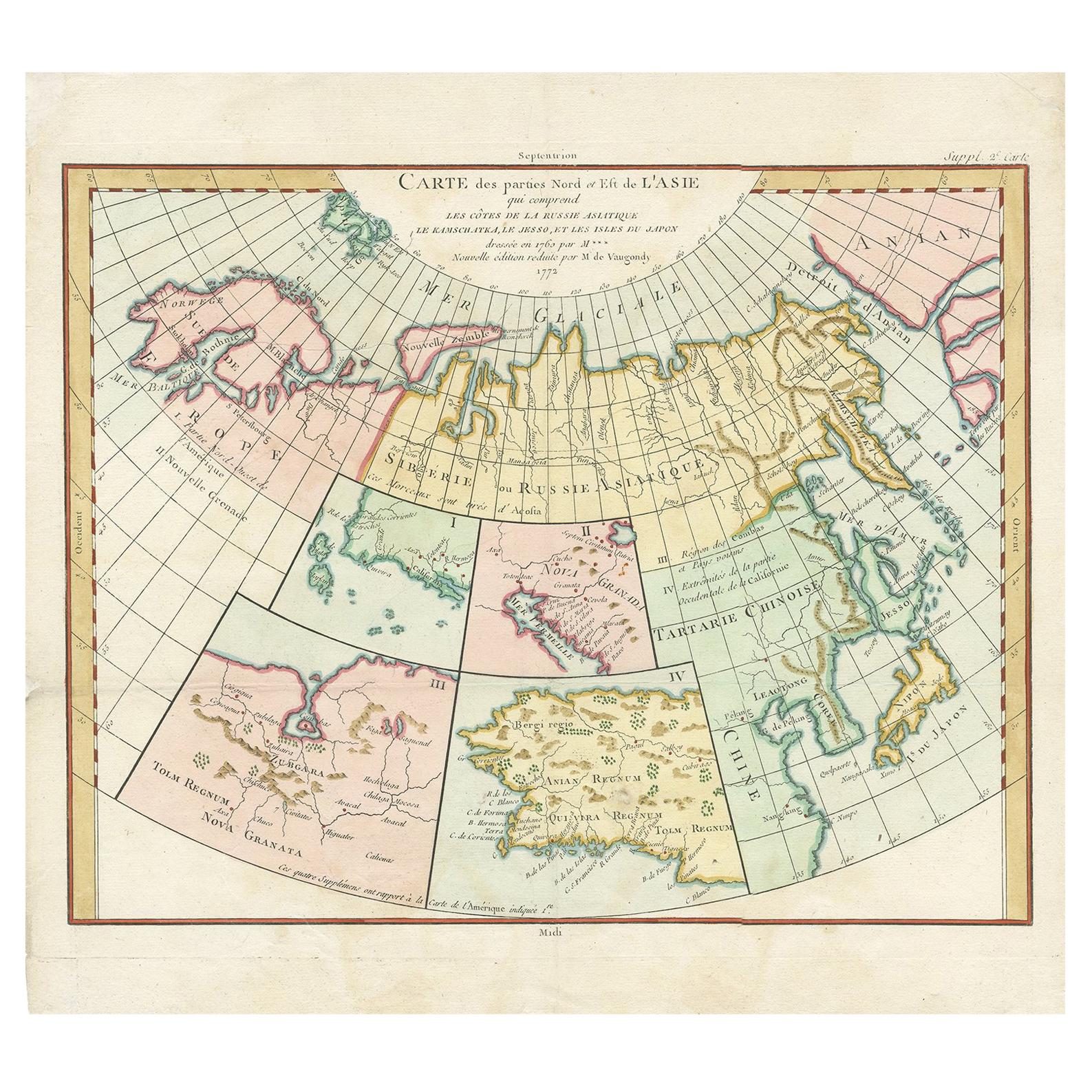
Antique Map of North and East Asia, 1751
Located in Langweer, NL
Map 2: 'Carte des parties nord et est de L'Asie'. (Map of the Northern parts and East Asia.) Five maps on one sheet, showing California, Alaska and Siberia, Korea and Japan. South to...
Category
Antique 18th Century Maps
Materials
Paper

Antique Map of China, Korea, Japan and the Northern Philippines, circa 1780
Located in Langweer, NL
Antique map titled 'Carte de l'Empire de la Chine de la Tartarie Chinoise, et du Royaume de Corée'. Interesting and detailed map of China, Korea, Japan and the Northern Philippines. ...
Category
Antique Late 18th Century Maps
Materials
Paper

$283 Sale Price
20% Off
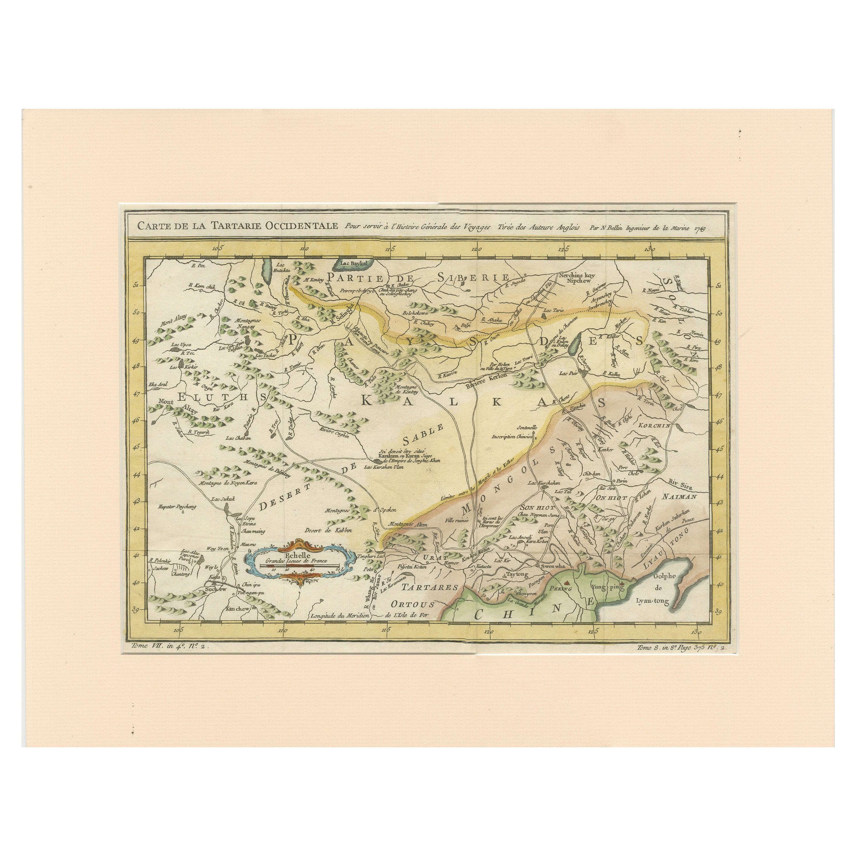
Antique Map of Tartary and Northeast Asia with Hand Coloring
Located in Langweer, NL
Antique map titled 'Carte de la Tartarie Occidentale'. An interesting map of Tartary and northeast Asia, from Lake Baykal, Partie du Siberia in the north, Pays des Kalkas at the cent...
Category
Antique Mid-18th Century Maps
Materials
Paper
$264 Sale Price
20% Off
Antique Map of North Europe and East Asia by Vaugondy, circa 1750
Located in Langweer, NL
Antique map titled 'Carte des parties nord et est de L'Asie'. Map of the Northern parts and East Asia. Five maps on one sheet, showing California, Alaska and Syberia, Korea and Japan...
Category
Antique Mid-18th Century Maps

Antique Map of Tartary and Northeast Asia by Bellin, circa 1750
By Jacques-Nicolas Bellin
Located in Langweer, NL
Antique map titled 'Carte de la Tartarie Occidentale'. Map of Tartary and northeast Asia, from Lake Baykal, Partie du Siberia in the north, Pays des Kalkas at the center, as well as ...
Category
Antique Mid-18th Century European Maps
Materials
Paper

$132 Sale Price
20% Off
You May Also Like
Super Rare Antique French Map of Chine and the Chinese Empire, 1780
Located in Amsterdam, Noord Holland
Super Rare Antique French Map of Chine and the Chinese Empire, 1780
Very nice map of Asia. 1780 Made by Bonne.
Additional information:
Type: Map
...
Category
Antique 18th Century European Maps
Materials
Paper

$584 Sale Price
32% Off
California, Alaska and Mexico: 18th Century Hand-Colored Map by de Vaugondy
By Didier Robert de Vaugondy
Located in Alamo, CA
This is an 18th century hand-colored map of the western portions of North America entitled "Carte de la Californie et des Pays Nord-Ouest separés de l'Asie par le détroit d'Anian, ex...
Category
Antique 1770s French Maps
Materials
Paper

Early 19th Century Hand Coloured Map of North America by Aaron Arrowsmith
By Aaron Arrowsmith
Located in Hamilton, Ontario
Hand coloured map in French by English cartographer Aaron Arrowsmith (1750–1823) titled "Amerique Septentionale" (North America).
Map size: 9.5" x 8"
Mat size: 20.5" x 14.25".
Category
Antique Early 19th Century English Maps
Materials
Paper

$795 Sale Price
36% Off
English Engraved Hand Colored Map of the North Eastern United States, circa 1817
Located in Charleston, SC
English copper engraved hand colored map of the North Eastern United States matted under glass in a gilt frame, Early 19th Century. Drawn and Engraved for Thomson's New General Atlas...
Category
Antique 1810s English George III Maps
Materials
Glass, Giltwood, Paint, Paper

Antique French Map of Asia Including China Indoneseia India, 1783
Located in Amsterdam, Noord Holland
Very nice map of Asia. 1783 Dedie au Roy.
Additional information:
Country of Manufacturing: Europe
Period: 18th century Qing (1661 - 1912)
Condition: Overall Condition B (Good Used)...
Category
Antique 18th Century European Maps
Materials
Paper

$648 Sale Price
20% Off
Hand-Colored 18th Century Homann Map of the Black Sea, Turkey and Asia Minor
By Johann Baptist Homann
Located in Alamo, CA
An attractive original early 18th century hand-colored map of the Black Sea and Turkey entitled "Carte de L'Asie Minevre ou de la Natolie et du Pont Evxin Tiree des Voyages et des Ob...
Category
Antique Early 18th Century German Maps
Materials
Paper

More Ways To Browse
Antique Map Of Korea
Thailand Map
Antique Maps Of Russian Empire
Antique Navigational Tools
Australian Colonial
Antique German Compass
Key Trade Sign
Spanish Galleon
World Map Of Trade Routes
Antique Puerto Rico
Albanian Antique
Antique Furniture Wiltshire
Antique Maps Of Israel
Framed Africa Maps
Antique Furniture Goa
Croatian Antiques
Map Of Israel
Teak Sphere