Items Similar to Antique Map of Ancient Persia, Assyria and surroundings, c.1760


Want more images or videos?
Request additional images or videos from the seller
1 of 5
Antique Map of Ancient Persia, Assyria and surroundings, c.1760
$325.79
$407.2320% Off
£241.42
£301.7820% Off
€272
€34020% Off
CA$444.76
CA$555.9520% Off
A$494.78
A$618.4720% Off
CHF 259.37
CHF 324.2120% Off
MX$6,046.04
MX$7,557.5520% Off
NOK 3,302.72
NOK 4,128.4120% Off
SEK 3,109.06
SEK 3,886.3220% Off
DKK 2,070.98
DKK 2,588.7320% Off
Shipping
Retrieving quote...The 1stDibs Promise:
Authenticity Guarantee,
Money-Back Guarantee,
24-Hour Cancellation
About the Item
Antique map titled 'De XII de Landkaart vertoonende de Landen der Assyrische, Babylonische, Persische, Grieksche en daarna Romeinsche Heerschappy.' Map of ancient Persia, Assyria etc. Source unknown, to be determined.
Artists and Engravers: Made by 'Willem Albert Bachiene' after an anonymous artist. Willem Albert Bachiene (Leerdam 1712 - Maastricht 1783). He was a Clergyman in the army and in Namen, Belgium and Kuilenburg (Culemborg). From 1759 he was Clergyman in Maastricht and also Professor in Astronomy and Geography at the 'Illustere School'.
Condition: Good, given age. A few small spots. Original folds as issued. General age-related toning and/or occasional minor defects from handling. Please study image carefully.
Date: c.1760
Overall size: 26 x 37.8 cm.
Image size: 23.4 x 33 cm.
We sell original antique maps to collectors, historians, educators and interior decorators all over the world. Our collection includes a wide range of authentic antique maps from the 16th to the 20th centuries. Buying and collecting antique maps is a tradition that goes back hundreds of years. Antique maps have proved a richly rewarding investment over the past decade, thanks to a growing appreciation of their unique historical appeal. Today the decorative qualities of antique maps are widely recognized by interior designers who appreciate their beauty and design flexibility. Depending on the individual map, presentation, and context, a rare or antique map can be modern, traditional, abstract, figurative, serious or whimsical. We offer a wide range of authentic antique maps for any budget.
- Dimensions:Height: 14.89 in (37.8 cm)Width: 10.24 in (26 cm)Depth: 0 in (0.01 mm)
- Materials and Techniques:
- Period:
- Date of Manufacture:circa 1760
- Condition:
- Seller Location:Langweer, NL
- Reference Number:Seller: PCT-620281stDibs: LU3054326077322
About the Seller
5.0
Recognized Seller
These prestigious sellers are industry leaders and represent the highest echelon for item quality and design.
Platinum Seller
Premium sellers with a 4.7+ rating and 24-hour response times
Established in 2009
1stDibs seller since 2017
2,494 sales on 1stDibs
Typical response time: 1 hour
- ShippingRetrieving quote...Shipping from: Langweer, Netherlands
- Return Policy
Authenticity Guarantee
In the unlikely event there’s an issue with an item’s authenticity, contact us within 1 year for a full refund. DetailsMoney-Back Guarantee
If your item is not as described, is damaged in transit, or does not arrive, contact us within 7 days for a full refund. Details24-Hour Cancellation
You have a 24-hour grace period in which to reconsider your purchase, with no questions asked.Vetted Professional Sellers
Our world-class sellers must adhere to strict standards for service and quality, maintaining the integrity of our listings.Price-Match Guarantee
If you find that a seller listed the same item for a lower price elsewhere, we’ll match it.Trusted Global Delivery
Our best-in-class carrier network provides specialized shipping options worldwide, including custom delivery.More From This Seller
View AllAntique Map of Persia by A. Zatta, circa 1785
Located in Langweer, NL
Antique map titled 'L'Impero della Persia diviso ne suoi Stati'. The Empire of Persia divided into its states. Originates from 'Atlante Novissimo, illustrato ed accresciuto sulle oss...
Category
Antique Late 18th Century Maps
Materials
Paper

$335 Sale Price
20% Off
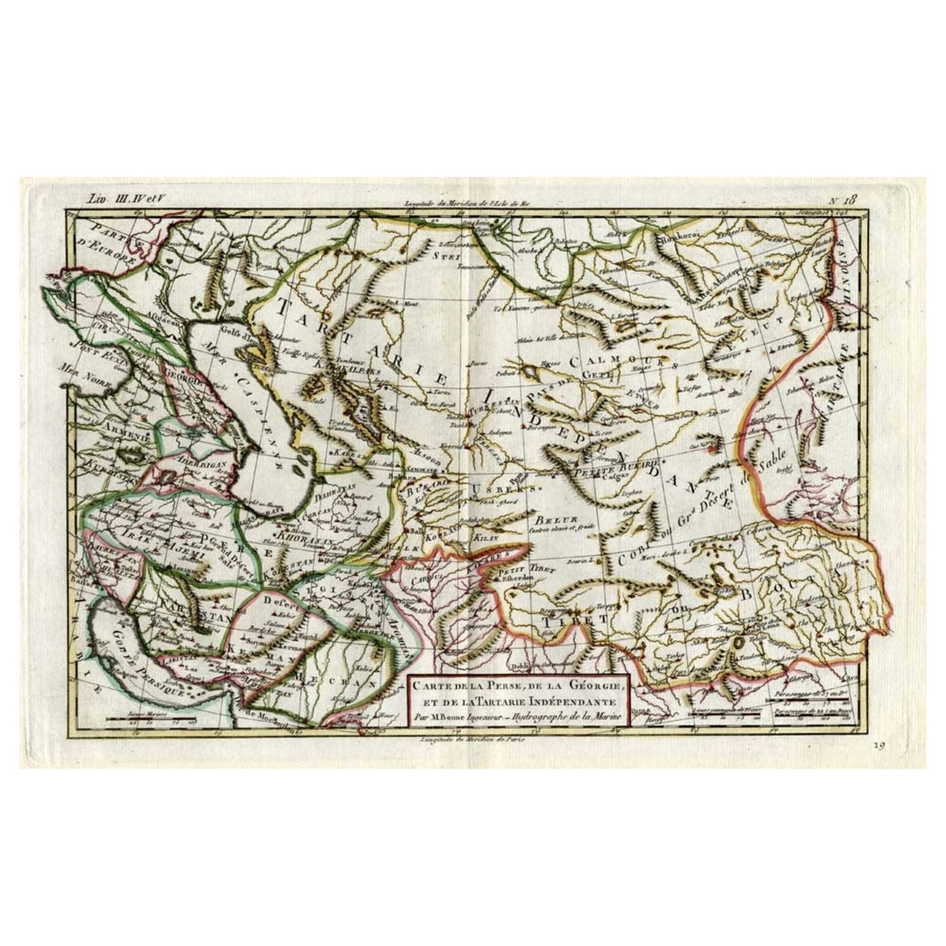
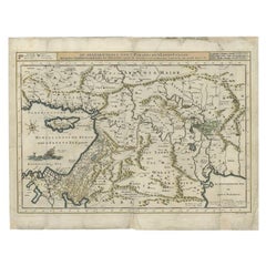
Antique Map of the Persian Gulf and Caspian Sea Region by R. Bonne, 1780
Located in Langweer, NL
Antique print titled 'Carte de la Perse, de la Georgie, et de la Tartarie Independante'. Shows the region from the Persian Gulf and Caspian Sea in the wes...
Category
Antique Late 18th Century French Maps
Materials
Paper

Antique Map of the Middle East by Mortier, 1700
Located in Langweer, NL
Antique map titled 'Carte de la Situation du Paradis Terrestre (..)'. Detailed map of the Holy Land and the Middle East, centered on the Garden of Eden and including a large Cyprus. ...
Category
Antique 18th Century Maps
Materials
Paper

$229 Sale Price
20% Off
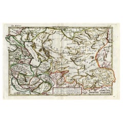
Antique Map of Persia, Georgia and Kazakhstan, ca.1780
Located in Langweer, NL
Antique map titled 'Carte de la Perse, de la Georgie, et de la Tartarie Independante'.
Map of Persia, Georgia and Kazakhstan. This map shows current days Georgia, Iran, Irak, Kaz...
Category
Antique 1780s Maps
Materials
Paper
$498 Sale Price
20% Off
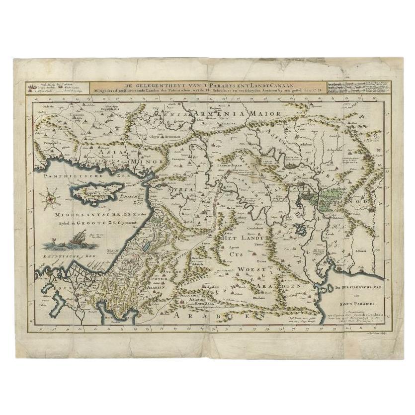
Antique Map of the Mediterranean and the Persian Gulf by Danckerts, c.1718
Located in Langweer, NL
Antique map titled 'De Gelegentheyt Van't Paradys en 't Landt Canaan.' Dutch Bible map covering the region between the Mediterranean and the Persian Gulf, f...
Category
Antique 18th Century Maps
Materials
Paper
$392 Sale Price
20% Off
Original Antique Map of Syria Phoenice by Van Dùren '1749'
Located in Langweer, NL
Interesting Antique map published in Germany titled 'Neue Vorstellung von Phoenice und Syrien (..)' This map is engraved with a lot of details. It is an original antique map of Syria...
Category
Antique Mid-18th Century Maps
Materials
Paper

$287 Sale Price
20% Off
You May Also Like
Original Antique Map of Ancient Greece, Achaia, Corinth, 1786
Located in St Annes, Lancashire
Great map of Ancient Greece. Showing the region of Thessaly, including Mount Olympus
Drawn by J.D. Barbie Du Bocage
Copper plate engraving by P.F Tardieu
Original hand color...
Category
Antique 1780s French Other Maps
Materials
Paper

Original Antique Map of Ancient Greece- Boeotia, Thebes, 1787
Located in St Annes, Lancashire
Great map of Ancient Greece. Showing the region of Boeotia, including Thebes
Drawn by J.D. Barbie Du Bocage
Copper plate engraving by P.F T...
Category
Antique 1780s French Other Maps
Materials
Paper

Antique French Map of Asia Including China Indoneseia India, 1783
Located in Amsterdam, Noord Holland
Very nice map of Asia. 1783 Dedie au Roy.
Additional information:
Country of Manufacturing: Europe
Period: 18th century Qing (1661 - 1912)
Condition: Overall Condition B (Good Used)...
Category
Antique 18th Century European Maps
Materials
Paper

$648 Sale Price
20% Off
1627 Hendrik Hondius Map Entitled "Vltoniae Orientalis Pars, " Ric.a009
Located in Norton, MA
1627 Hendrik Hondius map entitled
"Vltoniae orientalis pars,"
Ric.a009
Title:
Vltoniae orientalis : pars
Title (alt.) :
Ultoniae orientalis pars
Creator:
Mercator, Gerh...
Category
Antique 17th Century Dutch Maps
Materials
Paper

Persia, Armenia & Adjacent Regions: A 17th Century Hand-colored Map by De Wit
By Frederick de Wit
Located in Alamo, CA
A large 17th century hand colored copperplate engraved map entitled "Novissima nec non Perfectissima Scandinaviae Tabula comprehendens Regnorum Sueciae, Daniae et Norvegiae distincte...
Category
Antique Late 17th Century Dutch Maps
Materials
Paper

Southern Greece: A Large 17th C. Hand-colored Map by Sanson and Jaillot
By Nicolas Sanson
Located in Alamo, CA
This large original hand-colored copperplate engraved map of southern Greece and the Pelopponese Peninsula entitled "La Moree Et Les Isles De Zante, Cefalonie, Ste. Marie, Cerigo & C...
Category
Antique 1690s French Maps
Materials
Paper

More Ways To Browse
Antique Maps Persia
Antique Navigator
Map Of Middle East
Antique Map Of Switzerland
World Map Copper
British Empire Map
Malaysian Antique Furniture
Birds Eye View Map
Map Of Arabia
Map Of Vienna
Old School Maps
Balinese Wood
Joan Blaeu
Antique Nautical Maps
Antique Portuguese Plates
Antique Maps California
New Zealand Map
Antique Railroad Collectibles