Items Similar to Antique Map of the City of Rio de Janeiro by Balbi '1847'


Want more images or videos?
Request additional images or videos from the seller
1 of 5
Antique Map of the City of Rio de Janeiro by Balbi '1847'
$283.48
£212.99
€240
CA$390.36
A$436.88
CHF 228.69
MX$5,307.32
NOK 2,903.81
SEK 2,740.24
DKK 1,826.64
About the Item
Antique map titled 'Rio de Janeiro'. Original antique map of the city of Rio de Janeiro, Brazil. This map originates from 'Abrégé de Géographie (..)' by Adrien Balbi. Published 1847.
- Dimensions:Height: 9.06 in (23 cm)Width: 11.23 in (28.5 cm)Depth: 0.02 in (0.5 mm)
- Materials and Techniques:
- Period:
- Date of Manufacture:1847
- Condition:General age-related toning, original folding line. Minor wear, blank verso. Please study image carefully.
- Seller Location:Langweer, NL
- Reference Number:Seller: BG-12783-91stDibs: LU3054324649122
About the Seller
5.0
Recognized Seller
These prestigious sellers are industry leaders and represent the highest echelon for item quality and design.
Platinum Seller
Premium sellers with a 4.7+ rating and 24-hour response times
Established in 2009
1stDibs seller since 2017
2,534 sales on 1stDibs
Typical response time: <1 hour
- ShippingRetrieving quote...Shipping from: Langweer, Netherlands
- Return Policy
Authenticity Guarantee
In the unlikely event there’s an issue with an item’s authenticity, contact us within 1 year for a full refund. DetailsMoney-Back Guarantee
If your item is not as described, is damaged in transit, or does not arrive, contact us within 7 days for a full refund. Details24-Hour Cancellation
You have a 24-hour grace period in which to reconsider your purchase, with no questions asked.Vetted Professional Sellers
Our world-class sellers must adhere to strict standards for service and quality, maintaining the integrity of our listings.Price-Match Guarantee
If you find that a seller listed the same item for a lower price elsewhere, we’ll match it.Trusted Global Delivery
Our best-in-class carrier network provides specialized shipping options worldwide, including custom delivery.More From This Seller
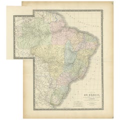
View AllAntique Map of Brazil by Wyld, '1845'
Located in Langweer, NL
Antique map titled 'Empire of Brazil'. Original antique map of Brazil. This map originates from 'An Atlas of the World, Comprehending Separate Ma...
Category
Antique Mid-19th Century Maps
Materials
Paper

$236 Sale Price
20% Off
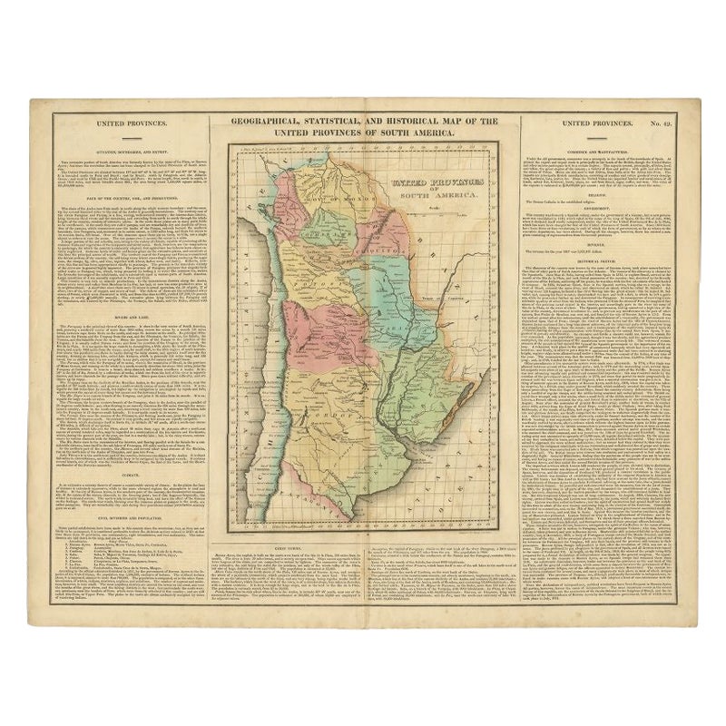
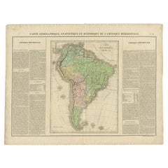
Antique Map of South America by Finlayson, 1822
Located in Langweer, NL
Antique map titled 'Geographical, Statistical and Historical Map of the United Provinces of South America'. This map depicts part of South America (including part of Brazil and Chili...
Category
Antique 19th Century Maps
Materials
Paper
$253 Sale Price
20% Off
Antique Map of the Northern Part of South America by J. Tallis, circa 1851
Located in Langweer, NL
A decorative and detailed mid-19th century map of the northern part of South America (including modern day Venezuela, Colombia, Ecuador, Guyana, Suriname and French Guiana) which was drawn and engraved by J. Rapkin (vignettes by H. Winkles & W. Lacey) and published in John Tallis & Co.'s The Illustrated Atlas (London & New York: circa 1851).
The Illustrated Atlas, published from 1849 onwards, was the last decorative world atlas. The 'Venezuela, New Granada...' map was typical of the many Fine ones which appeared in this work with its decorative border and attractive vignettes. Illustrated are views of Mount Chimborazo, Ecuador; the 'Fall of the Bagota' (Tequendama Falls, Colombia); Rheas and a prospect of Paramaribo Harbour (Dutch Guiana...
Category
Antique Mid-19th Century Maps
Materials
Paper

$259 Sale Price
20% Off
Antique Map of Brazil by Levasseur '1875'
Located in Langweer, NL
Antique map titled 'Carte du Brésil'. Large map of Brazil, with small fold out. This map originates from 'Atlas de Géographie Moderne Physique et Politiq...
Category
Antique Late 19th Century Maps
Materials
Paper
$377 Sale Price
20% Off
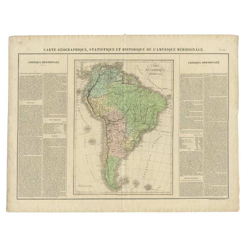
Antique Map of South America by Buchon, 1825
Located in Langweer, NL
Antique map titled 'Carte de l'Amérique méridionale'. Map of South America with attractive topography, surrounded on three sides by text on the history, geography, and economy of the...
Category
Antique 19th Century Maps
Materials
Paper
$129 Sale Price
20% Off
Antique Map of Southern Brazil and Uruguay by Bonne, c.1780
Located in Langweer, NL
"Antique map titled 'Carte de la Partie Meridional du Bresil avec les Possessions Espagnoles Voisines Qui en Sont a l'Ouest.' Map of southern Brazil and present-day Uruguay from Port...
Category
Antique 18th Century Maps
Materials
Paper
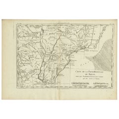
$132 Sale Price
20% Off
You May Also Like
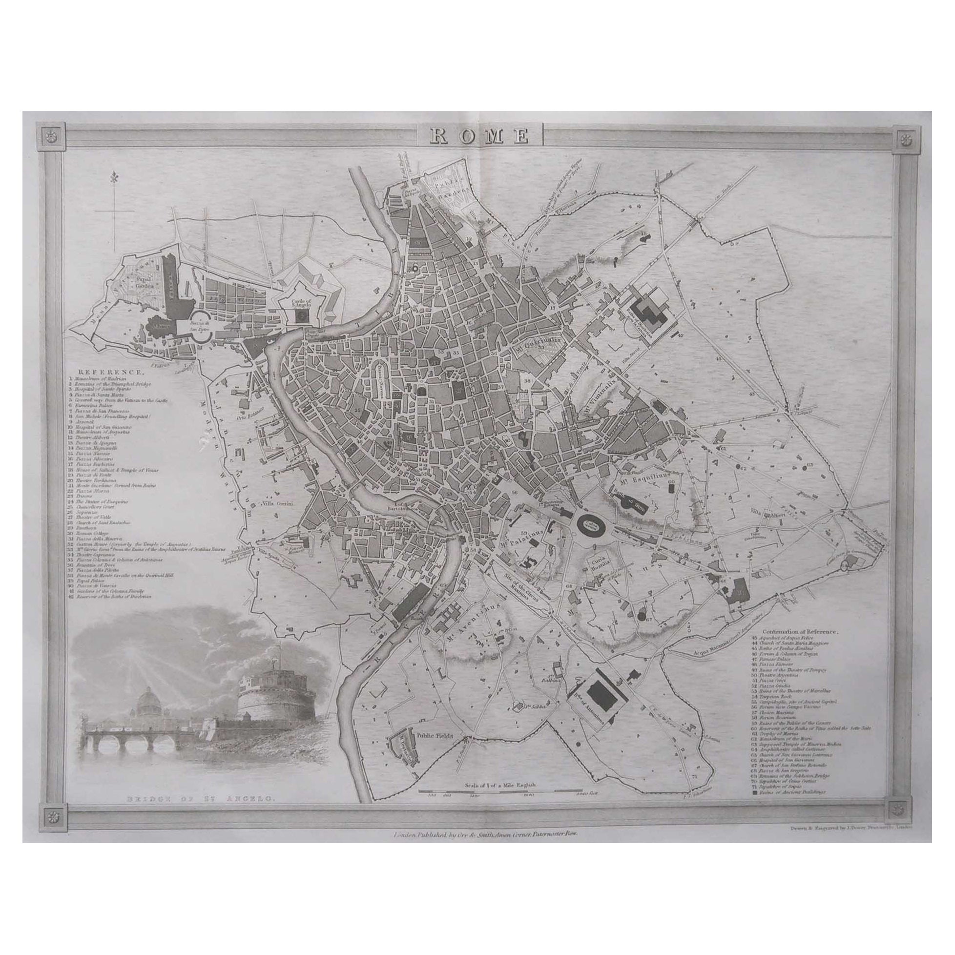
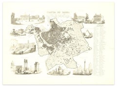
Original Antique Map or City Plan of Rome, Italy. Circa 1835
Located in St Annes, Lancashire
Nice map of Rome
Drawn and engraved by J.Dower
Published by Orr & Smith. C.1835
Unframed.
Free shipping
Category
Antique 1830s English Maps
Materials
Paper

Original Antique Map or City Plan of Madrid, Spain. Circa 1835
Located in St Annes, Lancashire
Nice map of Madrid
Drawn and engraved by J.Dower
Published by Orr & Smith. C.1835
Unframed.
Free shipping
Category
Antique 1830s English Maps
Materials
Paper

Original Antique Map or City Plan of Geneva, Switzerland. Circa 1835
Located in St Annes, Lancashire
Nice map of Geneva
Drawn and engraved by J.Dower
Published by Orr & Smith. C.1835
Unframed.
Free shipping
Category
Antique 1830s English Maps
Materials
Paper

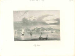
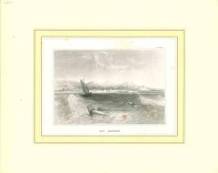
Ancient View of Rio Janeiro - Original Lithograph - Early 19th Century
Located in Roma, IT
Ancient View of Rio Janeiro is an original modern artwork realized in the first half of the 19th Century.
Original Lithograph on Ivory Paper.
Inscripted on the lower margin: Rio J...
Category
Early 19th Century Modern Figurative Prints
Materials
Lithograph
Map of Ancient Rome - Original Etching by Alessandro Moschetti - 1848
By Alessandro Moschetti
Located in Roma, IT
Plan of Rome is a beautiful original black and white etching, a rare and antique illustrated map of the eternal city of Rome, published in 1848.
Image Di...
Category
1840s Figurative Prints
Materials
Etching
Ancient View of Rio Janeiro - Original Lithograph - Early 19th Century
Located in Roma, IT
Ancient View of Rio Janeiro is an original modern artwork realized in the first half of the 19th Century.
Original Lithograph on Ivory Paper.
Inscripted in capital letters on the ...
Category
Early 19th Century Modern Figurative Prints
Materials
Lithograph
More Ways To Browse
Antique Map Of The South Of France
Antique Maps Of Greece
Large Framed Maps
Java Map
Antique Marine Maps
Antique Indian Maps
West Africa Map
Antique Maps Of Wales
Antique Map Denmark
Antique Mining
Antique World Globe Map
Antique Oregon
Hemispheres Map
Map New Holland
Treasure Map
Caribbean Antiques
19th Century Map Of Africa
Antique Malaysia