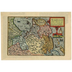
Items Similar to Antique Map of Friesland, Groningen and German East Friesland by Ortelius, 1603

Want more images or videos?
Request additional images or videos from the seller
1 of 5
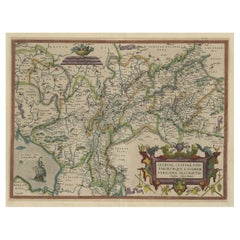
Antique Map of Friesland, Groningen and German East Friesland by Ortelius, 1603
$306.62
$778.5360% Off
£227.22
£576.9360% Off
€256
€65060% Off
CA$418.60
CA$1,062.8460% Off
A$465.67
A$1,182.3760% Off
CHF 244.11
CHF 619.8160% Off
MX$5,690.39
MX$14,448.2660% Off
NOK 3,108.45
NOK 7,892.5460% Off
SEK 2,926.17
SEK 7,429.7360% Off
DKK 1,949.16
DKK 4,949.0460% Off
Shipping
Retrieving quote...The 1stDibs Promise:
Authenticity Guarantee,
Money-Back Guarantee,
24-Hour Cancellation
About the Item
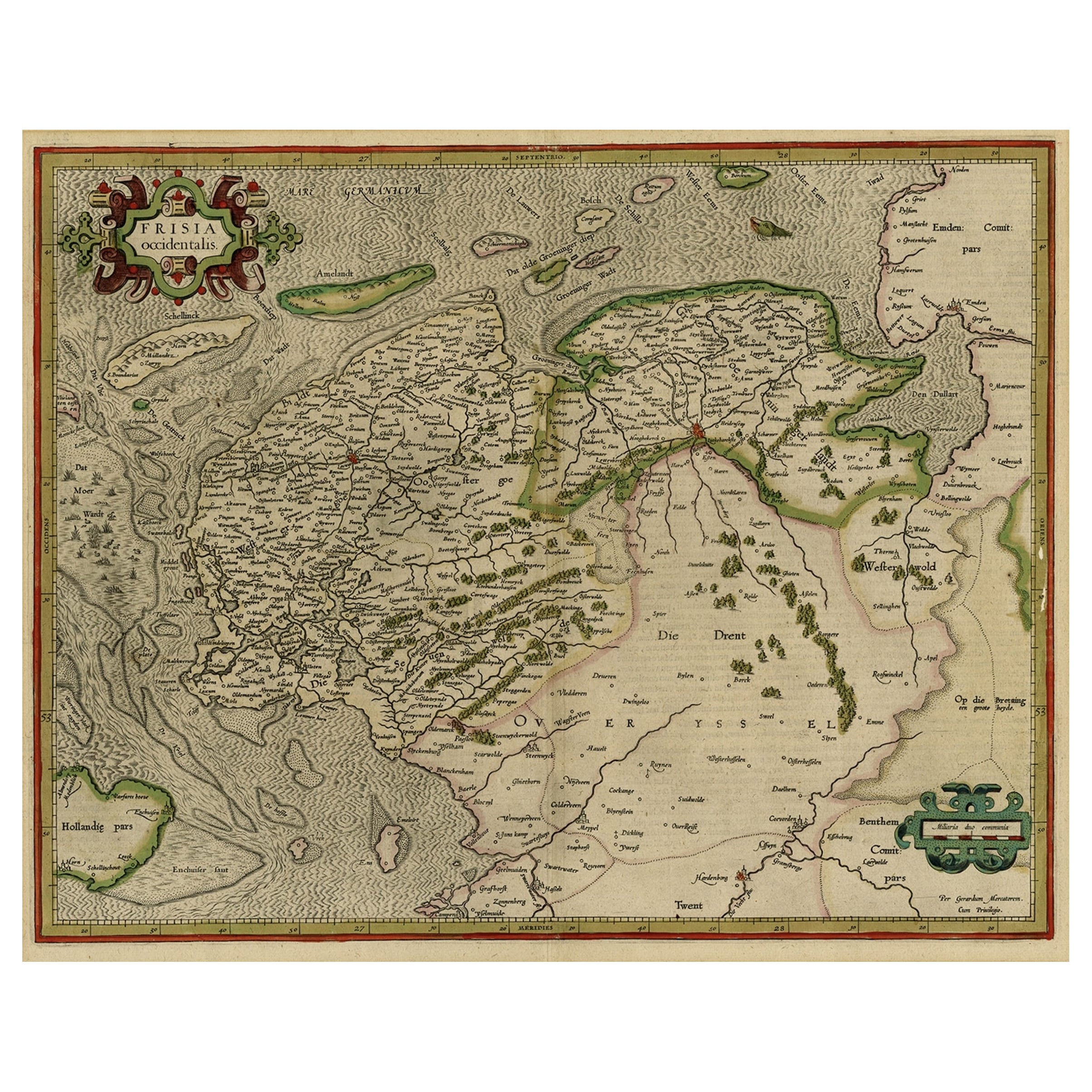
Antique map titled 'Oost end West Vrieslandts beschrijvinghe. Utriusque Frisiorum Regionis Noviss: Descriptio. 1568.' Detailed map of Friesland, the Netherlands. Includes a larger compass rose, sailing ships and an elaborate cartouche. Second state. This map originates from 'Theatrum Orbis Terrarum, published 1603. Artists and Engravers: Abraham Ortelius was a Brabantian cartographer, geographer, and cosmographer, conventionally recognized as the creator of the first modern atlas, the Theatrum Orbis Terrarum (Theatre of the World). Ortelius is often considered one of the founders of the Netherlandish school of cartography and one of the most notable figures of the school in its golden age (approximately 1570s?1670s). The publication of his atlas in 1570 is often considered as the official beginning of the Golden Age of Netherlandish cartography. He is also believed to be the first person to imagine that the continents were joined before drifting to their present positions.
Artist: Abraham Ortelius was a Brabantian cartographer, geographer, and cosmographer, conventionally recognized as the creator of the first modern atlas, the Theatrum Orbis Terrarum (Theatre of the World). Ortelius is often considered one of the founders of the Netherlandish school of cartography and one of the most notable figures of the school in its golden age (approximately 1570s?1670s). The publication of his atlas in 1570 is often considered as the official beginning of the Golden Age of Netherlandish cartography. He is also believed to be the first person to imagine that the continents were joined before drifting to their present positions.
Condition: Fair, general age-re;ated toning. Repair on folding line and tape in margins. Shows some larger creases. Latin text on verso, please study image carefully.
Date: 1603
Overall size: 0.001 x 57 x 44.5 cm.
Image size: 51 x 34 cm.
We sell original antique maps to collectors, historians, educators and interior decorators all over the world. Our collection includes a wide range of authentic antique maps from the 16th to the 20th centuries. Buying and collecting antique maps is a tradition that goes back hundreds of years. Antique maps have proved a richly rewarding investment over the past decade, thanks to a growing appreciation of their unique historical appeal. Today the decorative qualities of antique maps are widely recognized by interior designers who appreciate their beauty and design flexibility. Depending on the individual map, presentation, and context, a rare or antique map can be modern, traditional, abstract, figurative, serious or whimsical. We offer a wide range of authentic antique maps for any budget.
- Dimensions:Height: 17.52 in (44.5 cm)Width: 22.45 in (57 cm)Depth: 0 in (0.01 mm)
- Materials and Techniques:
- Period:
- Date of Manufacture:1603
- Condition:Repaired. Archival tape on verso around the borders.
- Seller Location:Langweer, NL
- Reference Number:Seller: BG-002211stDibs: LU3054326575052
About the Seller
5.0
Recognized Seller
These prestigious sellers are industry leaders and represent the highest echelon for item quality and design.
Platinum Seller
Premium sellers with a 4.7+ rating and 24-hour response times
Established in 2009
1stDibs seller since 2017
2,494 sales on 1stDibs
Typical response time: 1 hour
- ShippingRetrieving quote...Shipping from: Langweer, Netherlands
- Return Policy
Authenticity Guarantee
In the unlikely event there’s an issue with an item’s authenticity, contact us within 1 year for a full refund. DetailsMoney-Back Guarantee
If your item is not as described, is damaged in transit, or does not arrive, contact us within 7 days for a full refund. Details24-Hour Cancellation
You have a 24-hour grace period in which to reconsider your purchase, with no questions asked.Vetted Professional Sellers
Our world-class sellers must adhere to strict standards for service and quality, maintaining the integrity of our listings.Price-Match Guarantee
If you find that a seller listed the same item for a lower price elsewhere, we’ll match it.Trusted Global Delivery
Our best-in-class carrier network provides specialized shipping options worldwide, including custom delivery.More From This Seller
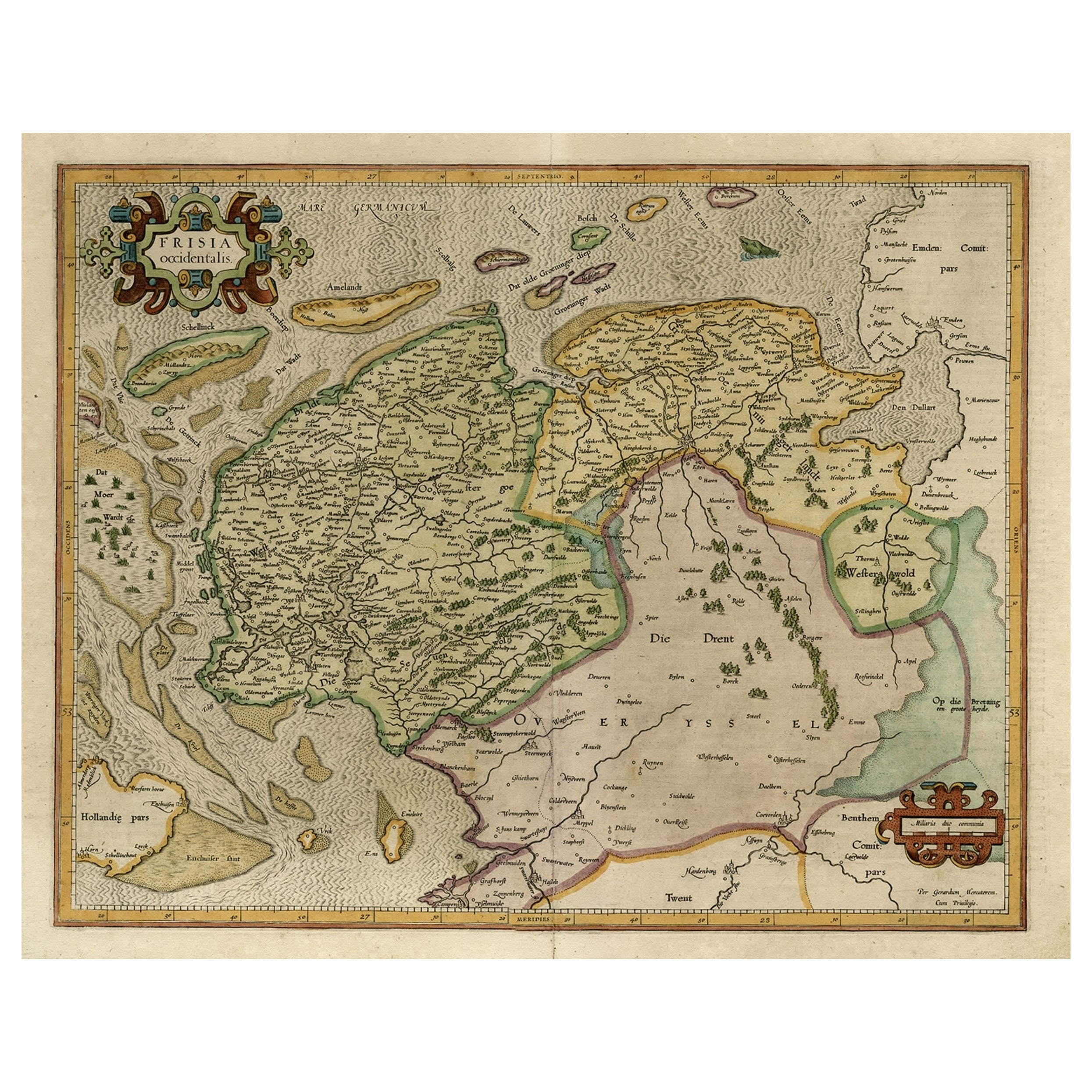
View AllEarly Antique Map of the Dutch Provinces of Friesland and Groningen, 1604
Located in Langweer, NL
Antique map titled 'Frisiae Occidentalis.'
This attractive map shows the Dutch Provinces of Friesland and Groningen. Embellished with strapwork tit...
Category
Antique Early 1600s Maps
Materials
Paper
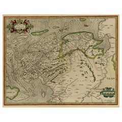
$1,006 Sale Price
25% Off
Old Map of the Dutch Provinces of Friesland and Groningen, The Netherlands, 1604
Located in Langweer, NL
Antique print, titled: 'Frisiae Occidentalis.'
Handsome map of the Dutch Provinces of Friesland and Groningen. Embellished with strapwork title-car...
Category
Antique Early 1600s Maps
Materials
Paper
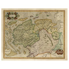
$1,101 Sale Price
20% Off
Antique Map of Friesland with Elaborate Cartouche by Mapmaker Ortelius, c.1570
Located in Langweer, NL
Antique map titled 'Oost end West Vrieslandts beschrijvinghe. Utriusque Frisiorum Regionis Noviss: Descriptio. 1568.' Detailed map of Friesland, the Netherlands. Includes a larger co...
Category
Antique 16th Century Maps
Materials
Paper

$910 Sale Price
20% Off
Antique Map of Friesland 'The Netherlands' by J. Bussemacher, 1596
By Johann Bussemacher
Located in Langweer, NL
Beautiful hand-colored engraving of the province Friesland (The Netherlands). This map originates from the Atlas 'Europae totius orbis terrarium partis praestantissimae, universalis ...
Category
Antique 16th Century European Maps
Materials
Paper
$555 Sale Price
20% Off
Superb Antique Map of the Province of Gelderland, the Netherlands, ca.1575
Located in Langweer, NL
Antique map titled 'Gelriae, Cliviae, Finitimorumque Locorum Verissima Descriptio Christiano Schrot. Auctore'.
This superb map is Ortelius' first plate covering Gelderland. It is b...
Category
Antique 16th Century Maps
Materials
Paper
$1,197 Sale Price
20% Off
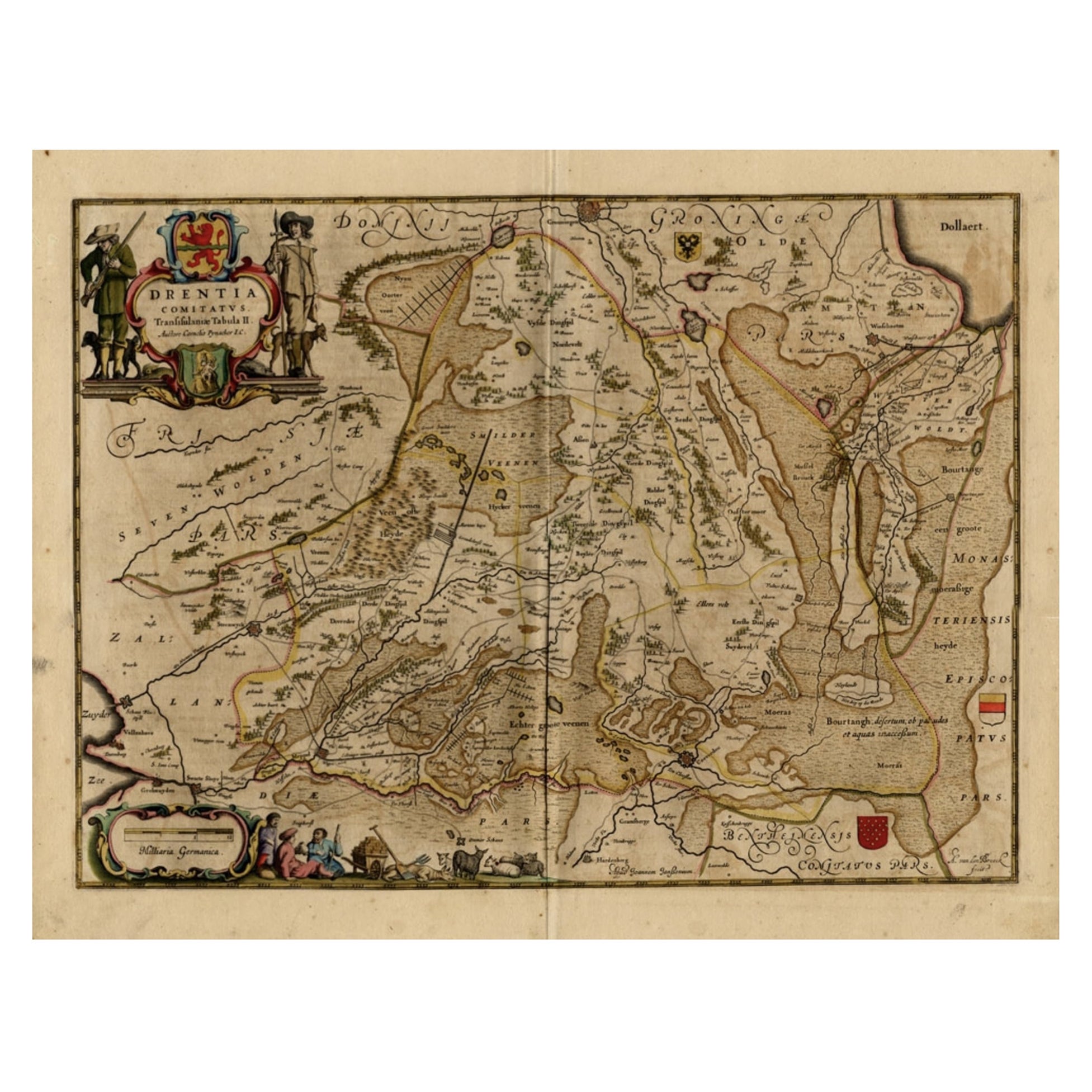
Antique Map of Drenthe, a Province in The Netherlands, 1658
Located in Langweer, NL
Antique map titled 'Drentia comitatus (..)'. Copper engraved contemp. hand coloured map of Drenthe, a province in the Netherlands. Large cartouche with coats of arms. This map is mad...
Category
Antique 17th Century Maps
Materials
Paper

$624 Sale Price
20% Off
You May Also Like
1590 Ortelius Map of Calais and Vermandois, France and Vicinity Ric.a014
Located in Norton, MA
1590 Ortelius map of
Calais and Vermandois, France and Vicinity
Ric.a014
Two rare regional Abraham Ortelius maps on a single folio sheet. Left map, entitled Caletensium, depic...
Category
Antique 16th Century Dutch Maps
Materials
Paper

17th Century Hand-Colored Map of a Region in West Germany by Janssonius
By Johannes Janssonius
Located in Alamo, CA
This attractive highly detailed 17th century original hand-colored map is entitled "Archiepiscopatus Maghdeburgensis et Anhaltinus Ducatus cum terris adjacentibus". It was published ...
Category
Antique Mid-17th Century Dutch Maps
Materials
Paper

Prussia, Poland, N. Germany, Etc: A Hand-colored 17th Century Map by Janssonius
By Johannes Janssonius
Located in Alamo, CA
This is an attractive hand-colored copperplate engraved 17th century map of Prussia entitled "Prussia Accurate Descripta a Gasparo Henneberg Erlichensi", published in Amsterdam by Joannes Janssonius in 1664. This very detailed map from the golden age of Dutch cartography includes present-day Poland, Latvia, Lithuania, Estonia and portions of Germany. This highly detailed map is embellished by three ornate pink, red, mint green and gold...
Category
Antique Mid-17th Century Dutch Maps
Materials
Paper

1643 Willem&Joan Blaeu Map NW Flanders "Flandriae Teutonicae Pars Prientalior
Located in Norton, MA
1643 Willem and Joan Blaeu map of northwest Flanders, entitled
"Flandriae Teutonicae Pars Prientalior,"
Ric0012
" Authentic" - Map of the northwest Fl...
Category
Antique 17th Century Dutch Maps
Materials
Paper

1635 Willem Blaeu Map of Northern France"Comitatvs Bellovacvm" Ric.a08
Located in Norton, MA
1635 Willem Blaeu map of northern France, entitled.
"Comitatvs Bellovacvm Vernacule Beavvais,"
Colored
Ric.a008
“COMITATVS BELLOVACVM…” Amsterdam: W...
Category
Antique 17th Century Unknown Maps
Materials
Paper

17th Century Hand Colored Map of the Liege Region in Belgium by Visscher
By Nicolaes Visscher II
Located in Alamo, CA
An original 17th century map entitled "Leodiensis Episcopatus in omnes Subjacentes Provincias distincté divisusVisscher, Leodiensis Episcopatus" by Nicolaes Visscher II, published in Amsterdam in 1688. The map is centered on Liege, Belgium, includes the area between Antwerp, Turnhout, Roermond, Cologne, Trier and Dinant.
This attractive map is presented in a cream-colored mat measuring 30" wide x 27.5" high. There is a central fold, as issued. There is minimal spotting in the upper margin and a tiny spot in the right lower margin, which are under the mat. The map is otherwise in excellent condition.
The Visscher family were one of the great cartographic families of the 17th century. Begun by Claes Jansz Visscher...
Category
Antique Late 17th Century Dutch Maps
Materials
Paper

More Ways To Browse
Ship Compass Antique
Antique German Compass
Sri Lanka Map
Philippines Map
Antique Map Ceylon
Antique Sri Lanka Map
Persian Maps
Antique Civil War Maps
Antique Map Of The Philippines
Large Map Of Italy
Used Marine Compass
West Indies Colonial
Antique Pamphlets
Sicily Map
Thailand Map
Antique Maps Of Russian Empire
Antique Navigational Tools
Australian Colonial