Items Similar to Early Antique Map of the Dutch Provinces of Friesland and Groningen, 1604
Want more images or videos?
Request additional images or videos from the seller
1 of 5
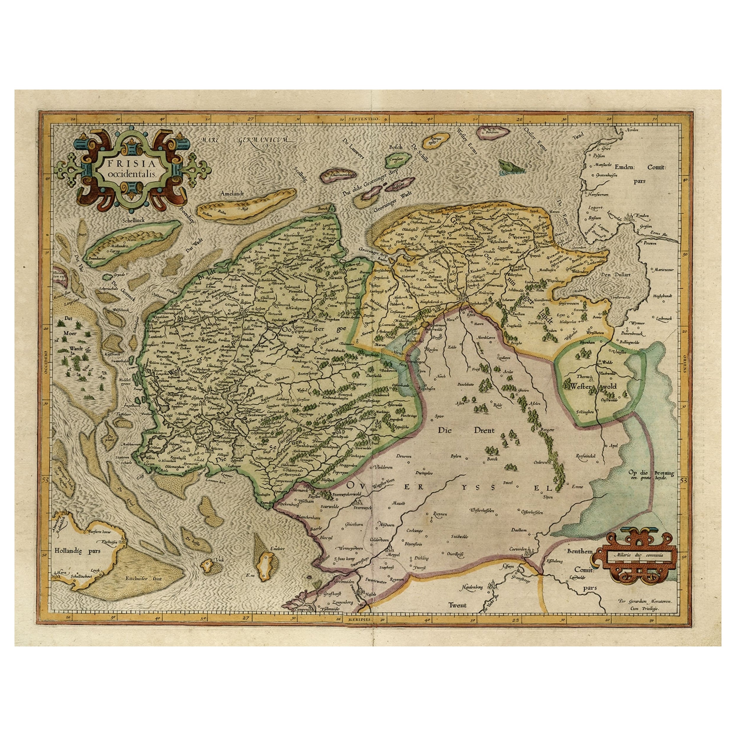
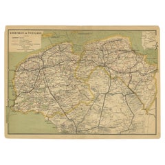
Early Antique Map of the Dutch Provinces of Friesland and Groningen, 1604
About the Item
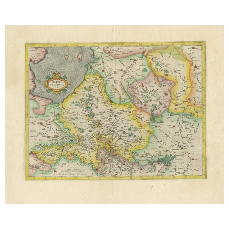
Antique map titled 'Frisiae Occidentalis.'
This attractive map shows the Dutch Provinces of Friesland and Groningen. Embellished with strapwork title-cartouches. Probably from an early ed. of 'Atlas sive cosmographicae meditationes …', by Jodocus Hondius, published after 1604.
Artists and Engravers: Engraved by 'Gerard Mercator' and published by Hondius. Gerard Mercator (Kremer) was born in Rupelmonde in Flanders and studied in Louvain. He made his first map in 1537 and became a cartographer and globe maker. In 1552 he moved to Duisburg, Germany where he published his famous 18-sheet world map in 1569 with his own new projection, today called Mercator projection. Later he decided to publish a new edition of Ptolemy's Geographia. Followed by his major work, a 3 volume collection of maps to which the word "Atlas" was applied the first time. The first volume was published 1585, followed by the second in 1589 and the third one after his death in 1595 by his son Rumold. A second edition of all three parts was published 1602. In 1604 Jodocus Hondius acquired the plates and published several editions together with his sons Jodocus II and Henricus until 1633. More editions followed until 1666 by Janssonius who was in partnership with Henricus. Some of the plated where also used in W.J. Blaeu in 1630.
- Dimensions:Height: 16.93 in (43 cm)Width: 21.07 in (53.5 cm)Depth: 0 in (0.02 mm)
- Materials and Techniques:
- Period:1600-1609
- Date of Manufacture:1604
- Condition:Repaired: Small tear near middle fold and in right surrounding scale edge, reinforced using contemporary paper backed with acid free archival tape. Condition: Original middle fold, as issued. Text on reverse. Print has been in matting, some ghosting on print, which can be hidden again when framed. General age-related toning and/or occasional minor defects from handling. Study scan carefully.
- Seller Location:Langweer, NL
- Reference Number:
About the Seller
5.0
Platinum Seller
These expertly vetted sellers are 1stDibs' most experienced sellers and are rated highest by our customers.
Established in 2009
1stDibs seller since 2017
1,916 sales on 1stDibs
Typical response time: <1 hour
- ShippingRetrieving quote...Ships From: Langweer, Netherlands
- Return PolicyA return for this item may be initiated within 14 days of delivery.
More From This SellerView All
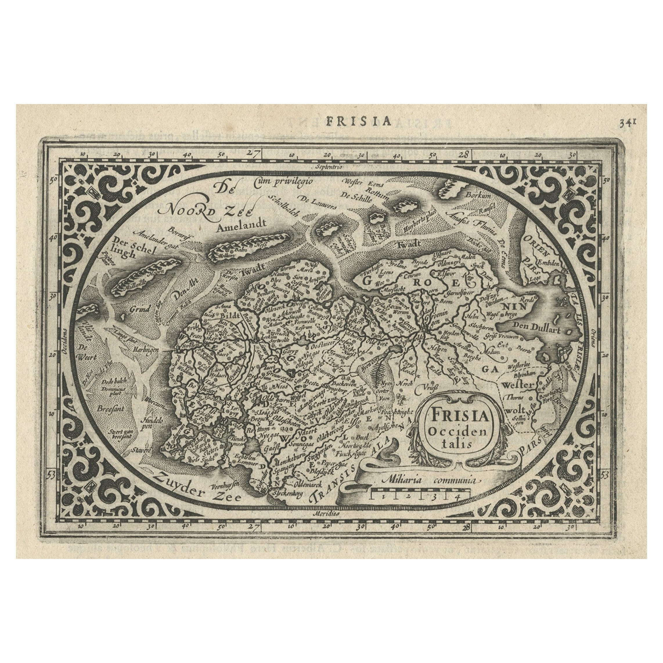
- Old Map of the Dutch Provinces of Friesland and Groningen, The Netherlands, 1604Located in Langweer, NLAntique print, titled: 'Frisiae Occidentalis.' Handsome map of the Dutch Provinces of Friesland and Groningen. Embellished with strapwork title-car...Category
Antique Early 1600s Maps
MaterialsPaper
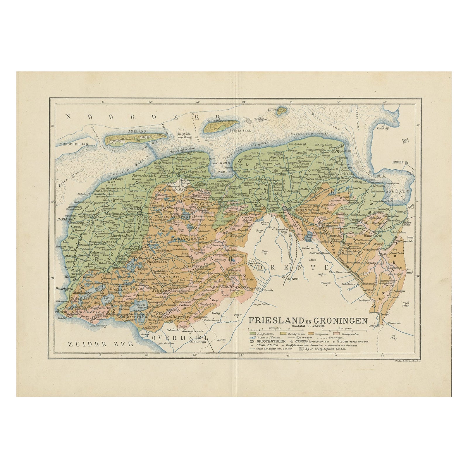
- Antique Map of the Dutch Most Northern Provinces Friesland and Groningen, 1883Located in Langweer, NLAntique map titled 'Friesland en Groningen'. Map of Friesland and Groningen, provinces of the Netherlands. This map originates from 'Atlas van Nederland volgens de nieuwe spelregels'...Category
Antique 19th Century Maps
MaterialsPaper
- Antique Map of Friesland and Groningen, Provinces of the Netherlands, 1628Located in Langweer, NLAntique map Friesland titled 'Frisia Occidentalis'. Small, decorative map of the province of Friesland, the Netherlands. Second state, out of three, originating from 'Atlas Minor' by...Category
Antique 17th Century Maps
MaterialsPaper
- Antique Map of the Dutch Provinces Groningen and Friesland, 1902Located in Langweer, NLAntique map titled 'Groningen en Friesland'. Lithographed map of the provinces of Groningen and Friesland, the Netherlands. This map originates from 'Atlas van Nederland'. Artists an...Category
20th Century Maps
MaterialsPaper
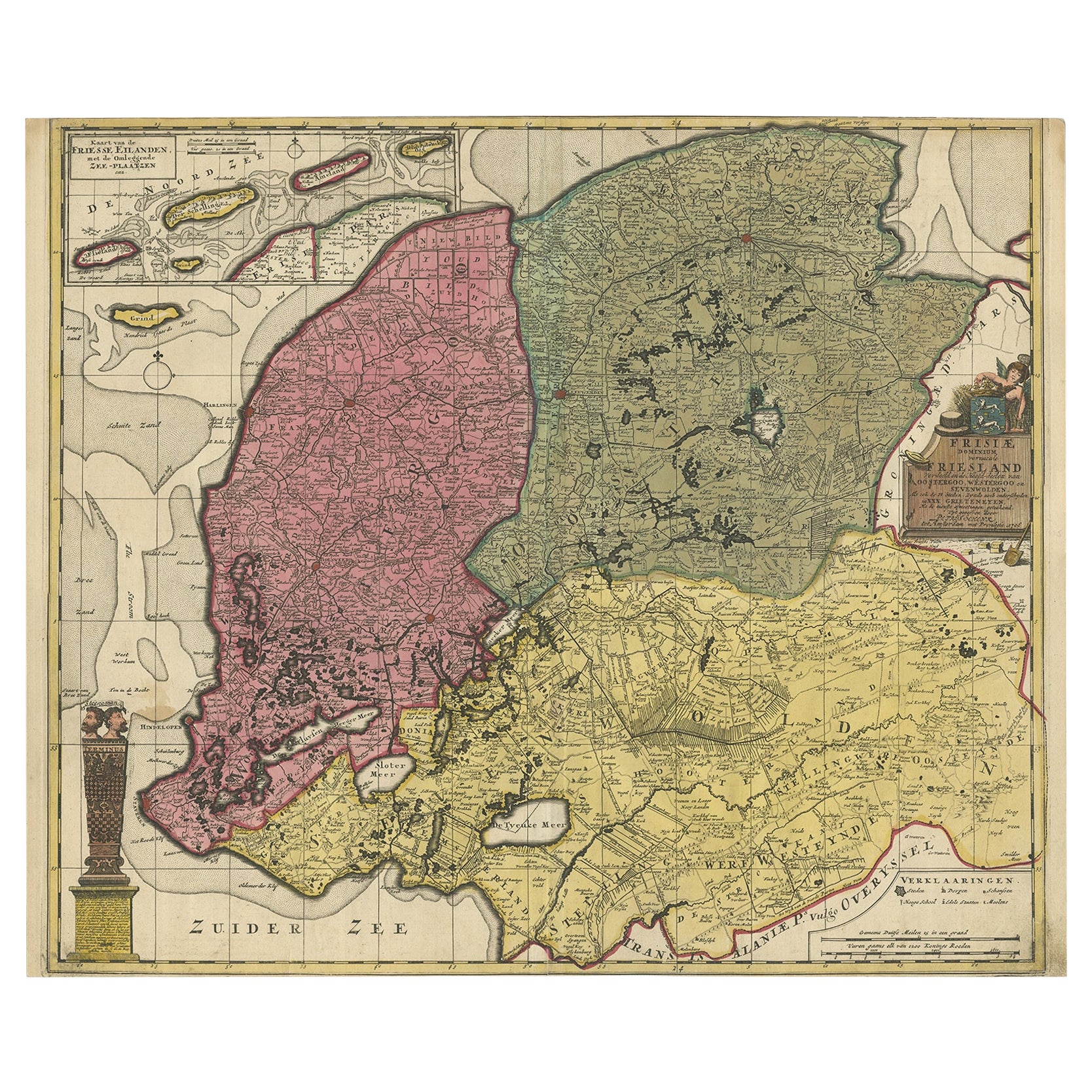
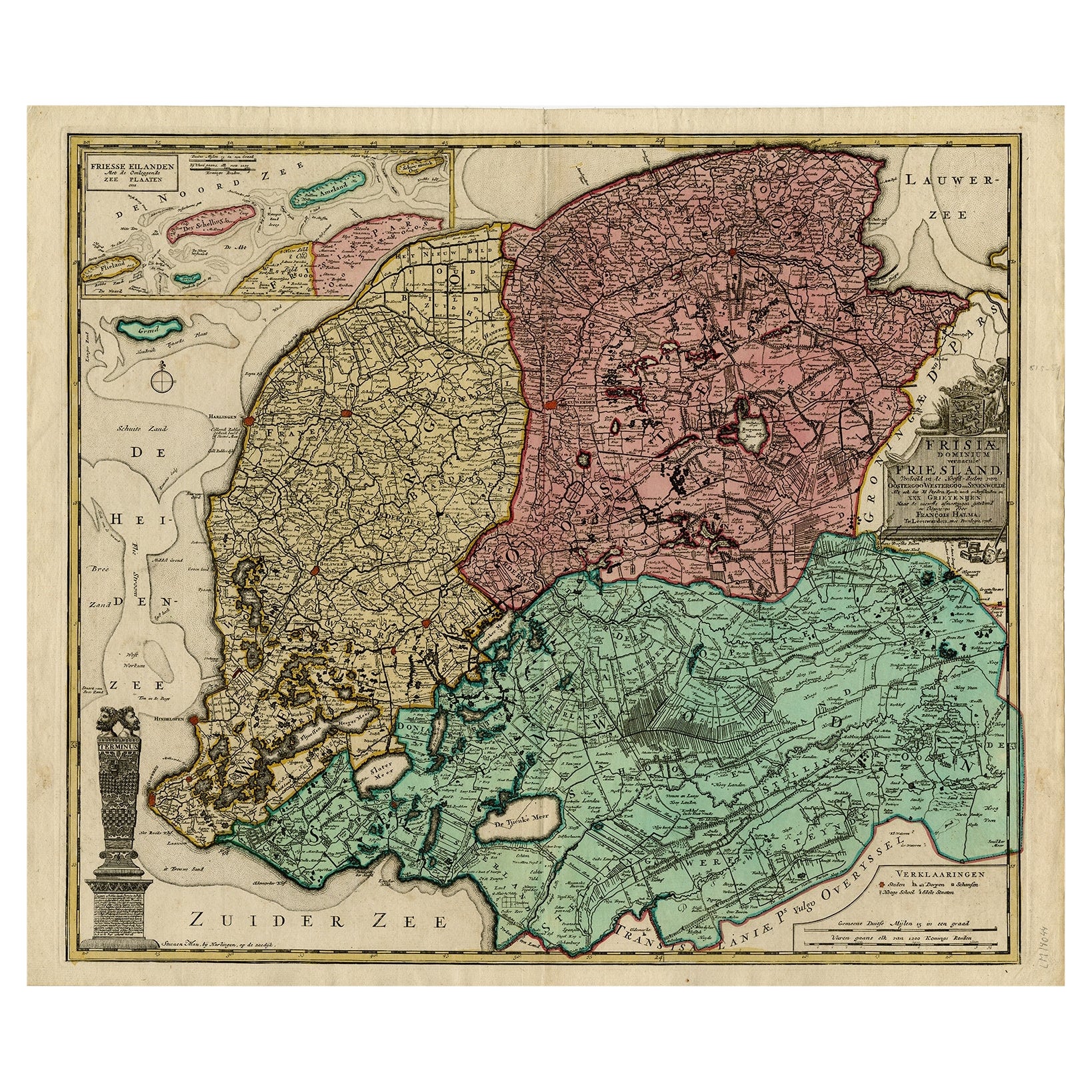
- Detailed Map of Friesland, Groningen and Drenthe, The Netherlands, 1706Located in Langweer, NLAntique map tited 'Frisiae Dominium vernacule Friesland verdeeld met de hoofd-deelen van Oostergoo, Westergoo en Sevenwolden (..)'. Detailed map of Friesland, Groningen and Drenthe, ...Category
Antique 18th Century Maps
MaterialsPaper
- Detailed Antique Map of Friesland, Groningen and Drenthe, The Netherlands, c1735Located in Langweer, NLAntique map titled 'Frisia Dominum (?) Friesland, verdeeld in de hoof-delen van Oostergoo, Westergoo en Sevenwolde (?) XXX Grietenijen.' Detailed map of Friesland, Groningen and Dren...Category
Antique 18th Century Maps
MaterialsPaper

You May Also Like
- The Holy Land at the Time of Jesus: A 17th Century Dutch Map by VisscherBy Nicolaes Visscher IILocated in Alamo, CAThis detailed Dutch map entitled "Het Beloofe de Landt Canaan door wandelt van onsen Salichmaecker Iesu Christo, nessens syne Apostelen" by Nicolaes Visscher was published in Amsterd...Category
Antique Mid-17th Century Dutch Maps
MaterialsPaper
- Map of the Republic of GenoaLocated in New York, NYFramed antique hand-coloured map of the Republic of Genoa including the duchies of Mantua, Modena, and Parma. Europe, late 18th century. Dimension: 25...Category
Antique Late 18th Century European Maps
- Antique Map of Principality of MonacoBy Antonio Vallardi EditoreLocated in Alessandria, PiemonteST/619 - "Old Geographical Atlas of Italy - Topographic map of ex-Principality of Monaco" - ediz Vallardi - Milano - A somewhat special edition ---Category
Antique Late 19th Century Italian Other Prints
MaterialsPaper
- Original Antique Map of The World by Thomas Clerk, 1817Located in St Annes, LancashireGreat map of The Eastern and Western Hemispheres On 2 sheets Copper-plate engraving Drawn and engraved by Thomas Clerk, Edinburgh. Published by Mackenzie And Dent, 1817 ...Category
Antique 1810s English Maps
MaterialsPaper
- Antique 18th Century Map of the Province of Pensilvania 'Pennsylvania State'Located in Philadelphia, PAA fine antique of the colony of Pennsylvania. Noted at the top of the sheet as a 'Map of the province of Pensilvania'. This undated and anonymous map is thought to be from the Gentleman's Magazine, London, circa 1775, although the general appearance could date it to the 1760's. The southern boundary reflects the Mason-Dixon survey (1768), the western boundary is placed just west of Pittsburgh, and the northern boundary is not marked. The map has a number of reference points that likely refer to companion text and appear to be connected to boundaries. The western and southern boundaries are marked Q, R, S, for example. A diagonal line runs from the Susquehanna R to the Lake Erie P. A broken line marked by many letters A, B, N, O, etc., appears in the east. There are no latitude or longitude markings, blank verso. Framed in a shaped contemporary gilt wooden frame and matted under a cream colored matte. Bearing an old Graham Arader Gallery...Category
Antique 18th Century British American Colonial Maps
MaterialsPaper
- Map "Estuary- Mouth of the Thames"Located in Alessandria, PiemonteST/426 - Antique French Map of the estuary of the Thames, map dated 1769 - "Mape of the entrance of the Thames. Designed by filing of Navy cards fo...Category
Antique Mid-18th Century French Other Prints
MaterialsPaper


Recently Viewed
View AllMore Ways To Browse
Antique Globes Of The World
Holland And Sons Furniture
Holland And Sons
Holland And Son
Antique Globes And Maps
Antique Maps And Globes
World Map Globe
Meditation Antique
Mercator Map
Mercator Antique
Antique Map Globe
Map Hondius
Atlas Globe
Antique Map Blaeu
Antique World Globe Map
Map New Holland
Blaeu World Map
Henricus Hondius