Items Similar to Rare Antique Map of the Americas with Island California by Danckerts, c.1680


Want more images or videos?
Request additional images or videos from the seller
1 of 10
Rare Antique Map of the Americas with Island California by Danckerts, c.1680
$3,318.66
$4,148.3320% Off
£2,470.71
£3,088.3920% Off
€2,800
€3,50020% Off
CA$4,572.61
CA$5,715.7620% Off
A$5,091.60
A$6,364.5020% Off
CHF 2,692.56
CHF 3,365.6920% Off
MX$61,961.61
MX$77,452.0120% Off
NOK 33,940.26
NOK 42,425.3220% Off
SEK 31,976.71
SEK 39,970.8920% Off
DKK 21,315.08
DKK 26,643.8520% Off
About the Item
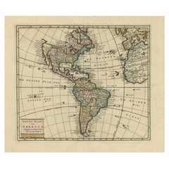
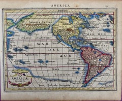
Rare Antique Map of the Americas with Island California by Justus Danckerts, ca. 1696
This exceptional antique map titled Novissima et Accuratissima Totius Americae Descriptio per I. Danckerts presents a richly detailed and decorative depiction of the Americas, engraved and published by Justus Danckerts in Amsterdam around 1696. It is a fine example of late 17th-century Dutch cartography, notable for both its geographic content and elaborate artistic embellishments.
One of the most remarkable features is the depiction of California as an island, a cartographic misconception that appeared frequently in maps of this period and was largely influenced by the model of Nicolas Sanson. The Great Lakes are represented with an open western shoreline, and the map does not show the northwestern coast of North America above 40 degrees latitude, reflecting the limited exploration of the Pacific Northwest at the time. The legendary Seven Cities of Cibola are depicted in the American Southwest, and the Mississippi River is shown in a vague and inaccurate course, placed far west of its actual mouth. A large lake in the southeastern part of North America, first popularized by Le Moyne, is also retained here. South America is shown with a notably wide profile, and a possible Northwest Passage is suggested by an optimistic extension from Button’s Bay in the far north.
The decorative elements are among the highlights of this map. Two large cartouches, one in the top left and one in the lower left, include allegorical figures, native peoples, and exotic animals. The oceans are filled with sailing ships and sea monsters, adding to the visual interest and romantic allure typical of the period. These features make this map not only a document of early geographic knowledge but also an artistic representation of European imagination and ambition regarding the New World.
While maps of the Americas by Visscher and De Wit are more commonly encountered, this edition by Justus Danckerts is considerably rarer and especially prized by collectors of Dutch maps and early American cartography.
Condition report:
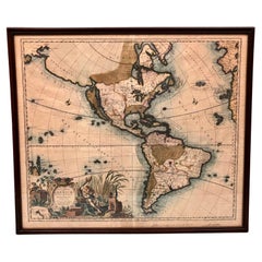
Very good condition overall. The hand coloring is vibrant and well preserved. There may be minor age-toning or faint spots in the margins, but the central image remains clean and sharp. No tears, repairs, or folds are visible.
Framing tips:
A traditional dark wood or gold-leaf frame would enhance the historical character of the map. Use an ivory or light tan acid-free mat to complement the colors and paper tone. Museum-quality glass is recommended to protect the print from light exposure and ensure long-term preservation. This map is ideally suited for display in an office, study, library, or gallery wall focused on travel, history, or exploration.
- Dimensions:Height: 20.48 in (52 cm)Width: 24.22 in (61.5 cm)Depth: 0.02 in (0.5 mm)
- Materials and Techniques:Paper,Engraved
- Place of Origin:
- Period:Late 17th Century
- Date of Manufacture:circa 1680
- Condition:Very good condition overall. The hand coloring is vibrant and well preserved. There may be minor age-toning or faint spots in the margins, but the central image remains clean and sharp. No tears, repairs, or folds are visible.
- Seller Location:Langweer, NL
- Reference Number:Seller: PCT-580221stDibs: LU3054321366342
About the Seller
5.0
Recognized Seller
These prestigious sellers are industry leaders and represent the highest echelon for item quality and design.
Platinum Seller
Premium sellers with a 4.7+ rating and 24-hour response times
Established in 2009
1stDibs seller since 2017
2,567 sales on 1stDibs
Typical response time: <1 hour
- ShippingRetrieving quote...Shipping from: Langweer, Netherlands
- Return Policy
Authenticity Guarantee
In the unlikely event there’s an issue with an item’s authenticity, contact us within 1 year for a full refund. DetailsMoney-Back Guarantee
If your item is not as described, is damaged in transit, or does not arrive, contact us within 7 days for a full refund. Details24-Hour Cancellation
You have a 24-hour grace period in which to reconsider your purchase, with no questions asked.Vetted Professional Sellers
Our world-class sellers must adhere to strict standards for service and quality, maintaining the integrity of our listings.Price-Match Guarantee
If you find that a seller listed the same item for a lower price elsewhere, we’ll match it.Trusted Global Delivery
Our best-in-class carrier network provides specialized shipping options worldwide, including custom delivery.More From This Seller
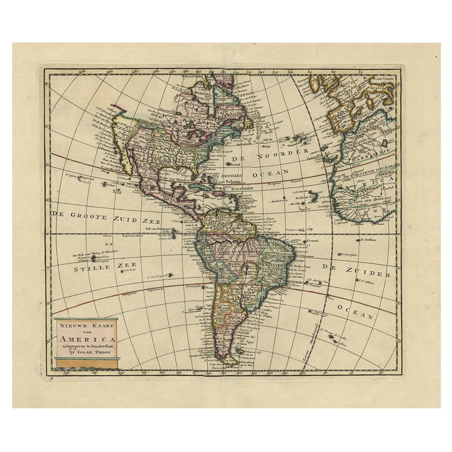
View AllAntique Hand-Coloured Map of North and South America, ca.1765
Located in Langweer, NL
Description: Antique map titled 'Nieuwe Kaart van Amerika.' Attractive map of North and South America, the western part of Africa and south west Europe. Source unknown, to be determi...
Category
Antique 1760s Maps
Materials
Paper
$1,185 Sale Price
20% Off
Antique Map of America with California as an Island by Homann '1710'
Located in Langweer, NL
This antique map, titled "Totius Americae Septentrionalis et Meridionalis," represents a significant cartographic piece from 1710 by Johann Baptist Homann. Here's a description of this remarkable map:
- Title: Totius Americae Septentrionalis et Meridionalis (...)
- Date: Published in 1710 by Johann Baptist Homann.
Description:
This map is a first edition of Johann Baptiste Homann's map of America, and it is notable for several cartographic features and historical representations:
1. California as an Island...
Category
Antique Early 18th Century Maps
Materials
Paper

$2,222 Sale Price
25% Off
Antique Map of South American, The West Indies & Most of Africa, Ca.1775
Located in Langweer, NL
Antique map titled 'Carte pour Servir a l' Histoire Philosophique et Politique des Etablissemens et du Commerce des Europeens dans les deux Indes'.
This map is roughly centered o...
Category
Antique 1770s Maps
Materials
Paper

$720 Sale Price
20% Off
Antique Map of the Americas and West Indies by Robert de Vaugondy, 1778
Located in Langweer, NL
Antique Map of the Americas and West Indies by Robert de Vaugondy, 1778
This detailed antique map titled "Amérique ou Indes Occidentales" was published in 1778 by the renowned Frenc...
Category
Antique Late 18th Century French Maps
Materials
Paper

$1,333 Sale Price
25% Off
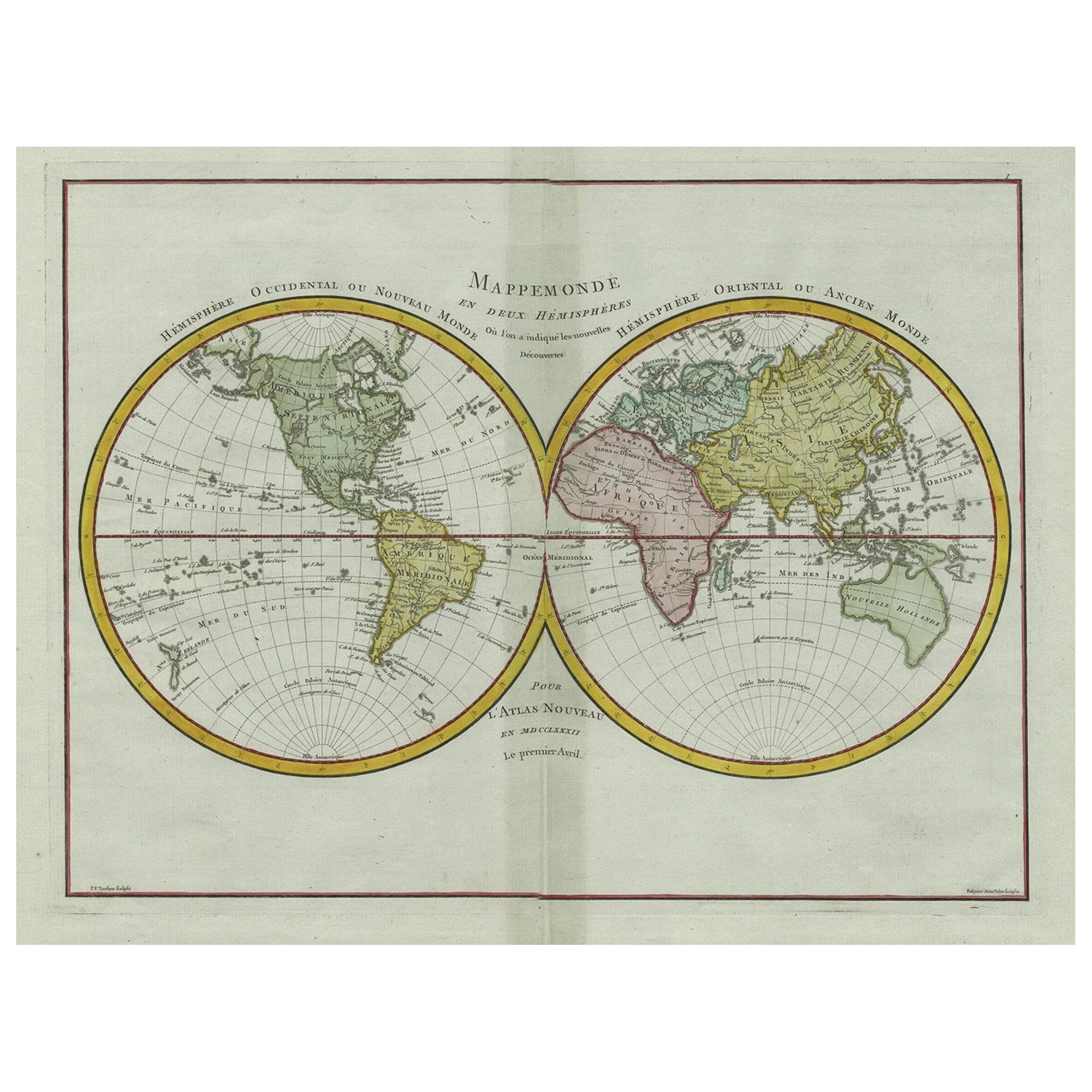
Original Engraved Antique Map of the World, Colorful and Decorative, C.1780
By Pierre François Tardieu
Located in Langweer, NL
Antique map titled 'Mappemonde en Deux Hemispheres ou l'on a Indique les Nouvelles Decouvertes' - This handsome double hemisphere map presents a ...
Category
Antique 18th Century Maps
Materials
Paper

$445 Sale Price
20% Off
Very Decorative Original Antique Map of the World, Published in France in c.1780
By Rigobert Bonne
Located in Langweer, NL
Antique map titled 'L'Ancien Monde Et Le Nouveau en Deux Hemispheres' - Double hemisphere map of the World, showing the contemporary geographical...
Category
Antique 18th Century Maps
Materials
Paper

$733 Sale Price
20% Off
You May Also Like
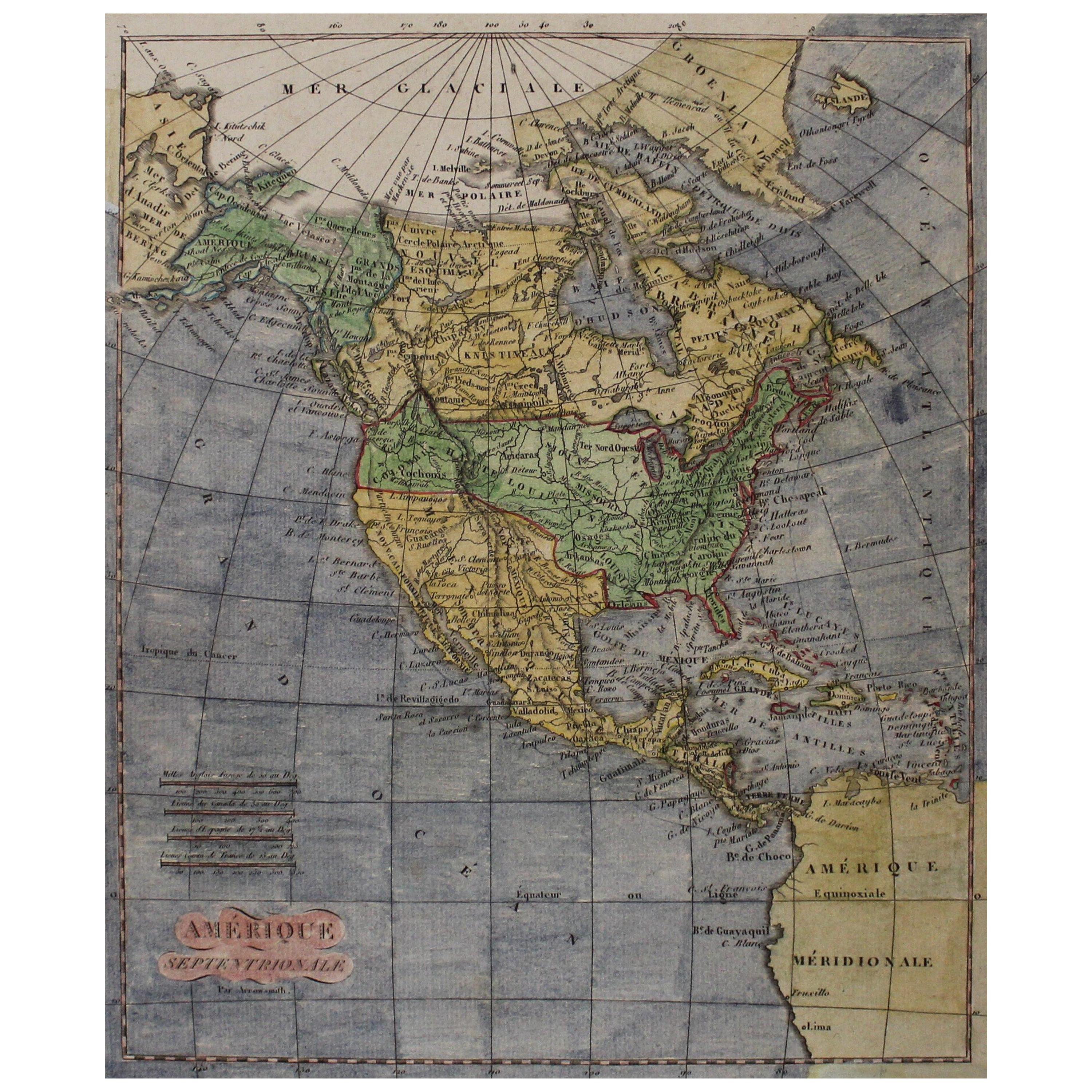
Early 19th Century Hand Coloured Map of North America by Aaron Arrowsmith
By Aaron Arrowsmith
Located in Hamilton, Ontario
Hand coloured map in French by English cartographer Aaron Arrowsmith (1750–1823) titled "Amerique Septentionale" (North America).
Map size: 9.5" x 8"
Mat size: 20.5" x 14.25".
Category
Antique Early 19th Century English Maps
Materials
Paper

$795 Sale Price
36% Off
North & South America: A 17th Century Hand-colored Map by Jansson & Goos
By Johannes Jansson
Located in Alamo, CA
A 17th century hand-colored map of North & South America entitled "Americae Descriptio" by the cartographer Johannes Jansson, published in Jansson's Atlas Minor in Amsterdam in 1628....
Category
1620s Landscape Prints
Materials
Engraving
Early 19th Century Hand Colored Map of the United States and Caribbean Islands
Located in Hamilton, Ontario
Hand coloured early 19th century map by Giraldon of France titled "Etats Unis et Grandes Antilles" (United States and Greater Antilles).
Category
Antique Early 19th Century French Maps
Materials
Paper

$595 Sale Price
40% Off
Original Antique Map of South America. C.1780
Located in St Annes, Lancashire
Great map of South America
Copper-plate engraving
Published C.1780
Two small worm holes to left side of map
Unframed.
Category
Antique Early 1800s English Georgian Maps
Materials
Paper

Map of the World: An Original 18th Century Hand-colored Map by E. Bowen
Located in Alamo, CA
This is an original 18th century hand-colored map entitled "A New & Correct Chart of All The Known World Laid down according to Mercator's Projection" by Emanuel Bowen. It was published in 1744 in London in John Harris's "Navigantium atque Itinerantium Bibliotheca" or "A Complete Collection of Voyages and Travels". This highly detailed and colorful map depicts the world. as it was known in the mid 18th century. A majority of the northern and central portions of Canada and America are left blank due to the purity of knowledge at the time this map was published.
The map is embellished with four Compass Roses in the lower left, lower center, lower right and center, along with many rhumb lines. There a is a decorative title cartouche in the upper left. This colorful, attractive, historical and interesting 1744 map presents the entire world on Mercator's projection as it was understood in the middle part of the 18th century, before the landmark explorations of Captain’s Cook, Vancouver, Wilkes and others. It is an example of a nautical chart, a type of map that was designed specifically for use by mariners. The map is centered on the equator and includes both the Eastern and Western Hemispheres. The continents of North America, South America, Europe, Africa, and Asia are depicted, as well as various islands in the Atlantic, Pacific, and Indian Oceans. The map is laid out according to the Mercator projection, a type of cylindrical map projection that was developed in the 16th century by Flemish cartographer Gerardus Mercator. This projection has the advantage of preserving angles and shapes, making it useful for navigation. The map presents a paucity of inland detail, particularly for the Americas, but major cities, geographical landmarks, and regions are included. Ocean currents and Tradewinds are identified, as well as the magnetic declination lines or magnetic variance, which refers to the difference between true north and compass north. The continents are color coded, enhancing the beauty of this map. The three compass roses indicate the directions of the cardinal points.
The depiction of the western coast of America, the Pacific and Australia are interesting. There was very little exploration of Australia between the navigations of William Damper in 1699 and Tobias Furneaux in 1773. Most of the maps detail relies on the 17th century Dutch expeditions to Australia's western coast, by Abel Tasman and William Janszoon. Van Diemen's Land (Tasmania) and New Guinea appear connected to the Australian continent. New Zealand appears as a single landmass. North of New Zealand there is a landmass labelled 'Ter d' St. Esprit' which probably represents the New Hebrides Islands. This map precedes the accurate exploration of the South Pacific and east coast of Australia by Captain James Cook later in the 18th century. The map includes ‘Drakes' Port,' the site where Sir Francis Drake supposedly landed in 1579 during his 1579 circumnavigation of the globe. Here he claimed territory for England, restocked, and repaired his vessels. Drake named the region New Albion. The exact location of Drake's Port is a cartographic mystery. Drake's Harbor is believed to be in the region of San Francisco Bay, Bodega Bay, San Pablo Bay...
Category
Mid-18th Century Old Masters Landscape Prints
Materials
Engraving

America Septentrionalis by Carroli Allard (1648-1709) Copper Plate Engraving
Located in San Francisco, CA
"Recentissuma Novi Orbis Sive Americae Septentrionale et Meriodionalis"
A hand-colored copper plate engraving of North and South America by Carel Allard depicting recent discoveries...
Category
Antique Late 17th Century Dutch Maps
Materials
Paper
More Ways To Browse
Antique Furniture California
Antique Ivory Collectables
17th Century American Furniture
American Antiques 17th Century
Antique Maps Of North America
Large Wall Maps
Framed World Map
Antique Native American Collectibles
Large Framed Maps
Sea Monster
Map New Holland
Antique Maps Of Long Island
Dutch Sailing Ship
17th Century Dutch Wood Frames
Antique Maps California
California Island Map
Model Sailing Ships
Antique Great Lakes Map