Items Similar to Antique Map of America with California as an Island by Homann '1710'


Want more images or videos?
Request additional images or videos from the seller
1 of 6
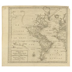
Antique Map of America with California as an Island by Homann '1710'
$2,211.20
$2,948.2725% Off
£1,655.14
£2,206.8525% Off
€1,875
€2,50025% Off
CA$3,043.24
CA$4,057.6625% Off
A$3,392.01
A$4,522.6825% Off
CHF 1,779.67
CHF 2,372.9025% Off
MX$41,422.01
MX$55,229.3525% Off
NOK 22,534.53
NOK 30,046.0425% Off
SEK 21,298.56
SEK 28,398.0825% Off
DKK 14,273.82
DKK 19,031.7625% Off
About the Item
This antique map, titled "Totius Americae Septentrionalis et Meridionalis," represents a significant cartographic piece from 1710 by Johann Baptist Homann. Here's a description of this remarkable map:
- Title: Totius Americae Septentrionalis et Meridionalis (...)
- Date: Published in 1710 by Johann Baptist Homann.
Description:
This map is a first edition of Johann Baptiste Homann's map of America, and it is notable for several cartographic features and historical representations:
1. California as an Island: One of the most distinctive features of this map is the depiction of California as an island. This was a common misconception among cartographers of the time and persisted for several years before being corrected.
2. Straits of Anian: The map shows the Straits of Anian, which were believed to be a potential Northwest Passage, forming a connection between California and the mythical Terra Esonis. This representation reflects the curiosity and exploration of the era when the geography of North America was still being explored and understood.
3. Pays de Moozemleck: East of the Straits of Anian, you can see the "Pays de Moozemleck," a toponym that remained relatively consistent in Homann's maps of America. Despite changes in the depiction of California, this landmark remained largely unchanged, resulting in a somewhat perplexing shift from a coastal to a seemingly landlocked position.
4. Great Lakes and Mississippi River: The map provides detailed information about the Great Lakes and the course of the Mississippi River. The representation of the Mississippi River reflects the explorations conducted by early French Jesuits, with its sources extending farther north than on maps produced a few decades earlier.
5. Le Moyne's Mythical Lake: In the southeastern United States, you can observe a lake with a mystical quality. This lake is associated with Le Moyne's earlier explorations and remained on maps as a reference point.
This antique map offers valuable insights into the evolving understanding of the American continent during the early 18th century. It captures the geographical knowledge, myths, and exploratory spirit of the era and is a significant piece of cartographic history.
- Dimensions:Height: 22.05 in (56 cm)Width: 25.99 in (66 cm)Depth: 0.02 in (0.5 mm)
- Materials and Techniques:
- Period:
- Date of Manufacture:1710
- Condition:Repaired: Repair on folding line. General age-related toning. Professionally restored on folding line and plate marks. Minor wear, blank verso. Please study images carefully.
- Seller Location:Langweer, NL
- Reference Number:Seller: BG-128151stDibs: LU3054321880562
About the Seller
5.0
Recognized Seller
These prestigious sellers are industry leaders and represent the highest echelon for item quality and design.
Platinum Seller
Premium sellers with a 4.7+ rating and 24-hour response times
Established in 2009
1stDibs seller since 2017
2,513 sales on 1stDibs
Typical response time: <1 hour
- ShippingRetrieving quote...Shipping from: Langweer, Netherlands
- Return Policy
Authenticity Guarantee
In the unlikely event there’s an issue with an item’s authenticity, contact us within 1 year for a full refund. DetailsMoney-Back Guarantee
If your item is not as described, is damaged in transit, or does not arrive, contact us within 7 days for a full refund. Details24-Hour Cancellation
You have a 24-hour grace period in which to reconsider your purchase, with no questions asked.Vetted Professional Sellers
Our world-class sellers must adhere to strict standards for service and quality, maintaining the integrity of our listings.Price-Match Guarantee
If you find that a seller listed the same item for a lower price elsewhere, we’ll match it.Trusted Global Delivery
Our best-in-class carrier network provides specialized shipping options worldwide, including custom delivery.More From This Seller
View AllAntique Map of South American, The West Indies & Most of Africa, Ca.1775
Located in Langweer, NL
Antique map titled 'Carte pour Servir a l' Histoire Philosophique et Politique des Etablissemens et du Commerce des Europeens dans les deux Indes'.
This map is roughly centered o...
Category
Antique 1770s Maps
Materials
Paper

$717 Sale Price
20% Off
Rare Antique Map of the Americas with Island California by Danckerts, c.1680
Located in Langweer, NL
Rare Antique Map of the Americas with Island California by Justus Danckerts, ca. 1696
This exceptional antique map titled Novissima et Accuratissima Totius Americae Descriptio per I...
Category
Antique Late 17th Century Dutch Maps
Materials
Paper
Antique Map of the Americas and West Indies by Robert de Vaugondy, 1778
Located in Langweer, NL
Antique Map of the Americas and West Indies by Robert de Vaugondy, 1778
This detailed antique map titled "Amérique ou Indes Occidentales" was published in 1778 by the renowned Frenc...
Category
Antique Late 18th Century French Maps
Materials
Paper

$1,326 Sale Price
25% Off
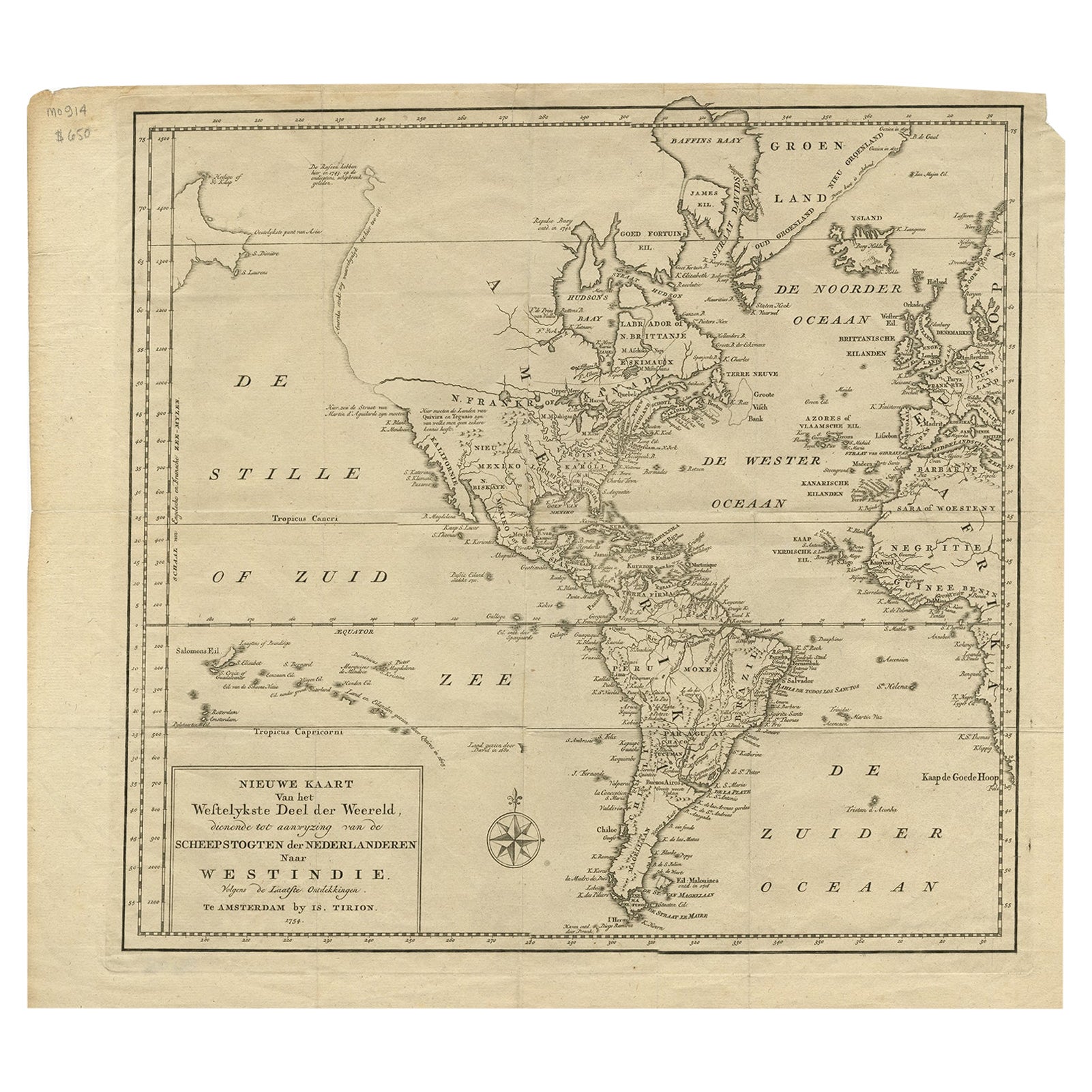
Excellent Antique Map of America with Unusual Northwest Coast of America, c.1754
Located in Langweer, NL
Description: Antique map titled 'Nieuwe Kaart Van het Westelykste Deel Der Weereld, dienende tot aanwyzing an de Scheepstogten der Nederlanderne Naar West Indie.' Excellent map of America, featuring an unusual northwest coast of America, which includes Martin d'Aguilar's strait which provides for a Northwest Passage via the Great Lakes. The rest of the NW coast...
Category
Antique 1750s Maps
Materials
Paper
$542 Sale Price
20% Off
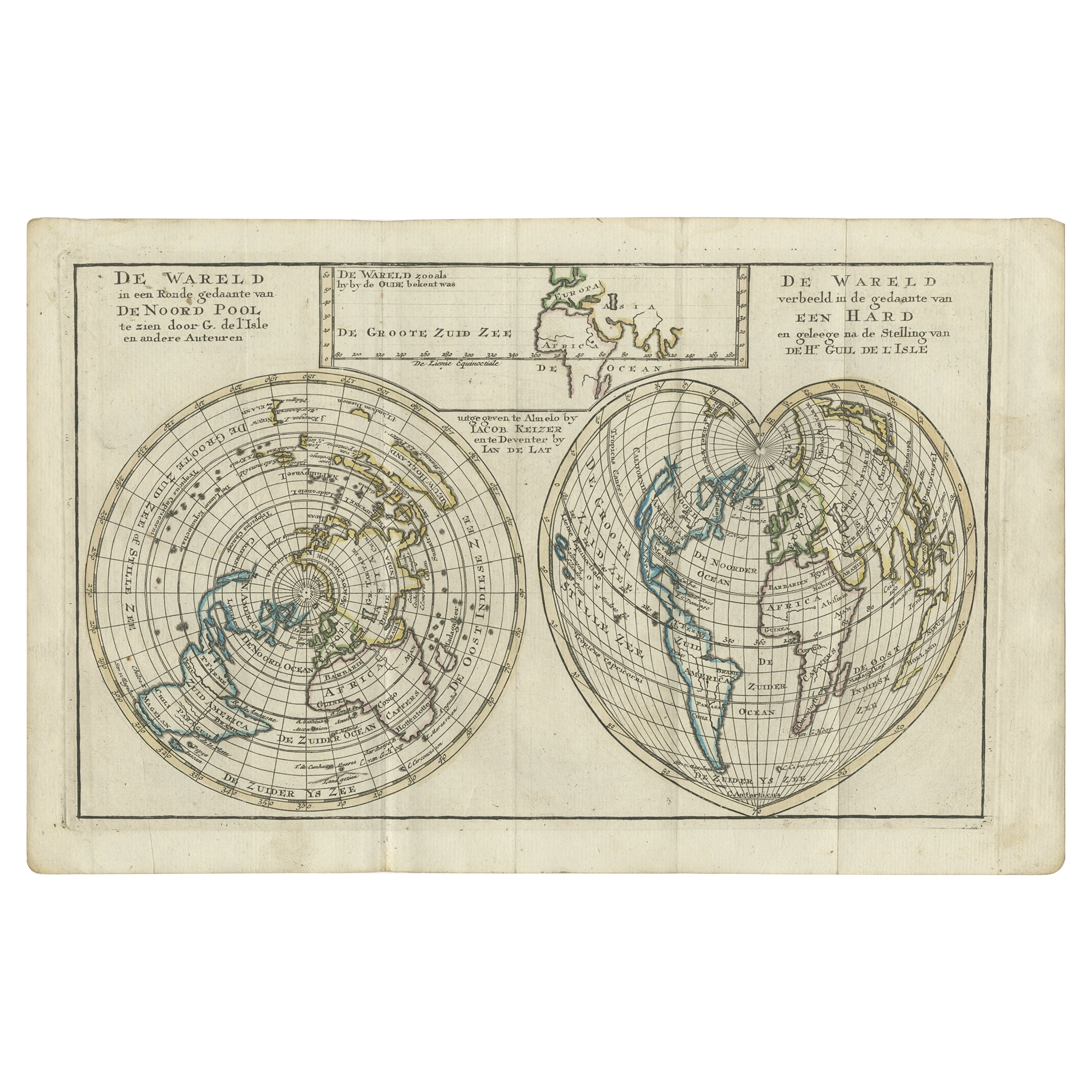
Antique Map of the World with California as an Island, 1788
Located in Langweer, NL
Description: Antique map titled 'De wareld in een ronde gedaante van de Noord Pool te zien - De Wareld verbeeld in de gedaante van een hard'. This interesting composition contains three world maps on the sheet. At left is a northern projection showing all the landmasses. At right is a cordiform projection (heart-shaped). At top is a map of the world as known to the ancients. Both the polar and cordiform projections show California as an island...
Category
Antique 1780s Maps
Materials
Paper

$613 Sale Price
20% Off
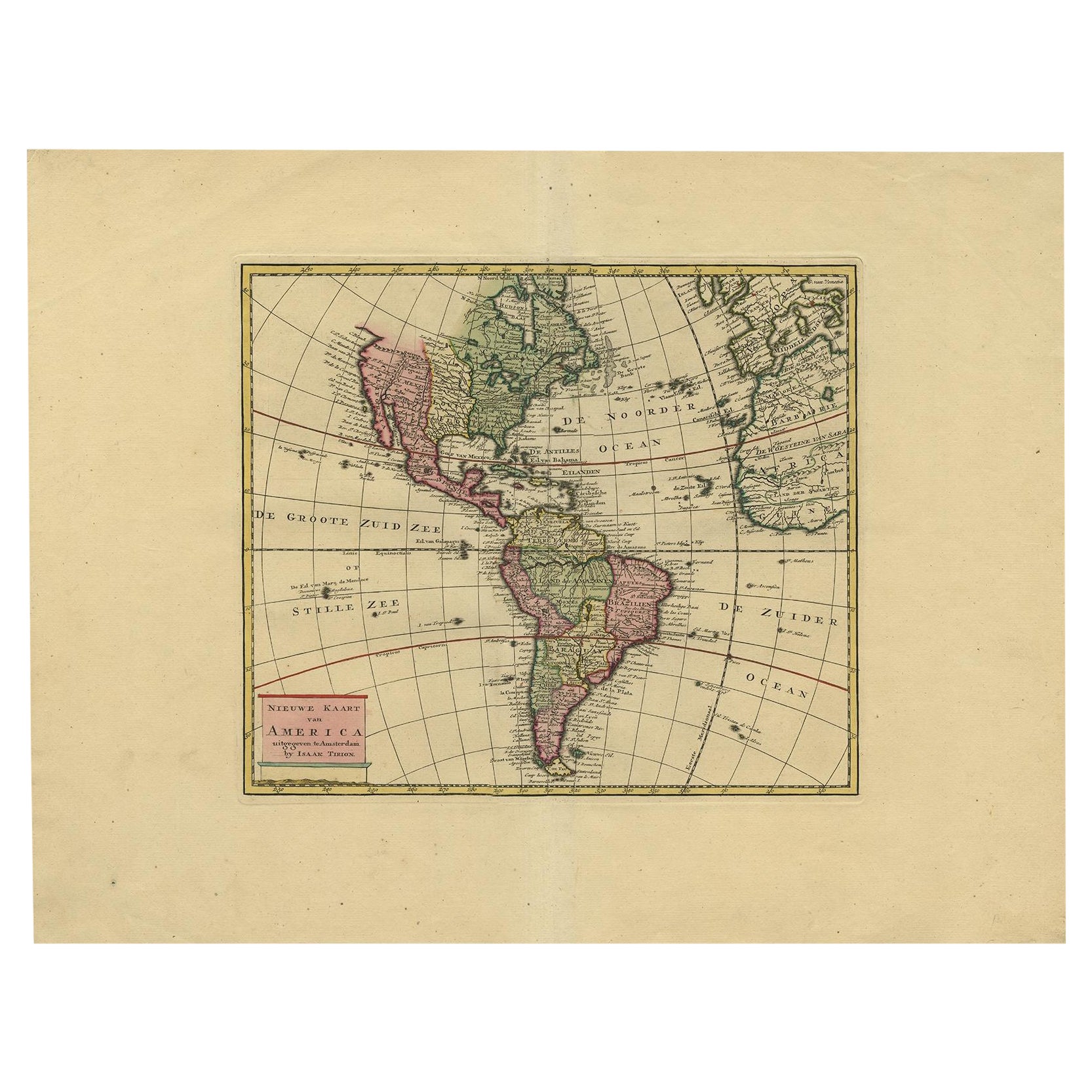
Very Attractive Map of North and South America and Western Part of Africa, 1744
Located in Langweer, NL
Antique map titled 'Nieuwe Kaart van America.' Very attractive map of North and South America, the western part of Africa and south west Europe. With full contemporary hand colouring...
Category
Antique 18th Century Maps
Materials
Paper
$896 Sale Price
20% Off
You May Also Like
North & South America: A 17th Century Hand-colored Map by Jansson & Goos
By Johannes Janssonius
Located in Alamo, CA
A 17th century hand-colored map of North & South America entitled "Americae Descriptio" by the cartographer Johannes Jansson, published in Jansson's Atlas Minor in Amsterdam in 1628....
Category
Antique 1620s Dutch Maps
Materials
Paper

Original Antique Map of South America. C.1780
Located in St Annes, Lancashire
Great map of South America
Copper-plate engraving
Published C.1780
Two small worm holes to left side of map
Unframed.
Category
Antique Early 1800s English Georgian Maps
Materials
Paper

Early 19th Century Hand Coloured Map of North America by Aaron Arrowsmith
By Aaron Arrowsmith
Located in Hamilton, Ontario
Hand coloured map in French by English cartographer Aaron Arrowsmith (1750–1823) titled "Amerique Septentionale" (North America).
Map size: 9.5" x 8"
Mat size: 20.5" x 14.25".
Category
Antique Early 19th Century English Maps
Materials
Paper

$795 Sale Price
36% Off
Antique Map - Mare Pacificum - Etching by Johannes Janssonius - 1650s
By Johannes Janssonius
Located in Roma, IT
Mare Pacificum is an antique map realized in 1650 by Johannes Janssonius (1588-1664).
The Map is Hand-colored etching, with coeval watercolorang.
Good conditions with slight foxing...
Category
1650s Modern Figurative Prints
Materials
Etching

California, Alaska and Mexico: 18th Century Hand-Colored Map by de Vaugondy
By Didier Robert de Vaugondy
Located in Alamo, CA
This is an 18th century hand-colored map of the western portions of North America entitled "Carte de la Californie et des Pays Nord-Ouest separés de l'Asie par le détroit d'Anian, ex...
Category
Antique 1770s French Maps
Materials
Paper

Early 19th Century Hand Colored Map of the United States and Caribbean Islands
Located in Hamilton, Ontario
Hand coloured early 19th century map by Giraldon of France titled "Etats Unis et Grandes Antilles" (United States and Greater Antilles).
Category
Antique Early 19th Century French Maps
Materials
Paper

$595 Sale Price
40% Off
More Ways To Browse
Early California Furniture
Antique Furniture California
18th Century Maps America
Antique Maps California
California Island Map
Antique Great Lakes Map
Antique Mississippi Map
Antique Roman Map
Maps Of Mediterranean
Mercator Map
Antique Railroad Furniture
Atlas Globe
Antique Mississippi Furniture
Framed World Map
Hand Drawn Map
Rare Compass
Antique Furniture Rollers
16th Century Scotland