Items Similar to Antique Map of Fortification of Bellingwolderschans, The Netherlands, 1673
Want more images or videos?
Request additional images or videos from the seller
1 of 5
Antique Map of Fortification of Bellingwolderschans, The Netherlands, 1673
$186.43
$233.0420% Off
£140.60
£175.7520% Off
€160
€20020% Off
CA$257.76
CA$322.2020% Off
A$288.73
A$360.9120% Off
CHF 151.65
CHF 189.5620% Off
MX$3,510.88
MX$4,388.5920% Off
NOK 1,920.41
NOK 2,400.5120% Off
SEK 1,822.98
SEK 2,278.7320% Off
DKK 1,218.02
DKK 1,522.5320% Off
About the Item
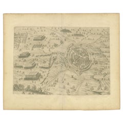
Antique map titled 'Bellingwolderschans'. Original map of the fortification of Bellingwolderschans, the Netherlands. This map originates from 'Teatro del Belgio', by G. Gualdo Priorato.
Artists and Engravers: Author: Galeazzo Gualdo Priorato (1606-1678) entered military service at a very young age and served in Flanders under the Prince of Orange. After his retirement, he authored several historical accounts including the Teatro del Belgio, which described the Catholic/Protestant wars in Belgium and Netherlands during the seventeenth century. His superb plans do not show the internal layout of the cities, except for showing the locations of the major churches. Instead the emphasis is on the fortification, as well as on the surrounding site, rivers and canals. Gaspar Bouttats (1625 - 1695), Flemish engraver.
Condition: Good, general age-related toning. Some wear and creasing, please study image carefully.
Date: 1673
Overall size: 24 x 34 cm.
Image size: 22 x 32.5 cm.
We sell original antique maps to collectors, historians, educators and interior decorators all over the world. Our collection includes a wide range of authentic antique maps from the 16th to the 20th centuries. Buying and collecting antique maps is a tradition that goes back hundreds of years. Antique maps have proved a richly rewarding investment over the past decade, thanks to a growing appreciation of their unique historical appeal. Today the decorative qualities of antique maps are widely recognized by interior designers who appreciate their beauty and design flexibility. Depending on the individual map, presentation, and context, a rare or antique map can be modern, traditional, abstract, figurative, serious or whimsical. We offer a wide range of authentic antique maps for any budget.
- Dimensions:Height: 13.39 in (34 cm)Width: 9.45 in (24 cm)Depth: 0 in (0.01 mm)
- Materials and Techniques:
- Period:
- Date of Manufacture:1673
- Condition:
- Seller Location:Langweer, NL
- Reference Number:Seller: BG-003881stDibs: LU3054326084912
About the Seller
5.0
Recognized Seller
These prestigious sellers are industry leaders and represent the highest echelon for item quality and design.
Platinum Seller
Premium sellers with a 4.7+ rating and 24-hour response times
Established in 2009
1stDibs seller since 2017
2,517 sales on 1stDibs
Typical response time: <1 hour
- ShippingRetrieving quote...Shipping from: Langweer, Netherlands
- Return Policy
Authenticity Guarantee
In the unlikely event there’s an issue with an item’s authenticity, contact us within 1 year for a full refund. DetailsMoney-Back Guarantee
If your item is not as described, is damaged in transit, or does not arrive, contact us within 7 days for a full refund. Details24-Hour Cancellation
You have a 24-hour grace period in which to reconsider your purchase, with no questions asked.Vetted Professional Sellers
Our world-class sellers must adhere to strict standards for service and quality, maintaining the integrity of our listings.Price-Match Guarantee
If you find that a seller listed the same item for a lower price elsewhere, we’ll match it.Trusted Global Delivery
Our best-in-class carrier network provides specialized shipping options worldwide, including custom delivery.More From This Seller
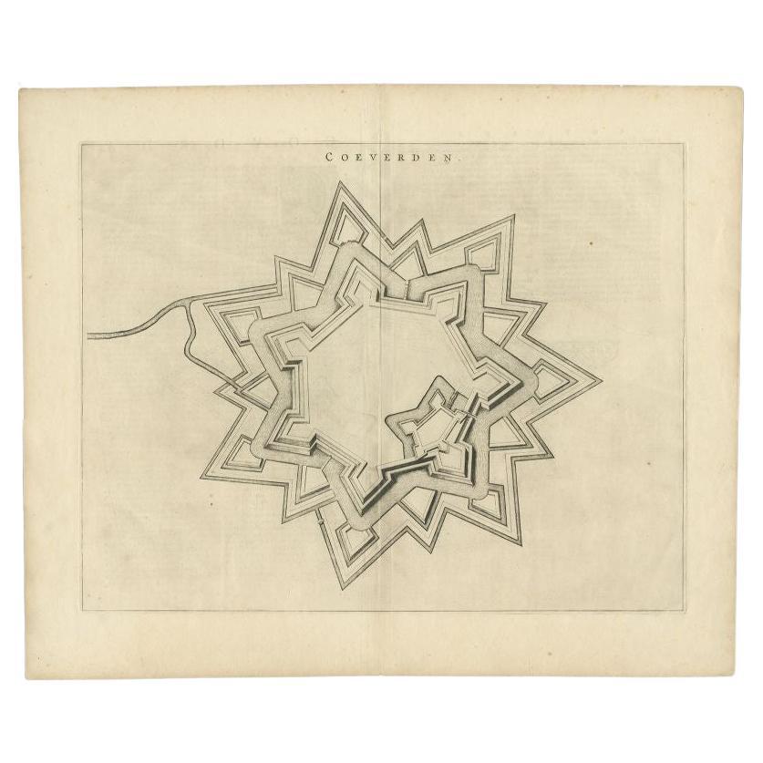
View AllAntique Map of the City of Coevorden by Blaeu, 1649
Located in Langweer, NL
Antique map titled 'Coeverden'. Original map of the city of Coevorden, the Netherlands. This map originates from 'Novum Ac Magnum Theatrum Urbium Belgicae Liberae Ac Foederatae' publ...
Category
Antique 17th Century Maps
Materials
Paper
$211 Sale Price
20% Off
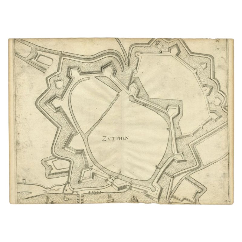
Antique Map of the City of Zutphen, c.1650
Located in Langweer, NL
Antique map titled 'Zutphen'. Uncommon original antique map of the city of Zutphen, the Netherlands. Source unknown, to be determined.
Artists and Engravers: Anonymous.
Conditi...
Category
Antique 17th Century Maps
Materials
Paper
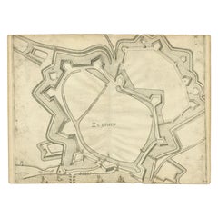
$218 Sale Price
20% Off
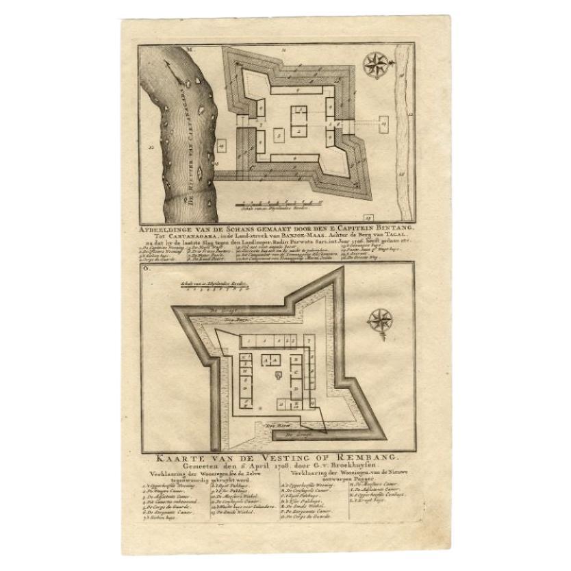
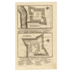
Antique Map of the Fortress of Captain E. Bintang by Valentijn, 1726
Located in Langweer, NL
Antique print titled 'Kaarte van de Schans gemaakt door den E. Capitein Bintang. Kaarte van de Vesting op Rembang.' A plan of the fort constructed by the Captain E. Bintang, in the B...
Category
Antique 18th Century Maps
Materials
Paper
$86 Sale Price
20% Off
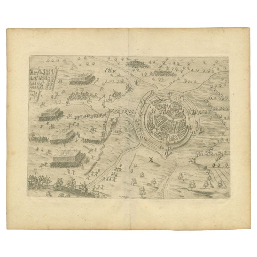
Antique Map of the City of Oldenzaal by Orlers, 1615
Located in Langweer, NL
Antique map depicting the Siege of Oldenzaal, the Netherlands. The Siege of Oldenzaal was a short siege that took place during the Eighty Years' War and the Anglo–Spanish War by a Du...
Category
Antique 17th Century Maps
Materials
Paper
$171 Sale Price
20% Off
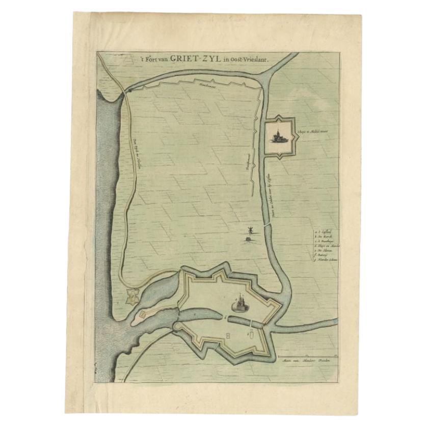
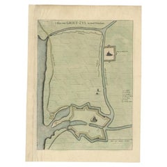
Antique Plan of the Fortress of Greetsiel, Germany, by Blaeu, c.1650
Located in Langweer, NL
Antique plan titled 't Fort van Griet-Zyl in Oost-Vrieslant'. Plan of the fortress of Greetsiel, Germany. This print originates from 'Novum ac magnum theatrum urbium Belgicae' by J. ...
Category
Antique 17th Century Maps
Materials
Paper
$307 Sale Price
20% Off
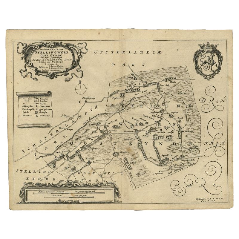
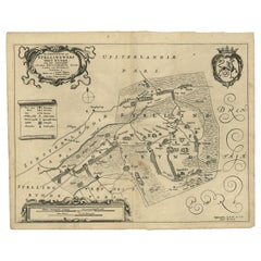
Antique Map of the Region of Ooststellingwerf by Schotanus, 1664
By B. Schotanus
Located in Langweer, NL
Antique map titled 'De Grietenije van Stellingwerf oost eynde (..).' Map of the Grietenij of Ooststellingwerf, Friesland, The Netherlands. Multiple cartouches, key and coat of arms. ...
Category
Antique 17th Century Maps
Materials
Paper
You May Also Like
18th Century Map Engraving - Newport, a Strong Sea-Port Town in Flanders
Located in Corsham, GB
A map of Nieuwpoort, anglicised to 'Newport', in northern Belgium. There is a panorama in the upper quarter depicting major landmarks. Below is a plan of the town, including its strong defences and ships at the port in the lower register. Inscribed with the title in plate to the lower edge, 'Newport a Strong Sea-Port Town...
Category
18th Century More Prints
Materials
Engraving

$269 Sale Price
20% Off
1657 Janssonius Map of Vermandois and Cappelle, Ric. A-004
Located in Norton, MA
1657 Janssonius map of
Vermandois and Cappelle
Ric.a004
Description: Antique map of France titled 'Descriptio Veromanduorum - Gouvernement de la Cappelle'. Two detailed maps o...
Category
Antique 17th Century Unknown Maps
Materials
Paper

Map of the Netherlands - Etching by G. Braun and F. Hogenberg -Late 16th Century
By Franz Hogenberg
Located in Roma, IT
Map of the Netherlands is an original etching realized by George Braun and Franz Hogenberg, as part of the "Civitates Orbis Terrarum".
The “Civitates Orbis Terrarum” (Atlas of Citi...
Category
16th Century Figurative Prints
Materials
Etching

1643 Willem&Joan Blaeu Map NW Flanders "Flandriae Teutonicae Pars Prientalior
Located in Norton, MA
1643 Willem and Joan Blaeu map of northwest Flanders, entitled
"Flandriae Teutonicae Pars Prientalior,"
Ric0012
" Authentic" - Map of the northwest Fl...
Category
Antique 17th Century Dutch Maps
Materials
Paper

1752 Vaugoundy Map of Flanders : Belgium, France, and the Netherlands, Ric.a002
Located in Norton, MA
Large Vaugoundy Map of Flanders:
Belgium, France, and the Netherlands
Colored -1752
Ric.a002
Description: This is a 1752 Didier Robert de Vaugondy map of Flanders. The map de...
Category
Antique 17th Century Unknown Maps
Materials
Paper

1635 Willem Blaeu Map of Northern France"Comitatvs Bellovacvm" Ric.a08
Located in Norton, MA
1635 Willem Blaeu map of northern France, entitled.
"Comitatvs Bellovacvm Vernacule Beavvais,"
Colored
Ric.a008
“COMITATVS BELLOVACVM…” Amsterdam: W...
Category
Antique 17th Century Unknown Maps
Materials
Paper

More Ways To Browse
Antique Navigator
Map Of Middle East
Antique Map Of Switzerland
World Map Copper
British Empire Map
Malaysian Antique Furniture
Birds Eye View Map
Map Of Arabia
Map Of Vienna
Old School Maps
Balinese Wood
Joan Blaeu
Antique Nautical Maps
Antique Portuguese Plates
Antique Maps California
New Zealand Map
Antique Railroad Collectibles
Blaeu World Map