1830s Maps
to
30
61
4
65
2
2,974
2,233
473
3
288
34
9
126
8
36
9
2
5
4
3
2
65
2
2
17
17
17
3
3
65
65
65
Period: 1830s
Dresden Germany, Old Town Plan by Baldwin & Cradock 1833
Located in Langweer, NL
Dresden, depicted in this antique map by Baldwin & Cradock from 1833, was a historically significant city in Saxony, Germany. This map, published under the supervision of the Society...
Category
Antique 1830s Maps
Materials
Paper
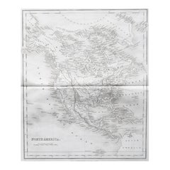
Original Antique Map of North America by Dower, circa 1835
Located in St Annes, Lancashire
Nice map of North America
Drawn and engraved by J.Dower
Published by Orr & Smith. C.1835
Unframed.
Free shipping
Category
English Antique 1830s Maps
Materials
Paper
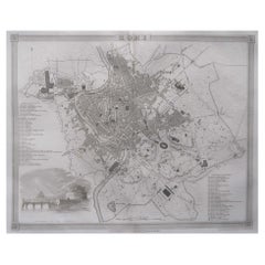
Original Antique Map or City Plan of Rome, Italy. Circa 1835
Located in St Annes, Lancashire
Nice map of Rome
Drawn and engraved by J.Dower
Published by Orr & Smith. C.1835
Unframed.
Free shipping
Category
English Antique 1830s Maps
Materials
Paper
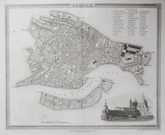
Original Antique Map or City Plan of Venice, Italy. Circa 1835
Located in St Annes, Lancashire
Nice map of Venice
Drawn and engraved by J.Dower
Published by Orr & Smith. C.1835
Unframed.
Free shipping
Category
English Antique 1830s Maps
Materials
Paper
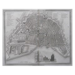
Original Antique Map or City Plan of Amsterdam, Netherlands. Circa 1835
Located in St Annes, Lancashire
Nice map of Amsterdam
Drawn and engraved by J.Dower
Published by Orr & Smith. C.1835
Unframed.
Free shipping
Category
English Antique 1830s Maps
Materials
Paper
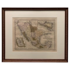
1834 Mexico & Guatemala Framed Map by H.S. Tanner
Located in Stamford, CT
1834 Mexico & Guatemala map of published by H.S. Tanner, Philadelphia, Pennsylvania. Engraved by J. Knight.
As found high end custom framing with carved wood frame, custom matting a...
Category
American American Classical Antique 1830s Maps
Materials
Glass, Wood, Paper
Framed 1838 Mexico & Gulf of Mexico Map
Located in Stamford, CT
Framed 1838 Mexico & Gulf of Mexico map. Printed by Fisher, Son & Co. of London in 1838. As found framed condition. Map has not been examined outside of th...
Category
English American Classical Antique 1830s Maps
Materials
Glass, Wood, Paper
Original Antique Map of Scotland by Dower, circa 1835
Located in St Annes, Lancashire
Nice map of Scotland
Drawn and engraved by J.Dower
Published by Orr & Smith. C.1835
Unframed.
Free shipping
Category
English Antique 1830s Maps
Materials
Paper
Large Folding Map of Paris, France, on Linen, 36 Segments, Published in 1836
Located in Langweer, NL
Antique map Paris titled 'Carte Topographique des Environs de Paris Nouvelle edition rectifié d'apres les travaux de la Nouvelle Carte De France'.
...
Category
Antique 1830s Maps
Materials
Paper
$1,275 Sale Price
20% Off
Antique 1683 Map of Hispaniola and Puerto Rico in the Caribbean by Mallet
Located in Langweer, NL
Title: 17th Century Map of Hispaniola and Puerto Rico by Mallet (1683)
This exquisite 17th-century map by Mallet, titled "I. d'Hispaniola et P.to Rico," showcases the islands of Hispaniola and Puerto Rico with remarkable detail. Published in Paris in 1683 as part of Mallet's monumental "Description de l'Univers," this map is a prime example of historical cartography from the era.
Map Features:
- Detailed depiction of Hispaniola and Puerto Rico
- Nearby islands: Inagua islands, Mayaguana, Île-à-Vache, Saona, and Mona
- Three illustrated naval battles surrounding the islands
- Hand-colored illustrations typical of the period
- Published in Paris, 1683, as part of the "Description de l'Univers"
- Engraved with artistic and geographic precision
Collectors and enthusiasts of antique maps will appreciate the historical significance and artistic detail of this rare print. Although small, the map is perfect for framing and this map serves as a captivating piece of history, reflecting the maritime exploration and territorial knowledge of the late 17th century.
The maker of the map is Allain Manesson Mallet, a notable 17th-century cartographer, military engineer, and author. Born in Paris in 1630, Mallet served in the French army and worked as a military engineer under Louis XIV. He later became a professor of mathematics and military architecture.
Mallet is best known for his monumental work, "Description de l'Univers," published in Paris in 1683. This extensive publication is considered one of the greatest works of its kind in the 17th century, providing detailed descriptions and maps of various parts of the world. Mallet's maps are renowned for their artistic quality, intricate details, and the inclusion of illustrative elements such as ships, sea creatures, and topographical features.
Mallet's contributions to cartography and his work in "Description de l'Univers" have left a lasting impact on the field, making his maps highly valued by collectors and historians.
Keywords:
- 17th-century map
- Mallet map 1683
- Hispaniola map
- Puerto Rico map
- Antique Caribbean map...
Category
Antique 1830s Maps
Materials
Paper
$359 Sale Price
20% Off
Antique Map of Germany c.1830 by Thomas Kelly – Hand-Coloured Copper Engraving
Located in Langweer, NL
Antique Map of Germany by Thomas Kelly, London, circa 1830, with hand colouring
Finely engraved map of Germany titled 'Germany', published by Thomas Kelly at 17 Paternoster Row, London, circa 1830. This historical map outlines the German states, duchies, and surrounding regions including parts of Austria, Switzerland, France, Poland, and Bohemia. Borders are hand-coloured by region, and major rivers, mountain ranges, and cities such as Berlin, Hamburg, Frankfurt, and Munich are clearly marked. Engraved by H. Cooper.
This beautifully detailed copperplate engraving features original hand colouring and displays the political divisions of early 19th-century Germany, including Prussia, Bavaria, Saxony, and Württemberg, along with neighboring regions such as Austria, Switzerland, Bohemia, and parts of Poland and France. Major cities like Berlin, Munich, Hamburg, and Frankfurt are clearly marked, as well as rivers, mountain ranges, and regional borders. Engraved by H. Cooper.
A fine historical map ideal for collectors, interior decorators, or anyone with an interest in European history or cartography.
Technique and material: Copperplate engraving, original hand colouring
Condition report : Good condition. Strong impression with hand colour. Small chips and edge wear to upper margin, not affecting image. Light age toning and minor handling marks. Tight on the left and right margins.
Framing tip:
Use a neutral or antique white mat to highlight the engraved detail. A dark wood or classic gilt frame complements the historical aesthetic. UV-filtering glass recommended to protect the original colouring.
Keywords for SEO:
antique map, map of Germany, 1830s map, hand-colored map, Thomas Kelly map, old Germany map, Prussia map...
Category
Antique 1830s Maps
Materials
Paper
$179 Sale Price
20% Off
Antique 1830 Map of Southern Scotland with Edinburgh, Berwick, Ayr, and Dumfries
Located in Langweer, NL
Title: Antique 1830 Map of Southern Scotland with Edinburgh, Berwick, Ayr, and Dumfries
Description: This 1830 German-language map, titled Britisches Reich – B. Kon Scotland, fo...
Category
Antique 1830s Maps
Materials
Paper
Rare Print of The Factories in Guangzhou, China, 1835
Located in Langweer, NL
Antique print titled 'Factoreries a Canton'.
This print (on india paper) depicts factories in Guangzhou, China. Originates from 'Voyage Autour du Monde par les Mers...
Category
Antique 1830s Maps
Materials
Paper
$689 Sale Price
20% Off
Antique 1830 Map of Scotland with Counties Renfrew, Stirling, Dumbarton and Bute
Located in Langweer, NL
Title: Antique 1830 Map of Scotland with Counties Renfrew, Stirling, Dumbarton, and Bute
Description:
This 1830 German-language map, titled Britisches Reich – B. Kon Scotland, ...
Category
Antique 1830s Maps
Materials
Paper
Old Print Depicting Various Inhabitants of Tonga Tabu, ca.1836
Located in Langweer, NL
Antique print titled 'Tonga-Tabu'.
Old print depicting various inhabitants of Tonga Tabu. This print originates from 'Entdeckungs, Reise der Franzosischen Corvette Astrolabe Unternomen auf Befehl Konig Karls...
Category
Antique 1830s Maps
Materials
Paper
$340 Sale Price
20% Off
Antique 1830 Map of Munster, Ireland with Limerick, Cork, Kerry and Tipperary
Located in Langweer, NL
Title: Antique 1830 Map of Munster, Ireland with Limerick, Cork, Kerry, and Tipperary
Description: This 1830 German-language map, titled Britisches Reich – C. Kon: Ireland, focu...
Category
Antique 1830s Maps
Materials
Paper
1837 Mitchell's "Tourist's Pocket Map of the State of Virginia" by J.H. Young
Located in Colorado Springs, CO
This is J. H. Young's pocket map of the Virginia, which shows county development current to 1835. The map was engraved by E. Yeager and F. Dankworth and published by S. A. Mitchell. ...
Category
American Antique 1830s Maps
Materials
Paper
Steel Engraved Map of Part of the Bengal Presidency 'India & Bangladesh', 1831
Located in Langweer, NL
Antique map titled 'India Bengal Presidency'. Old steel engraved map of part of the Bengal Presidency. The Bengal Presidency (1757–1912), later reorganized as the Bengal Province (19...
Category
Antique 1830s Maps
Materials
Paper
$349 Sale Price
20% Off
Original Antique Print of a Castle in Madrid, Spain, 1833
Located in Langweer, NL
Antique print titled 'Schloss zu Madrid'.
Lithograph of a castle in Madrid, Spain. This print originates from 'Neuen Bildergalerie für die Jugend'.
Artists and Engravers: Ano...
Category
Antique 1830s Maps
Materials
Paper
Antique 1830 Map of Ulster, Ireland with Armagh, Down, Antrim, Donegal, Tyrone
Located in Langweer, NL
Title: Antique 1830 Map of Ulster, Ireland with Armagh, Down, Antrim, Donegal, and Tyrone
Description: This 1830 German-language map, titled Britisches Reich – C. Kon: Ireland, ...
Category
Antique 1830s Maps
Materials
Paper
Original Antique Map of The World by Dower, circa 1835
Located in St Annes, Lancashire
Nice map of the World
Drawn and engraved by J.Dower
Published by Orr & Smith. C.1835
Unframed.
Free shipping
Category
English Antique 1830s Maps
Materials
Paper
Original Antique Map or City Plan of Geneva, Switzerland. Circa 1835
Located in St Annes, Lancashire
Nice map of Geneva
Drawn and engraved by J.Dower
Published by Orr & Smith. C.1835
Unframed.
Free shipping
Category
English Antique 1830s Maps
Materials
Paper
Original Antique Map of Australia by Dower, circa 1835
Located in St Annes, Lancashire
Nice map of Australia
Drawn and engraved by J.Dower
Published by Orr & Smith. C.1835
Unframed.
Free shipping
Category
English Antique 1830s Maps
Materials
Paper
Original Antique Map of The United States of America by Dower, circa 1835
Located in St Annes, Lancashire
Nice map of the USA
Drawn and engraved by J.Dower
Published by Orr & Smith. C.1835
Unframed.
Free shipping
Category
English Antique 1830s Maps
Materials
Paper
Antique Map of the Western Hemisphere by Lapie, France, circa 1830
Located in Langweer, NL
Antique Map of the Western Hemisphere by Lapie, France, circa 1830
This beautifully engraved and delicately hand-colored map, titled Hémisphère du Nouveau Continent (Ouest), depict...
Category
Antique 1830s Maps
Materials
Paper
Antique 1830 Map of Leinster, Ireland with Dublin, Kilkenny, Wexford and Kildare
Located in Langweer, NL
Title: Antique 1830 Map of Leinster, Ireland with Dublin, Kilkenny, Wexford, and Kildare
Description: This 1830 German-language map, titled Britisches Reich – C. Kon: Ireland, f...
Category
Antique 1830s Maps
Materials
Paper
Antique Map of the Eastern Hemisphere by Lapie, France, circa 1830
Located in Langweer, NL
Antique Map of the Eastern Hemisphere by Lapie, France, circa 1830
This finely engraved and hand-colored antique map, titled Hémisphère de l'ancien continent (Eastern Hemisphere), w...
Category
Antique 1830s Maps
Materials
Paper
Original Antique Map or City Plan of Istanbul, Turkey. Circa 1835
Located in St Annes, Lancashire
Nice map of Istanbul
Drawn and engraved by J.Dower
Published by Orr & Smith. C.1835
Unframed.
Free shipping
Category
English Antique 1830s Maps
Materials
Paper
Old Hand-Colored Print of Officers and Horses of the Belgium Army, 1833
Located in Langweer, NL
One nicely hand coloured print of an original serie of 23 plates, showing officers and soldiers discussing matters. published in 1833. Rare.
From a serie of beautiful lithographed...
Category
Antique 1830s Maps
Materials
Paper
$170 Sale Price
20% Off
Original Antique Map or City Plan of Madrid, Spain. Circa 1835
Located in St Annes, Lancashire
Nice map of Madrid
Drawn and engraved by J.Dower
Published by Orr & Smith. C.1835
Unframed.
Free shipping
Category
English Antique 1830s Maps
Materials
Paper
Original Antique Map of The Eastern Hemisphere by Dower, circa 1835
Located in St Annes, Lancashire
Nice map of the Eastern Hemisphere
Drawn and engraved by J.Dower
Published by Orr & Smith. C.1835
Unframed.
Free shipping
Category
English Antique 1830s Maps
Materials
Paper
Original Antique Map of The Western Hemisphere by Dower, circa 1835
Located in St Annes, Lancashire
Nice map of the Western Hemisphere
Drawn and engraved by J.Dower
Published by Orr & Smith. C.1835
Unframed.
Free shipping
Category
English Antique 1830s Maps
Materials
Paper
Original Antique Map of Africa by Dower, circa 1835
Located in St Annes, Lancashire
Nice map of Africa
Drawn and engraved by J.Dower
Published by Orr & Smith. C.1835
Unframed.
Free shipping
Category
English Antique 1830s Maps
Materials
Paper
Original Antique Map of Tasmania, Australia by Dower, circa 1835
Located in St Annes, Lancashire
Nice map of Tasmania
Drawn and engraved by J.Dower
Published by Orr & Smith. C.1835
Unframed.
Free shipping
Category
English Antique 1830s Maps
Materials
Paper
Original Antique Map of India by Dower, circa 1835
Located in St Annes, Lancashire
Nice map of India
Drawn and engraved by J.Dower
Published by Orr & Smith. C.1835
Unframed.
Free shipping
Category
English Antique 1830s Maps
Materials
Paper
Rare Print of the 'Corps Des Guides' of the Belgium Army Regiment, 1833
Located in Langweer, NL
One nicely hand coloured print of an original serie of 23 plates, showing officers and soldiers resting near a village. published in 1833. Rare.
From a serie of beautiful lithographed plates with Belgian military...
Category
Antique 1830s Maps
Materials
Paper
$302 Sale Price
20% Off
Antique Map of Guadeloupe and Dependencies – France Pittoresque, c. 19th Century
Located in Langweer, NL
Antique Map of Guadeloupe and Dependencies – France Pittoresque, c. 19th Century
This finely engraved antique map of Guadeloupe and its dependencies originates from France Pittore...
Category
Antique 1830s Maps
Materials
Paper
Antique 1830 Map of Eastern England with Suffolk, Norfolk Cambridge, Huntingdon
Located in Langweer, NL
Title: Antique 1830 Map of Eastern England with Suffolk, Norfolk, Cambridge, and Huntingdon
Description: This 1830 German-language map, titled Britisches Reich – A. Kon: England,...
Category
Antique 1830s Maps
Materials
Paper
Nicely Hand-Colored Print of a Belgium Army Regiment Riding Horses, 1833
Located in Langweer, NL
One nicely hand coloured print of an original serie of 23 plates, showing officers and soldiers on horses in beautiful army costumes holding spears. published in 1833. Rare.
From a serie of beautiful lithographed plates with Belgian military costumes after Madou and printed by Dero-Becker. Comes from a Belgian military costume album, dedicated to the Belgian King, and financed by subscribers, some 90 Belgian nobility and officers of the Belgian Army...
Category
Antique 1830s Maps
Materials
Paper
$274 Sale Price
20% Off
18th Century Cartographic Depiction of Upper India and Ceylon, 1835
Located in Langweer, NL
An exquisite set of two maps, 'Carte de la Partie Superieure De L'Inde en de Cadu Gange,' masterfully crafted by the renowned 18th-century French cartographer, Charles Marie Rigobert...
Category
Antique 1830s Maps
Materials
Paper
$415 Sale Price
20% Off
Detailed Map of New South Wales, Australia from 1833 by SDUK
Located in Langweer, NL
Detailed Map of New South Wales, Australia from 1833 by SDUK
This historical map of New South Wales, Australia, published in 1833 by the Society for the Diffusion of Useful Knowledg...
Category
Antique 1830s Maps
Materials
Paper
$529 Sale Price
20% Off
Decorative Print of the Belgium Army with Ambulance Troops in the Field, 1833
Located in Langweer, NL
One nicely hand coloured print of an original serie of 23 plates, published in 1833. Rare.
From a serie of beautiful lithographed plates with Belgian military...
Category
Antique 1830s Maps
Materials
Paper
$302 Sale Price
20% Off
Antique View of Syracuse, Sicily, Italy, 1837
Located in Langweer, NL
Antique print titled 'Syracus'. View of Syracuse, Sicily, Italy. Originates from 'Meyers Universum'.
Artists and Engravers: Joseph Meyer (May 9, 1796 - June 27, 1856) was a Germa...
Category
Antique 1830s Maps
Materials
Paper
Antique Map Featuring Turkey, Persia, India, Egypt & Arabia by James Wyld, 1839
Located in Langweer, NL
The map titled "Map of the countries lying between Turkey & Birmah, comprising Asia Minor, Persia, India, Egypt & Arabia and including the Black, Caspian & Red Seas" is an antique ma...
Category
Antique 1830s Maps
Materials
Paper
$359 Sale Price
20% Off
Handcolored Antique Print of Officers and Horses of the Belgium Army, 1833
Located in Langweer, NL
One nicely hand coloured print of an original serie of 23 plates, showing officers and soldiers discussing matters. published in 1833. Rare.
From a serie of beautiful lithographed plates with Belgian military costumes after Madou and printed by Dero-Becker. Comes from a Belgian military costume album, dedicated to the Belgian King, and financed by subscribers, some 90 Belgian nobility and officers of the Belgian Army...
Category
Antique 1830s Maps
Materials
Paper
$151 Sale Price
20% Off
Handcolored Antique Print of the Marine Administration of the Belgium Army, 1833
Located in Langweer, NL
One nicely hand coloured print of an original serie of 23 plates, showing marine officers and soldiers discussing matters on the seaside. published in 1833. Rare.
From a serie of beautiful lithographed plates with Belgian military costumes after Madou and printed by Dero-Becker. Comes from a Belgian military costume album, dedicated to the Belgian King, and financed by subscribers, some 90 Belgian nobility and officers of the Belgian Army...
Category
Antique 1830s Maps
Materials
Paper
$207 Sale Price
20% Off
Two Men in Civilian & Military Outfit from Cochinchine or Southern Vietnam, 1830
Located in Langweer, NL
Antique print titled 'Cochinchine'. Two portaits of Vietnamese men one showing in military attire and the second in civilian dress.
Cochinchina or Cochin-China is a historical ex...
Category
Antique 1830s Maps
Materials
Paper
$614 Sale Price
20% Off
Old Print Depicting Various Utensils of Tongatabu, Site of Tonga's Capital, 1836
Located in Langweer, NL
Antique print titled 'Tonga-Tabu'.
Tongatapu is the main island of the Kingdom of Tonga and site of Tonga’s capital, Nuku?alofa. It is located in Tonga's southern island group, t...
Category
Antique 1830s Maps
Materials
Paper
$302 Sale Price
20% Off
Original French Antique Map of the Russian Empire, 1837
Located in Langweer, NL
Antique map titled 'Tableau Historique et Géographique de L'Empire de Russie'.
Original antique map of the Russian Empire will detailed written information about the chronology, ...
Category
Antique 1830s Maps
Materials
Paper
$274 Sale Price
20% Off
Original Lithograph with a Scene of a Village and Harbour in New Guinea, c.1836
Located in Langweer, NL
Antique print titled 'Ansicht des Dorfes Kuauï'. Im Dory Hafen.
Old print with a scene of a village and harbour in New Guinea. This print originates from 'Entdeckungs, Reise der Franzosischen Corvette Astrolabe Unternomen auf Befehl Konig Karls...
Category
Antique 1830s Maps
Materials
Paper
$340 Sale Price
20% Off
Decorative Antique Print of Fully Uniformed Generals of the Belgium Army, 1833
Located in Langweer, NL
One nicely hand coloured print of an original serie of 23 plates, showing generals discussing matters. published in 1833. Rare.
From a serie of beautiful lithographed plates with Belgian military costumes after Madou and printed by Dero-Becker. Comes from a Belgian military costume album, dedicated to the Belgian King, and financed by subscribers, some 90 Belgian nobility and officers of the Belgian Army...
Category
Antique 1830s Maps
Materials
Paper
$321 Sale Price
20% Off
Rare Hand-Colored Print of a Belgium Army Regiment Near a Windmill, 1833
Located in Langweer, NL
One nicely hand coloured print of an original serie of 23 plates, showing officers and soldiers resting. published in 1833. Rare.
From a serie of beautiful lithographed plates with Belgian military...
Category
Antique 1830s Maps
Materials
Paper
$302 Sale Price
20% Off
Historical Antique Map of Russia, Examining the History of Russia, 1838
Located in Langweer, NL
Antique map titled 'Sketch of the acquisitions of Russia since the Accession of Peter 1st to the Throne'.
Historical map of Russia, examining the history o...
Category
Antique 1830s Maps
Materials
Paper
Old Print of a Building Protecting the Warriors of Chief Palu, Tonga Tabu, 1836
Located in Langweer, NL
Antique print titled 'Anischt eines Schoppens der die Kriegspiroguen des Häuptlings Palu beschirmt'.
Old print of a building protecting the warriors of Chief Palu, Tonga Tabu. This print originates from 'Entdeckungs, Reise der Franzosischen Corvette Astrolabe Unternomen auf Befehl Konig Karls...
Category
Antique 1830s Maps
Materials
Paper
$340 Sale Price
20% Off
Antique Map of Peru and Bolivia, 1836
Located in Langweer, NL
Antique map titled 'Pérou et Bolivia'.
Decorative map of Peru and Bolivia with outline coloring. Originates from 'Atlas Complet Du Precis De La Geograp...
Category
Antique 1830s Maps
Materials
Paper
$321 Sale Price
20% Off
Old Steel Engraved Map of the Western Part of the Madras Presidency, 1831
Located in Langweer, NL
Antique map titled 'India II Madras Presidency'.
Old steel engraved map of the western part of the Madras Presidency. The Madras Presidency, or the Presidency of Fort St. George, a...
Category
Antique 1830s Maps
Materials
Paper
$274 Sale Price
20% Off
1830 Map of Northern England and Durham, Cumberland, Westmorland, Northumberland
Located in Langweer, NL
Title: Antique 1830 Map of Northern England with Durham, Cumberland, Westmorland, and Northumberland
Description: This 1830 German-language map, titled Britisches Reich – A. Kon...
Category
Antique 1830s Maps
Materials
Paper
Antique Map of French Guiana and Cayenne – Circa 1835
Located in Langweer, NL
Antique Map of French Guiana and Cayenne – Circa 1835
This rare 19th-century map of French Guiana, published around 1835, provides a detailed overview of the region, including the...
Category
Antique 1830s Maps
Materials
Paper
Old Handcolored Print of a Regiment of the Belgium Army, 1833
Located in Langweer, NL
One nicely hand colored print of an original serie of 23 plates, showing soldiers discussing matters in a village. published in 1833. Rare.
From a serie of beautiful lithographed plates with Belgian military costumes after Madou and printed by Dero-Becker. Comes from a Belgian military costume album, dedicated to the Belgian King, and financed by subscribers, some 90 Belgian nobility and officers of the Belgian Army...
Category
Antique 1830s Maps
Materials
Paper
$132 Sale Price
20% Off
Print of Commander Laplace Received by a Cochinchinese Mandarin, c.1830
Located in Langweer, NL
Antique print titled 'Reception du Commandant de la Favorite par un Mandarin Cochinchinois'.
Old print of the reception of Laplace, Commander of 'the Favorite'. Laplace was instructed to thoroughly explore the Indian Ocean and the route to the Indies via the Strait of Malacca, between Sumatra and Malaysia, into the China Sea. Originates from the series 'Voyage autour du monde par les mers...
Category
Antique 1830s Maps
Materials
Paper
$510 Sale Price
20% Off

