Late 19th Century Collectibles and Curiosities

to
503
1,371
778
2,207
398
55
41
31
25
15
14
8
7
7
6
4
3
2
2
1
4,407
6,615
13,354
2,719
3,496
4,638
3,051
523
299
588
740
472
896
880
903
662
575
818
706
666
281
214
1,247
608
314
298
272
2,207
2,207
2,207
24
6
5
3
3
Period: Late 19th Century
Late 19th Century Educational Human Anatomical Ear Model German manufacture
Located in Milan, IT
Ear anatomical model, plaster and papier mâché hand painted, depicting the inner and outer ear and the cochlea. German manufacture of the end of the 19th century. Good condition, som...
Category

German Antique Late 19th Century Collectibles and Curiosities

Materials

Plaster

Antique Map of North America by Johnson, '1872'
Located in Langweer, NL
Antique map titled 'Johnson's North America'. Original map of North America, with an inset map of the Hawaiian group or Sandwich Islands. This map originates from 'Johnson's New Illu...
Category

Antique Late 19th Century Collectibles and Curiosities

Materials

Paper

Wood Fireplace Screen with Painted Nautical Yacht Scene on Canvas
Located in Oklahoma City, OK
Wood fireplace screen with a painted circular nautical painting of yacht or pod yacht on the water. A beautiful piece for any living room or country home or beach home. The back ...
Category

English French Provincial Antique Late 19th Century Collectibles and Curiosities

Materials

Canvas, Glass, Wood, Paint

Antique Smooth Face Iron Golf Club by Willie Park of Musselburgh
Located in Oxfordshire, GB
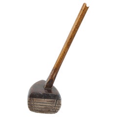
Early smooth face lofting iron by W. Park, Musselburgh. A good early example of a 1880s smooth faced hickory shafted lofting iron by Willie Park, Musselburgh. The shaft is original ...
Category

European Antique Late 19th Century Collectibles and Curiosities

Materials

Iron

Original Map of Greece at the Time of the Dorian Migration, Published in 1880
Located in Langweer, NL
The map titled "GRAECIA TEMPORI MIGRATIONIS DORICAE," translates to "Greece at the Time of the Dorian Migration." This map showcases the regions of ancient Greece during the period f...
Category

Antique Late 19th Century Collectibles and Curiosities

Materials

Paper

Large Original Antique Map of Indiana, USA, 1894
Located in St Annes, Lancashire
Fabulous map of Indiana. Original color. By Rand, McNally & Co. Published, 1894. Unframed. Free shipping.
Category

American Antique Late 19th Century Collectibles and Curiosities

Materials

Paper

Late 19th Century French Hand Carved Oak Child's Chair with Needlepoint Seat
Located in Fayetteville, AR
This late 19th century French oak child's chair features a seat back with hand carved rosettes at the corners, scrolling leaves, a central rosette, and finials. The seat rests on tur...
Category

French Antique Late 19th Century Collectibles and Curiosities

Materials

Upholstery, Oak

Antique Red Cast Iron Star Mill Co. Philadelphia No. 7 Coffee Grinder
Located in Chicago, IL
Antique Red Cast Iron Star Mill Co. Philadelphia No. 7 Coffee Grinder Star Mill Co. cast iron coffee grinder with the original red paint, made in Philad...
Category

American American Craftsman Antique Late 19th Century Collectibles and Curiosities

Materials

Iron

Arctic Exploration: An Original Map of the North Circumpolar Regions, 1882
Located in Langweer, NL
This map, extracted from the 1882 atlas by Blackie & Son, presents the North Circumpolar Regions in a projection centered on the North Pole, offering a unique view of the Arctic territories. The map's radial lines emanate from the pole, focusing on the northernmost parts of continents and the intricate archipelagos that are scattered across the Arctic Ocean. The territories of Canada, Greenland, Northern Europe, Russia, and the northern extremities of Asia are portrayed with careful detail, highlighting the geography known to Victorian explorers. Notably, the map's color palette is subdued, with the cold regions depicted in pale hues, while coastlines and political boundaries are traced in warmer tones, providing a stark contrast that emphasizes the frigid environment. The map likely served purposes both educational and navigational, capturing the extent of polar exploration at the time. Names of seas, straits, and islands honor explorers and patrons of the age of Arctic exploration, and the map also hints at the incomplete knowledge of the era, with some areas less detailed than others, reflecting the limits of exploration and cartographic knowledge of the Arctic region at that time. Moreover, the map includes longitudinal and latitudinal markers, which would have been crucial for navigation and expedition planning. The inclusion of such detail illustrates the growing interest in polar exploration during the late 19th century...
Category

Antique Late 19th Century Collectibles and Curiosities

Materials

Paper

19th Century Carnival Folk Art Carved Wooden Head with Zinc Hat
Located in Haarlem, NL
This head is from a fair or carnival game. Not sure what the game was, perhaps the head has been used to toss rings over, or maybe you were supposed to throw something in his mouth....
Category

Unknown Antique Late 19th Century Collectibles and Curiosities

Materials

Zinc

Yellow Cowboy Slicker
Located in Coeur d'Alene, ID
Yellow oil cloth cowboy slicker with slit back outside pockets and brass buttons. Corduroy collar, no makers mark but there were only 3 makers. Period: Last quarter of the 19th cent...
Category

American Antique Late 19th Century Collectibles and Curiosities

Materials

Fabric

Antique Map of Greece and Ionian Islands by A & C. Black, 1870
Located in Langweer, NL
Antique map titled 'Hellas or Greece'. Original antique map of Greece and Ionian Islands with inset map of Corfu. This map originates from ‘Black's General Atlas of The World’. Publi...
Category

Antique Late 19th Century Collectibles and Curiosities

Materials

Paper

Unusual Crystal Palace Band Competition Painted Glass Certificate of Merit 1883
Located in Bishop's Stortford, Hertfordshire
A very unusual, possibly unique, historical Certificate of Merit awarded at the drum and pipe band contest held at Crystal Palace between 1880 and 1883 and awarded in 1883. The certificate is hand-painted on a rectangular sheet of milk glass and is painted as a hanging cloth banner...
Category

English Victorian Antique Late 19th Century Collectibles and Curiosities

Materials

Milk Glass

Black Sea in Antiquity: Pontus Euxinus Map, Published in 1880
Located in Langweer, NL
This map, titled "PONTUS EUXINUS," depicts the Black Sea region, historically known as the Pontus Euxinus. The Black Sea was central to ancient trade routes and cultural exchange, bo...
Category

Antique Late 19th Century Collectibles and Curiosities

Materials

Paper

Charles GUITEAU. The Crime Avenged: or, Guiteau on the gallows. 1882.
Located in Hillsborough, NJ
AUTHOR: GUITEAU, Charles. TITLE: The Crime Avenged: or, Guiteau on the gallows. A sequel to "Guiteau's Crime" and "The Assassin's Doom," and forming with them a complete secret his...
Category

American Antique Late 19th Century Collectibles and Curiosities

Materials

Paper

Large Original Antique City Plan of San Francisco, USA, 1894
Located in St Annes, Lancashire
Fabulous colorful map of San Francisco Original color By Rand, McNally & Co. Published, 1894 Unframed Free shipping.
Category

American Antique Late 19th Century Collectibles and Curiosities

Materials

Paper

Antique Map of The German Empire (West Sheet), 1882
Located in Langweer, NL
Transport yourself to the heart of history with an original Antique Map of The German Empire (west sheet) from 'The Comprehensive Atlas and Geography of the World,' meticulously craf...
Category

Antique Late 19th Century Collectibles and Curiosities

Materials

Paper

Ancient Cartography of Britannia and Hibernia, Published in 1880
Located in Langweer, NL
This map depicts the geographical area of Great Britain and Ireland, labeled "BRITANNIA et HIBERNIA." It is a historical map, as indicated by the Latin titles and the classical names of regions and tribes. In the main section of the map, Great Britain is depicted in fine detail, with topographical features such as mountains and rivers. The map is color-coded, to differentiate political or tribal boundaries. Various Roman place names are indicated, such as "Londinium" for London. To the left of Great Britain is Ireland, referred to as "Hibernia," similarly detailed with its own topographical features and ancient...
Category

Antique Late 19th Century Collectibles and Curiosities

Materials

Paper

Original Antique City Plan of Kansas City, USA. 1894
Located in St Annes, Lancashire
Fabulous colorful map of Kansas City Original color By Rand, McNally & Co. Published, 1894 Unframed Slightly reduced bottom margin. Free shipping.
Category

American Antique Late 19th Century Collectibles and Curiosities

Materials

Paper

Antique Optometrist's Set, English, Optical Instrument Case, Victorian, C.1900
Located in Hele, Devon, GB
This is an antique optometrist's set. An English, mahogany optical instrument case, dating to the late Victorian period, circa 1900. Offering su...
Category

British Antique Late 19th Century Collectibles and Curiosities

Materials

Wood

Old Map of Southern India and Ceylon 'Sri Lanka', 1882
Located in Langweer, NL
Antique map titled 'India (Southern Sheet)'. Old map of Southern India and Ceylon (Sri Lanka). With an inset map of the South-Eastern Provinces of India. This map originates from...
Category

Antique Late 19th Century Collectibles and Curiosities

Materials

Paper

Christianity Monastery Work Mary & Jesus in Glass Display Case Antique German
Located in Nuernberg, DE
Here I have to offer a fine antique classic early 20th century Glass Display Case with a beautiful Monastery Work inside. A wonderful decorative item, in very nice as is condition. T...
Category

German Folk Art Antique Late 19th Century Collectibles and Curiosities

Materials

Glass, Wood, Paper

An Insightful 19th Century Map of Syria and the Surrounding Regions, 1882
Located in Langweer, NL
This map, titled "SYRIA (SOUTH DIVISION) including PALESTINE & THE HAUARAN," is a historical cartographic work from the late 19th century, specifically from the 1882 atlas by Blackie...
Category

Antique Late 19th Century Collectibles and Curiosities

Materials

Paper

North African Coasts: Marmarica to Mauretania in Roman Times, Published in 1880
Located in Langweer, NL
The map with the title "MARMARICA, CYRENAICA, AFRICA, NUMIDIA, MAURETANIA secundum Italiam Poetarum" presents a historical geographical view of the northern coast of Africa, detailin...
Category

Antique Late 19th Century Collectibles and Curiosities

Materials

Paper

Antique Map of Indiana by Johnson, 1872
Located in Langweer, NL
Antique map titled 'Johnson's Indiana'. Original map of Indiana. This map originates from 'Johnson's New Illustrated Family Atlas of the World' by A.J. ...
Category

Antique Late 19th Century Collectibles and Curiosities

Materials

Paper

Antique Map of Wisconsin with Inset Geological Map of Wisconsin
Located in Langweer, NL
Antique map titled 'Wisconsin'. Original antique map of Wisconsin, United States. With inset geological map of Wisconsin. This print originates from '...
Category

Antique Late 19th Century Collectibles and Curiosities

Materials

Paper

Territories of Antiquity: The Northern Division of Syria, A Detailed 1882 Map
Located in Langweer, NL
This 19th-century map from the atlas published by Blackie and Son in 1882 is titled "SYRIA (NORTH DIVISION)" and covers the northern part of Syria, capturing its geographical and adm...
Category

Antique Late 19th Century Collectibles and Curiosities

Materials

Paper

Antique Map of the Western Part of the German Empire by Levasseur, '1875'
Located in Langweer, NL
Antique map titled 'Empire d'Allemagne (..)'. Large map of the western part of the German Empire. This map originates from 'Atlas de Géographie Moderne Physique et Politique' by A. L...
Category

Antique Late 19th Century Collectibles and Curiosities

Materials

Paper

The World After the Battle of Corupedium: Hellenistic Kingdoms Map, 1880
Located in Langweer, NL
The map is titled "ORBIS TERRARUM post proelium Corupedinse," which translates to "The World after the Battle of Corupedium." This battle, which took place in 281 BC in Lydia, was th...
Category

Antique Late 19th Century Collectibles and Curiosities

Materials

Paper

Mediterranean Tapestry: A 19th Century Map of the Mediterranean Shores, 1882
Located in Langweer, NL
This map, titled "The Shores of the Mediterranean," is part of the 1882 atlas by Blackie & Son, and it portrays the coastal regions that surround the Mediterranean Sea. It is a detailed representation of the diverse and historically rich countries that share the Mediterranean coastline, spanning from the Strait of Gibraltar in the west to the Levantine Sea in the east, and from the southern shores of Europe down to the northern coastlines of Africa. The map is a vivid document of the time, with each country along the Mediterranean basin meticulously outlined. The northern coast includes the southern parts of Europe, featuring Spain...
Category

Antique Late 19th Century Collectibles and Curiosities

Materials

Paper

Imperial Frontiers: A 19th Century Map of Southern Russia and the Caucasus, 1882
Located in Langweer, NL
This map, sourced from the comprehensive 1882 atlas by Blackie & Son, delineates the southern part of Russia and the Caucasus region, reflecting the geopolitical contours and topogra...
Category

Antique Late 19th Century Collectibles and Curiosities

Materials

Paper

Antique L. M. Ericsson AC110 Iron Skeleton Telephone Taxen Eiffel Dachshund #3
Located in Sweden, SE
Desktop telephone model AC 110 (Old catalogue No. 375) made by L. M. Ericsson, Stockholm in period of 1895-1910. A legendary model that enjoys special attention from collectors. Size app.: 30 cm (roughly 11.8 in) high, 27 cm (roughly 10.6 in) wide, 14 cm (roughly 5.5 in) deep. Quite good condition, age and usage wear, attritions, damages, losses of 2 feet out of 4, original finish! Please study high-res pictures for cosmetic condition! In person actual item may appear darker or brighter than in our pictures, strictly depending on sufficient light in your environment. Weight of app. 6 kg it is going to measure some 8 kg packed for shipment. Lars Magnus Ericsson began his association with telephones in his youth as an instrument maker. He worked for a firm which made telegraph equipment for the Swedish government agency Telegrafverket. In 1876, aged 30, he started a telegraph repair shop with help from his friend Carl Johan Andersson. The shop was in central Stockholm (No. 15 on Drottninggatan, the principal shopping street) and repaired foreign-made telephones. In 1878 Ericsson began making and selling his own telephone equipment. His phones were not technically innovative, as most of the inventions had already been made in the US. In 1878, he made an agreement to supply telephones and switchboards to Sweden's first telecom operating company, Stockholms Allmänna Telefonaktiebolag. Also in 1878, local telephone importer Numa Peterson hired Ericsson to adjust some telephones from the Bell Telephone Company. This inspired him to buy a number of Siemens telephones...
Category

Art Nouveau Antique Late 19th Century Collectibles and Curiosities

Materials

Metal, Brass, Bronze

19th Century Reprint of 16th Century Harbor Map of Copenhagen
Located in Haddonfield, NJ
This reprint of 1587 antique map of Copenhagen, Denmark retains its original mid-century mat and has been recently reframed in classic wood frame. The muted sepia colored map is a wo...
Category

Danish Baroque Antique Late 19th Century Collectibles and Curiosities

Materials

Wood, Paper

Original Antique Map of The Austrian Empire, 1882
Located in Langweer, NL
Step into the past with an original Antique Map of The Austrian Empire from the esteemed 'Comprehensive Atlas and Geography of the World,' meticulously crafted in 1882. This intricat...
Category

Antique Late 19th Century Collectibles and Curiosities

Materials

Paper

Antique Map of Winchester, Eldorado & Orangeburg, 1871
Located in Langweer, NL
Antique map titled 'Winchester, Eldorado, Orangeburg'. Original antique map of villages and communities of Ohio. This map originates from 'Atlas of Preble County Ohio' by C.O. Titus....
Category

Antique Late 19th Century Collectibles and Curiosities

Materials

Paper

Colorful Detailed Antique Map of The World on Mercators Projection, 1882
Located in Langweer, NL
The 'World of Mercator's Projection' is a map with a stunning portrayal of global geography and maritime navigation from an era steeped in exploration and discovery. With meticulous detail and precision, this map showcases the world's continents on Mercator's famous projection, capturing the essence of a bygone era's cartographic expertise. Illustrating the courses of chief ocean currents and key navigation tracks between major ports, this map doesn't just depict landmasses but also reveals the vital maritime routes that shaped global trade and exploration. Each line and curve represents the pathways of ancient voyages and modern seafaring, connecting distant shores and continents. Crafted with the precision characteristic of Mercator's projection, this map offers a unique perspective on how sailors and explorers navigated the world's vast oceans. It stands as a testament to the artistry and scientific ingenuity of cartographers of that time, showcasing their commitment to accurate representation amid the challenges of mapping a spherical world on a flat surface. This map isn't just a historical document; it's a captivating piece of cartographic art...
Category

Antique Late 19th Century Collectibles and Curiosities

Materials

Paper

Large Antique French Neoclassical Brass Scale
Located in West Palm Beach, FL
Large Antique French Neoclassical Brass Scale, by Berenger & Co, Lyon France, Circa 1870 A stunning Large Antique French Neoclassical Brass Scale, crafted by the renowned Berenger & Co of Lyon during the mid to late 19th Century. This remarkable brass shop keepers, assay or pharmacist scale...
Category

French Neoclassical Antique Late 19th Century Collectibles and Curiosities

Materials

Brass

Harvard Fraternal Medallion - Delta Kappa Epsilon DKE 1877 Robert P. Hastings
Located in Soquel, CA
Harvard Fraternal Medallion - Delta Kappa Epsilon DKE 1877 Robert P. Hastings Silver Medallion by the Delta Kappa Epsilon Fraternity to Robert P. Hastings Harvard College 1873-1877 The Hastings College of Law was founded by Serranus Clinton Hastings, a man of diverse and magnificent accomplishments. Schoolmaster, lawyer, legislator, member of Congress, Chief Justice...
Category

American American Classical Antique Late 19th Century Collectibles and Curiosities

Materials

Silver

Ancient Gaul: A Cartographic Overview of Gallic Tribes and Roman Provinces, 1880
Located in Langweer, NL
The print titled "GALLIA," is a historical map of ancient Gaul, which corresponds to modern-day France and parts of its surrounding countries. Here are the features and details noted...
Category

Antique Late 19th Century Collectibles and Curiosities

Materials

Paper

Large Original Antique Map of Alabama, USA, C.1900
Located in St Annes, Lancashire
Fabulous map of Alabama Original color Engraved and printed by the George F. Cram Company, Indianapolis. Published, C.1900 Unframed Repair to a minor edge tear top left corner ...
Category

American Antique Late 19th Century Collectibles and Curiosities

Materials

Paper

Boxwood Tailor's and Dressmaker's Square by John T Johnson of Birmingham
Located in London, GB
A boxwood 24 x 18 inch tailor's and dressmaker's square, by John T Johnson of Birmingham, circa 1900. Marked: JOHN T. JOHNSON - UNION PASSAGE. BIRMm.
Category

English Victorian Antique Late 19th Century Collectibles and Curiosities

Materials

Boxwood

Historical Map Depicting the Continent of Asia, 1882
Located in Langweer, NL
This 1882 map presents a meticulously detailed representation of the continent of Asia, a testament to the cartographic skills of the era. Published as a...
Category

Antique Late 19th Century Collectibles and Curiosities

Materials

Paper

Original Antique Map of Russia in Europe, 1882
Located in Langweer, NL
Embark on an enthralling journey with an original Antique Map of European Russia from the esteemed 'Comprehensive Atlas and Geography of the World,' meticulously crafted in 1882. Thi...
Category

Antique Late 19th Century Collectibles and Curiosities

Materials

Paper

L'isle De La Martinique Caribbean Copper Engraving Original Handcoloring, 1704
Located in Langweer, NL
The original hand-colored map titled "Isle de la Martinique," published in 1704 and part of De Fer's Atlas Curieux, is a cartographic masterpiece offering an intricate portrayal of t...
Category

Antique Late 19th Century Collectibles and Curiosities

Materials

Paper

Set of two Antique Maps of the region of Oregon, Idaho, Wyoming, Nebraska & Iowa
Located in Langweer, NL
Set of two individual antique maps of part of the United States. It shows the region and surroundings of Oregon, Idaho, Wyoming, Nebraska, Iowa, Dakota and Wisconsin. Published as pa...
Category

Antique Late 19th Century Collectibles and Curiosities

Materials

Paper

Cartographic Elegance: The British Raj's India, 1882 Atlas by Blackie and Son
Located in Langweer, NL
These two maps are part of an 1882 atlas published by Blackie and Son, a notable publishing company in the 19th century known for their educational books and detailed atlases. The ma...
Category

Antique Late 19th Century Collectibles and Curiosities

Materials

Paper

Original Old Composite of Several Maps of the Ancient World on One Sheet, 1880
Located in Langweer, NL
This original antique map is from Karl Spruner von Merz's "Atlas Antiquus", later edited by Theodorus Menke. The map is a detailed depiction of the ancient world. The atlas it comes ...
Category

Antique Late 19th Century Collectibles and Curiosities

Materials

Paper

Antique 19th Century Map of China by Blackie & Son, 1882
Located in Langweer, NL
This map is an 1882 Blackie & Son map of China. The title "CHINA." is prominently displayed at the bottom. The map is colored to differentiate various regions, possibly indicating di...
Category

Antique Late 19th Century Collectibles and Curiosities

Materials

Paper

Original Antique Map of Italy with an Inset of Sardinia, 1882
Located in Langweer, NL
Embark on a historical odyssey with an original Antique Map of Italy from the esteemed 'Comprehensive Atlas and Geography of the World,' meticulously crafted in 1882. This captivatin...
Category

Antique Late 19th Century Collectibles and Curiosities

Materials

Paper

Large Original Antique Map of Wisconsin, USA, circa 1900
Located in St Annes, Lancashire
Fabulous map of Wisconsin Original color Engraved and printed by the George F. Cram Company, Indianapolis. Published, circa 1900 Unframed  
Category

American Antique Late 19th Century Collectibles and Curiosities

Materials

Paper

Antique Map of Egypt and Palestina by H. Kiepert 'circa 1870'
Located in Langweer, NL
Antique map titled 'Aegyptus, Phoenice et Palestina'. With inset maps of Tyrus, Alexandria and Hierosolyma. This map originates from 'Atlas Antiquus. Zwölf Karten zur Alten Geschicht...
Category

Antique Late 19th Century Collectibles and Curiosities

Materials

Paper

Antique Map of Brazil by Levasseur '1875'
Located in Langweer, NL
Antique map titled 'Carte du Brésil'. Large map of Brazil, with small fold out. This map originates from 'Atlas de Géographie Moderne Physique et Politiq...
Category

Antique Late 19th Century Collectibles and Curiosities

Materials

Paper

Colorful Detailed Antique Map of England and Wales (South Part), 1882
Located in Langweer, NL
Embark on a Journey Through the Southern Part of 'England and Wales' with this Exquisite Antique Map! This map provides a vivid portrayal of the captivating landscapes and cultural h...
Category

Antique Late 19th Century Collectibles and Curiosities

Materials

Paper

Large Original Antique Map of the United States of America. 1891
Located in St Annes, Lancashire
Fabulous map of The United States Original color By Rand, McNally & Co. Dated 1891 Unframed Free shipping.
Category

American Antique Late 19th Century Collectibles and Curiosities

Materials

Paper

Large Original Antique Map of The Environs of Dublin, Ireland, circa 1880
Located in St Annes, Lancashire
Great map of The Environs of Dublin Published circa 1880 Unframed Free shipping.
Category

Scottish Antique Late 19th Century Collectibles and Curiosities

Materials

Paper

Burmese Buddha Throne, Palin, Gilt and Embellished Wood, Mandalay Period, 19th c
Located in Austin, TX
A large and magnificent Burmese gilt and embellished throne or shrine for a Buddha, palin, Mandalay Period, last half of the 19th century, Burma (Myanmar). The impressive throne str...
Category

Burmese Antique Late 19th Century Collectibles and Curiosities

Materials

Tin

An Edinburgh Eleven by J. M. Barrie - creator of PETER PAN
Located in Middletown, NY
FIRST EDITION / FIRST ISSUE An Edinburgh Eleven; Pencil Portraits from College — "British Weekly" Extras, No. III. London: British Weekly Office, 1889. 12mo, 7 x 4 1/2 inches (178...
Category

English Antique Late 19th Century Collectibles and Curiosities

Materials

Gold Leaf

Large Original Antique City Plan of Dublin, Ireland, circa 1880
Located in St Annes, Lancashire
Great city plan of Dublin Published circa 1880 Unframed Free shipping. .
Category

Scottish Antique Late 19th Century Collectibles and Curiosities

Materials

Paper

Read More

Medal-Worthy Memorabilia from Epic Past Olympic Games

Get into the games! These items celebrate the events, athletes, host countries and sporting spirit.

Ahoy! You’ve Never Seen a Collection of Sailor Art and Kitsch Quite Like This

French trendsetter and serial collector Daniel Rozensztroch tells us about his obsession with objects related to seafaring men.

Pamela Shamshiri Shares the Secrets behind Her First-Ever Book and Its Effortlessly Cool Interiors

The sought-after designer worked with the team at Hoffman Creative to produce a monograph that beautifully showcases some of Studio Shamshiri's most inspiring projects.

Moroccan Artworks and Objects Take Center Stage in an Extraordinary Villa in Tangier

Italian writer and collector Umberto Pasti opens the doors to his remarkable cave of wonders in North Africa.

Montecito Has Drawn Royalty and Celebrities, and These Homes Are Proof of Its Allure

Hollywood A-listers, ex-pat aristocrats and art collectors and style setters of all stripes appreciate the allure of the coastal California hamlet — much on our minds after recent winter floods.

Whaam! Blam! Pow! — a New Book on Pop Art Packs a Punch

Publishing house Assouline and writer Julie Belcove have teamed up to trace the history of the genre, from Roy Lichtenstein, Andy Warhol and Yayoi Kusama to Mickalene Thomas and Jeff Koons.

The Sparkling Legacy of Tiffany & Co. Explained, One Jewel at a Time

A gorgeous new book celebrates — and memorializes — the iconic jeweler’s rich heritage.

What Makes a Gem-Encrusted Chess Set Worth $4 Million?

The world’s most opulent chess set, weighing in at 513 carats, is literally fit for a king and queen.

Recently Viewed

View All