Items Similar to Original Antique Map of Peru in South America, 1875


Want more images or videos?
Request additional images or videos from the seller
1 of 6
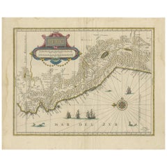
Original Antique Map of Peru in South America, 1875
About the Item
Antique map titled 'Carte générale du Pérou'. Large map of Peru. This map originates from 'Atlas de Géographie Moderne Physique et Politique' by A. Levasseur. Published 1875.
- Dimensions:Height: 24.02 in (61 cm)Width: 18.71 in (47.5 cm)Depth: 0.02 in (0.5 mm)
- Materials and Techniques:
- Period:
- Date of Manufacture:1875
- Condition:General age-related toning, minor wear. Original folding line, blank verso. Please study images carefully.
- Seller Location:Langweer, NL
- Reference Number:
About the Seller
5.0
Platinum Seller
These expertly vetted sellers are 1stDibs' most experienced sellers and are rated highest by our customers.
Established in 2009
1stDibs seller since 2017
1,916 sales on 1stDibs
Typical response time: <1 hour
- ShippingRetrieving quote...Ships From: Langweer, Netherlands
- Return PolicyA return for this item may be initiated within 14 days of delivery.
More From This SellerView All
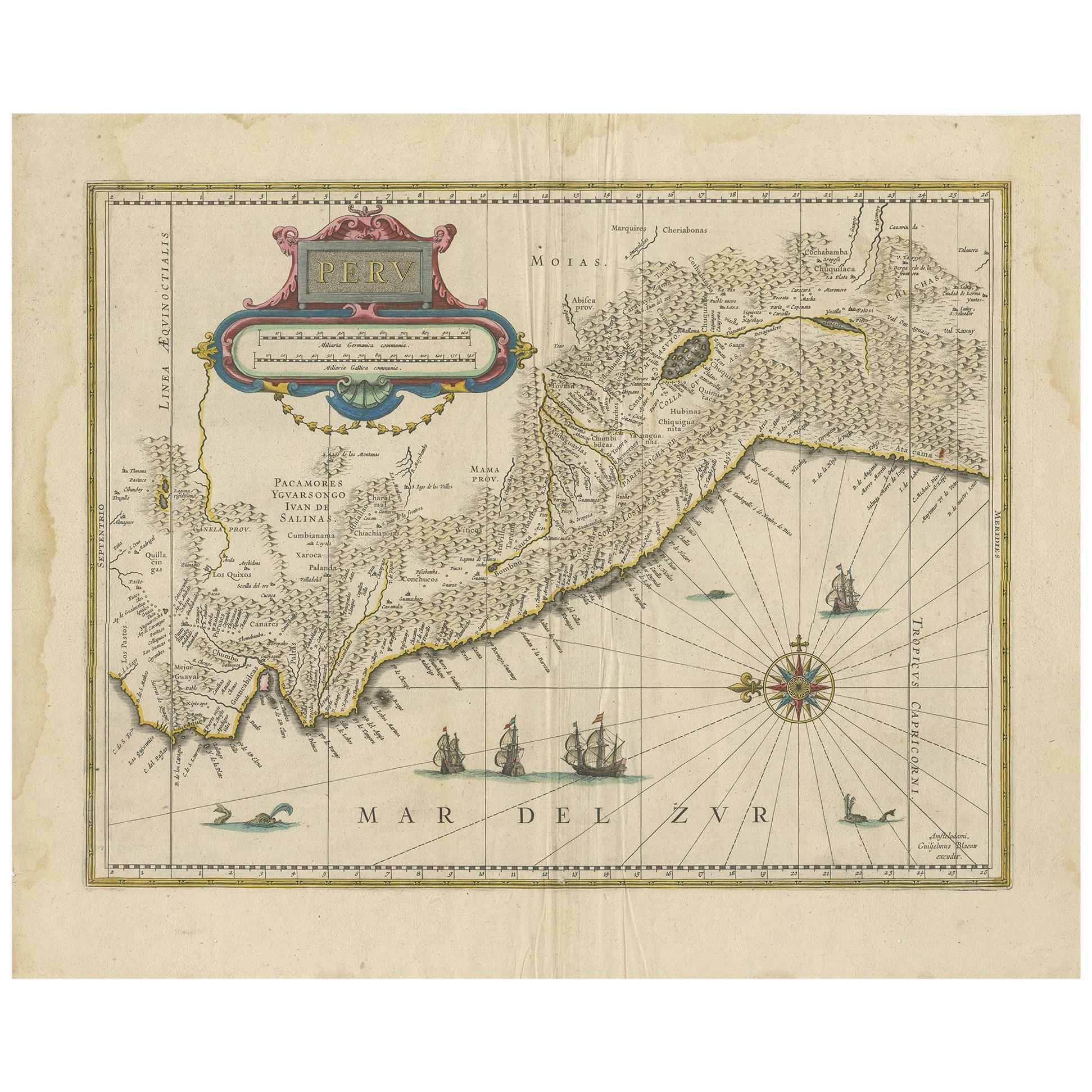
- Antique Map of Peru in South America by Blaeu, circa 1645Located in Langweer, NLAntique map titled 'Peru'. Original antique map of Peru. With cartouche, compass rose, ships and two sea-monsters. Published by W. Blaeu, circa 1645.Category
Antique Mid-17th Century Maps
MaterialsPaper
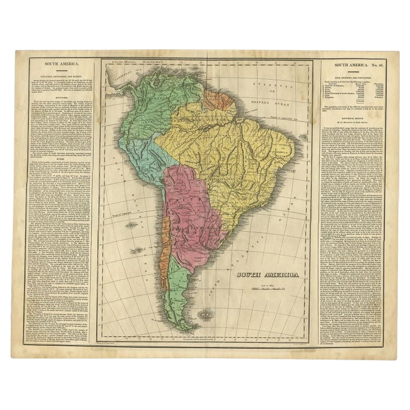
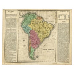
- Interesting Original Antique Map of South America, 1822Located in Langweer, NLAntique map titled 'South America'. Map of South America with attractive topography, surrounded on three sides by text on the history, geography, and economy of the continent. Sh...Category
Antique 19th Century Maps
MaterialsPaper
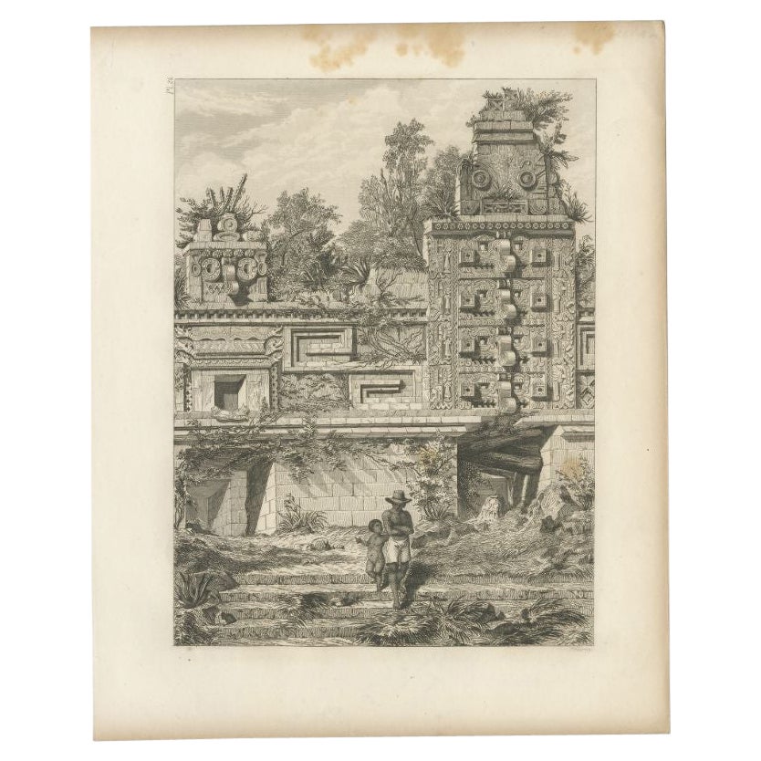
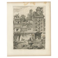
- Antique Print of a Ruin in Peru, South America, 1857Located in Langweer, NLUntitled print of a ruin in Peru. This print originates from 'Die Kunstwerke vom Alterthum bis auf die Gegenwart, oder, Wegweiser durch das ganze Gebiet der bildenden Kunst : enthalt...Category
Antique 19th Century Prints
MaterialsPaper
- Scarce Antique Map of South AmericaLocated in Langweer, NLAntique map titled 'Carte de l'Amérique Méridionale'. Scarce map of South America, published in Paris in 1821. The map shows the continent in the ...Category
Antique Early 19th Century Maps
MaterialsPaper
- Antique Map of North America by Levasseur '1875'Located in Langweer, NLAntique map titled 'Carte générale de l'Amérique Septentrionale'. Large map of North America. This map originates from 'Atlas de Géographie Modern...Category
Antique Late 19th Century Maps
MaterialsPaper
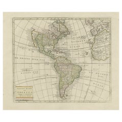
- Original Antique Map of North and South America in Attractive Old ColoringBy Isaak TirionLocated in Langweer, NLAntique map titled 'Nieuwe Kaart van America'. Beautiful map of America. The fabled Quivira is used to name a large mountain range placed just north of Mexico. Published by I. Tirion...Category
Antique Mid-18th Century Maps
MaterialsPaper


You May Also Like
- Original Antique Map of South America. C.1780Located in St Annes, LancashireGreat map of South America Copper-plate engraving Published C.1780 Two small worm holes to left side of map Unframed.Category
Antique Early 1800s English Georgian Maps
MaterialsPaper
- Original Antique Map of South America by Thomas Clerk, 1817Located in St Annes, LancashireGreat map of South America Copper-plate engraving Drawn and engraved by Thomas Clerk, Edinburgh. Published by Mackenzie And Dent, 1817 Unframed.Category
Antique 1810s English Maps
MaterialsPaper
- Original Antique Map of South Africa, Arrowsmith, 1820Located in St Annes, LancashireGreat map of South Africa. Drawn under the direction of Arrowsmith. Copper-plate engraving. Published by Longman, Hurst, Rees, Orme and Br...Category
Antique 1820s English Maps
MaterialsPaper
- Original Antique Map of South East Asia, Arrowsmith, 1820Located in St Annes, LancashireGreat map of South East Asia Drawn under the direction of Arrowsmith Copper-plate engraving Published by Longman, Hurst, Rees, Orme and Brown, 1820 Unframed.Category
Antique 1820s English Maps
MaterialsPaper
- Original Antique Map of Central America / Florida, Arrowsmith, 1820Located in St Annes, LancashireGreat map of Central America. Drawn under the direction of Arrowsmith. Copper-plate engraving. Published by Longman, Hurst, Rees, Orme and Brown, 1820 Unframed.Category
Antique 1820s English Maps
MaterialsPaper
- Original Antique Map of South East Asia by Becker, circa 1840Located in St Annes, LancashireGreat map of South East Asia Steel engraving with original color outline Engraved by Becker Published by Virtue, circa 1840. Unframed.Category
Antique 1840s English Other Maps
MaterialsPaper


Recently Viewed
View AllMore Ways To Browse
Large Antique Maps
Large Antique Map
Antique Map America
Antique American Maps
Antique American Map
America Antique Map
Antique Map Of America
Antique Maps Of America
Antique Peruvian Furniture
Map South America
Map Of South America
Large 19th Century Maps
Antique Peru
Antique Furniture Peru
Peruvian Antiques
Antique Map South America
Antique Maps South America
Antique South America Map