Bartele Gallery
to
203
9,168
5,968
4,453
3,637
2,275
1,396
1,251
1,217
1,118
993
682
525
500
409
394
373
358
334
308
256
249
171
165
163
162
146
143
141
140
137
129
117
116
111
110
87
74
65
62
59
59
56
55
48
41
35
33
19
19
17
8
5
4
2
2
1
Period: 1850s
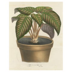
Regal Prayer Plant: Hand-Colored Lithograph by Louis van Houtte, 1855
Located in Langweer, NL
Maranta Regalis: A Hand-Colored Lithograph from Louis van Houtte's Flore des Serres et des Jardins de l'Europe (1854-1855)
This hand-colored lithograph, created between 1854 and 185...
Category
Antique 1850s Prints
Materials
Paper
$230 Sale Price
20% Off
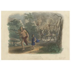
Burning of a Village in Chahary, Madagascar: Hand-Colored 19th Century Engraving
Located in Langweer, NL
This hand-colored engraving titled "Madagascar - Incendie d’un Village de Chahary" (Burning of a Village in Chahary, Madagascar) depicts a dramatic and intense scene in which a villa...
Category
Antique 1850s Prints
Materials
Paper
$134 Sale Price
20% Off
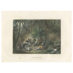
Capture of the Ravine aux Couleuvres in Saint-Domingue: Engraving of circa 1855
Located in Langweer, NL
This hand-colored engraving depicts a dramatic battle scene titled "St. Domingue - Prise de la Ravine aux Couleuvres" (Capture of the Ravine of Snakes in Saint-Domingue). The image s...
Category
Antique 1850s Prints
Materials
Paper
$134 Sale Price
20% Off
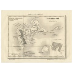
Guadeloupe and Dependencies: Mid-19th Century Map from France Pittoresque Series
Located in Langweer, NL
This map titled "Guadeloupe et Dépendances" is part of the France Pittoresque series and provides a detailed view of the island of Guadeloupe and its surrounding dependencies.
Features:
- The map shows the two main landmasses of Guadeloupe: Basse-Terre and Grande-Terre, separated by a narrow channel.
- Several smaller islands, including Marie-Galante, Les Saintes, and La Désirade, are also depicted.
- The main cities, towns, and geographical features are labeled, with emphasis on the island's mountain ranges and rivers, particularly on Basse-Terre.
- An inset at the bottom right provides a detailed plan of Pointe-à-Pitre, a major city and port on the island. The grid layout of the streets is clearly shown, reflecting urban planning of the time.
Artistic and Cartographic Details:
- The map uses clear linework to differentiate between the different islands and the sea, with significant natural features such as mountains and rivers carefully depicted.
- The map was drawn by Monin and engraved by Jacqueline and Barrière, whose names appear in the lower right corner.
- The scale in the lower left corner is measured in leagues, showing distances both by land and sea.
Historical Context:
- This map likely dates to the mid-19th century, a period when Guadeloupe was a key French colony in the Caribbean. Guadeloupe was known for its sugar and coffee plantations, which played a significant role in France's colonial economy.
- Maps like this were often used for administrative, military, and educational purposes to give a comprehensive view of France's overseas territories.
The map of Guadeloupe et Dépendances from the France Pittoresque series likely dates to the mid-19th century, around 1840 to 1860. This period corresponds to the height of French colonial influence in Guadeloupe, and the map's style, detailed urban planning, and cartographic techniques are consistent with maps produced in that era.
The specific publication date could be further narrowed down if the map was part of a known edition of the France Pittoresque atlas, but based on the cartographic style and historical context, 1840–1860 is a reasonable estimate.
Here are some relevant keywords people might use when searching for a map of Guadeloupe and its surrounding areas:
1. Guadeloupe map
2. Basse-Terre and Grande-Terre map
3. French Caribbean islands map...
Category
Antique 1850s Maps
Materials
Paper
$115 Sale Price
20% Off
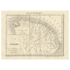
French Guiana and Cayenne: Mid-19th Century Map from France Pittoresque Series
Located in Langweer, NL
This map titled "Guyane" is part of the France Pittoresque series and provides a detailed view of French Guiana along with a plan of the city of Cayenne.
Features:
- The map showcases the broader region of French Guiana, indicating key rivers, settlements, and the coastline along the Atlantic Ocean.
- To the left, there's an inset labeled "Plan de la Ville de Cayenne", which shows the street layout, squares, and main buildings of the capital city, Cayenne. This inset provides a more detailed view of the urban area, highlighting its geometric grid layout near the coast.
- The larger map outlines geographical features such as rivers (e.g., Oyapock and Maroni), forests, and territories in the surrounding area, including the neighboring Brazilian Empire...
Category
Antique 1850s Maps
Materials
Paper
$115 Sale Price
20% Off
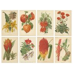
Original Vintage Botanical Illustrations from Revue Horticole, circa 1855
Located in Langweer, NL
Here are descriptions of the eight botanical illustrations, including the Latin and English names of the plants, why they are significant, and details about the creators and the tech...
Category
Antique 1850s Prints
Materials
Paper
$641 Sale Price / set
20% Off
Exquisite Flora: A Chromolithographic Collection from the Revue Horticole, 1855
Located in Langweer, NL
These original antique prints are beautiful examples of botanical illustrations featuring tropical plants, drawn with precise detail and coloration. The Latin and English names of th...
Category
Antique 1850s Prints
Materials
Paper
$517 Sale Price / set
20% Off
Exotic Splendor: Hartweg's Sage, Flaming Torch, and Melinoni's Bromeliad, c.1855
Located in Langweer, NL
The prints are from "Revue Horticole," a prominent horticultural periodical known for its high-quality botanical illustrations, which served both educational and ornamental purposes....
Category
Antique 1850s Prints
Materials
Paper
$325 Sale Price / set
20% Off
Stunning Bromeliads: Queen's Tears and Flaming Torch in Artful Display, c.1855
Located in Langweer, NL
The prints are from "Revue Horticole," a prominent horticultural periodical known for its high-quality botanical illustrations, which served both educational and ornamental purposes....
Category
Antique 1850s Prints
Materials
Paper
$230 Sale Price / set
20% Off
Exquisite Botanicals from Revue Horticole: A 19th-Century Garden Showcase
Located in Langweer, NL
Magnificent Botanical Chromolithographs from Revue Horticole, Circa 1885
Artist and Lithographer Details:
- Artist (Del. - Delineavit): The mention of "Godard del." signifies that ...
Category
Antique 1850s Prints
Materials
Paper
$325 Sale Price / set
20% Off
Botanical Illustration of Chinese Yam: Dioscorea Batatas, c.1855
Located in Langweer, NL
Botanical Illustration of Little Kurrajong: Brachychiton Bidwillii
This lithograph features the Brachychiton bidwillii, commonly known as the Little Kurrajong. Native to Australia, this small tree or shrub is appreciated for its stunning red or pink bell-shaped flowers and large, lobed leaves.
The illustration captures the plant's unique floral structure and the texture of its leaves, alongside detailed depictions of its reproductive parts, highlighting the botanical intricacies of the species.
This artwork is part of the renowned botanical series "Flore des Serres et des Jardins de l'Europe," created by Louis van Houtte, a prominent Belgian horticulturist in the 19th century. Van Houtte's works are celebrated for their scientific accuracy and artistic quality, making significant contributions to the understanding and appreciation of global plant diversity.
The lithograph employs hand-coloring, a technique that was commonly used during the period to achieve vivid, lifelike representations of plants.
The condition of this print is well-preserved, showing vibrant colors and fine details, with minor signs of aging such as slight foxing, which is typical of antique botanical illustrations...
Category
Antique 1850s Prints
Materials
Paper
$134 Sale Price
20% Off
Botanical Illustration of Little Kurrajong: Brachychiton Bidwillii, c.1855
Located in Langweer, NL
Botanical Illustration of Little Kurrajong: Brachychiton bidwillii
This lithograph features the Brachychiton bidwillii, commonly known as the Little Kurrajong. Native to Australia, this small tree or shrub is appreciated for its stunning red or pink bell-shaped flowers and large, lobed leaves. The illustration captures the plant's unique floral structure and the texture of its leaves, alongside detailed depictions of its reproductive parts, highlighting the botanical intricacies of the species.
This artwork is part of the renowned botanical series "Flore des Serres et des Jardins de l'Europe," created by Louis van Houtte, a prominent Belgian horticulturist in the 19th century. Van Houtte's works are celebrated for their scientific accuracy and artistic quality, making significant contributions to the understanding and appreciation of global plant diversity.
The lithograph employs hand-coloring, a technique that was commonly used during the period to achieve vivid, lifelike representations of plants.
The condition of this print is well-preserved, showing vibrant colors and fine details, with minor signs of aging such as slight foxing, which is typical of antique botanical illustrations...
Category
Antique 1850s Prints
Materials
Paper
$134 Sale Price
20% Off
Botanical Illustration of Blanket Flower: Gaillardia Grandiflora, c.1855
Located in Langweer, NL
Botanical Illustration of Blanket Flower: Gaillardia Grandiflora
This vibrant lithograph features the Gaillardia grandiflora, commonly known as the Blanket Flower. This striking plant is celebrated for its large, daisy-like flowers with bold colors ranging from red and orange to yellow, making it a popular choice in gardens for its bright and cheerful appearance. The illustration captures the vivid coloration and form of the flower, with its prominent central disk and ray florets surrounded by lush green foliage.
This image is part of the 19th-century botanical series "Flore des Serres et des Jardins de l'Europe," created by the Belgian horticulturist Louis van Houtte. Known for his extensive work in horticulture, van Houtte's illustrations provided detailed and visually appealing representations of various plant species, aiming to document the beauty and diversity of the botanical world.
Hand-colored lithography, the method used here, was a favored technique for its ability to accurately depict the vivid hues and intricate details of plants.
The print is in good condition, with the colors well-preserved, though it may show minor signs of aging such as light foxing, which is typical for antique botanical...
Category
Antique 1850s Prints
Materials
Paper
$134 Sale Price
20% Off
Vibrant Blooms of Sword Lily: Gladiolus Gandavensis Botanical Illustration, 1855
Located in Langweer, NL
Colorful Blooms of Gladiolus Gandavensis: A Botanical Illustration
This vivid lithograph showcases the Gladiolus gandavensis, commonly referred to as the Sword Lily. This particular...
Category
Antique 1850s Prints
Materials
Paper
$134 Sale Price
20% Off
Botanical Illustration of Persian Iris: Iris persica from Iran, c.1855
Located in Langweer, NL
Botanical Illustration of Persian Iris: Iris persica from Iran
This lithograph depicts the Iris persica, commonly known as the Persian Iris. Native to Iran (Persia), this species of...
Category
Antique 1850s Prints
Materials
Paper
$134 Sale Price
20% Off
Botanical Illustration of Colletia Ferox: Thorny Beauty from Chile, c.1855
Located in Langweer, NL
Botanical Illustration of Colletia Ferox: Thorny Beauty from Chile
This lithograph features the plant Colletia ferox, also known as the Anchor Plant or Crucifixion Thorn. Native to ...
Category
Antique 1850s Prints
Materials
Paper
$134 Sale Price
20% Off
Vibrant Botanical Lithographs: Flamingo Flower and Sturt's Desert Pea, c.1855
Located in Langweer, NL
Description of the Combined Lithographs
Left Image: Anthurium Scherzerianum
This lithograph features the Anthurium Scherzerianum, commonly known as the Flamingo Flower or Laceleaf,...
Category
Antique 1850s Prints
Materials
Paper
$115 Sale Price / set
20% Off
Lithograph of Tricyrtis Pilosa by Louis van Houtte from Flore des Serres, c.1855
Located in Langweer, NL
Lithograph of Tricyrtis Pilosa by Louis van Houtte from Flore des Serres
This detailed lithograph, measuring approximately 24 x 16 cm (9.5 x 6.5 inches), illustrates the plant Tricy...
Category
Antique 1850s Prints
Materials
Paper
$134 Sale Price
20% Off
Lithograph of Heterotropa Asaroides from 1854-1855 by Louis van Houtte
Located in Langweer, NL
Lithograph of Heterotropa Asaroides from 1854-1855 by Louis van Houtte
This exquisite lithograph, measuring 24 x 16 cm (9.5 x 6.5 inches), depicts the plant Heterotropa Asaroides, k...
Category
Antique 1850s Prints
Materials
Paper
$134 Sale Price
20% Off
Botanical Illustration of Farfugium grande Leaf, 1854-1855 Lithograph Print
Located in Langweer, NL
Botanical Illustration of Farfugium grande Leaf, 1854-1855 Lithograph Print
This lithograph with original hand coloring illustrates the striking foliage of the plant Farfugium grand...
Category
Antique 1850s Prints
Materials
Paper
$134 Sale Price
20% Off
Botanical Illustration of Begonia Rex with Flowers, 1854-1855 Lithograph Print
Located in Langweer, NL
Botanical Illustration of Begonia rex with Flowers, 1854-1855 Lithograph Print
This exquisite lithograph with original hand coloring features the plant Begonia rex, commonly known i...
Category
Antique 1850s Prints
Materials
Paper
$134 Sale Price
20% Off
Othello Rhododendron Botanical Illustration by Louis van Houtte, 19th Century
Located in Langweer, NL
Othello Rhododendron Botanical Illustration by Louis van Houtte, 19th Century
This stunning botanical illustration features *Rhododendron maximum 'Othello'*, a variety known for its...
Category
Antique 1850s Prints
Materials
Paper
$134 Sale Price
20% Off
Noble Rhubarb Botanical Illustration by Louis van Houtte, 19th Century
Located in Langweer, NL
Noble Rhubarb Botanical Illustration by Louis van Houtte, 19th Century
This botanical illustration features Rheum nobile, commonly known as Noble Rhubarb, a striking plant renowned ...
Category
Antique 1850s Prints
Materials
Paper
$134 Sale Price
20% Off
Caravata Plant Botanical Illustration by Louis van Houtte, 19th Century
Located in Langweer, NL
Caravata Plant Botanical Illustration by Louis van Houtte, 19th Century
This botanical illustration features Evelyna caravata, commonly known as the Caravata Plant, notable for its ...
Category
Antique 1850s Prints
Materials
Paper
$134 Sale Price
20% Off
Natal Squill Botanical Illustration by Louis van Houtte, 19th Century
Located in Langweer, NL
Natal Squill Botanical Illustration by Louis van Houtte, 19th Century
This botanical illustration features Scilla natalensis, commonly known as Natal Squill, a bulbous plant known f...
Category
Antique 1850s Prints
Materials
Paper
$134 Sale Price
20% Off
Large-Leaf Rhododendron Botanical Illustration by Louis van Houtte, 19th Century
Located in Langweer, NL
Large-Leaf Rhododendron Botanical Illustration by Louis van Houtte, 19th Century
This illustration features *Rhododendron macrocarpum*, commonly known as the Large-Leaf Rhododendron...
Category
Antique 1850s Prints
Materials
Paper
$134 Sale Price
20% Off
Texas Nightshade Botanical Illustration by Louis van Houtte, 19th Century
Located in Langweer, NL
Texas Nightshade Botanical Illustration by Louis van Houtte, 19th Century
This botanical illustration features *Solanum texanum*, commonly known as Texas Nightshade, a plant recogni...
Category
Antique 1850s Prints
Materials
Paper
$134 Sale Price
20% Off
Large-Flowered Pansies Botanical Illustration by Louis van Houtte, 19th Century
Located in Langweer, NL
Large-Flowered Pansies Botanical Illustration by Louis van Houtte, 19th Century
This vibrant botanical illustration showcases various cultivars of large-flowered pansies (Viola tric...
Category
Antique 1850s Prints
Materials
Paper
$134 Sale Price
20% Off
Van Houtte's Tigridia Botanical Illustration by Louis van Houtte, 19th Century
Located in Langweer, NL
Van Houtte's Tigridia Botanical Illustration by Louis van Houtte, 19th Century
This illustration features *Tigridia van Houttei*, commonly known as Van Houtte's Tigridia, a plant recognized for its unique, eye-catching flowers.
Measuring approximately 24 x 16 cm (9.5 x 6.5 inches), this print is part of the esteemed botanical series "Flore des Serres et des Jardins de l'Europe," curated by Louis van Houtte, a renowned 19th-century Belgian horticulturist. Van Houtte's work is distinguished by its meticulous botanical illustrations, capturing a wide range of plant species with precision and artistry.
The *Tigridia van Houttei* depicted here is native to Mexico, as indicated by the label "Mexique."
The plant is characterized by its long, ribbed leaves and striking flowers, which display a mix of dark maroon, purple, and yellow. These flowers have a distinct appearance, resembling the markings of a tiger, which is fitting given the genus name *Tigridia*, derived from the Latin word for tiger.
The term "châssis froid" suggests that this plant is suited for cultivation in cold frames...
Category
Antique 1850s Prints
Materials
Paper
$134 Sale Price
20% Off
Toadflax 'Linaria Tristis' Botanical Illustration by Louis van Houtte, c.1850
Located in Langweer, NL
Toadflax 'Linaria Tristis' Botanical Illustration by Louis van Houtte, 19th Century
This botanical illustration features *Linaria tristis*, commonly known as Toadflax, a plant chara...
Category
Antique 1850s Prints
Materials
Paper
$134 Sale Price
20% Off
Twining Brodiaea Botanical Illustration by Louis van Houtte, 19th Century
Located in Langweer, NL
Twining Brodiaea Botanical Illustration by Louis van Houtte, 19th Century
This illustration features the Brodiaea volubilis, commonly known as Twining Brodiaea, a plant known for it...
Category
Antique 1850s Prints
Materials
Paper
$134 Sale Price
20% Off
Hybrid Begonia Botanical Illustration by Louis van Houtte, 19th Century
Located in Langweer, NL
Hybrid Begonia Botanical Illustration by Louis van Houtte, 19th Century
This illustration depicts a Begonia hybrida, commonly referred to as Hybrid Begonia.
The species name sugge...
Category
Antique 1850s Prints
Materials
Paper
$105 Sale Price
20% Off
19th Century Botanical Lithograph of Aphelandra Porteana by Louis van Houtte
Located in Langweer, NL
19th Century Botanical Lithograph of Aphelandra Porteana by Louis van Houtte
This is a botanical illustration of Aphelandra porteana, a plant commonly known as Zebra Plant, due to t...
Category
Antique 1850s Prints
Materials
Paper
$134 Sale Price
20% Off
Blue-Flowered Aechmea Botanical Illustration by Louis van Houtte, 19th Century
Located in Langweer, NL
Blue-Flowered Aechmea Botanical Illustration by Louis van Houtte, 19th Century
This illustration features the Blue-Flowered Aechmea, scientifically known as Aechmea coelestis, a spe...
Category
Antique 1850s Prints
Materials
Paper
$134 Sale Price
20% Off
Mapping History: The Decorative Cartography of Indre-et-Loire by Levasseur, 1856
Located in Langweer, NL
An original hand-colored map of the Département d'Indre-et-Loire created by Victor Levasseur in 1856. As an antique steel engraved map, it showcases the detailed craftsmanship and technology of mid-19th century map making. The method of steel engraving allowed for precise and intricate details to be captured, making this map not only a navigational tool but also a work of art.
The addition of outline hand colouring is particularly noteworthy. This technique, where colours are applied by hand to the engraved map, was a common practice at the time to highlight certain features such as boundaries, rivers, and cities. The hand colouring on this map would have been done meticulously, adding vibrancy and clarity to the engraved lines and making it easier to differentiate various geographical and political demarcations.
The map's wide margins are characteristic of the period's presentation style, offering space for additional annotations or simply serving to frame the map aesthetically when displayed. Such margins also suggest that the map was intended for a discerning audience, possibly for educational or decorative purposes in a library or study.
Victor Levasseur was renowned for his decorative maps, often embellished with artistic elements that went beyond mere geographical information. These elements could include vignettes, allegorical figures, and detailed illustrations surrounding the map itself, reflecting the cultural, historical, and economic aspects of the depicted area. While the description does not detail these decorative aspects, it's common for Levasseur's works to feature such embellishments, making his maps highly prized among collectors and historians for both their artistic value and cartographic accuracy.
This map of Département d'Indre-et-Loire, with its combination of technical precision in steel engraving and the beauty of hand colouring, represents a fascinating intersection of art and science in the 19th century. It is a testament to the era's dedication to detail, craftsmanship, and the aesthetic presentation of information.
The Département d'Indre-et-Loire, located in the central part of France within the region known as the Centre-Val de Loire, is rich in historical and cultural significance, with numerous important places highlighted on a map from 1856 by Victor Levasseur. Based on the region's known historical sites and cities, the following places are likely to be featured or of importance:
1. **Tours**: As the capital city of the Département d'Indre-et-Loire, Tours is a central hub of history, culture, and architecture. It is known for its old town, the Place Plumereau, Tours Cathedral, and its proximity to the Loire River, making it a likely focal point on the map.
2. **Amboise**: This town is famous for the Château d'Amboise, which is closely linked to French royal history and offers panoramic views of the Loire River. Leonardo da Vinci is buried here in the Chapel of Saint-Hubert, associated with the château.
3. **Chinon**: Known for its medieval fortress, the Château de Chinon, this town has deep historical roots, including connections to Joan of Arc and King Charles VII. The fortress and town would be significant landmarks.
4. **Villandry**: The Château de Villandry is renowned for its beautiful Renaissance gardens, which are some of the most impressive in France. While the château might be less emphasized in an 1856 map compared to cities and towns, it's an important site in the region.
5. **Loches**: This town features the Château de Loches, a medieval castle, and the Royal Lodge, noted for its Renaissance architecture. The town's history and architectural landmarks make it a place of interest.
6. **Azay-le-Rideau**: The Château d'Azay-le-Rideau is set on an island in the middle of the Indre River, showcasing the French Renaissance architectural...
Category
Antique 1850s Maps
Materials
Paper
$230 Sale Price
20% Off
The Illustrated Map of the Var Department from the Atlas National Illustré, 1856
Located in Langweer, NL
This original hand-colored map is from the "Atlas National Illustré," a work by Victor Levasseur, a French geographer and cartographer known for his richly illustrated maps.
The map...
Category
Antique 1850s Maps
Materials
Paper
$325 Sale Price
20% Off
Mid-19th Century Map of Australasia by Carl Flemming - 1855
Located in Langweer, NL
Title: "Mid-19th Century Map of Australasia by Carl Flemming - 1855"
Description: This original 1855 antique map from the Sohr-Berghaus Atlas, created by Carl Flemming, is a detaile...
Category
Antique 1850s Maps
Materials
Paper
$402 Sale Price
20% Off
Old Print of an Idyllic Scene at the Historic Ruins of Rochester Castle, England
Located in Langweer, NL
This is a beautiful lithograph depicting the ruins of Rochester Castle, a historically significant site located in Rochester, Kent, England. The image is titled "Ruines du Chateau de Rochester," indicating its focus on the castle's dramatic ruins. The lithograph features a serene pastoral scene with a person and a dog in the foreground, resting beside sheaves of wheat, emphasizing the peacefulness of the rural setting amidst the grandeur of the medieval ruins.
The artist has skillfully captured the texture of the ancient stones and the lush greenery, giving the viewer a sense of both the historical importance and the romantic allure of such ruins. The detailed rendering of the castle, along with the soft...
Category
Antique 1850s Prints
Materials
Paper
$124 Sale Price
20% Off
Original Zaparo Tribe Illustrations: Amazon Exploration, 1854
Located in Langweer, NL
The two prints are lithographs from the book *Exploration of the Valley of the Amazon*, made by the U.S. Navy Department in 1854. This book chronicles an expedition undertaken to exp...
Category
Antique 1850s Prints
Materials
Paper
$124 Sale Price / set
20% Off
Gateway to the Steppes: Tallis's Masterpiece Map of Indepent Tartary, 1851
Located in Langweer, NL
The map is of "Independent Tartary," a historical region in Central Asia that covered parts of what are now Kazakhstan, Uzbekistan, Turkmenistan, and surrounding areas. The map was p...
Category
Antique 1850s Maps
Materials
Paper
$316 Sale Price
20% Off
Mid-19th Century Decorative Map of Asia with Cultural and Natural Vignettes
Located in Langweer, NL
John Tallis & Company, known for their decorative mid-19th-century maps, created this map of Asia. These maps were distinctive for their elaborate borders and detailed vignettes. The...
Category
Antique 1850s Maps
Materials
Paper
$306 Sale Price
20% Off
Iconic Abolitionist and Author of Uncle Tom's Cabin: Harriet Beecher Stowe, 1850
Located in Langweer, NL
This print is a portrait of Harriet Beecher Stowe (1811-1896), the renowned American writer best known for her anti-slavery novel *Uncle Tom's Cabin*.
She was a declared opponent o...
Category
Antique 1850s Prints
Materials
Paper
$172 Sale Price
20% Off
Antique Print of Chinese Torture or Punishment of the Rack, 1859
Located in Langweer, NL
Antique print titled 'Chinese Punishment of the Rack'. Print of Chinese punishment of the rack. The rack is a torture device consisting of a rectangular...
Category
Antique 1850s Prints
Materials
Paper
$184 Sale Price
30% Off
Antique Print of Chinese Street Punishments, 1859
Located in Langweer, NL
Antique print titled 'No.2 Street Punishments'. Print of Chinese street punishments. Shows a prisoner suspended from a cross-pole, supported by two upr...
Category
Antique 1850s English Prints
Materials
Paper
Old Map of Holstein with the Imperial Towns Hamburg & Lubeck, Germany, 1854
Located in Langweer, NL
Antique map titled 'Map of the Duchy of Holstein with the territories of the Imperial Towns Hamburg & Lubeck (..)
Based on a map by Fischer.' Map of the Duchy of Holstein. From Jam...
Category
Antique 1850s Maps
Materials
Paper
$929 Sale Price
20% Off
Orchid Splendor: Big Chromolithographic Legacy from the Dutch East Indies, 1854
Located in Langweer, NL
This is a large chromolithograph botanical print depicting the orchid species Dendrobium secundum Lindl. It is from the 19th-century publication "Illustrations d'orchidees des Indes ...
Category
Antique 1850s Prints
Materials
Paper
$1,341 Sale Price
20% Off
Rare Vintage Print: Olive Colobus Monkey - Natural History Art, circa 1853
Located in Langweer, NL
The text sheet, titled "Over COLOBUS VERUS door H.S. Pel. Resident ter kust van Guinea, belast met het natuurkundig onderzoek," provides a detailed description of the Colobus Verus monkey as observed and studied by H.S. Pel. Here is a summary of the key points from the text:
1. Introduction to Colobus Genus:
- Established by Illiger, the Colobus genus is distinguished from Semnopithecus primarily by the absence of a thumb on the forelimbs, though a trace of a thumb is often visible.
2. Known Species:
- The number of well-known species is limited to four or five. When compared, many described species likely fall into the following categories:
- Colobus guereza
- Colobus ursinus
- Colobus ferrugineus
- Colobus verus (also known as Semnopithecus olivaceus)
3. Geographical Distribution:
- Colobus ursinus is very common and is often found on the Gold Coast.
- Colobus ferrugineus and Colobus verus are less common; Pel only obtained one specimen of each from the Gold Coast.
4. Habitat and Behavior:
- Colobus monkeys...
Category
Antique 1850s Prints
Materials
Paper
$325 Sale Price
20% Off
Gold Rush Era Masterpiece: The Tallis & Rapkin Rare Map of Pre-Queensland, 1851
Located in Langweer, NL
The image is an original historical map of Australia from the year 1851, created by John Rapkin with illustrations by J. Marchant and engravings by J. B. Allen. The map was published...
Category
Antique 1850s Maps
Materials
Paper
$555 Sale Price
20% Off
Beautiful Decorative Hand-Colored Antique Map of West Canada, 1851
Located in Langweer, NL
Description: Antique map of Canada titled 'West Canada'.
With decorative vignettes titled Kingston and Falls of Niagara. Originates from 'The Illustrated Atlas, And Modern History Of The World Geographical, Political, Commercial & Statistical, Edited By R. Montgomery Martin'. Published; John Tallis London, New York, Edinburgh & Dublin. 1851.
Drawn and Engraved by J. Rapkin.
Artists and Engravers: John Tallis (1817-1876) was a British map...
Category
Antique 1850s Maps
Materials
Paper
$910 Sale Price
20% Off
Decorative Antique Map of the Malay Archipelago or East Indies Island, 1851
Located in Langweer, NL
Antique map Indonesia titled 'Malay Archipelago, or East India Islands'. With vignettes of Victoria Mount, New Guinea, Nativaes of New Guinea an...
Category
Antique 1850s Maps
Materials
Paper
$1,054 Sale Price
20% Off
The Battle of Custoza, July 25, 1848: Commanding Officers Lead the Charge, 1850
Located in Langweer, NL
Title: Custozza den XXV Juli MDCCCXLVIII (Custozza, July 25, 1848)
Maker: Lithograph by F. Adam after a drawing by A. Adam, published by F. Hanfstaengl in Munich.
Date: Circa 1850
...
Category
Antique 1850s Prints
Materials
Paper
$1,533 Sale Price
20% Off
Old Hand-Colored Print with a View of Marseille, France, ca.1885
Located in Langweer, NL
Antique print titled 'Marseille aus der Vogelschau'.
Old print with a view of Marseille, France. This print originates from a German illustrated newsletter, published circa 1885.
...
Category
Antique 1850s Maps
Materials
Paper
$345 Sale Price
20% Off
An Ornate and Historical Tallis Map of Jamaica with Decorative Vignettes, 1851
Located in Langweer, NL
This original antique map of Jamaica is part of the renowned series created by the Tallis Company, known for their detailed and decorative maps ...
Category
Antique 1850s Maps
Materials
Paper
$277 Sale Price
20% Off
Crossroads of Empires: A John Tallis Map of the Isthmus of Panama, 1851
Located in Langweer, NL
The Tallis map of the Isthmus of Panama is a beautifully detailed work, characteristic of the maps produced by John Tallis & Company, which was one of the last cartographic firms to ...
Category
Antique 1850s Maps
Materials
Paper
$277 Sale Price
20% Off
A Tallis Map of British Guiana with Colonial Vignettes and Other Landmarks, 1851
Located in Langweer, NL
This Tallis map of British Guiana (now known as Guyana) is a richly decorated document, much like other maps from the esteemed cartographic publisher John Tallis & Company. The firm,...
Category
Antique 1850s Maps
Materials
Paper
$277 Sale Price
20% Off
19th Century Illustrated Map of Ceylon (Sri Lanka) with Notable Landmarks
Located in Langweer, NL
John Tallis & Company is known for producing maps and atlases that were highly regarded for their accurate cartographic detail and their distinctive style. They often included ornate...
Category
Antique 1850s Maps
Materials
Paper
$277 Sale Price
20% Off
Antique Map of the Malay Archipelago with Images of Indigenous People, 1851
Located in Langweer, NL
John Tallis & Company, often simply known as Tallis, was renowned for the production of maps and illustrated geographical publications in the mid-19th century. Tallis maps, such as t...
Category
Antique 1850s Maps
Materials
Paper
$325 Sale Price
20% Off
Old Map of British Mediterranean Territories with Images of Historic Sites, 1851
Located in Langweer, NL
John Tallis & Company was a British map-making firm that gained widespread acclaim in the 19th century, particularly known for their detailed and artistically embellished maps. The f...
Category
Antique 1850s Maps
Materials
Paper
$344 Sale Price
20% Off
Map of Polynesia Highlighting Cultural Landscapes and Maritime Activities, 1851
Located in Langweer, NL
John Tallis & Company was a London-based map publisher that flourished during the 19th century. Their maps, characterized by elaborate borders and decorative vignettes, are some of t...
Category
Antique 1850s Maps
Materials
Paper
$277 Sale Price
20% Off
Map of New Zealand Showing Maori Culture and Early Colonial Settlements, 1851
Located in Langweer, NL
John Tallis & Company were renowned for their ornate and detailed maps in the mid-19th century. Their works often featured elaborate borders, decorative motifs, and insets of vignett...
Category
Antique 1850s Maps
Materials
Paper
$182 Sale Price
20% Off
