Items Similar to Map of New Zealand Showing Maori Culture and Early Colonial Settlements, 1851


Want more images or videos?
Request additional images or videos from the seller
1 of 7
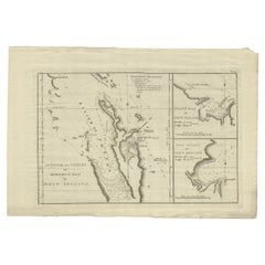
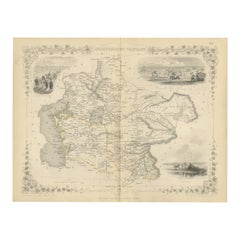
Map of New Zealand Showing Maori Culture and Early Colonial Settlements, 1851
About the Item
John Tallis & Company were renowned for their ornate and detailed maps in the mid-19th century. Their works often featured elaborate borders, decorative motifs, and insets of vignettes that illustrated significant landmarks, local peoples, and prominent flora and fauna associated with the region being depicted.
The map of New Zealand you've mentioned would have been created when New Zealand was a relatively new addition to the British Empire, with formal colonial control established in 1840 through the Treaty of Waitangi. It showcases both the North and South Islands, identifying key settlements, geographical features.
The insets and the main map itself in the Tallis series were designed not only for practical navigation but also to educate and enthrall the British public with the exotic appeal of their empire's distant lands. They are a mix of cartography, art, and imperial messaging, serving as historical records of how the British Empire wanted to be seen and understood during this era of expansion. These maps are treasured today for their historical value and artistic beauty.
The illustrations on the map would have been carefully chosen to depict the most recognizable aspects of New Zealand. This includes:
The images included as insets in the map are likely to be:
1. **A Maori Chief and Woman**: This medallion-style inset portrays a Māori chief and a woman in traditional attire, showcasing the indigenous peoples of New Zealand. Their clothing, facial tattoos (moko), and adornments are indicative of the rich cultural tapestry of the Māori.
2. **Wellington**: A view of Wellington, capturing its early development as a city. It may include the city's harbor, with colonial-era ships at anchor, surrounded by the rolling hills and rugged terrain that characterize the region.
3. **Mount Egmont from New Plymouth**: An illustration showing Mount Taranaki (also known as Mount Egmont) as seen from New Plymouth. The image might highlight the conical shape of the volcano, with a settlement in the foreground, indicating the European presence and their developing infrastructure.
4. **Auckland**: Depicts a coastal view of Auckland with its prominent volcanic hills in the background, and early colonial buildings and ships in the harbor, suggesting Auckland's importance as an early colonial and trade center.
These images not only provide geographical landmarks but also offer a cultural and societal perspective, emphasizing the dual narrative of natural beauty and colonial progress that was prevalent in the Tallis maps. They provide a snapshot into 19th-century life in New Zealand, reflecting both the Māori culture and the burgeoning colonial settlements.
- Dimensions:Height: 14.26 in (36.2 cm)Width: 10.71 in (27.2 cm)Depth: 0 in (0.02 mm)
- Materials and Techniques:
- Period:
- Date of Manufacture:1851
- Condition:Good given age. Original fold in middle as published. General age-related toning and soiling, please study scan carefully.
- Seller Location:Langweer, NL
- Reference Number:
About the Seller
5.0
Platinum Seller
These expertly vetted sellers are 1stDibs' most experienced sellers and are rated highest by our customers.
Established in 2009
1stDibs seller since 2017
1,928 sales on 1stDibs
Typical response time: <1 hour
- ShippingRetrieving quote...Ships From: Langweer, Netherlands
- Return PolicyA return for this item may be initiated within 14 days of delivery.
More From This SellerView All
- Detailed Map of New Zealand Showing the Route of Capt. Cook's First Voyage, 1803Located in Langweer, NLAntique map New Zealand titled 'De Rivier de Theems en Mercurius Baai in Nieuw Zeeland'. Detailed map of New Zealand showing the route of Capta...Category
Antique 19th Century Maps
MaterialsPaper
- Antique Map of New Zealand, 1895Located in Langweer, NLAntique map titled 'Neu-Seeland.' Map of New Zealand. With inset maps of the large cities. This attractive original old antique print / plate / map ...Category
Antique 19th Century Maps
MaterialsPaper
- Antique Map of Australia and New Zealand, c.1860Located in Langweer, NLAntique map titled 'Australia and New Zealand'. Unusual edition of this map of Australia and New Zealand, on very thin paper and multiple folding lines. Source unknown, to be determi...Category
Antique 19th Century Maps
MaterialsPaper
- Antique Map of New Zealand and Tasmania, 1904Located in Langweer, NLThis large antique map is taken from; 'Andrees Allgemeiner Handatlas in 126 Haupt-Und 139 Nebenkarten', Bielefeld; Leipzig: Velhagen & Klasing 1899. Andrees Allgemeiner Handatlas was...Category
20th Century Maps
MaterialsPaper
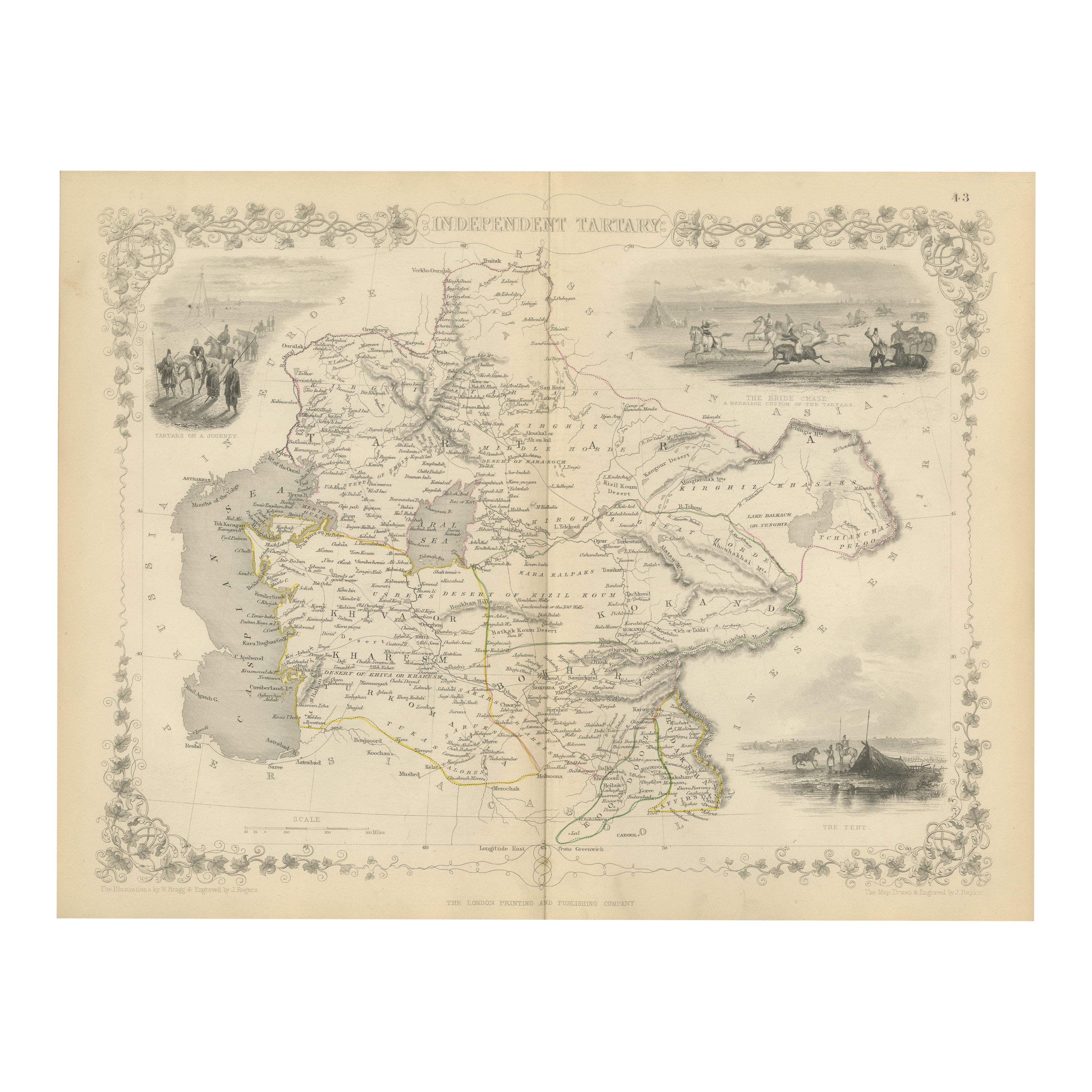
- Map of Independent Tartary with Vignettes of the Region's Culture, 1851Located in Langweer, NLThe map of Independent Tartary is part of the collection by John Tallis & Company, which were unique for their elaborate decorative elements and detailed illustrations. **The Maker ...Category
Antique 1850s Maps
MaterialsPaper
- Map of Tasmania with Illustrations of Local Fauna and Colonial Landmarks, 1851Located in Langweer, NLJohn Tallis & Company was renowned for their detailed and ornate maps during the 19th century. Their maps are distinguished by the intricate borders and vignettes that are as informa...Category
Antique 1850s Maps
MaterialsPaper
You May Also Like
- Large Original Vintage Map of New Zealand, South Island, circa 1920Located in St Annes, LancashireGreat map of South Island, New Zealand Original color. Good condition / repair to a minor tear on right edge Published by Alexander Gross Unframed.Category
Vintage 1920s English Edwardian Maps
MaterialsPaper
- 1851 Map of "Independent Tartary", Ric. R018Located in Norton, MA1851 Map of Independent Tartary "Russia" Ric.r018 A highly decorative 1851 map of Independent Tartary by John Tallis and John Rapkin. Covers the regions between the Caspian Sea and Lake Bakquash and between Russia and Afghanistan. These include the ancient Silk Route kingdoms of Khiva, Tartaria, Kokand, and Bokhara. Today this region roughly includes Kazakhstan, Uzbekistan, Turkmenistan, Kyrgyzstan, and Tajikistan. This wonderful map offers a wealth of detail for anyone with an interest in the Central Asian portion of the ancient Silk Road. Identifies various caravan routes, deserts, wells, and stopping points, including the cities of Bokhara and Samarkand. Three vignettes by W. Bragg decorate the map, these including an image of Tartars on a Journey, a horseback Bride Chase, and a tartar camp site. Surrounded by a vine motif border. Engraved by J. Rapkin for John Tallis's 1851 Illustrated Atlas . Tartary Antique Map...Category
Antique 19th Century Unknown Maps
MaterialsPaper
- "San Francisco, Upper California” 1851 Antique Map of San FranciscoLocated in Colorado Springs, COThis is a pictorial lettersheet view of the city and harbor of San Francisco. This lithograph was printed on grey wove paper, across a double sheet, by famed lithographers Britton & ...Category
Antique 1850s American Prints
MaterialsPaper
- Original Antique English County Map, Herefordshire, J & C Walker, 1851Located in St Annes, LancashireGreat map of Herefordshire Original colour By J & C Walker Published by Longman, Rees, Orme, Brown & Co. 1851 Unframed.Category
Antique 1850s English Other Maps
MaterialsPaper
- Original Antique English County Map, Rutland, J & C Walker, 1851Located in St Annes, LancashireGreat map of Rutland Original colour By J & C Walker Published by Longman, Rees, Orme, Brown & Co. 1851 Unframed.Category
Antique 1850s English Other Maps
MaterialsPaper
- Original Antique English County Map, Durham, J & C Walker, 1851Located in St Annes, LancashireGreat map of Durham Original colour By J & C Walker Published by Longman, Rees, Orme, Brown & Co. 1851 Unframed.Category
Antique 1850s English Other Maps
MaterialsPaper


