Items Similar to Map of Independent Tartary with Vignettes of the Region's Culture, 1851

Want more images or videos?
Request additional images or videos from the seller
1 of 6
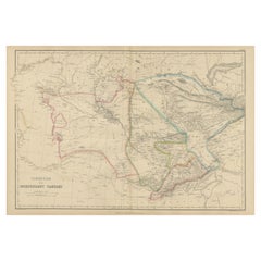
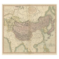
Map of Independent Tartary with Vignettes of the Region's Culture, 1851
About the Item
The map of Independent Tartary is part of the collection by John Tallis & Company, which were unique for their elaborate decorative elements and detailed illustrations.
**The Maker - John Tallis & Company:**
Known for the high level of detail and ornate borders, Tallis maps are works of art in the field of cartography. John Tallis, the founder, along with his company, are celebrated for their mid-19th-century maps that combined precise geographic detail with engaging artistic embellishments.
**The Map - Independent Tartary:**
"Independent Tartary" referred to the region of Central Asia that was not under the control of Russia or other major powers at the time. This would have included parts of what is now Turkmenistan, Kazakhstan, Tajikistan, Uzbekistan, and Kyrgyzstan. It was a region known for its nomadic cultures, significant trade routes like the Silk Road, and strategic geopolitical importance.
**The Countries and the Tallis Series:**
The regions depicted were historically home to various Turkic and Mongolic peoples, and the map would have been part of efforts to better understand the geography and political divisions of an area of considerable interest to the British Empire and other European powers.
The series "The British Colonies" by Robert Montgomery Martin aimed to provide detailed accounts of areas under British influence as well as those of interest to British explorers, traders, and diplomats. Though not a British colony, Independent Tartary would have been included due to its strategic importance.
**The Images on the Map:**
The vignettes and scenes in the Tallis maps serve to illustrate aspects of local life, culture, and geography, and they often include:
- Scenes of local people and their daily activities, such as traveling or hunting, depicted in the region’s vast and varied landscapes.
- Important landmarks or typical architecture of the region.
- Scenes of trade or transportation, reflecting the economic activities in the area.
These maps are a bridge between art and practical cartography, offering a window into the past perceptions and understandings of regions that were largely mysterious to the Western world at the time. They are prized by collectors today for their unique combination of accurate cartographic detail and artistic interpretation.
More details on the insets:
The insets on the map of Independent Tartary showcase various cultural and social aspects of the region:
1. **The Tent**: This inset likely illustrates the nomadic lifestyle of the peoples of the Central Asian steppes. The tent shown is a traditional yurt, which is portable and commonly used by nomadic tribes in the region.
2. **The Bride Chase**: Depicting a marriage custom of the Tartars, this scene shows horsemen and possibly a horse-drawn carriage involved in a ritual or celebration, which could involve the groom having to chase the bride on horseback as part of the matrimonial traditions.
3. **Tartars on a Journey**: This vignette presents a group of Tartars traveling, possibly depicting a caravan with loaded camels or horses, showing the nomadic nature of life on the steppes.
These insets were designed to give map readers a glimpse into the way of life and traditions of the people who lived in the vast region known as Independent Tartary, which spanned much of what is now Central Asia. The detailed artwork in these insets adds both charm and educational value to the map, reflecting the 19th-century European interest in exotic cultures and distant lands.
- Dimensions:Height: 10.71 in (27.2 cm)Width: 14.26 in (36.2 cm)Depth: 0 in (0.02 mm)
- Materials and Techniques:
- Period:
- Date of Manufacture:1851
- Condition:Good given age. Original fold in middle as published. General age-related toning, please study scan carefully.
- Seller Location:Langweer, NL
- Reference Number:Seller: BG-13736-61stDibs: LU3054339291832
About the Seller
5.0
Platinum Seller
These expertly vetted sellers are 1stDibs' most experienced sellers and are rated highest by our customers.
Established in 2009
1stDibs seller since 2017
1,928 sales on 1stDibs
Typical response time: <1 hour
- ShippingRetrieving quote...Ships From: Langweer, Netherlands
- Return PolicyA return for this item may be initiated within 14 days of delivery.
Auctions on 1stDibs
Our timed auctions are an opportunity to bid on extraordinary design. We do not charge a Buyer's Premium and shipping is facilitated by 1stDibs and/or the seller. Plus, all auction purchases are covered by our comprehensive Buyer Protection. Learn More
More From This SellerView All
- Antique Map of Independent Tartary by W. G. Blackie, 1859Located in Langweer, NLAntique map titled 'Turkestan or Independent Tartary'. Original antique map of Turkestan or Independent Tartary. This map originates from ‘The Imperial Atlas of Modern Geography’. Pu...Category
Antique Mid-19th Century Maps
MaterialsPaper
- Antique Map of Holland with Colorful Vignettes, 1851Located in Langweer, NLAntique map titled 'Holland'. Decorative map of Holland. Includes vignettes of Rotterdam, Dutch Peasants and a boating scene on the Dort, the Netherlands. Originates from 'Th...Category
Antique 19th Century Maps
MaterialsPaper
- Old Engraved Map of Hungary with Decorative Vignettes, 1851Located in Langweer, NLAntique map titled Hungary. Includes decorative vignettes titled Hungarian Peasants, Pesth and the Fortress of Buda, on the Danube and Hungarian Nobles. Originates from 'The Illustrated Atlas, And Modern History Of The World Geographical, Political, Commercial & Statistical, Edited By R. Montgomery Martin'. Published; John Tallis London, New York, Edinburgh & Dublin. 1851. Drawn and Engraved by J. Rapkin. Artists and Engravers: John Tallis (1817-1876) was a British map publisher. Born in the Midlands, Tallis came to London in the 1840s. Tallis began his London career with a series of remarkable London street views. He began a partnership with a Frederick Tallis, possibly his brother, but their collaboration ended in 1849. For the Great Exhibition of 1851, Tallis published the Illustrated World Atlas, one of the last series of decorative world maps ever produced. The maps were engraved by John Rapkin, a skilled artisan. The maps were later reissued by the London Printing & Publishing Company, who left the Tallis imprint intact, thus ensuring his enduring fame. In 1858, he began publication of the popular Illustrated News of the World...Category
Antique 19th Century Maps
MaterialsPaper
- Antique Map of Chinese and Independent Tartary, Korea and Japan, 1806Located in Langweer, NLAntique map titled 'A New Map of Chinese & Independent Tartary'. Beautiful map of Chinese Tartary, Korea and Japan. Artists and Engravers: John Cary (1755-1835) was a British car...Category
Antique 19th Century Maps
MaterialsPaper
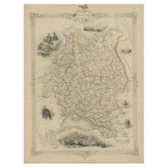
- Map of Russia with Vignettes of the Neoskoi Prospect, St. Petersburg, ca.1851Located in Langweer, NLAntique map titled 'Russia in Europe'. Map of European Russia. Showing vignettes of the Neoskoi Prospect, St. Petersburg, Polish Captives on their way to Siberia, a Russian Bear...Category
Antique 1850s Maps
MaterialsPaper
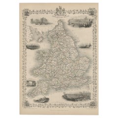
- Antique Map of England and Wales with Decorative Vignettes, 1851Located in Langweer, NLAntique map titled ‘England and Wales’. Includes decorative vignettes titled The grand stand on the race ground Doncaster, London, Oxford, Entrance to Portsmouth Harbour, Sunderland ...Category
Antique 19th Century Maps
MaterialsPaper

You May Also Like
- 1851 Map of "Independent Tartary", Ric. R018Located in Norton, MA1851 Map of Independent Tartary "Russia" Ric.r018 A highly decorative 1851 map of Independent Tartary by John Tallis and John Rapkin. Covers the regions between the Caspian Sea and Lake Bakquash and between Russia and Afghanistan. These include the ancient Silk Route kingdoms of Khiva, Tartaria, Kokand, and Bokhara. Today this region roughly includes Kazakhstan, Uzbekistan, Turkmenistan, Kyrgyzstan, and Tajikistan. This wonderful map offers a wealth of detail for anyone with an interest in the Central Asian portion of the ancient Silk Road. Identifies various caravan routes, deserts, wells, and stopping points, including the cities of Bokhara and Samarkand. Three vignettes by W. Bragg decorate the map, these including an image of Tartars on a Journey, a horseback Bride Chase, and a tartar camp site. Surrounded by a vine motif border. Engraved by J. Rapkin for John Tallis's 1851 Illustrated Atlas . Tartary Antique Map...Category
Antique 19th Century Unknown Maps
MaterialsPaper
- 1594 Maurice Bouguereau Map of the Region Limoges, France, Ric0015Located in Norton, MA1594 Maurice Bouguereau map of the region Limoges, France, entitled "Totivs Lemovici et Confinium Pro Uinciarum Quantum ad Dioecefin Lemo Uicenfen Fpectant," Hand Colored Ric0015 Jean IV Le Clerc...Category
Antique 16th Century Dutch Maps
MaterialsPaper
- "San Francisco, Upper California” 1851 Antique Map of San FranciscoLocated in Colorado Springs, COThis is a pictorial lettersheet view of the city and harbor of San Francisco. This lithograph was printed on grey wove paper, across a double sheet, by famed lithographers Britton & ...Category
Antique 1850s American Prints
MaterialsPaper
- The Normandy Region of France: A 17th C. Hand-colored Map by Sanson and JaillotBy Nicolas SansonLocated in Alamo, CAThis large hand-colored map entitled "Le Duché et Gouvernement de Normandie divisée en Haute et Basse Normandie en divers Pays; et par evêchez, avec le Gouvernement General du Havre ...Category
Antique 1690s French Maps
MaterialsPaper
- 17th Century Hand Colored Map of the Liege Region in Belgium by VisscherBy Nicolaes Visscher IILocated in Alamo, CAAn original 17th century map entitled "Leodiensis Episcopatus in omnes Subjacentes Provincias distincté divisusVisscher, Leodiensis Episcopatus" by Nicolaes Visscher II, published in Amsterdam in 1688. The map is centered on Liege, Belgium, includes the area between Antwerp, Turnhout, Roermond, Cologne, Trier and Dinant. This attractive map is presented in a cream-colored mat measuring 30" wide x 27.5" high. There is a central fold, as issued. There is minimal spotting in the upper margin and a tiny spot in the right lower margin, which are under the mat. The map is otherwise in excellent condition. The Visscher family were one of the great cartographic families of the 17th century. Begun by Claes Jansz Visscher...Category
Antique Late 17th Century Dutch Maps
MaterialsPaper
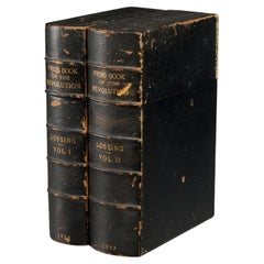
- The Pictorial Field-Book of the Revolution, 1851, (2) vols., Benson J. LossingBy S. Harper BrothersLocated in Morristown, NJ(2) vols., by Benson J. Lossing. ...Illustrations, by Pen and Pencil, of the History, Biography, Scenery, Relics, and Traditions of the War for Independence. Two volumes, the first i...Category
Antique 1850s American Victorian Books
MaterialsLeather, Paper