Items Similar to Beautiful Map of the Region Naters and Pancrasgors, The Netherlands, ca.1697


Want more images or videos?
Request additional images or videos from the seller
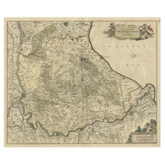
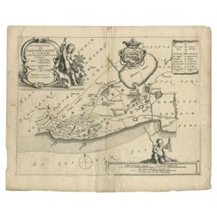
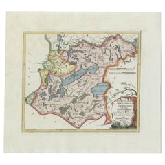
Beautiful Map of the Region Naters and Pancrasgors, The Netherlands, ca.1697
About the Item
Antique map titled ‘Caarte der Heerlyckheyt van Naters ende Pancras Gors’.
Beautiful map of the region Naters and Pancrasgors, The Netherlands. This map originates from ‘Caert-boeck Voorne’.
Artists and Engravers: A. Steyvaart, I. Stemmers and I. Luyken.
- Dimensions:Height: 20.08 in (51 cm)Width: 28.15 in (71.5 cm)Depth: 0.01 in (0.2 mm)
- Materials and Techniques:
- Period:1690-1699
- Date of Manufacture:circa 1697
- Condition:Repaired: repair on the right. Wear consistent with age and use. Condition: Good. General age-related toning. Repair on the right. Please study image carefully.
- Seller Location:Langweer, NL
- Reference Number:Seller: BG-06803 1stDibs: LU3054326763072
About the Seller
5.0
Platinum Seller
These expertly vetted sellers are 1stDibs' most experienced sellers and are rated highest by our customers.
Established in 2009
1stDibs seller since 2017
1,950 sales on 1stDibs
Typical response time: <1 hour
- ShippingRetrieving quote...Ships From: Langweer, Netherlands
- Return PolicyA return for this item may be initiated within 14 days of delivery.
Auctions on 1stDibs
Our timed auctions are an opportunity to bid on extraordinary design. We do not charge a Buyer's Premium and shipping is facilitated by 1stDibs and/or the seller. Plus, all auction purchases are covered by our comprehensive Buyer Protection. Learn More
More From This SellerView All
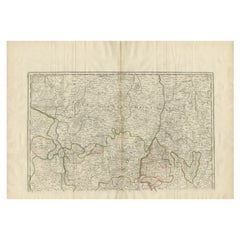
- Beautiful Map of Arnhem and the Veluwe Region, Gelderland, The Netherlands, 1690Located in Langweer, NLAntique map titled 'Ducatus Geldriae tetrachia Arnhemiensis sive Velavia'. Beautiful map of the region of Arnhem and the Veluwe region, Gelderland, the Netherlands. Artists an...Category
Antique 1690s Maps
MaterialsPaper
- Antique Map of the Region of Lyonnais by Nolin, 1697Located in Langweer, NLUntitled map of the French Province of Lyonnais, with its capital at Lyon, on the upper Loire and Rhone rivers. This map is a single sheet and part of a two sheet map titled 'The Gen...Category
Antique 17th Century Maps
MaterialsPaper
- Antique Map of the Old Land of Batavia and FriesLand, The Netherlands, 1697Located in Langweer, NLAntique map Friesland titled 'Descriptio veteris Agri Batavi et Frisii (..)'. Old map of Friesland, the Netherlands. Depicts the old land of Batavia and Friesland. This map originate...Category
Antique 17th Century Maps
MaterialsPaper
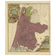
- Beautiful Antique Map of the Province of Noord-Holland, the Netherlands, Ca.1730Located in Langweer, NLAntique map titled 'Kennemaria et Westfrisia vulgo et vernaculé Noord-Holland'. Beautiful original antique map of the province of Noord-Holland, the Netherlands. Two large elaborat...Category
Antique 1730s Maps
MaterialsPaper
- Antique Map of the Region of Gaasterland, Friesland, The Netherlands, 1664Located in Langweer, NLAntique map titled 'De Grietenie van Gaesterlandt (..)'. Map of the region of Gaasterland in Friesland, the Netherlands. This region includes the villages of Balk, Sloten, Wyckel and...Category
Antique 17th Century Maps
MaterialsPaper
- Antique Map of the Region of Gaasterland, Friesland, The Netherlands, 1791Located in Langweer, NLAntique map titled 'Der Provinz Westergo zwey südliche Grietenyen mit dem Gaasterland und der Stadt Staveren, Sloten, Workum, Ylst und Hindelopen'. Map of the region of Gaasterland, ...Category
Antique 18th Century Maps
MaterialsPaper
You May Also Like
- 1752 Vaugoundy Map of Flanders : Belgium, France, and the Netherlands, Ric.a002Located in Norton, MALarge Vaugoundy Map of Flanders: Belgium, France, and the Netherlands Colored -1752 Ric.a002 Description: This is a 1752 Didier Robert de Vaugondy map of Flanders. The map de...Category
Antique 17th Century Unknown Maps
MaterialsPaper
- 1594 Maurice Bouguereau Map of the Region Limoges, France, Ric0015Located in Norton, MA1594 Maurice Bouguereau map of the region Limoges, France, entitled "Totivs Lemovici et Confinium Pro Uinciarum Quantum ad Dioecefin Lemo Uicenfen Fpectant," Hand Colored Ric0015 Jean IV Le Clerc...Category
Antique 16th Century Dutch Maps
MaterialsPaper
- The Normandy Region of France: A 17th C. Hand-colored Map by Sanson and JaillotBy Nicolas SansonLocated in Alamo, CAThis large hand-colored map entitled "Le Duché et Gouvernement de Normandie divisée en Haute et Basse Normandie en divers Pays; et par evêchez, avec le Gouvernement General du Havre ...Category
Antique 1690s French Maps
MaterialsPaper
- School Chart or Pull Down Map of Geography of the Netherlands, 1950sLocated in Hemiksem, VANA beautiful old school map of the Netherlands, painted on linen. The map shows the 3 different reliefs (low, middle, high) of the Netherlands. The beau...Category
Vintage 1950s Belgian Mid-Century Modern Maps
MaterialsLinen, Paint
- 17th Century Hand Colored Map of the Liege Region in Belgium by VisscherBy Nicolaes Visscher IILocated in Alamo, CAAn original 17th century map entitled "Leodiensis Episcopatus in omnes Subjacentes Provincias distincté divisusVisscher, Leodiensis Episcopatus" by Nicolaes Visscher II, published in Amsterdam in 1688. The map is centered on Liege, Belgium, includes the area between Antwerp, Turnhout, Roermond, Cologne, Trier and Dinant. This attractive map is presented in a cream-colored mat measuring 30" wide x 27.5" high. There is a central fold, as issued. There is minimal spotting in the upper margin and a tiny spot in the right lower margin, which are under the mat. The map is otherwise in excellent condition. The Visscher family were one of the great cartographic families of the 17th century. Begun by Claes Jansz Visscher...Category
Antique Late 17th Century Dutch Maps
MaterialsPaper
- Map of the Republic of GenoaLocated in New York, NYFramed antique hand-coloured map of the Republic of Genoa including the duchies of Mantua, Modena, and Parma. Europe, late 18th century. Dimension: 25...Category
Antique Late 18th Century European Maps


