Items Similar to Large Rhine River Map, Moselle and Meuse, by Willem Blaeu, Hand-coloured - 1640
Want more images or videos?
Request additional images or videos from the seller
1 of 10
Large Rhine River Map, Moselle and Meuse, by Willem Blaeu, Hand-coloured - 1640
$1,414.35
$1,767.9320% Off
£1,065.28
£1,331.6120% Off
€1,200
€1,50020% Off
CA$1,950.45
CA$2,438.0620% Off
A$2,191.24
A$2,739.0520% Off
CHF 1,144.93
CHF 1,431.1620% Off
MX$26,745.09
MX$33,431.3620% Off
NOK 14,537.21
NOK 18,171.5120% Off
SEK 13,683.72
SEK 17,104.6520% Off
DKK 9,133.94
DKK 11,417.4320% Off
About the Item
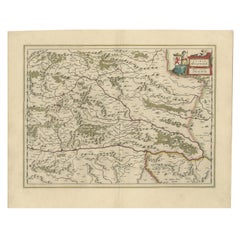
Rhine River & Tributaries Antique Map by Willem Blaeu, c.1640
This spectacular mid-seventeenth-century copper-engraved map, titled in Latin “Rhenus Fluviorum Europae celeberrimus, cum Mosa, Mosella, et reliquis, in illum se exonerantibus, fluminibus,” traces the full sweep of the Rhine from its Alpine headwaters near Chur and Lake Constance, down past Basel, Strasbourg, Speyer, Worms, Mainz, Koblenz, Bonn, Cologne, Düsseldorf and Utrecht to its many mouths on the North Sea.
Alongside the main stream appear its great tributaries—the winding Mosel / Moselle, the romantic Neckar, the navigable Main, the Lahn and Ruhr, plus the adjacent Meuse / Maas—offering an almost encyclopaedic survey of western Germany, eastern France, Switzerland, the Rhineland-Palatinate, Baden-Württemberg, Alsace, the Netherlands and adjoining Low Countries. Hills are rendered in delicate hachures, forests in leafy clusters, and scores of fortified towns, castles and abbeys are neatly lettered, making the sheet both a work of art and a valuable historical document.
Cartographer Willem Janszoon Blaeu, the eminent Amsterdam publisher whose workshop defined the Golden Age of Dutch cartography, first issued this plate circa 1640; the present example is an early hand-coloured impression with vibrant original wash.
Orientation is intriguingly rotated, with north at the right margin, a design choice that allows the complete river system to unfurl naturally across the landscape.
Visual drama abounds: a grand dedication cartouche to Amsterdam burgomaster Andreae Bickero is supported by an armoured warrior and a river nymph; at lower left Bacchus and reclining river gods celebrate the fertility of the Rhine valley, watched by woodland animals; along the top margin a parade of putti bear the coats-of-arms of principal provinces—Swabia, Franconia, Bavaria, Alsatia, Helvetia, Geldria and others—creating an elegant heraldic frieze. Such lively allegory, combined with precise hydrography and political boundary colouring, makes this map irresistible to collectors of Blaeu, Rhine River memorabilia, German history, Dutch Golden Age prints, wine-region ephemera and university libraries seeking a teaching exemplar.
Condition report
• Strong, clean impression on lightly toned, sturdy laid paper
• Original centre-fold as issued; faint reinforcement on verso at two tiny separations
• Contemporary hand colour, still bright, with only the gentlest rubbing at extreme sheet edges
• Ample margins all round (approx. 10–15 mm), untrimmed; a few marginal finger-marks and one discreet archival tape guard, none affecting the engraved area
• No foxing, tears or repairs within the image; overall very good collector’s condition for a 380-year-old map
Framing tip summary
Pair the warm, earthy palette of the hand colouring with an off-white or pale ivory acid-free mount and a medium-toned walnut or subtle ebonised fruitwood frame; add a narrow gilt slip if you wish to echo the map’s baroque cartouches. Use UV-filtering museum glass and a sealed, acid-free backing to preserve the pigments and laid paper texture for decades of display.
- Dimensions:Height: 16.93 in (43 cm)Width: 38.98 in (99 cm)Depth: 0.02 in (0.5 mm)
- Materials and Techniques:Paper,Engraved
- Place of Origin:
- Period:Mid-17th Century
- Date of Manufacture:circa 1640
- Condition:Repaired: Repair on folding line. Original/contemporary hand coloring. Two sheets joined together, original folding lines (repaired). General age-related toning. Minor wear, blank verso. Please study images carefully.
- Seller Location:Langweer, NL
- Reference Number:Seller: BG-124981stDibs: LU3054320107192
About the Seller
5.0
Recognized Seller
These prestigious sellers are industry leaders and represent the highest echelon for item quality and design.
Platinum Seller
Premium sellers with a 4.7+ rating and 24-hour response times
Established in 2009
1stDibs seller since 2017
2,534 sales on 1stDibs
Typical response time: <1 hour
- ShippingRetrieving quote...Shipping from: Langweer, Netherlands
- Return Policy
Authenticity Guarantee
In the unlikely event there’s an issue with an item’s authenticity, contact us within 1 year for a full refund. DetailsMoney-Back Guarantee
If your item is not as described, is damaged in transit, or does not arrive, contact us within 7 days for a full refund. Details24-Hour Cancellation
You have a 24-hour grace period in which to reconsider your purchase, with no questions asked.Vetted Professional Sellers
Our world-class sellers must adhere to strict standards for service and quality, maintaining the integrity of our listings.Price-Match Guarantee
If you find that a seller listed the same item for a lower price elsewhere, we’ll match it.Trusted Global Delivery
Our best-in-class carrier network provides specialized shipping options worldwide, including custom delivery.More From This Seller
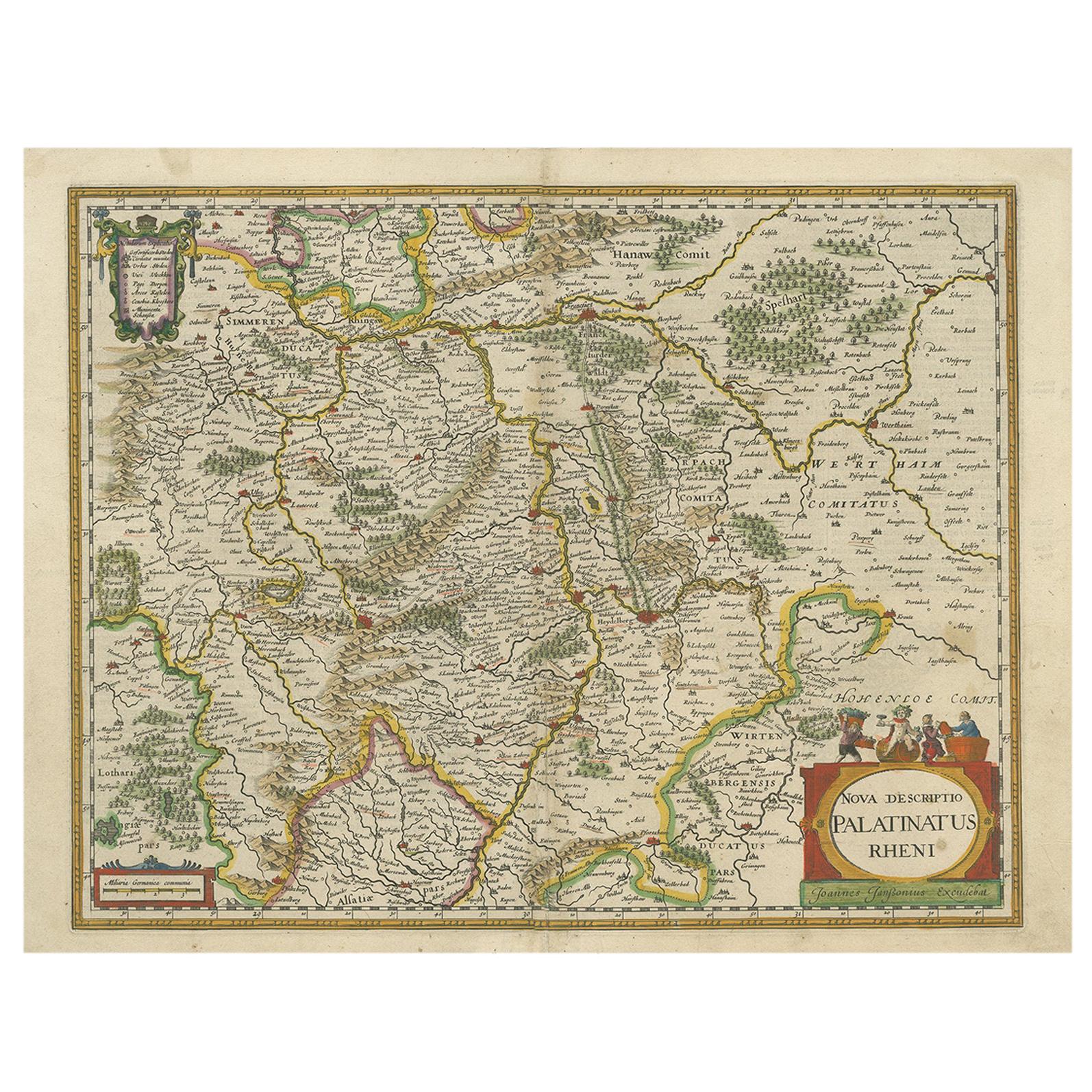
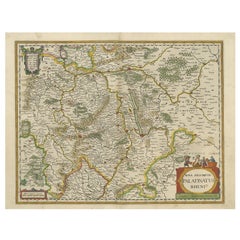
View AllAntique Map of the Rhine-Palatinate by Janssonius, circa 1630
Located in Langweer, NL
Antique map titled 'Nova Descriptio Palatinatus Rheni'. Detailed map of the Rhine-Palatinate, a state of Germany located in the west of the country. The map tracks the course of the ...
Category
Antique Mid-17th Century Maps
Materials
Paper
$471 Sale Price
20% Off
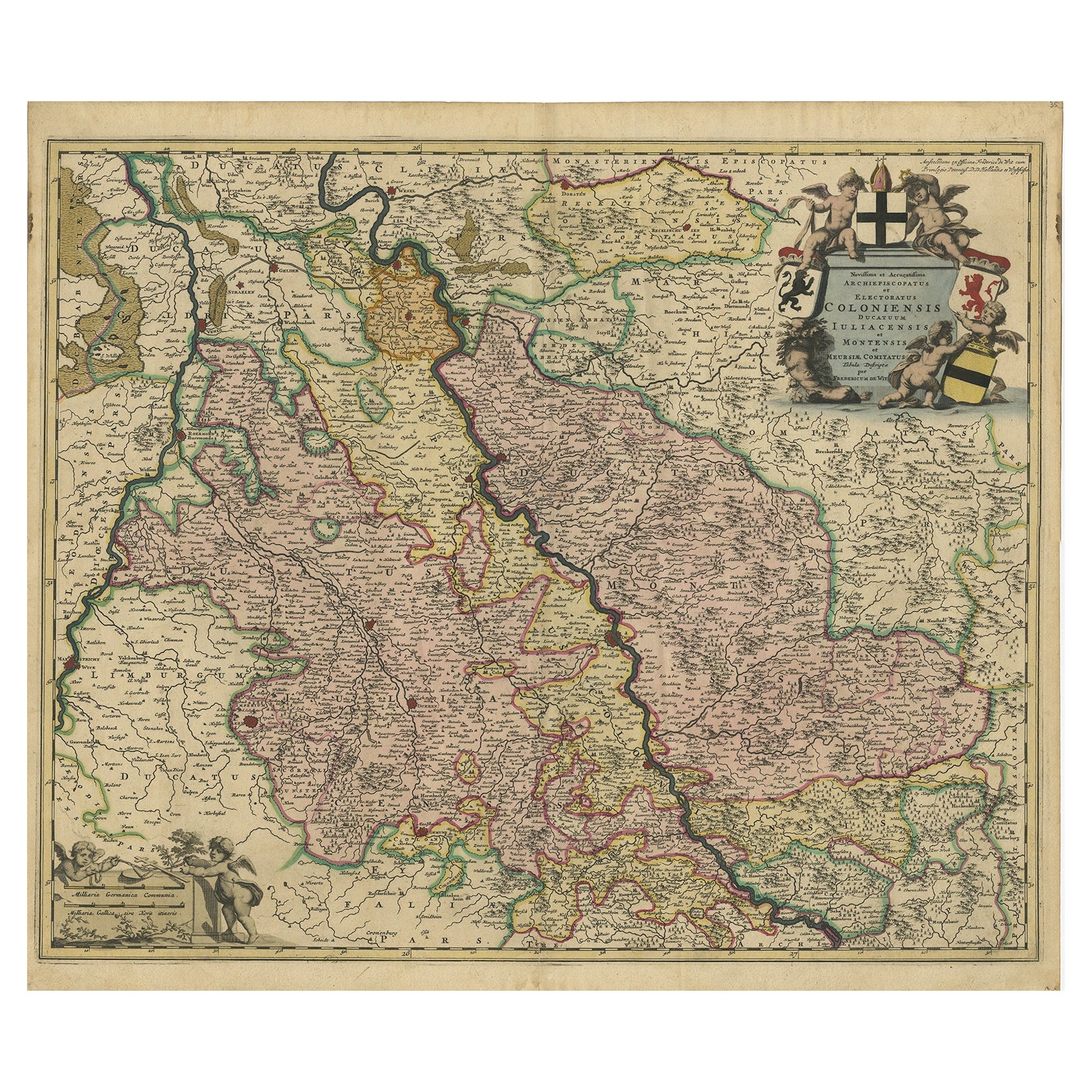
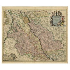
Rhine Splendor: Antique Map of the Lower Rhine Region, circa 1680
Located in Langweer, NL
The antique map titled 'Novissima et Accuratissima Archiepiscopatus et Electoratus Coloniensis Ducatuum Iuliancensis et Montensis et Meursiae Comitatus' is a handsome and detailed ma...
Category
Antique 1680s Maps
Materials
Paper
$905 Sale Price
20% Off
Free Shipping
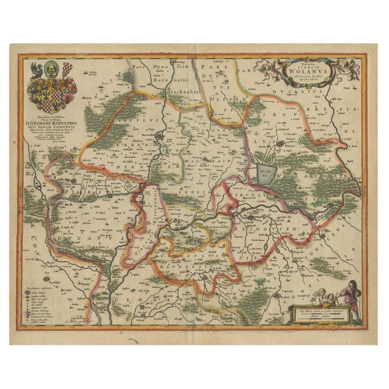
Antique Map of Lower Silesia of The Famous Mapmaker Blaeu, c.1650
Located in Langweer, NL
Antique map titled 'Ducatus Silesiae Wolanus'. \
Antique map depicting lower Silesia with the cities of Wolow (Wohlau), Winsko (Winzig), Herrnstadt, Chobie (Koben), Lubin (Lüben), R...
Category
Antique 17th Century Maps
Materials
Paper

$801 Sale Price
20% Off
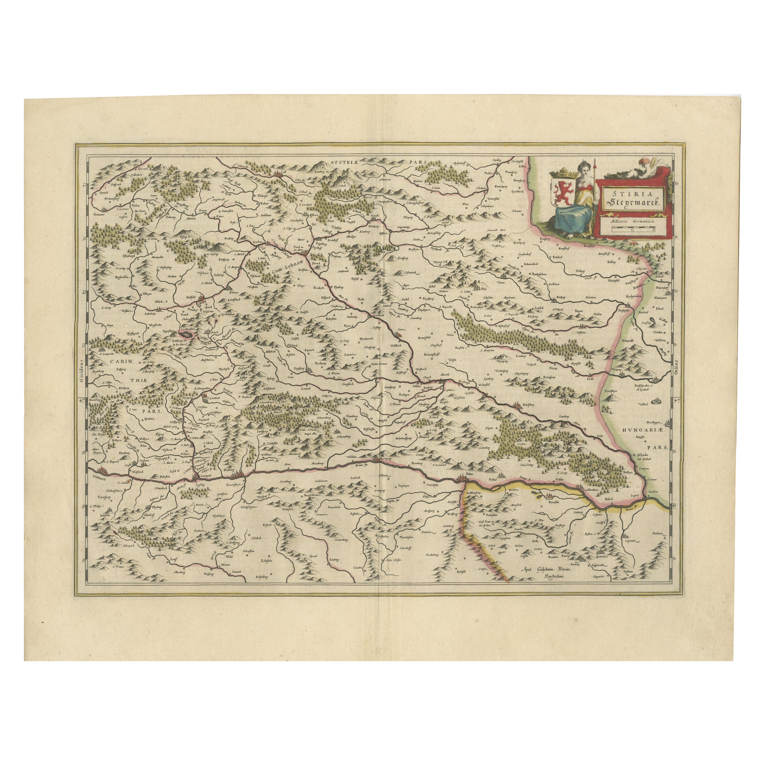
Map of Styria by William Blaeu, 1645: A Masterpiece of 17th-Century Cartography
Located in Langweer, NL
This 1645 map, created by Willem Janszoon Blaeu, represents Styria (Steyrmark), a historical region in present-day Austria, located in the Alpine regions. Blaeu, one of the most sign...
Category
Antique 1640s Maps
Materials
Paper
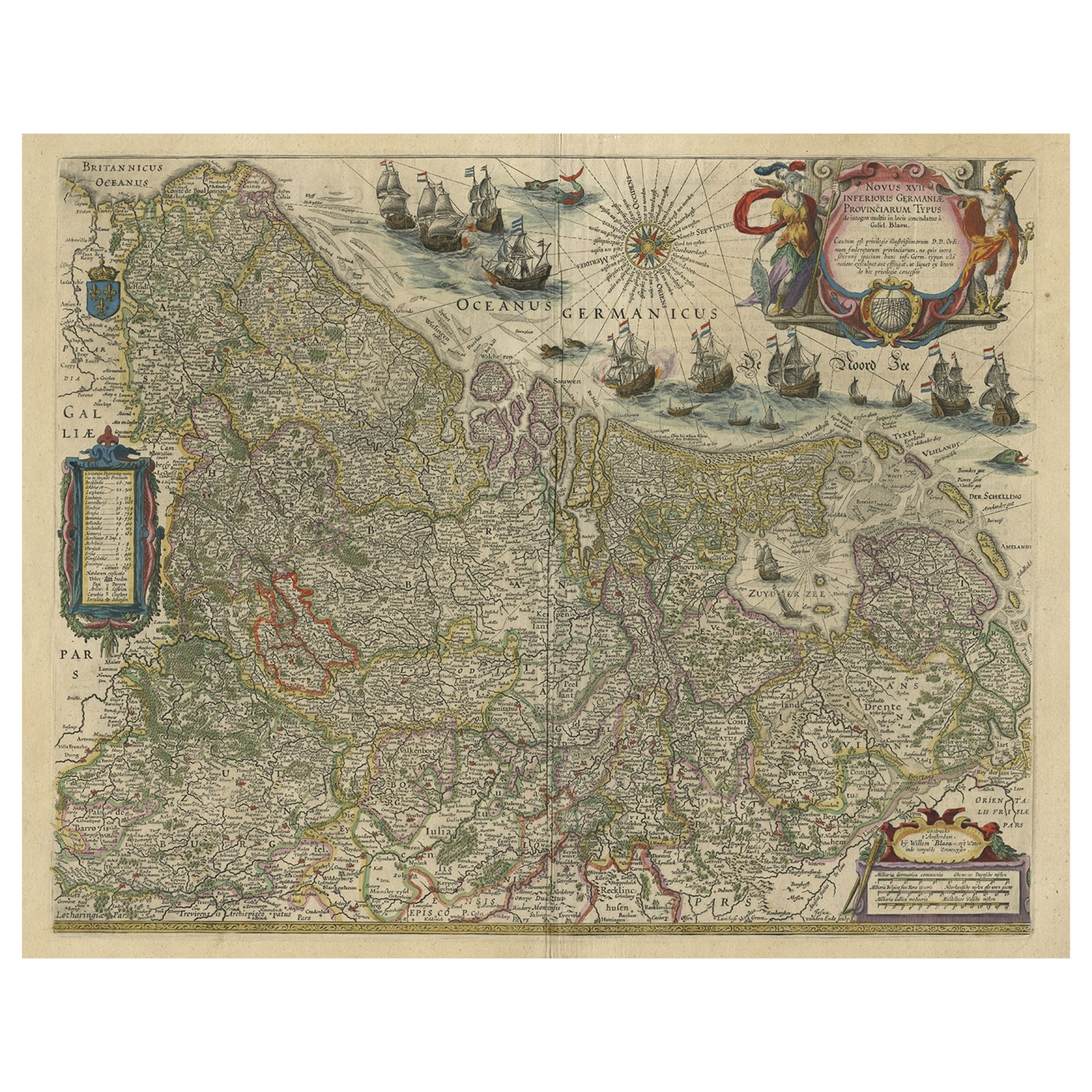
Handsome Old Detailed Map of the Low Countries by Famous Mapmaker Blaeu, ca.1635
Located in Langweer, NL
Antique map titled 'Novus XVII Inferioris Germaniae Provinciarum Typus'.
Handsome - and much sought after- detailed map of the Low Countries by the world most famous map maker Bla...
Category
Antique 1630s Maps
Materials
Paper
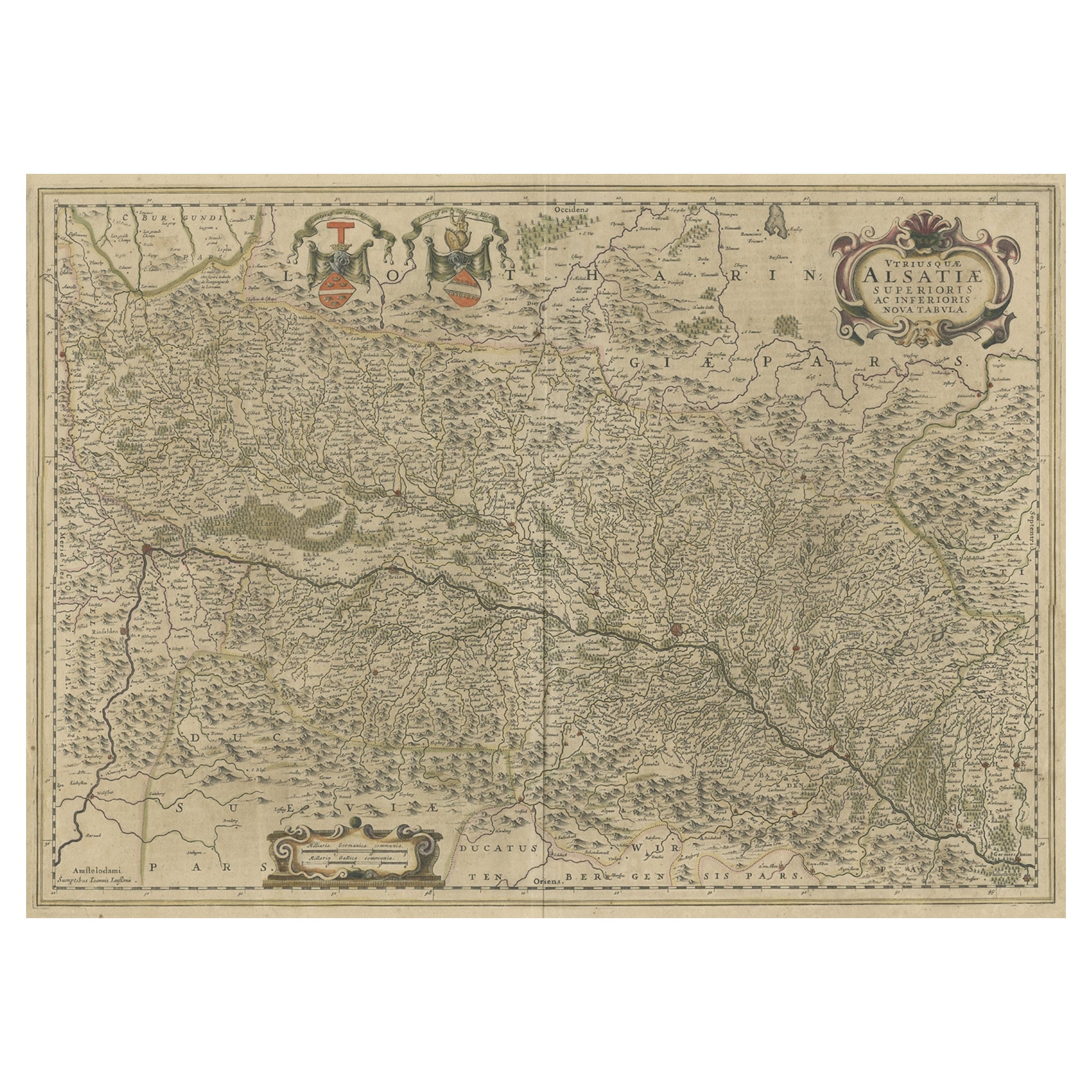
Map of the Alsace, France Incl the Rhine from Phillipsburg to South Basle, c1650
Located in Langweer, NL
Antique map titled 'Utriusquae Alsatiae Superioris Ac Inferioris Nova Tabula'.
Map of the Alsace region (France) including the Rhine from Phillipsburg to south of Basle. Two deco...
Category
Antique 1650s Maps
Materials
Paper

$339 Sale Price
20% Off
You May Also Like
1640 Willem Blaeu Map Entitled "Contado di molise et principato vltra, " Ric.a003
By Willem Blaeu
Located in Norton, MA
1640 Willem Blaeu map entitled
"Contado di molise et principato vltra,"
Colored
Ric. a003
Measures: 38 x 49.6 cm and wide margins
DBLAEU.
Cou...
Category
Antique 17th Century Dutch Maps
Materials
Paper

1640 Joan Bleau Map Entitled"Diocecese de rheims et le pais de rethel, " Eic.a011
Located in Norton, MA
1640 Joan Bleau map entitled
"Diocecese de rheims et le pais de rethel,"
Ric.a011
OAN BLAEU
Diocecese de Rheims, et le pais de Rethel.
Handcolored engraving, c.1640.
...
Category
Antique 17th Century Dutch Maps
Materials
Paper

1620 Map of Artois Entitled "Artesia Comitatvs Artois, " by Bleau, Ric.a012
Located in Norton, MA
1640 map of Artois entitled
"Artesia Comitatvs Artois,"
by Bleau
Colored
A-012.
Detailed map of the northern province of Artois, France on the border with Belgium. Feature...
Category
Antique 17th Century Dutch Maps
Materials
Paper

1635 Willem Blaeu Map of Northern France"Comitatvs Bellovacvm" Ric.a08
Located in Norton, MA
1635 Willem Blaeu map of northern France, entitled.
"Comitatvs Bellovacvm Vernacule Beavvais,"
Colored
Ric.a008
“COMITATVS BELLOVACVM…” Amsterdam: W...
Category
Antique 17th Century Unknown Maps
Materials
Paper

Antique Map Of Brabantia Ducantus By Bleau Circa 1640
Located in Brussels, Brussels
map of theBrabantia Ducantus (Belgium) circa 1640 by Bléau. Bléau was well known for antique atlas that he draw during the 17 century
beautiful map, double page folded in the middle,...
Category
Antique 17th Century French Renaissance Maps
Materials
Paper

1571-1638 Willem Blaeu map entitled, "Ilcadorino, " Hand Colored Ric0009
Located in Norton, MA
Willem Blaeu map entitled,
"Ilcadorino,".
Hand colored.
Description: large, unusual, and nice antique copper engraved map of Ilcadorino, by Willem BL...
Category
Antique 16th Century Dutch Maps
Materials
Paper

More Ways To Browse
Antique Ivory Collectables
Baroque Cartouche
Swiss Antiques And Collectables
Blaeu Maps
French Wine Map
Wine 17th
Antique Wine Maps
Large Framed Maps
Swiss Guard
Swiss Recliners
Antique Map Of Switzerland
17th Century Watch
Mid Century Recliner Walnut
17th Century Wine Glasses
Antique Great Lakes Map
Rotating Library
Library Recliners
Wine Filter