Items Similar to Original Old Copper Engraved Map of the Region of Albi, Southern France, 1663

Want more images or videos?
Request additional images or videos from the seller
1 of 5
Original Old Copper Engraved Map of the Region of Albi, Southern France, 1663
$527.64
$659.5520% Off
£392.51
£490.6420% Off
€440
€55020% Off
CA$722.52
CA$903.1520% Off
A$803.34
A$1,004.1820% Off
CHF 419.46
CHF 524.3320% Off
MX$9,778.62
MX$12,223.2820% Off
NOK 5,352.14
NOK 6,690.1720% Off
SEK 5,014.69
SEK 6,268.3720% Off
DKK 3,349.48
DKK 4,186.8520% Off
Shipping
Retrieving quote...The 1stDibs Promise:
Authenticity Guarantee,
Money-Back Guarantee,
24-Hour Cancellation
About the Item
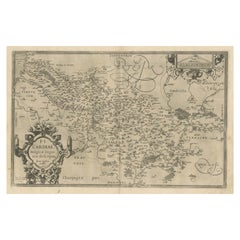
Antique map titled 'Carte du Diocese d'Alby'.
Original antique map of the region of Albi in Southern France. This map originates from 'Topographia Galliae dat is eene algemeene en bysondere naukeurige lant en plaets beschrivinge (..)' published 1663.
Artists and Engravers: Caspar Merian (1627-1686) was one of the most important German topographical engravers and publishers in the Baroque period. He was the son and pupil of his father Matthaeus Merian the elder (1593-1650) and his first wife Maria Magdalena - de Bry. His brother was Matthaeus the younger. The artist Maria Sibylla Merian (1647-1717) was his half sister from his fathers second wife Johanna Sibylla Catharina.
Condition: Good, general age-related toning. Original folding line, minor wear. Blank verso. Please study image carefully.
- Dimensions:Height: 12.6 in (32 cm)Width: 15.16 in (38.5 cm)Depth: 0 in (0.02 mm)
- Materials and Techniques:
- Period:1660-1669
- Date of Manufacture:1663
- Condition:
- Seller Location:Langweer, NL
- Reference Number:Seller: BG-12834-3 1stDibs: LU3054326653092
About the Seller
5.0
Recognized Seller
These prestigious sellers are industry leaders and represent the highest echelon for item quality and design.
Platinum Seller
Premium sellers with a 4.7+ rating and 24-hour response times
Established in 2009
1stDibs seller since 2017
2,511 sales on 1stDibs
Typical response time: <1 hour
- ShippingRetrieving quote...Shipping from: Langweer, Netherlands
- Return Policy
Authenticity Guarantee
In the unlikely event there’s an issue with an item’s authenticity, contact us within 1 year for a full refund. DetailsMoney-Back Guarantee
If your item is not as described, is damaged in transit, or does not arrive, contact us within 7 days for a full refund. Details24-Hour Cancellation
You have a 24-hour grace period in which to reconsider your purchase, with no questions asked.Vetted Professional Sellers
Our world-class sellers must adhere to strict standards for service and quality, maintaining the integrity of our listings.Price-Match Guarantee
If you find that a seller listed the same item for a lower price elsewhere, we’ll match it.Trusted Global Delivery
Our best-in-class carrier network provides specialized shipping options worldwide, including custom delivery.More From This Seller
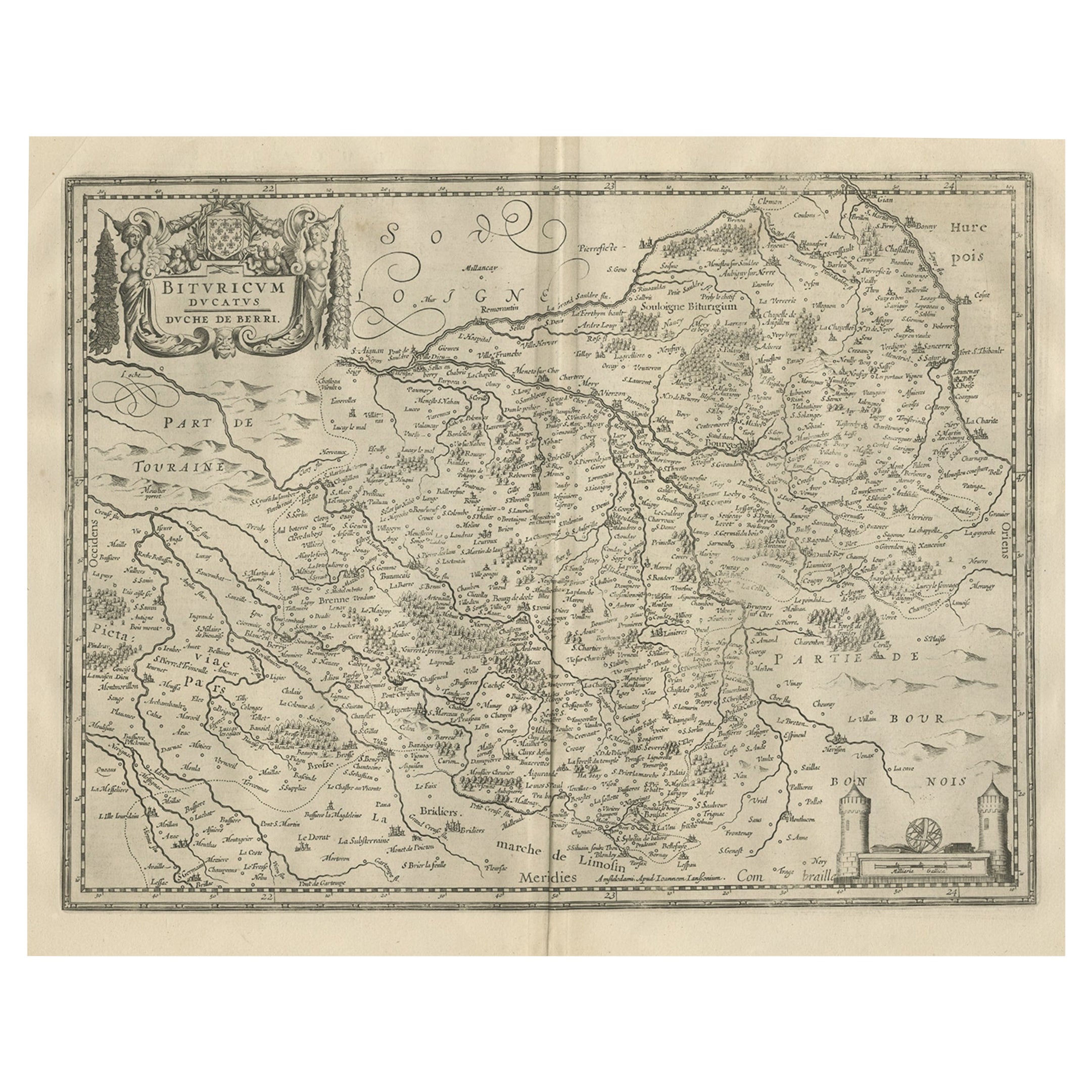
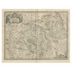
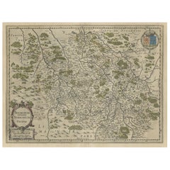
View AllDecorative Antique Map of the Berry Region, France, 1657
Located in Langweer, NL
Antique map of France titled 'Bituricum Ducatus - Duche de Berri'.
Decorative map of the Berry region, France. Berry is a region located in the center of France. It was a provinc...
Category
Antique 1650s Maps
Materials
Paper
$537 Sale Price
20% Off
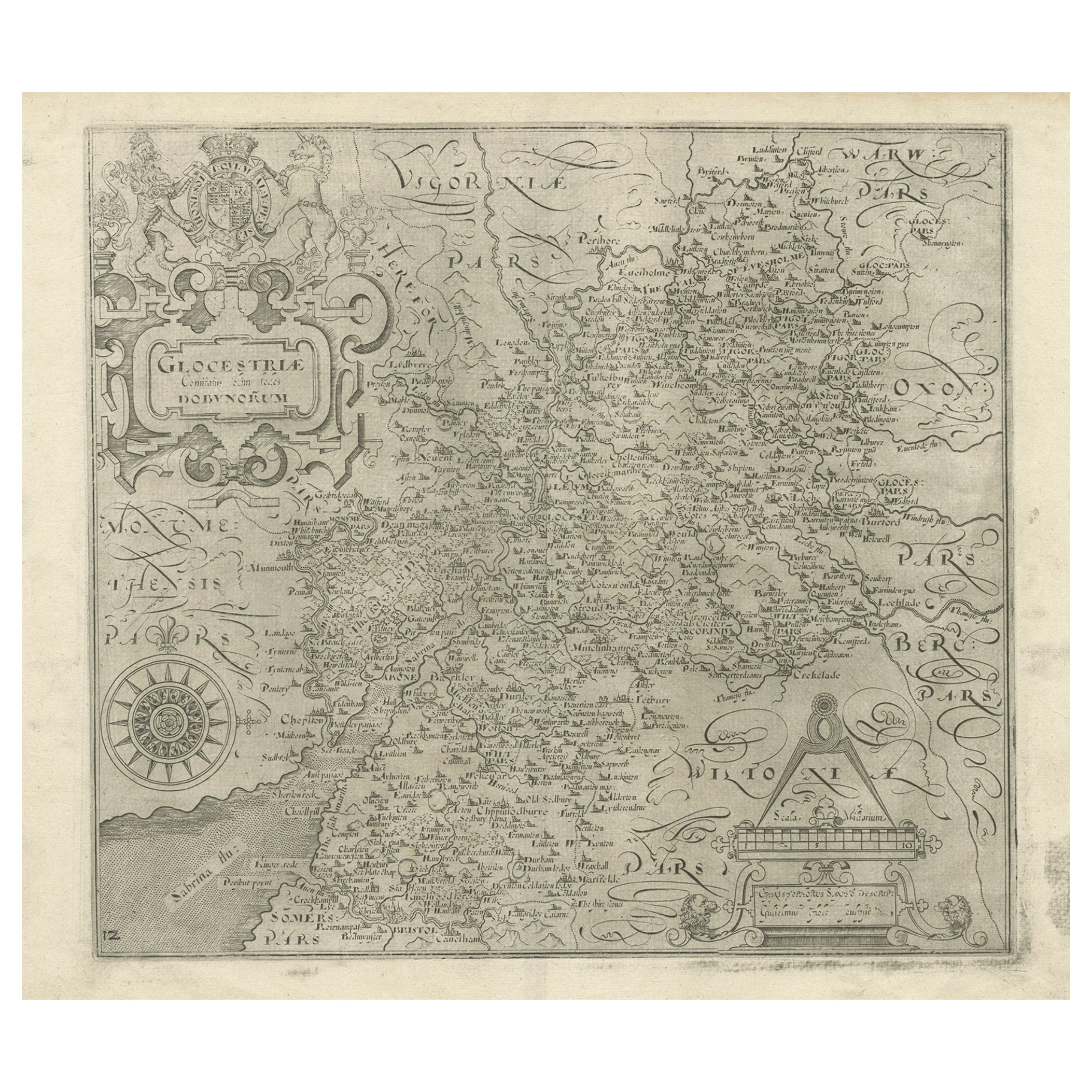
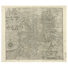
Antique Copper Engraved Map of Gloucestershire in England, 1637
Located in Langweer, NL
Antique map titled 'Glocestriae comitatus olim sedes Dobunorum'. Map of Gloucestershire, England. This map originates from Camden?s 'Britannia' ...
Category
Antique 17th Century Maps
Materials
Paper
$335 Sale Price
20% Off
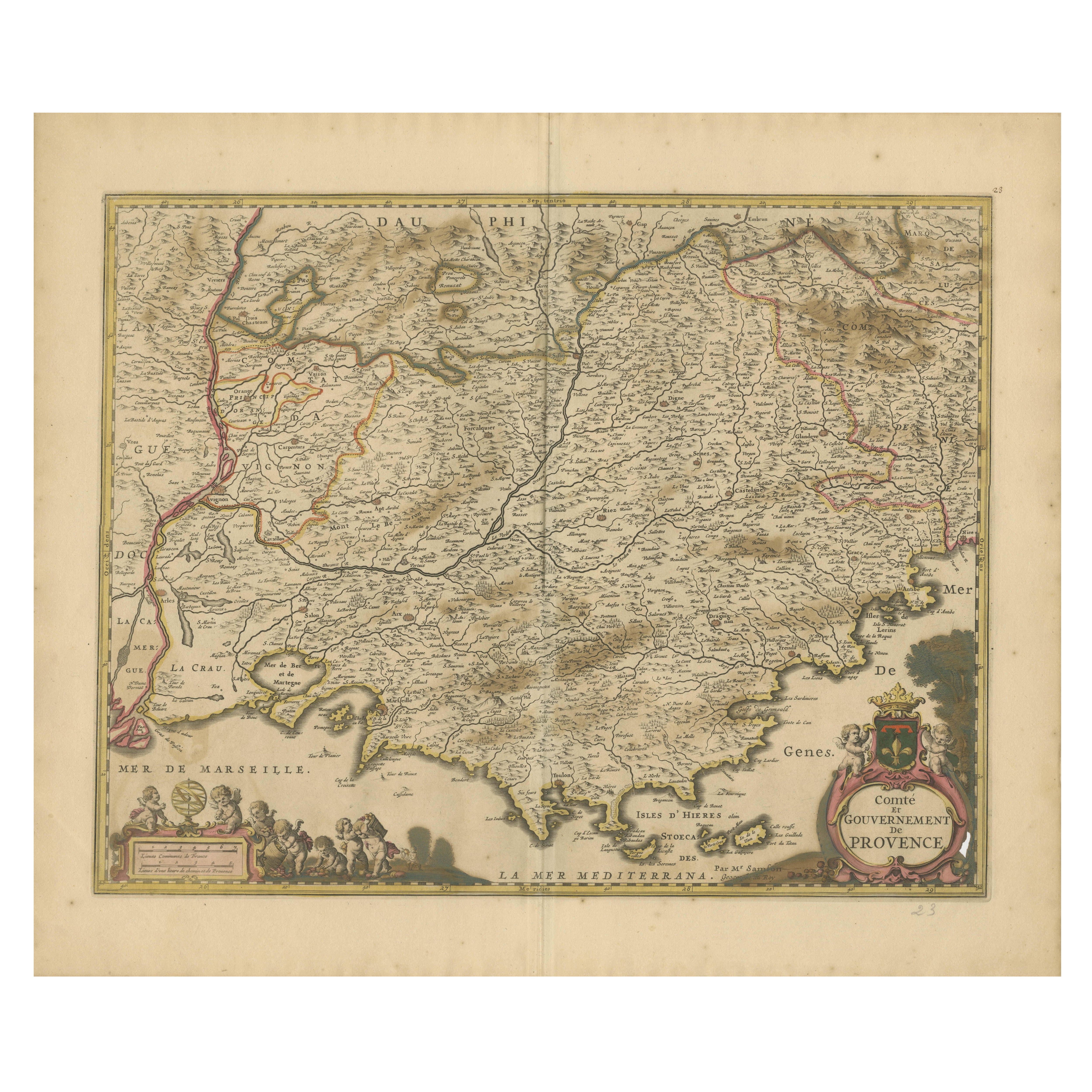
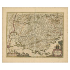
Map of the Provence in Southern France, Original Old Engraving by De Wit c. 1688
Located in Langweer, NL
Title: Provence Map - Hand-Colored 17th-Century Engraving by Frederik De Wit c. 1688
Description: This captivating map, "Gouvernement de Provence," depicts the Provence region of so...
Category
Antique 1680s Maps
Materials
Paper
Antique Map of the Region of Lyon by Hondius, circa 1630
Located in Langweer, NL
Antique map titled 'Lionnois, Forest et Beauiolois'. Old map of the former region of Lyon, Vienne, Bresse, Rohan and the Rhône River. This map originates f...
Category
Antique Mid-17th Century Maps
Materials
Paper

$479 Sale Price
20% Off
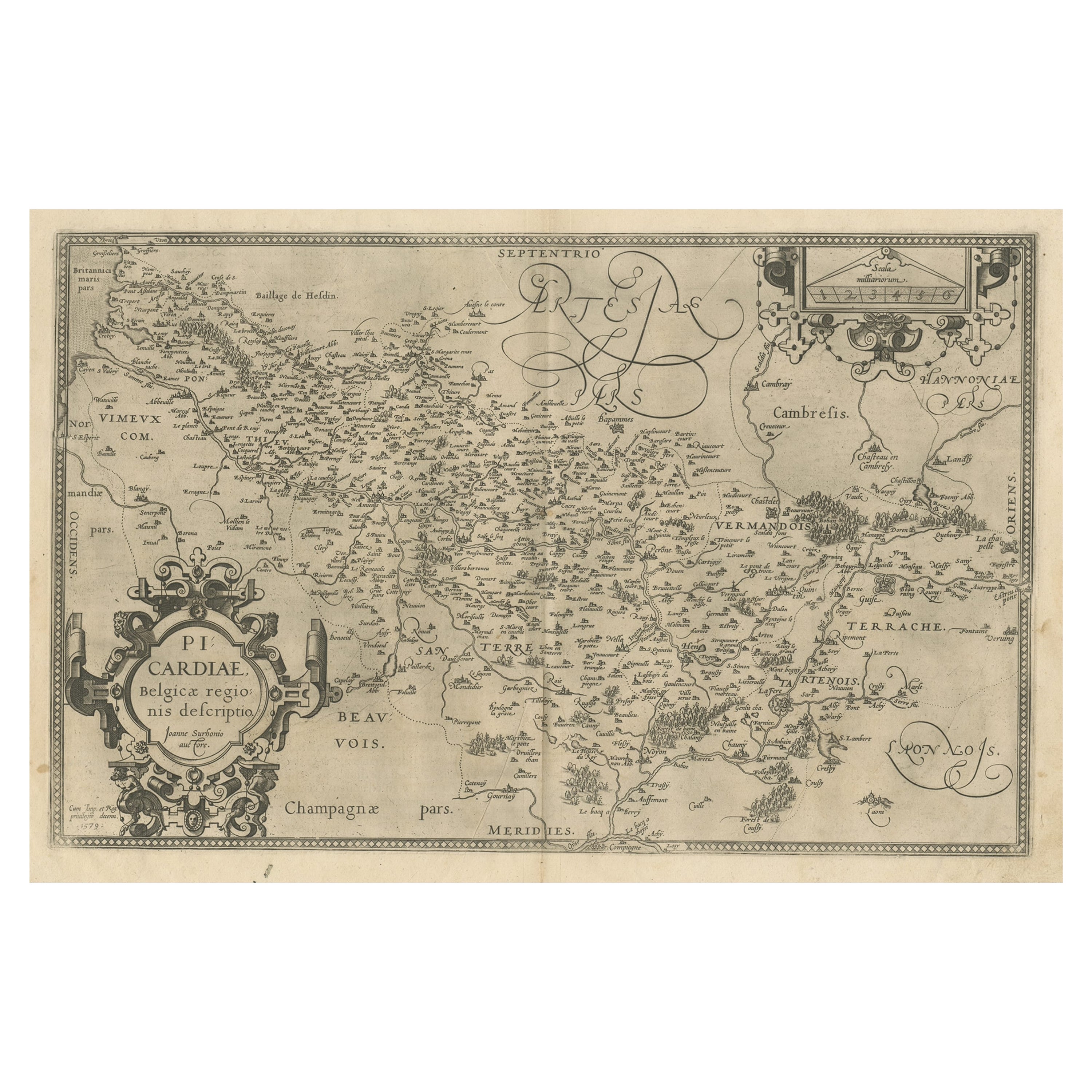
Original Antique Map of the Region of Picardy, France, ca.1602
Located in Langweer, NL
Antique map titled 'Picardiae Belgicae regionis descriptio'.
Original antique map of the region of Picardy, France. Superb example of the decorative style of Ortelius and filled ...
Category
Antique Early 1600s Maps
Materials
Paper
$623 Sale Price
20% Off
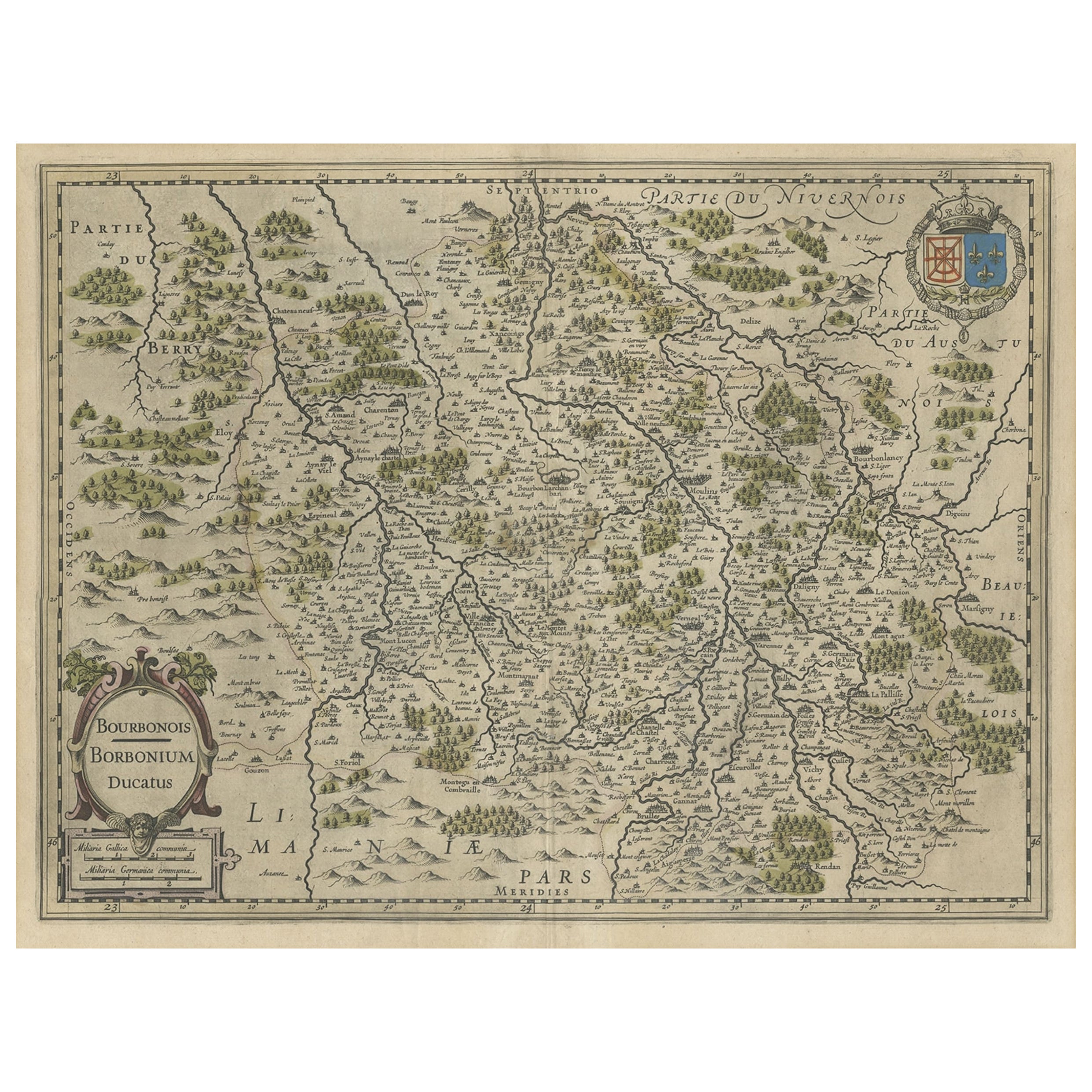
Old Map of the Bourbonnais Region of France, ca.1630
Located in Langweer, NL
Antique map titled 'Bourbonois - Borbonium Ducatus'.
Old map of the Bourbonnais region of France. Bourbonnais was a historic province in the centre of France that corresponds to ...
Category
Antique 1630s Maps
Materials
Paper
$604 Sale Price
20% Off
You May Also Like
1625 Mercator Map of the Provenience of Quercy, "Quercy Cadvrcivm Ric.0013
Located in Norton, MA
1625 Mercator map of the provenience of Quercy, entitled
"Quercy Cadvrcivm,"
Ric.0013
" Authentic" - Map of the provenience of Quercy Cadvrcivm
D...
Category
Antique 17th Century French Maps
Materials
Paper

1640 Joan Bleau Map Entitled"Diocecese de rheims et le pais de rethel, " Eic.a011
Located in Norton, MA
1640 Joan Bleau map entitled
"Diocecese de rheims et le pais de rethel,"
Ric.a011
OAN BLAEU
Diocecese de Rheims, et le pais de Rethel.
Handcolored engraving, c.1640.
...
Category
Antique 17th Century Dutch Maps
Materials
Paper

1635 Willem Blaeu Map of Northern France"Comitatvs Bellovacvm" Ric.a08
Located in Norton, MA
1635 Willem Blaeu map of northern France, entitled.
"Comitatvs Bellovacvm Vernacule Beavvais,"
Colored
Ric.a008
“COMITATVS BELLOVACVM…” Amsterdam: W...
Category
Antique 17th Century Unknown Maps
Materials
Paper

1656 Jansson Map Metz Region of France Entitled "Territorium Metense" Ric0014
Located in Norton, MA
1656 Jansson map Metz Region of France entitled "Territorium Metense."
Ric0014
" Authentic" - Map of the historical region surrounding Metz, in Lorraine, France.
Oriented with ...
Category
Antique 17th Century Dutch Maps
Materials
Paper

1771 Bonne Map of Poitou, Touraine and Anjou, France, Ric.a015
Located in Norton, MA
1771 Bonne Map of Poitou,
Touraine and Anjou, France
Ric.a015
1771 Bonne map of Potiou, Touraine and Anjou entitled "Carte des Gouvernements D'Anjou et du Saumurois, de la Touraine, du Poitou,du Pays d'aunis, Saintonge?Angoumois,"
Carte des gouvernements d'Anjou et du Saumurois, de la Touraine, du Poitou, du Pays d'Aunis, Saintonge-Angoumois. Projettee et assujettie au ciel par M. Bonne, Hyd. du Roi. A Paris, Chez Lattre, rue St. Jacques a la Ville de Bord(ea)ux. Avec priv. du Roi. 1771. Arrivet inv. & sculp., Atlas moderne ou collection de cartes sur toutes...
Category
Antique 17th Century Unknown Maps
Materials
Paper

17th Century Topographical Map of Cote D'azur, Avignon, Frejus by Iohan Peeters
Located in New York, NY
Fine topographical 17th century map by Iohan Peeters of the towns of Avignon and Frejus in the Cote d'Azur-Provence-Alpes Region of Southeastern France.
Beautifully suited decorativ...
Category
Antique 17th Century Dutch Maps
Materials
Paper

More Ways To Browse
Sri Lanka Map
Philippines Map
Antique Map Ceylon
Antique Sri Lanka Map
Persian Maps
Antique Civil War Maps
Antique Map Of The Philippines
Large Map Of Italy
Used Marine Compass
West Indies Colonial
Antique Pamphlets
Sicily Map
Thailand Map
Antique Maps Of Russian Empire
Antique Navigational Tools
Australian Colonial
Antique German Compass
Key Trade Sign