18th Century More Furniture and Collectibles

to
1,881
2,623
610
3,265
158
135
57
49
49
46
38
26
13
5
2
2
1
1
1
5,285
10,610
31,723
15,224
6,684
13,761
6,701
930
566
1,134
1,403
1,049
2,871
2,936
2,586
1,203
818
2,191
651
390
229
116
1,145
282
264
216
202
3,265
3,265
3,265
21
14
13
12
11
Period: 18th Century
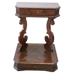
18th Century Italian Inlaid Walnut Antique Kneeler
Located in Casale Monferrato, IT
Rare antique Italian kneeler, 1780s.V ery refined made of walnut wood with small geometric inlaid decorations. Equipped with two practical drawers. Place this elegant antique Arma Christi...
Category

Italian Antique 18th Century More Furniture and Collectibles

Materials

Wood

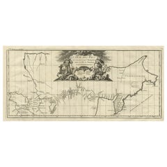
Antique Map with Details of Berings' Expedition into Russians' Far East, 1737
Located in Langweer, NL
Antique map titled 'Carte Des Pays traverses par le Capne. Beerings depuis la Ville de Tobolsk jusqua'a Kamtschatka'. This is the first printed map to illustrate Vitus Bering's fir...
Category

Antique 18th Century More Furniture and Collectibles

Materials

Paper

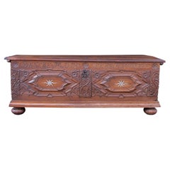
Early 18th Century Large Marriage Oak Trunk With a Vaulted Lid and Carvings
Located in London, GB
This 1727 oak trunk is of magnificent craftsmanship, showcasing intricate carvings and exquisite attention to detail. Crafted from solid oak, the trunk is sturdy and substantial, ref...
Category

German Baroque Antique 18th Century More Furniture and Collectibles

Materials

Oak

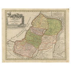
1718 Holy Land Map - Twelve Tribes, Six Provinces, Hand-Colored, Antique Map
Located in Langweer, NL
Title: Terra Sancta in XII olim Tribus nunc VI Provincias Dispertita Cartographer: Christoph Weigel the Elder (1654–1725) Publisher: Johann Ernst Adelbulner Publication Locatio...
Category

Antique 18th Century More Furniture and Collectibles

Materials

Paper

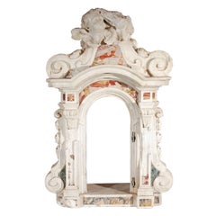
Baroque Period, Italian, Marble Tabernacle
Located in Los Angeles, CA
Fabulous, hand-carved and veneered, 1700's, solid marble tabernacle from an Italian church altar. The scrolling, side pillars are surmounted by a ...
Category

Italian Baroque Antique 18th Century More Furniture and Collectibles

Materials

Marble

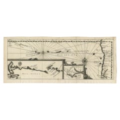
Antique Map of the Pacific Ocean by Renneville, 1702
Located in Langweer, NL
Antique map, untitled. A map of the Pacific Ocean, with the coast of Peru in the right edge and the outline of New Guinea in the left edge. In betwe...
Category

Antique 18th Century More Furniture and Collectibles

Materials

Paper

French 18th Century Balance Scale
Located in Round Top, TX
A handsome French 18th century balance scale in iron and brass. The balance mechanism is in iron. The foot and the plates are in brass. The...
Category

French Antique 18th Century More Furniture and Collectibles

Materials

Brass, Iron

Sculpted And Gilded Statue Of Saint Augustine, 18th Century
Located in Bilzen, BE
"Sculpted And Gilded Statue Of Saint Augustine, 18th Century" Southern Germany or Austria, circa 1700–1750 Carved oak, original water gilding and polychromy traces Height: 36.5 cm A...
Category

German Folk Art Antique 18th Century More Furniture and Collectibles

Materials

Wood

Print of Mourning of Greek Widows in Rama and Baptism in The River Jordan, 1730
Located in Langweer, NL
Description: Antique print titled 'Deuil des Femmes Greques a Rama' and 'Bapteme des Grecs dans le Jourdain'. The upper image depicts Mourning Greek widows in Rama, the lower ima...
Category

Antique 18th Century More Furniture and Collectibles

Materials

Paper

Hand-Colored Map of Delfland by Hendrik de Leth, 1740 – Delft & The Hague
Located in Langweer, NL
Hand-Colored Map of Delfland by Hendrik de Leth, 1740 – Delft & The Hague This beautifully preserved antique map titled "Nieuwe Gemeete Kaert van Delfland" was engraved by Hendrik d...
Category

Antique 18th Century More Furniture and Collectibles

Materials

Paper

Antique Map of Overijssel by Bachiene, 1758
Located in Langweer, NL
Antique map titled 'Over-Yssel'. Map of the Overijssel, the Netherlands. This map originates from 'Kort begrip der Oude en Nieuwe Staatkundige Geographie', by W.A. Bachiene, publishe...
Category

Antique 18th Century More Furniture and Collectibles

Materials

Paper

Antique Map of the County of Devon by Overton, 1713
Located in Langweer, NL
Antique map titled 'Devoniae Descriptio - The Description of Devon Shire'. Map of the County of Devon, England. This map originates from the 1713 edition of the 'Overton Atlas'. Henry Overton only revised the Devon map...
Category

Antique 18th Century More Furniture and Collectibles

Materials

Paper

18th Century French Tapestry
Located in Los Angeles, US
This is an authentic-style Aubusson tapestry pillow, showcasing the refined elegance of 18th-century French craftsmanship. Expertly woven in a flat-weave technique, the pillow featur...
Category

French Aubusson Antique 18th Century More Furniture and Collectibles

Materials

Wool, Feathers

Antique Print of a Stove Chimney, 1766
Located in Langweer, NL
Antique print titled 'A new invented Stove Chimney'. Print of various elements of a new invented stove chimney. This print originates from 'The Gentleman's Magazine'. Artists and Eng...
Category

Antique 18th Century More Furniture and Collectibles

Materials

Paper

Map of the Duchy of Pomerania – Antique Engraving by P. Schenk Jr., c. 1750
Located in Langweer, NL
Map of the Duchy of Pomerania – Antique Engraving by P. Schenk Jr., c. 1750 Antique map titled 'Ducatus Pomeraniae Tabula Generalis'. This historical map presents the Duchy of Pomer...
Category

Dutch Antique 18th Century More Furniture and Collectibles

Materials

Paper

Antique Map of Edom, an Ancient Kingdom in Transjordan, 1773
Located in Langweer, NL
Antique print titled 'Idumea, of thet Land der Philistynen'. Old map of Edom, an ancient kingdom in Transjordan located between Moab to the northeast, the Arabah to the west and the ...
Category

Antique 18th Century More Furniture and Collectibles

Materials

Paper

Decorative Map of the French Regions of Picardy, Artois & French Flanders, c1780
Located in Langweer, NL
Antique map titled 'Carte des Gouvernements de Flandre Francoise, d'Artois, de Picardie et du Boulenois.' An attractive example of Rigobert Bonne's 1771 decorative map of the Fre...
Category

Antique 18th Century More Furniture and Collectibles

Materials

Paper

Old Map of the Sinai Peninsula Showing the Mediterranean and the Red Sea, 1773
Located in Langweer, NL
Antique map of the Sinai Peninsula showing the Mediterranean Sea to the north and the Red Sea to the south. The map is decorated with images of a Persian wheel and a view of a vi...
Category

Antique 18th Century More Furniture and Collectibles

Materials

Paper

Antique Map of Portugal by Moll, 1727
Located in Langweer, NL
Antique map Portugal titled 'Portugal Agreeable to Modern History'. Detailed map of Portugal showing major routes, waterways, arch bishoprics, bis...
Category

Antique 18th Century More Furniture and Collectibles

Materials

Paper

Antique Bible World Map by R. & J. Wetstein, 1743
Located in Langweer, NL
Antique world map titled 'De Werelt Caart'. A scarce and richly detailed double hemisphere world map that was probably based on an earlier work by Cornelis Dankerts. This map has t...
Category

Antique 18th Century More Furniture and Collectibles

Materials

Paper

Large Map of Russian Discoveries in Siberia, Alaska & the Bering Strait, 1784
Located in Langweer, NL
1784 Russian Discoveries in Siberia, Alaska & the Bering Strait - Gerhard Friedrich Muller "Nouvelle Carte des Decouvertes Faites par des Vaisseaux Russiens Aux Cotes Inconnues de L'Amerique Septentrionale avec Les Pais Adiacents" is a seminal map by Gerhard Friedrich Muller, showcasing Russian discoveries in Siberia, Alaska, and the Bering Strait region. Originally published in 1754, this map served as a direct counter to Guillaume de L'Isle's speculative "fantasy" map of the same area, which prominently featured the fictitious Mer de l'Ouest (Sea of the West). This edition, published in 1784 by the Imperial Academy of Sciences in St. Petersburg, reflects the substantial geographic knowledge gained through Russian explorations, particularly the voyages of Vitus Bering. It accurately depicts the northern Pacific coasts, focusing on Siberia, the Aleutian Islands, and the Alaskan coast. The hand-coloring remains vibrant, emphasizing key geographic details, and a richly decorated rococo cartouche adorns the upper right, indicating the map's origins. This map is a significant artifact, illustrating the progression of cartographic accuracy and the influence of Russian expeditions in shaping the early knowledge of the North Pacific and Arctic regions. The 1784 edition of Gerhard Friedrich Muller's map features the routes of key Russian voyages that explored the North Pacific, specifically those related to the exploration of Siberia, Alaska, and the Bering Strait. These include: 1. Vitus Bering's Voyages (1728 and 1741) - The map shows routes of Vitus Bering, a Danish explorer in the Russian Navy, who led two important expeditions: - During his first Kamchatka Expedition (1728), Bering navigated through what is now known as the Bering Strait, proving that Siberia and Alaska were separated by a sea. - His second Kamchatka Expedition (1741) extended further eastward to Alaska. This journey greatly expanded European knowledge of the northern Pacific and confirmed Alaska as part of the North American continent. 2. Aleksei Chirikov's Route (1741) - As part of the second Kamchatka Expedition, Aleksei Chirikov, who was Bering's second-in-command, led a separate ship and reached the Alaskan coast, discovering the southeastern parts of Alaska and providing further detailed knowledge of the area. 3. Russian Navigators in the Aleutian Islands - The map also shows the exploration routes in and around the Aleutian Islands, which were instrumental for Russian fur...
Category

Antique 18th Century More Furniture and Collectibles

Materials

Paper

Antique Map of the Persian Gulf and Caspian Sea Region by R. Bonne, 1780
Located in Langweer, NL
Antique print titled 'Carte de la Perse, de la Georgie, et de la Tartarie Independante'. Shows the region from the Persian Gulf and Caspian Sea in the wes...
Category

French Antique 18th Century More Furniture and Collectibles

Materials

Paper

Antique Print of Bramham Park by Campbell, 1725
Located in Langweer, NL
Antique print titled 'The Elevation of Braman Park (..)'. Old engraving of Bramham Park in Bramham. This print originates from 'Vitruvius Britannicus' by Colen Campbell. Artists and ...
Category

Antique 18th Century More Furniture and Collectibles

Materials

Paper

Antique Map of Java and Madura Island, Indonesia, c.1760
Located in Langweer, NL
Antique map titled 'Idee de l'Isle de Java.' Well engraved and attractive chart of the island shows all principal harbors and coastal details, plus rivers, mountains and volcanoe...
Category

Antique 18th Century More Furniture and Collectibles

Materials

Paper

18th Century French Tapestry Pillow
Located in Los Angeles, US
This exquisite 18th-century French tapestry pillow measures 15” x 8” and showcases a beautifully aged patina with warm, earthy tones of burnt orange, golden tan, and deep brown. Wove...
Category

Unknown Aubusson Antique 18th Century More Furniture and Collectibles

Materials

Wool, Feathers

Antique Map of a Bay on the Coast of Chile, South America, c.1749
Located in Langweer, NL
Antique map titled 'Plan van een Baai en Haven aan de Kust van Chili (..) - Plan d'une Baye de la Côte du Chili (..)'. Original antique map of a bay on the coast of Chile discovered ...
Category

Antique 18th Century More Furniture and Collectibles

Materials

Paper

Original Drawing, Circle of Giovanni Battista Tiepolo 1696-1770 Venice, Italy
By Giovanni Battista Tiepolo
Located in Vero Beach, FL
Original Drawing, Circle of Giovanni Battista Tiepolo 1696-1770 Venice, Italy Although we offer this old master drawing as circle of Tiepolo, we are convinced, based on the composi...
Category

Italian Rococo Antique 18th Century More Furniture and Collectibles

Materials

Paper

Map of the Electorate of Bavaria, Incl Lake Constance, by Jesuit Scherer, c.1700
Located in Langweer, NL
Antique map titled 'Electorat Bavariae.' Map of the Electorate of Bavaria by the Jesuit Heinrich Scherer. The lower map shows the Lake Constance. Source unknown, to be determined. ...
Category

Antique 18th Century More Furniture and Collectibles

Materials

Paper

18th Century Walnut Prayer Kneeler from the Collection of italian Prince
Located in Nicolosi, IT
18th Century Walnut Prayer Kneeler from the Collection of Italian Prince Ambrogio II Caracciolo We present a unique piece of history! This magnificent kneeler in solid walnut dates ...
Category

Italian Louis XV Antique 18th Century More Furniture and Collectibles

Materials

Walnut

Old Original Hand-Colored Engraving of Various Apples, 1758
Located in Langweer, NL
Antique print depicting apple variaties including the Pigeon of Passe Pomme, Rode Herfst- of Winter Calville, Witte Ribbert of Ribling, Winter Parmain Pepping, Paasch Appel, Wyker Pe...
Category

Antique 18th Century More Furniture and Collectibles

Materials

Paper

Rare 18th Century Waywiser By Jonathan Sissons
Located in Lincolnshire, GB
A super example of an early waywiser by Jonathan Sissons with a finely engraved center of the dial and a silvered readings dial, with the original hands. The oak and mahogany case ha...
Category

English Antique 18th Century More Furniture and Collectibles

Materials

Silver, Brass

Spanish 17th Century Malle - Marriage Trunk
Located in Round Top, TX
A very handsome 17th century marriage trunk from the Catalan region of Spain. Beautifully constructed from wood, clad with leather and wonderful iron or...
Category

Spanish Antique 18th Century More Furniture and Collectibles

Materials

Iron

1750 Bellin Map of the Red River (Tonkin River) and Hanoi, Vietnam
Located in Langweer, NL
Title: 1750 Bellin Map of the Red River and Hanoi, Vietnam Description: This finely engraved eighteenth-century French map, titled Carte du Cours de la Riviere de Tunquin, was created by the renowned cartographer Jacques-Nicolas Bellin and published in 1750. It depicts the course of the Red River, historically referred to as the Tonkin River, from Hanoi, labeled as Cacho, Ville Capitale du Tunquin, to the Gulf of Tonkin, labeled as Baye de Tunquin. Bellin’s work was based on navigational surveys by an English explorer, as stated in the title, reflecting the growing European interest in Southeast Asia during the early colonial period. The Red River Delta was a crucial region for trade and agriculture, forming the backbone of Vietnam’s economic and cultural history. The river originates in China and flows through northern Vietnam, passing through Hanoi before emptying into the Gulf of Tonkin. This map captures the strategic importance of the river, as it served as a major trade route for goods and a point of interest for European navigators, merchants, and missionaries seeking access to Indochina. The map includes numerous geographical details. Hanoi is prominently labeled as the capital of Tonkin, a historical term used by Europeans to describe northern Vietnam. The surrounding settlements, islands, and tributaries are carefully marked, illustrating the intricate network of waterways that characterized the region. Notable features include Île de la Potterie, referring to a location known for ceramic production, and various sandbanks and fortified locations along the river. A decorative compass rose is placed in the upper left corner, reinforcing the map’s navigational purpose. The scale of measurement is provided in French leagues, labeled as Grandes Lieues...
Category

Antique 18th Century More Furniture and Collectibles

Materials

Paper

18th Century, Gilded, Bishop's Crest
Located in Los Angeles, CA
Relief carved, gessoed and 22-karat gold gilded, Italian bishop's crest featuring three bees amidst foliate scrolls, drapery swags, and tassles.
Category

Italian Antique 18th Century More Furniture and Collectibles

Materials

Gesso, Wood

Detailed Map of Southeast Asia From the Tip of Cambodia to Java, 1739
Located in Langweer, NL
Antique map titled 'Nieuwe kaart van de Sundasche Eilanden als Borneo, Sumatra en Groot Iava & c'. Detailed map of Southeast Asia, extending from the tip of Cambodia to Java. Thi...
Category

Antique 18th Century More Furniture and Collectibles

Materials

Paper

Ancient Babylon with The Tower of Babel According to Herodotus & Kircherus, 1730
Located in Langweer, NL
Antique print titled 'Platte Grond van de Stad Babilon, volgens Herodotus en A. Kircherus'. This original antique print shows a view of ancient Babylon with the tower of Babel...
Category

Antique 18th Century More Furniture and Collectibles

Materials

Paper

Antique Map of France with Decorative Title Cartouche
Located in Langweer, NL
Antique map titled 'Carte de la France'. Original old map of France. This map originates from 'Le Petit Atlas Maritime Recueil De Cartes et Plans Des Quatre Parties Du Monde (..) by ...
Category

Antique 18th Century More Furniture and Collectibles

Materials

Paper

Antique Map of the Cities of the Province of Hu-Quang by Basire, 1738
Located in Langweer, NL
Antique print titled 'Cities of the Province of Hu-Quang'. Old map depicting four walled cities of the Chinese Qing dynasty province of Hu-Quang (modern day HUNAN and part of surroun...
Category

Antique 18th Century More Furniture and Collectibles

Materials

Paper

Rare Antique Print of Temptation and Expulsion, c.1780
Located in Langweer, NL
Antique print religion titled 'Tulit Igitur Mulier de Fructu Illius, et Comedit (..)'. This print depicts Temptation and Expulsion. Originates from 'Frescoes in the Sistine Chapel'. ...
Category

Antique 18th Century More Furniture and Collectibles

Materials

Paper

18th Century French Tapestry Pillow
Located in Los Angeles, US
A beautifully aged 18th-century French Aubusson tapestry pillow, handwoven in wool and feather-filled for softness and structure. This lumbar cushion features an abstracted botanical...
Category

French Aubusson Antique 18th Century More Furniture and Collectibles

Materials

Wool, Feathers

Aubusson Tapestry Cushion
Located in Palm Beach, FL
Antique Aubusson tapestry cushion with figures 18th century Measures: 20" x 18".
Category

French Antique 18th Century More Furniture and Collectibles

Materials

Wool

Antique Coastal Map of West Sumatra 'Indonesia' by J. Mannevillette, 1745
Located in Langweer, NL
Antique map titled 'Carte de la côte occidentale de l'isle Sumatra depuis la ligne équinoctiale jusqu'au détroit de la Sonde'. Beautiful coastal map of We...
Category

Antique 18th Century More Furniture and Collectibles

Materials

Paper

Original Detailed Antique Map of Southern India and Most of Ceylon, 1744
Located in Langweer, NL
Antique map titled 'A Map of India on the west Side of the Ganges, comprehending the coasts of Malabar, Coromandel and the Island Ceylon'. Map of Southern India and most of Ceylo...
Category

Antique 18th Century More Furniture and Collectibles

Materials

Paper

Antique Map of the British Isles by H. Chatelain, 1719
Located in Langweer, NL
Beautiful hand colored large format map of the British Isles, with large insets of the Eastern and Western Hemispheres and the coats of arms for Engl...
Category

Antique 18th Century More Furniture and Collectibles

Materials

Paper

Antique Map of Germany, the Netherlands, Bohemia, Bavaria and Switzerland, 1785
Located in Langweer, NL
Antique map titled 'Germany and the Netherlands from the latest authorities'. Depicts Germany, the Netherlands and the surrounding region including Bohemia, Bavaria, and Switzerland....
Category

Antique 18th Century More Furniture and Collectibles

Materials

Paper

1718 Ides & Witsen Map "Route D'amsterdam a Moscow Et De La Ispahan Et Gamron
Located in Norton, MA
1718 Ides & Witsen map, entitled "Route D'Amsterdam A Moscow Et De La Ispahan Et Gamron," Ric.b005 Subject: Eastern Europe and Central Asia Period: 1718 (published) Publicati...
Category

Dutch Antique 18th Century More Furniture and Collectibles

Materials

Paper

SECOND HALF OF THE 18th CENTURY PAIR OF NEOCLASSIC BEDSIDE TABLES
Located in Firenze, FI
Pair of bedside tables in solid fir wood and walnut veneer. The bedside tables are decorated with geometric inlays in fruit wood and walnut, present on the top and sides, which give ...
Category

Italian Neoclassical Revival Antique 18th Century More Furniture and Collectibles

Materials

Fruitwood, Walnut, Fir

Antique Map of the World on Mercator Projection by Anson, 1749
Located in Langweer, NL
Antique map titled 'Nieuwe Wereld Kaart waar in de Reizen van den Hr. Anson rondsom de Wereld'. Original antique map of the world on Mercator'...
Category

Antique 18th Century More Furniture and Collectibles

Materials

Paper

Striking Antique Map Centered on the Malay Peninsula
Located in Langweer, NL
Antique map titled 'D'Indiaanze Landschappen Zeen en Eylanden, van Couchin af tot in de Moluccos (...)'. Striking map of the region from the Philippines and Formosa to India and the ...
Category

Antique 18th Century More Furniture and Collectibles

Materials

Paper

Dutch Antique Map of the West Coast of Africa, to the Cape of Good Hope, 1747
Located in Langweer, NL
Antique map of the Coast of Africa titled 'Kaart van de West Kust van Afrika (..)'. Map of the west coast of Africa, from 11 degrees south latitude to the Cape of Good Hope. This...
Category

Antique 18th Century More Furniture and Collectibles

Materials

Paper

Detailed Map of Friesland, Groningen and Drenthe, The Netherlands, 1706
Located in Langweer, NL
Antique map tited 'Frisiae Dominium vernacule Friesland verdeeld met de hoofd-deelen van Oostergoo, Westergoo en Sevenwolden (..)'. Detailed map of Friesland, Groningen and Drenthe, ...
Category

Antique 18th Century More Furniture and Collectibles

Materials

Paper

18th / Early 19th Century Miniature Painting
Located in Delft, NL
An 18th / early 19th century miniature painting An 18th / early 19th century miniature painting painted on glass and framed. The copper framed miniature painting in another copp...
Category

European Antique 18th Century More Furniture and Collectibles

Materials

Copper

Antique Map of the Middle East by Mortier, 1700
Located in Langweer, NL
Antique map titled 'Carte de la Situation du Paradis Terrestre (..)'. Detailed map of the Holy Land and the Middle East, centered on the Garden of Eden and including a large Cyprus. ...
Category

Antique 18th Century More Furniture and Collectibles

Materials

Paper

Antique Map of India and Ceylon, along with the Maldives
Located in Langweer, NL
Antique map titled 'Stato del Mogol con l'Isole di Ceilan e Maldive'. Beautiful map of India and Ceylon, along with the Maldives. Includes a large decorative title cartouche. The map...
Category

Antique 18th Century More Furniture and Collectibles

Materials

Paper

Louis XVI Style Pair of French Bronze Curtain Holdbacks, Gilded and Chiseled
Located in Prato, Tuscany
We kindly invite you to read the full description, as we aim to provide detailed technical and historical information to ensure the authenticity of our items. This is a unique and st...
Category

French Louis XVI Antique 18th Century More Furniture and Collectibles

Materials

Bronze

Antique Irish George II Needlework Panel Pole Screen Fire Screen C.1730
Located in London, GB
Antique Irish George II Needlework Panel Pole Screen C.1730 Depicting a still life of flowers, on a turned stem, the tripod base carved with scal...
Category

Irish Chippendale Antique 18th Century More Furniture and Collectibles

Materials

Mahogany

Map of Saint Helena Island: Early 18th-Century Copper Engraving by F. Bernard
Located in Langweer, NL
Map of Saint Helena Island: Early 18th-Century Copper Engraving by F. Bernard This rare and beautifully detailed copper engraving of Saint Helena Island dates from around 1722 and...
Category

Antique 18th Century More Furniture and Collectibles

Materials

Paper

Antique Map of Africa with a Decorative Dedication to the Dauphin, 1717
Located in Langweer, NL
Antique map titled 'L'Afrique, Dressée Selon les Dernieres Relat. et Suivant les Nouvelles Decouvertes (..).' This map is a reduced derivative of De Fer's wall map of Africa (1696-98) with its characteristic thickened west coast. Unusual islands appear in the Atlantic and Indian Oceans including a mythical second island of St. Helena. Monomotapa is shown in the south and the southwest coastline is distorted and there is an incorrect placement and shape of the Cape of Good Hope. In Central Africa is a paragraph concerning the origin of the Nile in Abyssinia, however, the two sub-equatorial Ptolemaic lakes are still shown on the map. The map is graced with a decorative dedication to the Dauphin and a title cartouche featuring lime kilns. The map was first published in 1700. This scarse map originates from: 'Introduction a la geographie - avec unde description historique sur toutes...
Category

Antique 18th Century More Furniture and Collectibles

Materials

Paper

Old Print of Stone with Elephants from the Bridge of Constantine, Algeria, 1773
Located in Langweer, NL
Antique print titled 'Steen in de brug van het oude Cirta (..)'. Old print depicting a stone with elephants from the bridge of Cirta/Constantine. Also depicts other architectural...
Category

Antique 18th Century More Furniture and Collectibles

Materials

Paper

Antique Engraving of Deucalion and Pyrrha of Phthia, Thessaly, Greece, 1733
Located in Langweer, NL
Antique print titled 'Deucalion & Pyrrha (..)'. This print depicts Deucalion and Pyrrha. Deucalion, who reigned over the region of Phthia, had been forewarned of the flood by his...
Category

Antique 18th Century More Furniture and Collectibles

Materials

Paper

Read More

Medal-Worthy Memorabilia from Epic Past Olympic Games

Get into the games! These items celebrate the events, athletes, host countries and sporting spirit.

Ahoy! You’ve Never Seen a Collection of Sailor Art and Kitsch Quite Like This

French trendsetter and serial collector Daniel Rozensztroch tells us about his obsession with objects related to seafaring men.

39 Incredible Swimming Pools

It's hard to resist the allure of a beautiful pool. So, go ahead and daydream about whiling away your summer in paradise.

Pamela Shamshiri Shares the Secrets behind Her First-Ever Book and Its Effortlessly Cool Interiors

The sought-after designer worked with the team at Hoffman Creative to produce a monograph that beautifully showcases some of Studio Shamshiri's most inspiring projects.

Moroccan Artworks and Objects Take Center Stage in an Extraordinary Villa in Tangier

Italian writer and collector Umberto Pasti opens the doors to his remarkable cave of wonders in North Africa.

Montecito Has Drawn Royalty and Celebrities, and These Homes Are Proof of Its Allure

Hollywood A-listers, ex-pat aristocrats and art collectors and style setters of all stripes appreciate the allure of the coastal California hamlet — much on our minds after recent winter floods.

Whaam! Blam! Pow! — a New Book on Pop Art Packs a Punch

Publishing house Assouline and writer Julie Belcove have teamed up to trace the history of the genre, from Roy Lichtenstein, Andy Warhol and Yayoi Kusama to Mickalene Thomas and Jeff Koons.

What Makes a Gem-Encrusted Chess Set Worth $4 Million?

The world’s most opulent chess set, weighing in at 513 carats, is literally fit for a king and queen.
Recently Viewed

View All