Items Similar to Antique Map with Details of Berings' Expedition into Russians' Far East, 1737

Want more images or videos?
Request additional images or videos from the seller
1 of 6
Antique Map with Details of Berings' Expedition into Russians' Far East, 1737
About the Item
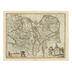
Antique map titled 'Carte Des Pays traverses par le Capne. Beerings depuis la Ville de Tobolsk jusqua'a Kamtschatka'.
This is the first printed map to illustrate Vitus Bering's first voyage, representing the first broadly accurate cartography of the Russian Far East.
In December 1724, Czar Peter the Great ordered the Danish-born Captain-Commander Vitus Bering (1681-1741) to lead the First Kamchatka Expedition (1725-30), in a effort to consoldate Russia's claims to regions in the Far East. Bering's party set out from St. Petersburg in January 1725, and after a grueling two-year journey, arrived in Okhotsk in Janaury 1727, on the Pacific Coast. The expedition then continued by ship to explore the massive Kamchatka Peninsula that runs down the East Coast of Siberia, and the shorelines beyond up to what is now the western side of the Bering Strait, dividing Asia from North America. As shown on the map, a series of forts, outposts and missions had already been established in the Russian Far East.
While Bering's expedition was by no means the first expedition to traverse Russia, it was the first to explore the coast beyond Kamchatka and to properly map the various river systems of the eastern interior of Siberia and to chart much of the Pacific Coast. The present map extends from Tobolsk in the west, the traditional capital of Siberia, all the way eastwards to embrace the Kamchatka Peninsula and the coastlines up to the easternmost point of the Chukchi Peninsula. In between are depicted large stretches of the Ob, Irtysh, and Lena Rivers, their tributaries and Lake Baikal, the World's deepest lake. The coastline, shown from Okhotsk, Russia's gateway the the Pacific (founded 1650), up to the Bering Strait is quite impressively mapped given the difficult circumstances in which Bering operated. The First Kamchatka Expedition was deemed a great success, and the Russian court was highly impressed by the vast distances travelled and the quality of Bering's maps and written reports.
Czarina Anna ordered Bering to lead a much larger multi-pronged expedition to the Far East. Although technically known as the Second Kamchatka Expedition (1732-41), this endeavor would have historic and far-reaching implications, as it would be the first expedition to discover and partially map what is now Alaska. It opened the way to the lengthy Russian presence on the Pacific Coast of North America (which would last until 1867), and the great period of exploration of the Pacific Northwest that would include the great names of Cook, Vancouver, Mackenizie and Lewis & Clark.
The first edition of this map appeared in Jean-Baptiste Du Halde's Description de la China (Paris, 1735), while the present edition was issued in Paris by the eminent cartographer J.B.B. D'Anville in 1737, which features cartouches added to the map. A critical map relating the exploration of the Russian Far East and the North Pacific.
Artists and Engravers: Jean Baptiste Bourguignon d'Anville (1697-1782) was a geographer and cartographer from France. His fame was established through his historical maps, which shows careful accurate work and are based largely on original research.
- Dimensions:Height: 12.96 in (32.9 cm)Width: 22.64 in (57.5 cm)Depth: 0 in (0.02 mm)
- Materials and Techniques:
- Period:1730-1739
- Date of Manufacture:1737
- Condition:Condition: Good, given age. A few small unobtrusive spots. Original folds as issued. General age-related toning and/or occasional minor defects from handling. Please study image carefully.
- Seller Location:Langweer, NL
- Reference Number:
About the Seller
5.0
Platinum Seller
These expertly vetted sellers are 1stDibs' most experienced sellers and are rated highest by our customers.
Established in 2009
1stDibs seller since 2017
1,919 sales on 1stDibs
Typical response time: <1 hour
- ShippingRetrieving quote...Ships From: Langweer, Netherlands
- Return PolicyA return for this item may be initiated within 14 days of delivery.
More From This SellerView All
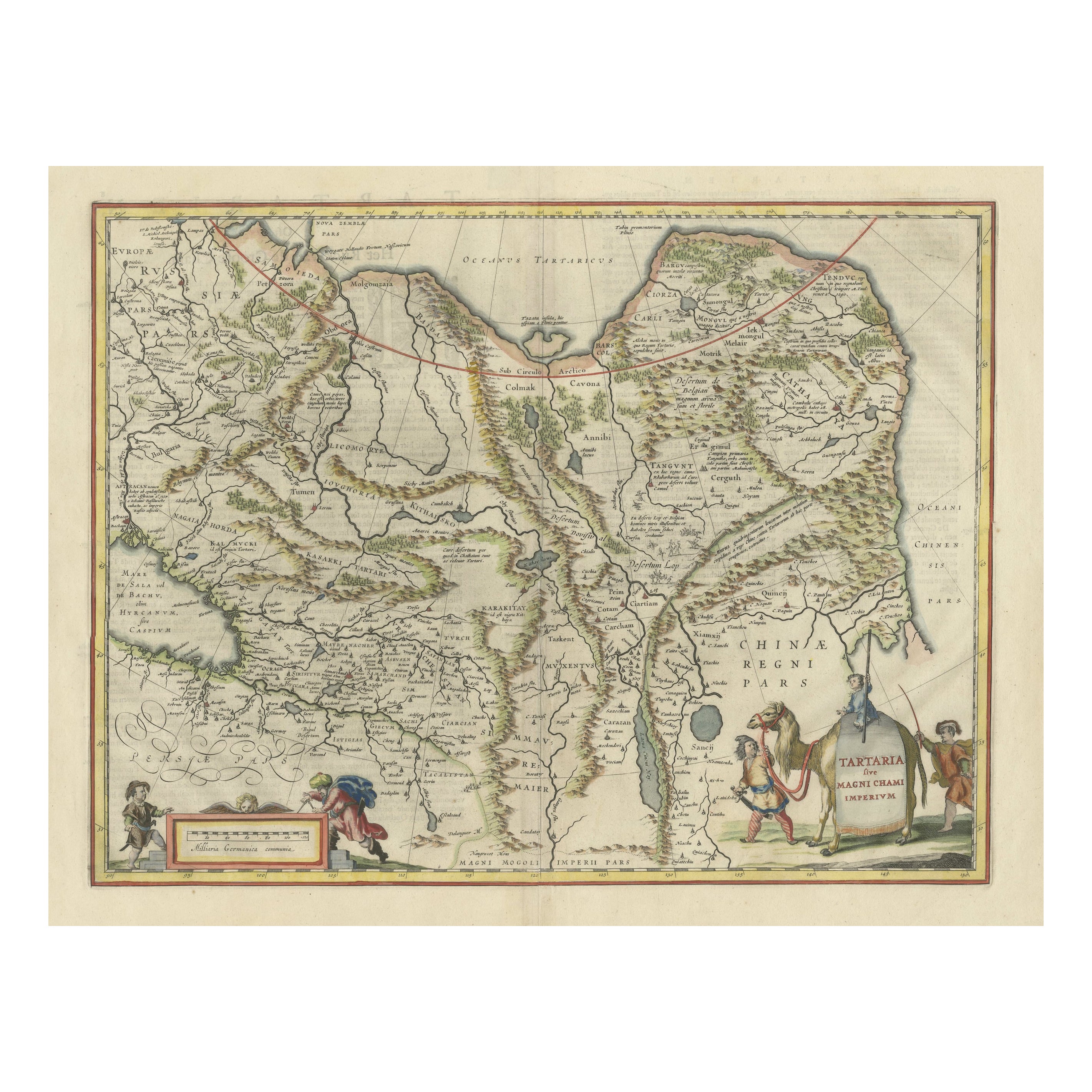
- Old Genuine Antique Map of Tartary in the Russian Far EastLocated in Langweer, NLOriginal antique map titled 'Tartaria sive Magni Chami Imperium'. This great map of Tartary covers all of eastern Asia between the Caspian Sea and northern China and Manchuria. Being...Category
Antique Mid-17th Century Maps
MaterialsPaper
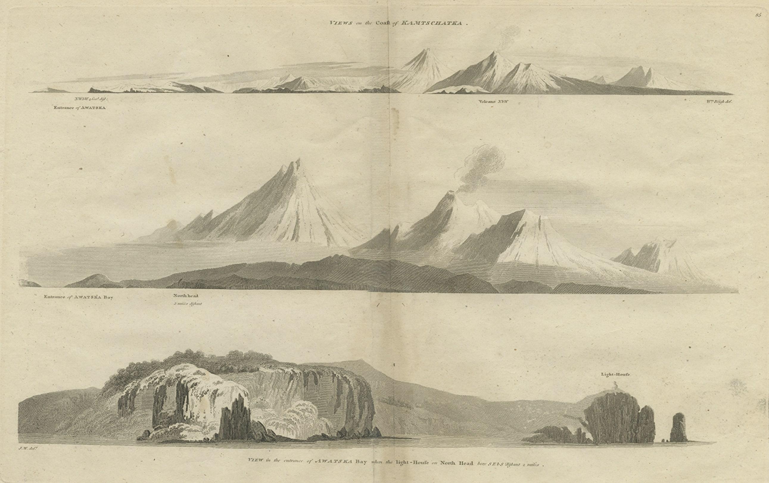
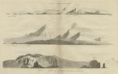
- Antique Print with Coastal Views of Kamchatka in The Russian Far East, c.1784Located in Langweer, NLAntique print titled 'Views of the Coast of Kamtschatka (..)'. Print with coastal views of Kamchatka including volcanoes. Originates from an edition of Cook's Voyages. Artists and ...Category
Antique 18th Century Prints
MaterialsPaper
- Original Antique Map of Tartary 'Northern China & Far Eastern Russia', 1757Located in Langweer, NLAntique map titled 'Carte de la Tartarie Orientale (..)'. Original antique map of what is present day northern China and far eastern Russia. Centere...Category
Antique 1750s Maps
MaterialsPaper
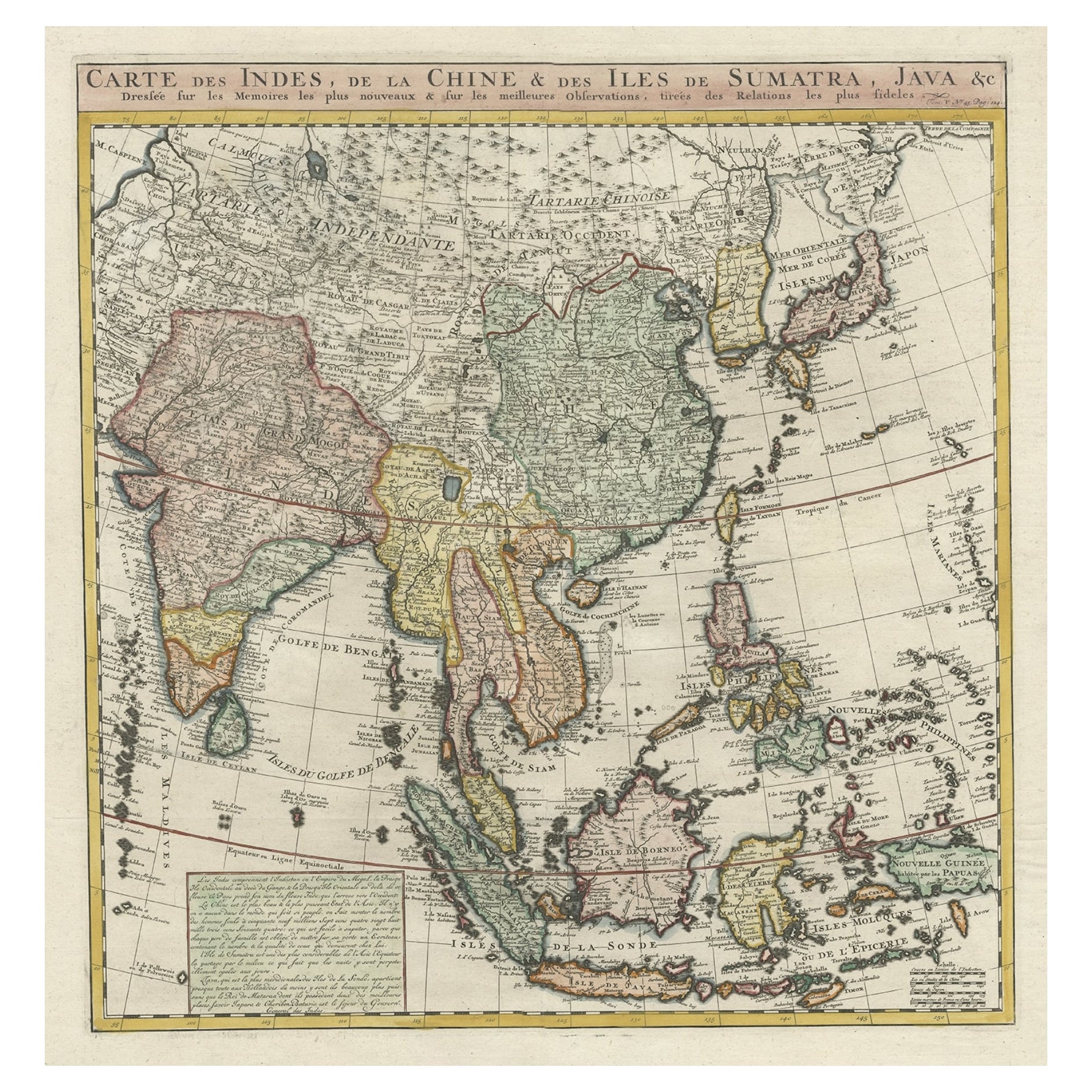
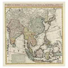
- Detailed Original Antique Map of India, Southeast Asia and the Far East, 1719Located in Langweer, NLAntique map titled 'Carte des Indes, de la Chine & des Iles de Sumatra, Java & c'. Detailed map of India, Southeast Asia and the Far East, extending from Gujerat to the supposed "T...Category
Antique 1710s Maps
MaterialsPaper
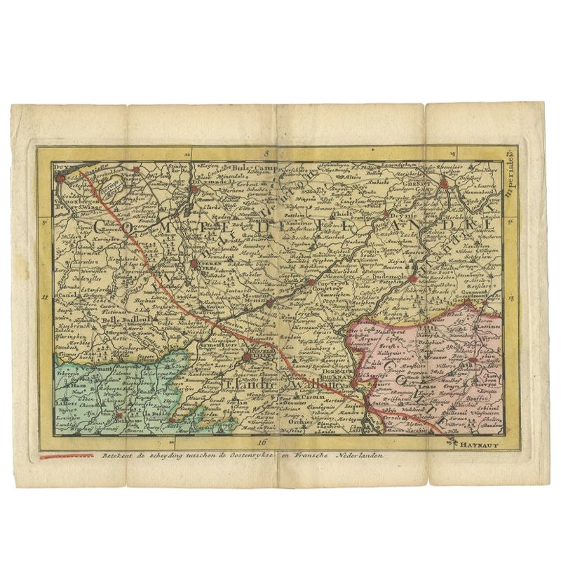
- Antique Map of the Region of Flanders in Belgium, 1737Located in Langweer, NLUntitled map of the region of Flanders, Belgium. This map originates from 'Nieuw en beknopt Kaart-Boekje vertoonende de XVII. Nederlandse Provintien (..)'. Artists and Engravers: A...Category
Antique 18th Century Maps
MaterialsPaper
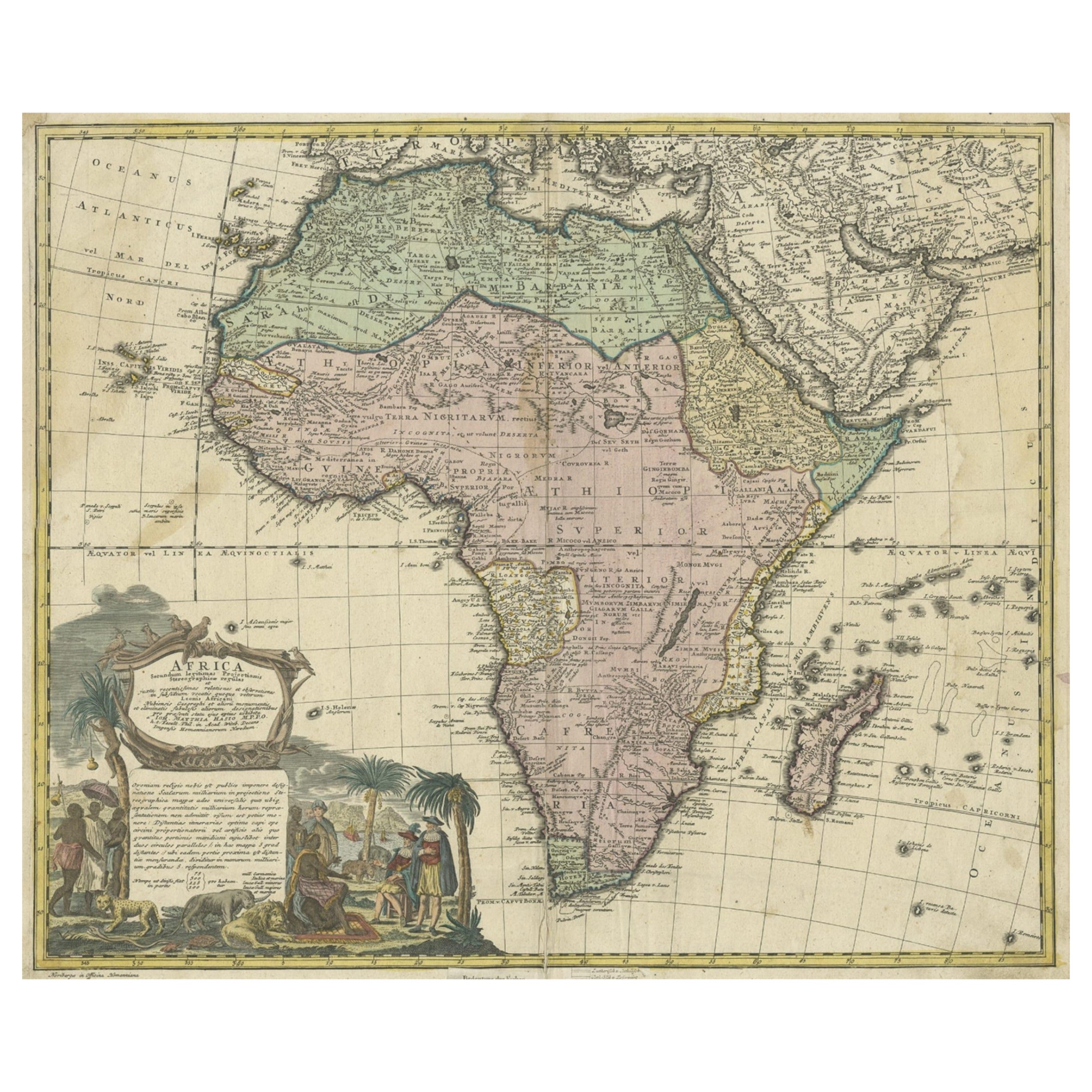
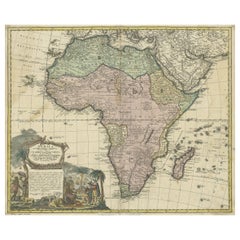
- Antique Map of Africa, Cartouche with Elephant Tusks and Horned Serpent, 1737Located in Langweer, NLAntique map of Africa titled 'Africa Secundum Legitimas Projectionis Stereographicae regulas (..)'. Johann Matthias Haas' revision of J.B. Homann's 1715 map of Africa, augmented to include important cartographic developments as recorded by Guillaume Delisle and D'Anville. The map presents a fairly accurate picture without most of the fictitious lakes and rivers of previous cartography, focusing on the known coastal regions of the continent, leaving the interior blank or marked Terra Incognito. Egypt, Nubia and Abyssinia are shown as distinct entities, Lake Nyasa is shown as Lac Marawi, and the Congo is located. The Dutch settlements of Castell Batov and Stellenbosch are shown at the Cape. The most striking feature of the map is the large title cartouche that is framed by elephant tusks and a horned serpent. In the foreground is a scene of natives negotiating with European traders, surrounded by indigenous animals. In the background is a view of Table Bay...Category
Antique 18th Century Maps
MaterialsPaper

You May Also Like
- Original Antique Map of Russia By Arrowsmith. 1820Located in St Annes, LancashireGreat map of Russia Drawn under the direction of Arrowsmith Copper-plate engraving Published by Longman, Hurst, Rees, Orme and Brown, 1820 Unframed.Category
Antique 1820s English Maps
MaterialsPaper
- Original Antique Map of South East Asia, Arrowsmith, 1820Located in St Annes, LancashireGreat map of South East Asia Drawn under the direction of Arrowsmith Copper-plate engraving Published by Longman, Hurst, Rees, Orme and Brown, 1820 Unframed.Category
Antique 1820s English Maps
MaterialsPaper
- Original Antique Map of South East Asia by Becker, circa 1840Located in St Annes, LancashireGreat map of South East Asia Steel engraving with original color outline Engraved by Becker Published by Virtue, circa 1840. Unframed.Category
Antique 1840s English Other Maps
MaterialsPaper
- Original Antique Map of South East Asia by Thomas Clerk, 1817Located in St Annes, LancashireGreat map of South East Asia Copper-plate engraving Drawn and engraved by Thomas Clerk, Edinburgh. Published by Mackenzie And Dent, 1817 Unframed.Category
Antique 1810s English Maps
MaterialsPaper
- Original Antique English County Map, East Yorkshire, J & C Walker, 1851Located in St Annes, LancashireGreat map of The East Riding of Yorkshire Original colour By J & C Walker Published by Longman, Rees, Orme, Brown & Co. 1851 Unframed.Category
Antique 1850s English Other Maps
MaterialsPaper
- Antique Map of Principality of MonacoBy Antonio Vallardi EditoreLocated in Alessandria, PiemonteST/619 - "Old Geographical Atlas of Italy - Topographic map of ex-Principality of Monaco" - ediz Vallardi - Milano - A somewhat special edition ---Category
Antique Late 19th Century Italian Other Prints
MaterialsPaper


