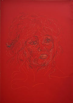
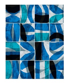
Brigitte #2 #2
By Ant Pearce
Located in Brecon, Powys
Brigitte Series Emulsion and cotton sewn on cotton on paper
Category
2010s Assemblage Emulsion More Art
Materials
Cotton, Cotton Canvas, Emulsion, Ink, Paper
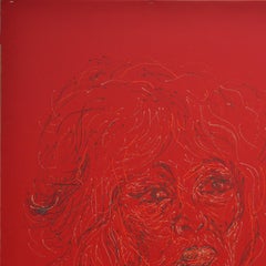
Brigitte #2 #2
By Ant Pearce
Located in Brecon, Powys
Brigitte Series Emulsion and cotton sewn on cotton on paper
Cotton, Cotton Canvas, Emulsion, Ink, Paper

$16,022
H 49.61 in W 46.86 in D 2.76 in
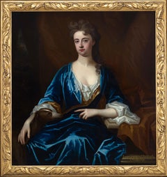
Portrait of Lady, Barbara Herbert, Countess of Pembroke c.1708, Large Painting
Located in London, GB
Portrait of Barbara Herbert, Countess of Pembroke c.1708 Charles d’Agar (1669-1723) This magnificent large-scale portrait, presented by Titan Fine Art, depicts the British court of...
Cotton Canvas, Oil
$10,522
H 47.67 in W 38.13 in
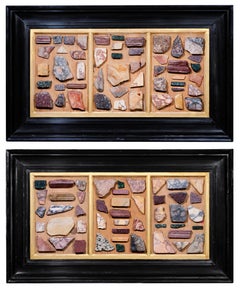
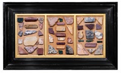
"The collection of a lifetime" : two triptychs featuring antique marble samples
Located in PARIS, FR
These two highly decorative triptychs feature 94 samples of antique marble, presumably collected by the same collector in the early 20th century from archaeological sites in Rome and...
Alabaster, Granite, Marble
$1,350Sale Price|79% Off
H 48 in W 60 in D 1.75 in
Mixed Media 3D Artwork 'Mariupol Rising from the Ashes' in Pop Art
Located in LOS ANGELES, CA
**NEW YEAR FINAL 90 DAYS SUPER SALE UNTIL MARCH 31ST** **STORE CLOSURE - UP TO 80% OFF - TAKE ADVANTAGE OF IT** **EVERYTHING MUST GO UNTIL APRIL1ST!** ...
Resin, Rubber, Cotton Canvas, Acrylic
$75,000
H 50 in W 40 in
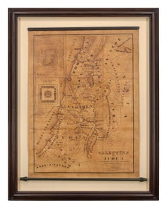
Map of Palestine or Judea, Illustrating the History of the New Testament
By Rev. Nathan B. Rogers
Located in New York, NY
Pen and ink on paper, laid down on canvas, mounted to wooden scroll bars Signed and dated lower right: “Drawn by N. B. Rogers August. 1843” Inscribed with an ownership inscription on the verso: Rev. E. D. Daniels, Palmer, Mass. Provenance: Rev. Eugene Davidson Daniels, Palmer, Massachusetts, 1871 This extraordinary manuscript map is a rare survivor of the devotional and educational culture of New England in the first half of the nineteenth century. Although at first glance resembling a large-scale engraving or printed publication, this precisely rendered wall map was entirely drawn by hand, the product of meticulous research by a minister working in isolation in rural Maine. The map shows New Testament era cities, towns, tribal areas, and political borders as well as physical features such as rivers, lakes, mountains, and hills (indicated by half-tone cross-hatching). On to this geographically accurate rendering of the Holy Land, Rogers has located and inscribed significant locales mentioned in the Gospels and has annotated these places with relevant citations from the Bible. He further records these by plotting the travels of Jesus on what resemble a series of trails across the Holy Land. Each is distinguished by a different pattern of dots and dashes – correlated to an explanatory table at the lower right. From this we know that these lines document the “Flight into Egypt and return,” “Travels of Christ from Nazareth to Jerusalem and return,” “Travels from the commencement of his Ministry to the first Passover,” “Travels from the first and the second Passover,” “Travels from Jerusalem to Galilee after the 2nd Passover,” and “Travels from the third Passover to the Crucifixion.” An inset map of “Jerusalem...
Canvas, Paper, Ink, Pen
$3,900
H 9 in W 20 in D 6 in
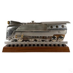
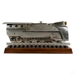
Train Engine Folk Outsider Art Deco Assemblage Found Objects Contemporary Statue
Located in New York, NY
Train Engine Folk Outsider Art Deco Assemblage Found Objects Contemporary Statue Actual Dimensions: 8.75 X 19.75 X 5.75 inches Michael Riley (Mike Riley) (American, born 1957). A model train engine statue in mixed media. Metal, wood, and other elements. An Art Deco Moderne style design produced from found objects, including garden hose fitting, sliding door track, trombone instrument counter weights, flute instrument...
Steel, Stainless Steel
Mystic Rituals 3
By Brad Ellis
Located in Los Angeles, CA
This unframed, signed, limited edition pigment print by artist Brad Ellis exists in an edition of 30. Paper size is 46"h x 35"w with an image size of 40"h x 29"w. Brad Ellis is a Da...
Cotton, Archival Ink, Archival Paper, Digital, Archival Pigment, Digital...
$3,800
H 40 in W 30 in D 2 in
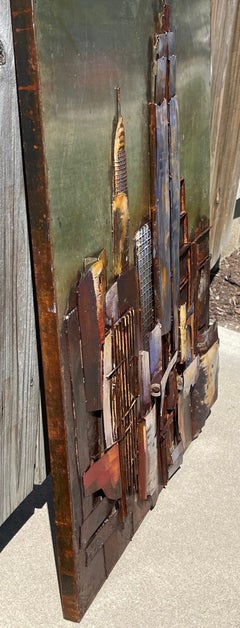
Folk Outsider Naive Art Metal NYC Cityscape Sculpture Wall Hanging Contemporary
Located in New York, NY
Folk Outsider Naive Art Metal NYC Cityscape Sculpture Wall Hanging Contemporary "NYC Cityscape" 39 1/2 x 29 1/2 x 2 inches Unsigned Offered is an extraordinary hand crafted wall s...
Metal
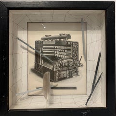
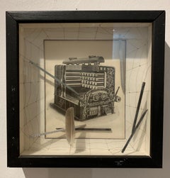
Bright Idea Boiler
Located in San Diego, CA
Bright Idea Boiler is an assemblage composed of paper, wood, wire and glass. The background shows a drawing of a spider web on which a paper cut out of the Bright Idea Boiler is supe...
Glass, Wood, Paper
Paradigm Blue
By Brad Ellis
Located in Los Angeles, CA
This unframed, signed, limited edition pigment print by artist Brad Ellis exists in an edition of 30. Paper size is 30"h x 24"w with an image size of 24"h x 19"w. Brad Ellis is a Da...
Cotton, Archival Ink, Archival Paper, Digital, Archival Pigment, Digital...

$20,000
H 10 in W 18.25 in D 8.25 in
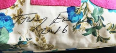
Always Me, limited edition handbag (Uniquely Hand signed & dated by Tracey Emin)
By Tracey Emin
Located in New York, NY
Tracey Emin Always Me (Hand signed and dated by Tracey Emin), 2004-2016 Limited edition two-sided hand bag of printed cotton canvas, leather trimmings and wool felt patchwork. Uniquely hand signed and dated by Tracey Emin in black marker 10 × 18 1/4 × 8 1/4 inches Hand signed and dated in black marker by Tracey Emin; also bears plate signature Produced by Tracey Emin in collaboration with Longchamp If you're looking for a special Tracey Emin gift that few (if any) people you know would have, and that you are unlikely to find anywhere else in the world - this is it. Tracey Emin has been internationally acclaimed for her textile work, so it is not surprising that the company Longchamp would have commissioned her to design a bespoke handbag for them. This is the only Tracey Emin Longchamp...
Leather, Wool, Cotton Canvas, Mixed Media
$1,500
H 27 in W 36 in D 4 in
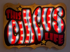
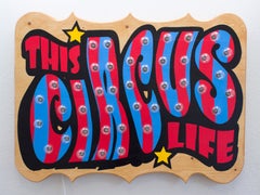
"This Circus Life" FULLY FUNCTIONAL MARQUEE LIGHT SIGN.
Located in San Antonio, TX
Samuel Wilson (Born 1986) San Antonio, TX Image Size: 27 X 36 Medium: Wood, Paint, Lights "This Circus Life" Born in 1986 in Wicihta, KS, Sam is a self taught artist, growing up ar...
Wood, Lights, House Paint
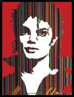
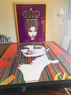
King of Pop I (Limited Edition Print)
Located in LOS ANGELES, CA
**ANNUAL SUPER SALE UNTIL FEB 29tH ONLY** THIS PRICE WON'T BE REPEATED AGAIN THIS YEAR - TAKE ADVANTAGE OF IT** Celebrating the King of Pop Michael Jackso...
Cotton Canvas, Giclée


Phenol Red
Located in Phoenix, AZ
stainless steel, vinyl emulsion
Stainless Steel