
Geological Map

to
14
54
31
42
26
19
15
14
14
10
7
7
5
4
3
2
2
2
2
2
1
1
1
1
1
1
1
1
36
3
2
2
2
Sort By
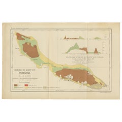
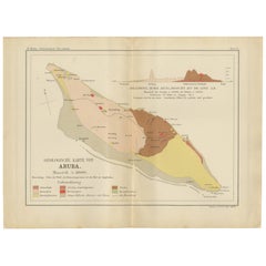
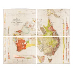
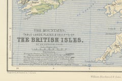
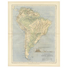
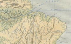
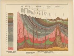
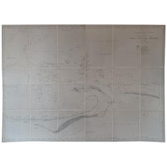
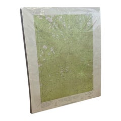
Antique Geological Map of the World by Johnston '1850'
Located in Langweer, NL
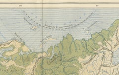
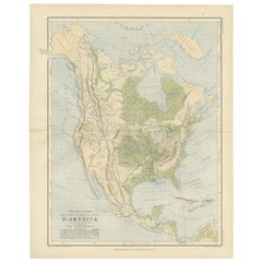
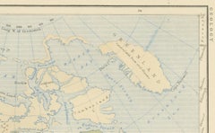
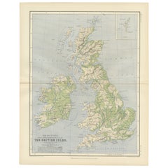
Antique map titled 'The Geological Structure of the Globe'. Original antique geological map of the
Category

Antique Mid-19th Century Maps

Materials

Paper

Antique Geological Map of Curaçao - Hand Colored Dutch Caribbean, 1888
Located in Langweer, NL
Geological Map of Curaçao 1888 Dutch West Indies by Karl Martin This exceptionally detailed
Category

Antique 1880s German Maps

Materials

Paper

Geological Map of Bonaire - Dutch West Indies by Karl Martin, 1888
Located in Langweer, NL
Geological Map of Bonaire 1888 Dutch West Indies by Karl Martin This finely executed geological
Category

Antique 1880s German Maps

Materials

Paper

Large Topographical and Geological Map of the Teshio Oil Field, '1936'
Located in Langweer, NL
Topographical and geological map of the Teshio oil field. Shows location of oil well, oil sand
Category

20th Century Maps

Materials

Linen, Paper

Antique Geological Map of Aruba - Dutch West Indies by Karl Martin, 1888
Located in Langweer, NL
Geological Map of Aruba 1888 Dutch West Indies by Karl Martin This finely detailed geological map
Category

Antique 1880s German Maps

Materials

Paper

Impressive Geological Map of Australia – Rare Oversized Wall Display, 1931–32
Located in Langweer, NL
Geological Map of the Commonwealth of Australia by Sir Edgeworth David, 1931–32 Large and highly
Category

Early 20th Century Australian Maps

Materials

Linen, Paper

Antique Map of Wisconsin with Inset Geological Map of Wisconsin
Located in Langweer, NL
geological map of Wisconsin. This print originates from 'Encyclopaedia Britannica', Ninth Edition. Published
Category

Antique Late 19th Century Maps

Materials

Paper

Geological Map of Europe by A.K. Johnston – Mountains and Valleys 1852
Located in Langweer, NL
Geological Map of Europe by A.K. Johnston – Mountains and Valleys 1852 This elegant 1852 map
Category

Antique Mid-19th Century Scottish Prints

Materials

Paper

Geological Map of Africa by A.K. Johnston – Mountains and Valleys 1852
Located in Langweer, NL
Geological Map of Africa by A.K. Johnston – Mountains and Valleys 1852 This antique map titled
Category

Antique Mid-19th Century Scottish Prints

Materials

Paper

Geological Map of Asia by A.K. Johnston – Mountains and Valleys 1852
Located in Langweer, NL
Geological Map of Asia by A.K. Johnston – Mountains and Valleys 1852 This finely engraved and hand
Category

Antique Mid-19th Century Scottish Prints

Materials

Paper

Geological Map of North America by A.K. Johnston – Mountains and Valleys 1852
Located in Langweer, NL
Geological Map of North America by A.K. Johnston – Mountains and Valleys 1852 This finely detailed
Category

Antique Mid-19th Century Scottish Prints

Materials

Paper

Geological Map of the British Isles by A.K. Johnston – Highlands & Valleys 1852
Located in Langweer, NL
Geological Map of the British Isles by A.K. Johnston – Highlands & Valleys 1852 This antique
Category

Antique Mid-19th Century Scottish Prints

Materials

Paper

Geological Map of South America by A.K. Johnston – Mountains and Valleys 1852
Located in Langweer, NL
Geological Map of South America by A.K. Johnston – Mountains and Valleys 1852 This antique map
Category

Antique Mid-19th Century Scottish Prints

Materials

Paper

Antique Map of the Region of Wakayama, Nara and Osaka 'Japan', ca.1880
Located in Langweer, NL
Geological folding map of the area with Wakayama, Nara, Osaka, Mie, and Shiga in Japan, circa 1880
Category

Antique Late 19th Century Maps

Materials

Linen, Paper

Antique Geological Survey Map of Surinam 1888 Hand Colored, Rare
Located in Langweer, NL
Antique Geological Survey Map of Surinam 1888 Hand Colored This impressive hand-colored geological
Category

Antique 1880s German Maps

Materials

Paper

"Atlas to Accompany Monograph XXXII on the Geology of Yellowstone National Park"
By United States Geological Survey
Located in Colorado Springs, CO
the topography and geology of Yellowstone, and the following maps: Gallatin Sheet, Topography
Category

Antique Early 1900s American Maps

Materials

Leather, Fabric, Paper

Vintage "Colorado, Crested Butte Sheet" USGS Topographical Map, 20th Century
By United States Geological Survey
Located in Colorado Springs, CO
United States Geological Survey. Highly detailed, the map captures the rugged topography of Gunnison
Category

20th Century American Maps

Materials

Paper

Decorative Antique Geological Cross-Sections – Earth & Mountains, c.1880
Located in Langweer, NL
Antique Geological Cross-Sections – Structure of the Earth & European Mountains, c.1880 This pair
Category

Antique Late 19th Century German Maps

Materials

Paper

Decorative Vintage Fossil Prints – Triassic Plants, Reptiles, Fish, Geology 1880
Located in Langweer, NL
Antique Fossil Prints – Triassic Plants, Reptiles & Fish with Geological Sections, c.1880 This
Category

Antique Late 19th Century German Maps

Materials

Paper

Tafra Island in Suriname - A Romantic River Landscape by Karl Martin, 1888
Located in Langweer, NL
Martin’s geological maps of Curaçao, Aruba, and Bonaire as part of a cohesive Dutch West Indies and Guiana
Category

Antique 1880s Dutch Maps

Materials

Paper

Aruba Landscape & Mountain Views - Dutch West Indies by Karl Martin, 1888
Located in Langweer, NL
pairs exceptionally well with Martin’s geological maps of Aruba, Curaçao, and Bonaire as part of a
Category

Antique 1880s Dutch Maps

Materials

Paper

Suriname Indigenous People & Tribal Objects - Ethnographic Lithographs 1888
Located in Langweer, NL
exceptionally well with Martin’s Suriname landscapes, Tafra Island view, and ABC Islands geological maps as part
Category

Antique 1880s Dutch Maps

Materials

Paper

Large Antique Map of the East Indies by Brouwer, 1917
Located in Langweer, NL
geological overview of this region. As a geotectonic map, it details the geological structure and plate
Category

Early 20th Century Dutch Maps

Materials

Canvas, Paper

Map of the Volcano Islands of Santorini – Antique Engraving by Portier, ca.1790
Located in Langweer, NL
volcanic activity, making it an appealing piece for collectors of antique maps, geological history, or
Category

Antique Late 18th Century French Maps

Materials

Paper

ELDRIDGE – Custom Handmade Rug by Rugs & Co.
Located in Herzliya, IL
cream twist into themselves, as if born from a geological map of a stratified city. The rug is handwoven
Category

21st Century and Contemporary Indian Modern Western European Rugs

Materials

Silk

ELDRIDGE – Custom Handmade Rug by Rugs & Co.
$3,243 Sale Price / item
20% Off
Christo and Jeanne-Claude and Christo Signed in Christo in Crayon Lithograph
By Christo and Jeanne-Claude
Located in Chicago, IL
panels and the geological map. Includes frame.
Category

1990s North American Organic Modern Contemporary Art

Materials

Paper

Vintage Central Oregon Geological Topographical State Map.Circa 1955.
Located in Seattle, WA
This Map was made by the US Department of the Interior as a Geological Survey. Green background
Category

Vintage 1950s Mid-Century Modern Contemporary Art

Materials

Paper

Single Slab Black Walnut Live Edge Dining Table - One Piece Wood Table
Located in İnegöl, TR
single, continuous piece of solid wood, prized for its uninterrupted grain that flows like a geological
Category

2010s Turkish Organic Modern Dining Room Tables

Materials

Epoxy Resin, Wood, Walnut

Rare Single Slab Black Walnut Live Edge Dining Table, A Monolithic Centerpiece
Located in İnegöl, TR
grain that flows like a geological map across the entire surface. The rich, chocolate tones and complex
Category

2010s Turkish Organic Modern Dining Room Tables

Materials

Epoxy Resin, Wood, Walnut

Rare Single Slab Black Walnut Live Edge Dining Table with a Clear Epoxy River
Located in İnegöl, TR
a geological map across the entire surface. The rich, chocolate tones and complex figuring tell a
Category

2010s Turkish Arts and Crafts Dining Room Tables

Materials

Epoxy Resin, Wood, Walnut

1941 original map "Les vins de Bordeaux - Médoc, Haut-Médoc" by Larmat
Located in PARIS, FR
of the region are prominently marked on the map, as these geological features are key to the
Category

1940s Prints and Multiples

Materials

Paper, Lithograph

Spine, abstract etching in gold and brown by Rosalyn Richards
By Rosalyn Richards
Located in Palm Springs, CA
particle physics, satellite photography, biotechnology, radiology, geological survey maps, have all served
Category

21st Century and Contemporary Abstract Abstract Prints

Materials

Aquatint, Etching

Mirage
By Rosalyn Richards
Located in Palm Springs, CA
, biotechnology, radiology, geological survey maps, have all served as influences on Richards' work. Her paintings
Category

2010s Abstract Abstract Prints

Materials

Etching, Aquatint

Fire, etching and aquatint by Rosalyn Richards
By Rosalyn Richards
Located in Palm Springs, CA
, biotechnology, radiology, geological survey maps, have all served as influences on Richards' work. Her paintings
Category

21st Century and Contemporary Abstract Abstract Prints

Materials

Etching, Aquatint

Circulation, by Rosalyn Richards
By Rosalyn Richards
Located in Palm Springs, CA
, radiology, geological survey maps, have all served as influences on Richards' work. Her paintings, prints
Category

21st Century and Contemporary Abstract Abstract Prints

Materials

Etching, Aquatint

Satellite, by Rosalyn Richards
By Rosalyn Richards
Located in Palm Springs, CA
, geological survey maps, have all served as influences on Richards' work. Her paintings, prints, and drawings
Category

21st Century and Contemporary Abstract Abstract Prints

Materials

Etching, Aquatint

Past Light, by Rosalyn Richards
By Rosalyn Richards
Located in Palm Springs, CA
, satellite photography, biotechnology, radiology, geological survey maps, have all served as influences on
Category

Early 2000s Contemporary Abstract Prints

Materials

Etching, Aquatint

Torn Veil, by Rosalyn Richards
By Rosalyn Richards
Located in Palm Springs, CA
, radiology, geological survey maps, have all served as influences on Richards' work. Her paintings, prints
Category

21st Century and Contemporary Abstract Abstract Prints

Materials

Etching, Aquatint

Mirror Pool, by Rosalyn Richards
By Rosalyn Richards
Located in Palm Springs, CA
, radiology, geological survey maps, have all served as influences on Richards' work. Her paintings, prints
Category

Early 2000s Abstract Abstract Prints

Materials

Etching, Aquatint

Remote Sensing, by Rosalyn Richards
By Rosalyn Richards
Located in Palm Springs, CA
Images from particle physics, satellite photography, biotechnology, radiology, and geological survey maps
Category

21st Century and Contemporary Abstract Abstract Prints

Materials

Etching, Aquatint

Correlations, by Rosalyn Richards
By Rosalyn Richards
Located in Palm Springs, CA
, radiology, geological survey maps, have all served as influences on Richards' work. Her paintings, prints
Category

Early 2000s Abstract Abstract Prints

Materials

Etching, Aquatint

Beacon, by Rosalyn Richards
By Rosalyn Richards
Located in Palm Springs, CA
photography, biotechnology, radiology, geological survey maps, have all served as influences on Richards' work
Category

2010s Abstract Abstract Prints

Materials

Etching, Aquatint

Harmonics, by Rosalyn Richards
By Rosalyn Richards
Located in Palm Springs, CA
particle physics, satellite photography, biotechnology, radiology, geological survey maps, have all served
Category

21st Century and Contemporary Abstract Abstract Prints

Materials

Etching, Aquatint

Strange Alchemy, by Rosalyn Richards
By Rosalyn Richards
Located in Palm Springs, CA
photography, biotechnology, radiology, geological survey maps, have all served as influences on Richards' work
Category

Early 2000s Contemporary Abstract Prints

Materials

Etching, Aquatint

Dispersion, by Rosalyn Richards
By Rosalyn Richards
Located in Palm Springs, CA
photography, biotechnology, radiology, geological survey maps, have all served as influences on Richards' work
Category

Early 2000s Contemporary Abstract Prints

Materials

Etching, Aquatint

Flame, by Rosalyn Richards
By Rosalyn Richards
Located in Palm Springs, CA
photography, biotechnology, radiology, geological survey maps, have all served as influences on Richards' work
Category

Early 2000s Abstract Abstract Prints

Materials

Etching, Aquatint

Atmospheric River, abstract print by Rosalyn Richards
By Rosalyn Richards
Located in Palm Springs, CA
. Images from particle physics, satellite photography, biotechnology, radiology, geological survey maps
Category

2010s Abstract Abstract Prints

Materials

Etching, Aquatint

Orbits, by Rosalyn Richards
By Rosalyn Richards
Located in Palm Springs, CA
. Images from particle physics, satellite photography, biotechnology, radiology, geological survey maps
Category

21st Century and Contemporary Abstract Abstract Prints

Materials

Etching, Aquatint

Floating Habitat, by Rosalyn Richards
By Rosalyn Richards
Located in Palm Springs, CA
, geological survey maps, have all served as influences on Richards' work. Her paintings, prints, and drawings
Category

21st Century and Contemporary Abstract Abstract Prints

Materials

Etching, Aquatint

Time Travel, by Rosalyn RIchards
By Rosalyn Richards
Located in Palm Springs, CA
physics, satellite photography, biotechnology, radiology, geological survey maps, have all served as
Category

Early 2000s Abstract Abstract Prints

Materials

Etching, Aquatint

Ebb and Flow, by Rosalyn RIchards
By Rosalyn Richards
Located in Palm Springs, CA
, biotechnology, radiology, geological survey maps, have all served as influences on Richards' work. Her paintings
Category

2010s Abstract Abstract Prints

Materials

Etching, Aquatint

Ascending, etching by Rosalyn Richards
By Rosalyn Richards
Located in Palm Springs, CA
, biotechnology, radiology, geological survey maps, have all served as influences on Richards' work. Her paintings
Category

2010s Abstract Abstract Prints

Materials

Etching, Aquatint

Report upon the Colorado River of the West by Joseph Ives, First Edition, 1861
Located in Colorado Springs, CO
without the two additional maps with added geological information, which were not issued in all copies and
Category

Antique 1860s American Books

Materials

Fabric, Paper

Rain On Ferns, by Rosalyn Richards
By Rosalyn Richards
Located in Palm Springs, CA
since 1982. Images from particle physics, satellite photography, biotechnology, radiology, geological
Category

21st Century and Contemporary Abstract Abstract Prints

Materials

Etching, Aquatint

Storm, abstract landscape by Rosalyn Richards
By Rosalyn Richards
Located in Palm Springs, CA
, biotechnology, radiology, geological survey maps, have all served as influences on Richards' work. Her paintings
Category

21st Century and Contemporary Abstract Abstract Prints

Materials

Etching, Aquatint

Secret Messenger, by Rosalyn Richards
By Rosalyn Richards
Located in Palm Springs, CA
photography, biotechnology, radiology, geological survey maps, have all served as influences on Richards' work
Category

Early 2000s Abstract Abstract Prints

Materials

Etching, Aquatint

Collision
By Rosalyn Richards
Located in Palm Springs, CA
photography, biotechnology, radiology, geological survey maps, have all served as influences on Richards' work
Category

Early 2000s Abstract Abstract Prints

Materials

Etching, Aquatint

  • 1
Get Updated with New Arrivals
Save "Geological Map", and we’ll notify you when there are new listings in this category.

Geological Map For Sale on 1stDibs

With a vast inventory of beautiful furniture at 1stDibs, we’ve got just the geological map you’re looking for. Frequently made of paper, fabric and linen, every geological map was constructed with great care. There are many kinds of the geological map you’re looking for, from those produced as long ago as the 19th Century to those made as recently as the 20th Century. Each geological map bearing Victorian or Mid-Century Modern hallmarks is very popular. You’ll likely find more than one geological map that is appealing in its simplicity, but William W. Mather and United States Geological Survey produced versions that are worth a look.

How Much is a Geological Map?

Prices for a geological map start at $295 and top out at $9,500 with the average selling for $1,459.