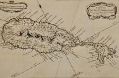
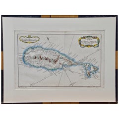
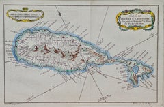
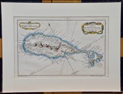
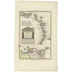
St Eustatius
St. Christophe (St. Kitts): Bellin 18th Century Hand Colored Map
Located in Alamo, CA
l'Isle St. Christophe Pour servir á l'Histoire Genle. des Voyages Par M. B. Ingr. de la Marine
Category
1740s Other Art Style Landscape Prints
Materials
Engraving
St. Christophe 'St. Kitts' Island: An 18th Century Hand-colored Map by Bellin
By Jacques-Nicolas Bellin
Located in Alamo, CA
l'Isle St. Christophe Pour servir á l'Histoire Genle. des Voyages Par M. B. Ingr. de la Marine
Category
Antique Mid-18th Century French Maps
Materials
Paper
$575
H 10 in W 14.25 in D 0.07 in
Recent Sales
Bellin 18th Century Hand Colored Map of St. Christophe (St. Kitts)
By Jacques-Nicolas Bellin
Located in Alamo, CA
located to the south-east and the Dutch island of St. Eustatius is to the north-west. It was originally
Category
Antique Mid-18th Century French Maps
Materials
Paper
Bellin 18th Century Hand Colored Map of St. Christophe (St. Kitts)
Located in Alamo, CA
located to the south-east and the Dutch island of St. Eustatius is to the north-west. It was originally
Category
Late 18th Century Other Art Style Landscape Prints
Materials
Engraving
H 13.13 in W 17 in D 0.75 in
Antique Map of the Dutch Antilles 'Caribbean' by R. Bonne, circa 1780
Located in Langweer, NL
. This region typically includes islands such as Aruba, Bonaire, Curacao, Saba, St. Eustatius, and St
Category
Antique Late 18th Century Maps
Materials
Paper
H 18.19 in W 11.03 in D 0.02 in
Get Updated with New Arrivals
Save "St Eustatius", and we’ll notify you when there are new listings in this category.