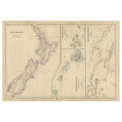
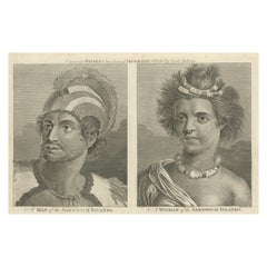
New Zealand, Antique Map, Pacific Islands, Sandwich Islands, Blackie Atlas 1860
Description:
This original antique map titled New Zealand presents a detailed mid-19th-century view of New Zealand, accompanied by inset maps of the Sandwich Islands (Hawaii), the Galapagos Islands, and the Papuan Archipelago. It originates from The Imperial Atlas of Modern Geography and was published in 1860 by W. G. Blackie, one of the most respected British atlas publishers of the period.
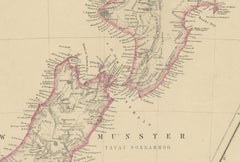
The main map depicts both the North and South Islands of New Zealand with finely engraved coastal outlines, mountain ranges, rivers, settlements, and regional divisions. Early place names and geographic features reflect contemporary European exploration and colonial knowledge, making the map an important historical document of New Zealand’s cartographic development during the 19th century.
To the right, the additional Pacific island groups are shown in separate panels, each carefully delineated and subtly hand-colored. These inset maps broaden the geographical scope of the sheet, illustrating Britain’s growing interest in the wider Pacific world. The restrained original hand coloring helps distinguish coastlines and island groups while maintaining a calm, elegant appearance.
The overall layout is balanced and visually engaging, combining dense geographic information with generous open areas of sea. This makes the map particularly attractive both as a collectible reference piece and as decorative wall art. Its horizontal format works well in interiors, especially for collectors or designers drawn to maritime history, exploration, and Pacific geography.
Condition report:
Good antique condition. Light overall age toning consistent with period. Minor scattered foxing and faint handling marks, primarily in the margins. Original central fold as issued. No major tears or losses.
Framing tips:
A wide ivory or warm cream mat will enhance the engraved detail and original coloring. A dark walnut, black, or understated antique gilt frame complements the map’s academic and exploratory character. Museum or UV-protective glass is recommended.
Technique: Copper engraving with original hand coloring
Maker: W. G. Blackie, Scotland, 1860
Keywords:
New Zealand map...
Category
Mid-19th Century British Antique John Webber Folk Art