18th Century and Earlier Collectibles and Curiosities

to
2,700
3,886
556
4,477
216
93
41
35
28
14
10
7
4
2
2
2
1
1
1
6,828
13,528
2,736
3,516
4,726
3,085
511
298
604
745
487
909
909
906
659
596
3,380
598
526
139
127
1,380
281
268
225
190
4,477
4,477
4,477
58
21
14
13
12
Period: 18th Century and Earlier
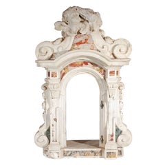
Baroque Period, Italian, Marble Tabernacle
Located in Los Angeles, CA
Fabulous, hand-carved and veneered, 1700's, solid marble tabernacle from an Italian church altar. The scrolling, side pillars are surmounted by a ...
Category

Italian Baroque Antique 18th Century and Earlier Collectibles and Curiosities

Materials

Marble

Bibliothecæ Alexandrinæ icones symbolicæ / elogiis illustratæ, by C. Giarda
Located in Middletown, NY
DISTINGUISHED PEDIGREE: from the libraries of Robert Hoe and John Barrymore. Elegantly illustrated and bound copy with a famed pedigree that spans from Robert Hoe—the businessman, collector, and founding member of the Grolier Club in 1884— to "The Lamberts" (probably purchased in the epic Hoe library auction of 1911-1912), who gifted it to the colorful and famous actor John Barrymore. Their bookplates adorn the inside covers, will your bookplate be next? Giarda, Cristoforo Bibliothecæ Alexandrinæ icones symbolicæ … elogiis illustratæ Milan: Giovanni Battista Bidelli, 1628. 4to, 9 5/8 x 7 inches (244 x 178 mm); (xii) + 140 pp, not including plates and inscriptions. Engraved architectural title with Saints Peter and Alexander by Cesare Bassano, 16 copperplates of female figures; woodcut dropcaps and tailpieces throughout. Later (circa 1890) red levant morocco binding by R. Petit (signed in gilt on front turn-in) with triple gilt frames on boards, raised bands, gilt title and decorative motifs in compartments; inner dentelles, marbled endpapers, professionally rebacked preserving original richly gilt backstrip in compartments; title and preliminaries stained, occasional spotting or light soiling and a few small light ink stains to covers. [Praz p.349] Provenance: Robert Hoe (blue morocco book label...
Category

French Antique 18th Century and Earlier Collectibles and Curiosities

Materials

Gold Leaf

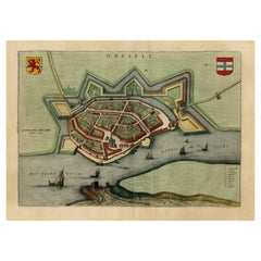
Stunning Bird's-Eye View Plan of Hasselt by Blaeu in The Netherlands, 1649
Located in Langweer, NL
Antique print, titled: 'Hasselt.' Bird's-eye view plan of Hasselt in The Netherlands. With key to locations and coats of arms. Text in Dutch on verso. This plan originates from the famous city Atlas: 'Toneel der Steeden' published by Joan Blaeu...
Category

Antique 18th Century and Earlier Collectibles and Curiosities

Materials

Paper

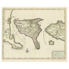
1726 Valentyn's Map of Bali and Lombok, Original Engraving
Located in Langweer, NL
This antique map is a detailed 18th-century chart of the island of Bali, one of the many islands of Indonesia, with an inset of the neighboring island Lombok, attributed to François ...
Category

Antique 18th Century and Earlier Collectibles and Curiosities

Materials

Paper

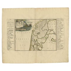
Antique Map of the West-Frisian part of independent Friesland by Halma, 1718
Located in Langweer, NL
Antique map Friesland titled 'ars I. Frisiae Liberae quae Westfresia post eluviones seculi XIII (..)'. Old map of the West-Frisian part of the independent Friesland, the Netherlands ...
Category

Antique 18th Century and Earlier Collectibles and Curiosities

Materials

Paper

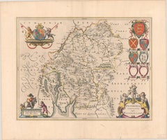
1645 Blaeu Map of Westmorland, Northern England – Hand Colored, Decorative
Located in Langweer, NL
This map, "Westmoria Comitatus; Anglice Westmorland", was created by the esteemed Dutch cartographer Willem Blaeu and was published around 1645 in 'Le Theatre du Monde ou Nouvel Atlas'. It provides a detailed look at Westmorland, a historic county in northern England, based on John Speed’s earlier map. The map features numerous place names, parks, and estates, including Brigster Park, Colnhead Park, Crosbye, and Midleton, along with a detailed depiction of Windermere (spelled Wynandermere) and the surrounding regions. Additional Features: - Hand-colored map, with vibrant and detailed colors that bring out the topographical and decorative features. - Includes intricate cartouches, such as the royal coat of arms, a decorative title cartouche topped with putti (cherubic figures), and six coats of arms (two left blank). - Depicts the region’s rich landscape, including the rolling hills and mountainous terrain of northern England. - French text on the verso, indicative of the publication period from 1645-1648, part of Blaeu’s highly sought-after atlases. - Map shows precise details of small towns, estates, and parks, such as Brigster Park, Colnhead Park, Crosbye, and Wynandermere (now Windermere Lake). This map would be of particular interest to collectors of English county maps, antique maps of northern England, 17th-century cartography, and the decorative works of Willem Blaeu. Blaeu's maps are renowned for their accuracy, artistic beauty, and historical significance. Keywords: Willem Blaeu, Westmorland map, northern England, 17th-century map, antique map, English county map, John Speed, Windermere, decorative cartography, hand-colored map, rare map, antique cartography...
Category

Dutch Antique 18th Century and Earlier Collectibles and Curiosities

Materials

Paper

Detailed 18th-Century Map of Paris and Its Surrounding Regions by Johann Homann
Located in Langweer, NL
This map, titled “Agri Parisiensis Tabula particularis,” was created and published by the German cartographer Johann Baptist Homann (1664–1724), or his workshop, in Nuremberg. Homann...
Category

Antique 18th Century and Earlier Collectibles and Curiosities

Materials

Paper

Balsamarium shaped as a Bust of a Black Boy - Roman, 1st – 2nd Century AD
Located in Bruxelles, BE
Balsamarium shaped as a Bust of a Black Boy Bronze, silver inlaid eyes and lips, Roman, 1st – 2nd Century AD Provenance: Private London Collection formed 1965-1975 H 10 cm (4 in...
Category

Italian Classical Roman Antique 18th Century and Earlier Collectibles and Curiosities

Materials

Silver, Bronze

Gallipoli Fortifications: A 1688 Engraved Bird’s-Eye Map by Mattheus Merian
Located in Langweer, NL
Gallipoli Fortifications: A 1688 Bird’s-Eye Map by Mattheus Merian Description: This exquisitely detailed map of Gallipoli, crafted by the renowned engraver Mattheus Merian, offers ...
Category

German Antique 18th Century and Earlier Collectibles and Curiosities

Materials

Paper

Decorative Original Antique Map of Valencia in Southern Spain, circa 1601
Located in Langweer, NL
This is an original antique map titled 'Valentiae Regni olim Contestanorum Si Ptolemaeo, Edentanorum Si Plinio Credimus Typus'. This is a historical map of the Kingdom of Valencia in...
Category

Antique 18th Century and Earlier Collectibles and Curiosities

Materials

Paper

Antique Map of the Middle East by Brion de la Tour '1772'
Located in Langweer, NL
Antique map titled 'Carte des Pays et Principaux Lieux (..)'. Original antique map of Middle East, extending to the Red Sea, Egypt, the Eastern Medi...
Category

Antique 18th Century and Earlier Collectibles and Curiosities

Materials

Paper

Crown or Crest, Pinewood, 17th Century
Located in Madrid, ES
Top or top made of pine wood carved in color with a human bust in the center, located by grabbing two scrolls and thus creating an axis of symmetry for the...
Category

European Baroque Antique 18th Century and Earlier Collectibles and Curiosities

Materials

Pine

Old Map of Guyana, Suriname and French Guiana with Paramaribo and Cayenne, c1760
Located in Langweer, NL
Description: Antique map titled 'Carte de la Guiane.' Antique map of the Guianas - present day Guyana, Suriname and French Guiana, including Paramaribo and Cayenne. Source unknown, to be determined. Artists and Engravers: Made by 'Jacques-Nicholas Bellin...
Category

Antique 18th Century and Earlier Collectibles and Curiosities

Materials

Paper

Antique Map of the Bay of Manila, Capital of the Philippines
Located in Langweer, NL
Antique map titled 'Abzeichnung des Meerbusens bey Manila'. Map of the Bay of Manila, capital of the Philippines. This map originates from a German edition of 'Voyage around the World...
Category

Antique 18th Century and Earlier Collectibles and Curiosities

Materials

Paper

Reliquary Bronze Crucifix Pendant with Two Lateral Crosses, Italy, 17th Century
Located in Frankfurt am Main, DE
A reliquary bronze crucifix on large engraved cross pendant with two hanging small crosses at both lateral sides of the large cross, Italy, early 17th century. Both small crosses wit...
Category

Italian Gothic Revival Antique 18th Century and Earlier Collectibles and Curiosities

Materials

Bronze

Rare George III Celestial Pocket Globe by Cary, London
By Cary
Located in Oxfordshire, United Kingdom
A fine and rare 3" celestial pocket globe by G & W Cary, Strand, London circa 1791, housed in its original sharkskin case. A companion globe to terrestrial globes of this type we...
Category

English George III Antique 18th Century and Earlier Collectibles and Curiosities

Materials

Plaster

Map of the Region of Basel and Northern Switzerland by Ortelius, circa 1603
Located in Langweer, NL
Two original antique maps on one sheet titled 'Basiliensis Territorii Descriptio Nova [with] Circulus sive Liga Sueviae'. The first centers on Basel, Switzerland, located on the Rhine River...
Category

Antique 18th Century and Earlier Collectibles and Curiosities

Materials

Paper

Giltwood Niche. Rococo, 18th Century
Located in Madrid, ES
Hornacina formed by a back decorated with molding and a support for a sculpture decorated with a masque and vegetal motifs and topped by a split pediment with a central motif worked ...
Category

European Rococo Antique 18th Century and Earlier Collectibles and Curiosities

Materials

Wood

Antique Architecture Print of a Composite Portico by Neufforge, c.1770
Located in Langweer, NL
Antique print titled 'Plan et Elevation d'un Portique Composite (..)'. Old print showing the design of a Composite portico. This print originates from 'Recueil Élémentaire d?Architec...
Category

Antique 18th Century and Earlier Collectibles and Curiosities

Materials

Paper

Dutch City Plan of Workum in Friesland by N. Van Geelkercken, hand-colored 1616
Located in Langweer, NL
Workum in Friesland by Nicolaes van Geelkercken, hand-colored map ca. 1616 This beautifully hand-colored engraving titled 'Worcum' presents an early 17th-century bird’s-eye view of ...
Category

Dutch Antique 18th Century and Earlier Collectibles and Curiosities

Materials

Paper

A Dutch West India Company GWC almanack for the year 1760
Located in Amsterdam, NL
"D'Erven Stichter’s Comptoir Almanach, Op ’t Schrikkel-Jaar onzes Heeren Jesu Christi, 1760, voorzien met alle de Jaar-, Paarden-, Beesten-, en Leermarkten Alsmede de Vacantien, het ...
Category

Dutch Antique 18th Century and Earlier Collectibles and Curiosities

Materials

Leather, Paper

Ancient Babylon with The Tower of Babel According to Herodotus & Kircherus, 1730
Located in Langweer, NL
Antique print titled 'Platte Grond van de Stad Babilon, volgens Herodotus en A. Kircherus'. This original antique print shows a view of ancient Babylon with the tower of Babel...
Category

Antique 18th Century and Earlier Collectibles and Curiosities

Materials

Paper

Early 17th Century Sculpture
Located in Copenhagen, K
Amazing Baroque sculpture of a woman wearing a crown in original paint. Her hands are missing. Colors are untouched, recently cleaned off from a thick dark coating, I have images fro...
Category

French Baroque Antique 18th Century and Earlier Collectibles and Curiosities

Materials

Oak

Antique Engraved Map of the Northern Part of Greece and the Aegean Sea, Ca.1730
Located in Langweer, NL
Title: "GRÆCIÆ PARS Septentrionalis". Hand Coloured Engraved map by G. Delisle of the northern part of the Aegean. In the top left corner a distance scale included. Condition...
Category

Antique 18th Century and Earlier Collectibles and Curiosities

Materials

Paper

Antique Map of Trincomalee and Tambalagam Bay, 1758
Located in Langweer, NL
Antique map titled 'Bay de Trinquemale'. Map of Trincomalee and Tambalagam Bay in Sri Lanka. While these maps by Van Schley after Bellin were initially made for 'Histoire Generale de...
Category

Antique 18th Century and Earlier Collectibles and Curiosities

Materials

Paper

Antique Map of Italy by R. Bonne, circa 1780
Located in Langweer, NL
Beautiful map of Italy, Corsica, Sardinia and Sicily. Highly detailed, showing towns, rivers, some topographical features and political boundaries. Published by R. Bonne, circa 1780.
Category

French Antique 18th Century and Earlier Collectibles and Curiosities

Materials

Paper

Original Antique Plan of the Fortress of Charedsch in Persia or Iran, ca.1780
Located in Langweer, NL
Antique map, titled: 'Plan de la Citadelle de la Ville de Charedsch.' Plan of the fortress of Charedsch, Iran / Persia. This original antique print originates from 'Reize naar Ar...
Category

Antique 18th Century and Earlier Collectibles and Curiosities

Materials

Paper

Rare and Interesting Small Antique Woodcut Map of the Mediterranean, 1568
Located in Langweer, NL
Very rare untitled antique woodcut map showing the region of the missionary journeys of Apostle Paul. It shows the Mediterranean with Greece, Asia Minor (Turkey), Northern Africa, So...
Category

Antique 18th Century and Earlier Collectibles and Curiosities

Materials

Paper

1667 Melchior Tavernier Map of the Patriarchate of Constantinople – Black Sea
Located in Langweer, NL
This 1667 map titled "Patriarchatus Constantinopolitani Geographica Descriptio" was crafted by renowned French cartographer Melchior Tavernier, who was a prominent map engraver during the 17th century. This rare and historically significant map focuses on the territories under the ecclesiastical jurisdiction of the Patriarchate of Constantinople, one of the most important centers of the Eastern Orthodox Church. It covers regions around the Black Sea (Pontus Euxinus), parts of Greece, and adjacent areas in Asia Minor and the Balkans, which were historically vital during the Byzantine and Ottoman Empires. The map is filled with ancient place names, making it a valuable resource for both historical and cartographic enthusiasts. Key Features: - Antique ecclesiastical map illustrating the influence of the Orthodox Patriarchate of Constantinople in the 17th century. - Features beautifully detailed ancient coastlines, rivers, and terrains, providing a comprehensive geographical view of the region. - Rich with historic place names - like Byzantium, Nicomedia, Nicaea, Cyzicus, Bithynia, Pontus, Macedonia, and Thrace - that date back to the classical era, offering insights into the ancient geography of the eastern Mediterranean. - A finely engraved strapwork cartouche in the lower right corner with Baroque-style decoration, featuring two putti (cherubic figures) – a hallmark of 17th-century map art. - The map extends to include the Mediterranean Sea (Mare Mediterraneum) to the south and the Black Sea to the north, highlighting its ecclesiastical and geopolitical significance. - Original hand coloring may still be present, enhancing the decorative appeal for collectors of antique maps. This rare map offers a unique perspective on the religious influence and historical geography of the Eastern Mediterranean during the late 17th century. It would appeal to collectors interested in: - **Byzantine history** - **Ottoman Empire** - **Eastern Orthodox Church** - **Antique cartography...
Category

French Antique 18th Century and Earlier Collectibles and Curiosities

Materials

Paper

Original Detailed Antique Map of Southern India and Most of Ceylon, 1744
Located in Langweer, NL
Antique map titled 'A Map of India on the west Side of the Ganges, comprehending the coasts of Malabar, Coromandel and the Island Ceylon'. Map of Southern India and most of Ceylo...
Category

Antique 18th Century and Earlier Collectibles and Curiosities

Materials

Paper

Antique Map of Africa with Original Hand Coloring
Located in Langweer, NL
Antique map titled 'Kaart van Afrika door den Heer d'Anville'. Detailed original old map of Africa, with very small inset map titled 'Vlaamsche Eilanden', which shows the Azores. Pub...
Category

Antique 18th Century and Earlier Collectibles and Curiosities

Materials

Paper

Dutch Delft Tobacco Jar: Straasburger, 18th Century
Located in AMSTERDAM, NH
Origin: Delft Date: Second half of the 18th century Workshop unknown A genuine blue and white tobacco jar for the storage of tobacco. The brand name: Straasburger, is painted in a...
Category

Dutch Rococo Antique 18th Century and Earlier Collectibles and Curiosities

Materials

Ceramic, Delft, Faience

Dutch City Plan of Sloten in Friesland by N. Van Geelkercken, hand-colored 1616
Located in Langweer, NL
Bird’s-Eye View of Sloten in Friesland by Nicolaes van Geelkercken, ca. 1616 This captivating hand-colored engraving presents an early 17th-century bird’s-eye view of the fortified ...
Category

Dutch Antique 18th Century and Earlier Collectibles and Curiosities

Materials

Paper

1584 Ortelius Map of Switzerland: A Cartographic Reversal
Located in Langweer, NL
This is a fine example of Ortelius' map of Switzerland from his *Theatrum Orbis Terrarum*, recognized as the first modern atlas of the world. The map is oriented with south at the top, which reverses the typical north-up orientation seen in most modern maps. It highlights significant geographical features such as Lake Geneva (Lemanus Lacus) to the right of the map and the Rhine river entering Switzerland near the center. The *Theatrum Orbis Terrarum*, first published in 1570 by Abraham Ortelius in Antwerp, was groundbreaking as it compiled uniform maps with supporting text in a single volume, marking a departure from earlier collections of maps that were custom-assembled on demand. This atlas included a wealth of sixteenth-century cartographic knowledge, reflecting the extensive global explorations occurring after the discovery of America...
Category

Antique 18th Century and Earlier Collectibles and Curiosities

Materials

Paper

Antique Map of the Bay of Bantam, c.1720
Located in Langweer, NL
Rare, untitled miniature map of the Bay of Bantam with various Islands including Pulo Dua and Pulo Batto. This map originates from a small travelogue and may originate from an editio...
Category

Antique 18th Century and Earlier Collectibles and Curiosities

Materials

Paper

5 Vol. James Bruce Kinnaird Esq., Travels to Discover the Source of The Nile
Located in New York, NY
5 Vol. James Bruce Kinnaird Esq. F. R. S., Travels to Discover the Source of The Nile. First Edition. Illustrated with 3 large folding maps and 58 plates. Deep red calf bound. Marble...
Category

English Antique 18th Century and Earlier Collectibles and Curiosities

Materials

Leather

Germany and the Borders of Empire: Bodenehr’s Map of the Holy Roman World, 1710
Located in Langweer, NL
Title: Germany and Surrounding Realms by Gabriel Bodenehr, circa 1710 This striking copperplate engraving, titled "S. Imperium Romano-Germanicum, Teutschland mit Seinen Angräntzende...
Category

Antique 18th Century and Earlier Collectibles and Curiosities

Materials

Paper

Venetian Trade Routes in the Levant – Antique Map by Pieter van der Aa, ca.1720
Located in Langweer, NL
Venetian Trade Routes in the Levant – Antique Map by Pieter van der Aa, Early 18th Century This finely engraved map, published by Pieter van der Aa in Leiden, provides a detailed d...
Category

Antique 18th Century and Earlier Collectibles and Curiosities

Materials

Paper

Map of the Persian Empire by Nicolas Sanson, Hand-colored, circa 1683
Located in Langweer, NL
Map of the Persian Empire by Nicolas Sanson, hand-colored, circa 1683 This finely detailed and delicately hand-colored map titled *L'Empire du Sophy des Perses* presents a late 17th...
Category

Antique 18th Century and Earlier Collectibles and Curiosities

Materials

Paper

Antique Map of the Maine Region by Janssonius, 1657
Located in Langweer, NL
Antique map of France titled 'Diocese du Mans vulgo le Mains'. Decorative map of the region of Maine, France. This map originates from 'Atlas Novus, Sive Theatrum Orbis Orbis Terraru...
Category

Antique 18th Century and Earlier Collectibles and Curiosities

Materials

Paper

Antique Map of Saxony and Westphalia by Scherer, 1699
Located in Langweer, NL
Antique map titled 'Saxonia et Westphalia varijs in locis sacris erga dei matre est officiosa & ipsa vicissim erga utramq. Munifica.' Detailed uncommon map of Saxony and Westphalia i...
Category

Antique 18th Century and Earlier Collectibles and Curiosities

Materials

Paper

Map of Le Maine by H. Hondius, 1633, Hand-Colored, Decorative and Historic
Located in Langweer, NL
Map of Le Maine by H. Hondius, 1633, Hand-Colored, Decorative and Historic This rare and beautifully executed antique map titled 'Le Maine' was published in 1633 by Henricus Hondius...
Category

Antique 18th Century and Earlier Collectibles and Curiosities

Materials

Paper

18th Century German Salt Glaze Tobacco Jar with Pewter Mounts
Located in Stamford, CT
A fine example of a German Baroque tobacco jar with original pewter lid. The rich ocher salt glaze decorated with raised floral motifs. A handsome addition for the collector of pipes...
Category

German Baroque Antique 18th Century and Earlier Collectibles and Curiosities

Materials

Stoneware

Antique Map of Spain & Portugal 'Iberian Peninsula', Decorative Cartouche, c1755
Located in Langweer, NL
Antique map titled 'Spain and Portugal'. Small, detailed antique map of Spain and Portugal (Iberian Peninsula). Decorative title cartouche. Artists and Engravers: Thomas Jeff...
Category

Antique 18th Century and Earlier Collectibles and Curiosities

Materials

Paper

Lot of 18 Antique French Methodical Encyclopedias
Located in Mckinney, TX
A wonderful collection of antique tattered French books discovered in France, representing The Encyclopédie méthodique par ordre des matières ("Methodical Encyclopedia by Order of Su...
Category

French Antique 18th Century and Earlier Collectibles and Curiosities

Materials

Paper

17th Century Spanish Talavera Pharmacy Jar in Blue Glazed Ceramic
Located in Marbella, ES
17th century Spanish Talavera pharmacy jar in blue glazed ceramic.
Category

Spanish Antique 18th Century and Earlier Collectibles and Curiosities

Materials

Ceramic

Hibernia Regnum Map by Carel Allard, 1700: Hand-Colored Provinces of Ireland
Located in Langweer, NL
This is a historical map of Ireland created by Carel Allard around 1700, titled "Hibernia Regnum in Quatuor Provincias Ultoniam, Connaciam, Lageniam, et Momoniam". The map is hand-colored and engraved. It includes two large decorative cartouches. The map is part of an atlas by Carel Allard, an Amsterdam-based cartographer. Here are the detailed points about the map: Maker: Carel Allard - a prominent Dutch cartographer and publisher from Amsterdam. Atlas: Source Atlas - Likely part of an atlas published by Carel Allard, but specific title of the atlas isn't mentioned. Interesting Features 1. Decorative Cartouches: The map features two large, ornate cartouches. One in the upper left depicts a classical figure and British Royal arms...
Category

Antique 18th Century and Earlier Collectibles and Curiosities

Materials

Paper

Antique Map of Warwickshire by Speed, c.1614
Located in Langweer, NL
Antique map titled 'The Counti of Warwick (..)'. Map of Warwickshire, England. Includes inset town plans of Warwick and Coventry. This map originates from 'Theatre of Great Britaine'...
Category

Antique 18th Century and Earlier Collectibles and Curiosities

Materials

Paper

Antique Print of the Dutch VOC Bombing Palembang, Sumatra (Indonesia), ca.1700
Located in Langweer, NL
Antique print titled 'La Ville de Palimbang dans L’Ile de Sumatra.' A very decorative, impressive engraving of Palembang in Sumatra. Two views on one sheet. In the upper part the ove...
Category

Antique 18th Century and Earlier Collectibles and Curiosities

Materials

Paper

Gascogne and Guyenne Map - Hand-Colored 17th-Century Engraving by De Wit, c.1688
Located in Langweer, NL
Title: Gascogne and Guyenne Map - Hand-Colored 17th-Century Engraving by Frederik De Wit c. 1688 Description: This remarkable map, "Gouvernement de la Guyenne & Gascogne," captures ...
Category

Antique 18th Century and Earlier Collectibles and Curiosities

Materials

Paper

1718 Ides & Witsen Map "Route D'amsterdam a Moscow Et De La Ispahan Et Gamron
Located in Norton, MA
1718 Ides & Witsen map, entitled "Route D'Amsterdam A Moscow Et De La Ispahan Et Gamron," Ric.b005 Subject: Eastern Europe and Central Asia Period: 1718 (published) Publicati...
Category

Dutch Antique 18th Century and Earlier Collectibles and Curiosities

Materials

Paper

Attractive Detailed Map of the Empire of the Great Mogul, Incl India, 1731
Located in Langweer, NL
Antique map titled 'Nieuwe Kaart van t Keyzer Ryk Grooten Mogol.' Attractive detailed map of the Empire of the Great Mogul, which included India, Sri Lanka, Pakistan and Banglade...
Category

Antique 18th Century and Earlier Collectibles and Curiosities

Materials

Paper

Optical View Depicting the Siege of Barcelona, Spain, ca.1765
Located in Langweer, NL
Antique print Barcelona titled 'Aggressio et Circumunitio in via cooperta'. Optical view depicting the siege of Barcelona (Spain) which took place between 25 July 1713 and 11 September 1714. With Latin, French, Italian and German caption. Artists and Engravers: Georg Balthasar Probst (1732 - 1801) was a German artist, engraver and publisher in Augsburg. The Siege of Barcelona (Catalan: Setge de Barcelona) was a battle at the end of the War of Spanish Succession, which pitted Archduke Charles of Austria (backed by Great Britain and the Netherlands, i.e. the Grand Alliance) against Philip V of Spain, backed by France in a contest for the Spanish crown. The surrender of the pro-Archduke forces to the Franco-Spanish army in 1714 was not only the end of the war, but also a phase in the centralization of various monarchies on the European continent which had been going on for two centuries. With the War of the Spanish Succession completed, Spain evolved from a personal union of different states to a centralized kingdom. The defenders of the city were buried in a cemetery, now a plaça (Catalan: square) called Fossar de les Moreres, where Catalans gather every 11 September, known as the National Day of Catalonia or la Diada. The former market hall Mercat del Born covers archaeological ruins which were part of the La Ribera district of Barcelona that was demolished after the defeat of Catalonia in 1714. The alleged abandonment of the Catalans defenders of Barcelona was one of the criticisms made by his opponents during the British Parliament...
Category

Antique 18th Century and Earlier Collectibles and Curiosities

Materials

Paper

Antique Print of Liège / Luik in Belgium by Braun & Hogenberg, 1575
Located in Langweer, NL
Antique print titled 'Leodium'. View of Liège / Luik, Belgium with surrounding hills and the city wall. With text explaining the origins of Liège, a cartouche expressing thanks to th...
Category

Antique 18th Century and Earlier Collectibles and Curiosities

Materials

Paper

18th Century Stick Barometer by Nairne London
Located in Lincolnshire, GB
An elegant 18th century satinwood and ebony stick barometer by Edward Nairne, London. Nairne was a famous 18th century scientific instrument and barometer...
Category

English Antique 18th Century and Earlier Collectibles and Curiosities

Materials

Ebony, Satinwood

Old Map of Arabian Peninsula and Canaan, Highlighting Biblical Territories, 1750
Located in Langweer, NL
This antique map, titled "Terre de Chanaan ou Terre Promise a Abraham," is a finely detailed copper-engraved map created around 1750 by Delamarche in Paris, based on earlier works by...
Category

French Antique 18th Century and Earlier Collectibles and Curiosities

Materials

Paper

Map of Spain & Portugal Incl. the islands of Ibiza, Minorque & Majorque, 1780
Located in Langweer, NL
Antique map titled 'Les Royaumes d'Espagne et de Portugal.' Map of Spain and Portugal. Includes the islands of Ibiza, Minorque, and Majorque. Shows towns, rivers, some topographi...
Category

Antique 18th Century and Earlier Collectibles and Curiosities

Materials

Paper

Old Print of the Town Hall of Batavia 'Jakarta' in the Dutch East Indies, 1770
Located in Langweer, NL
Antique optical print titled 'Prospect des Rathhauses in Batavia (..)'. View of the town hall of Batavia, Indonesia. This is an optical print, also cal...
Category

Antique 18th Century and Earlier Collectibles and Curiosities

Materials

Paper

Rare Original Miniature Map of Papua New Guinea and the Salomon Islands, 1600
Located in Langweer, NL
Very handsome original old coloured copper engraving of Papua and the Solomon Island. Title of the map 'Descriptio Novae Guneae et Inss. Salom. On the reverse text in Latin. Ve...
Category

Antique 18th Century and Earlier Collectibles and Curiosities

Materials

Paper

Original 17th-Century Antique Map of Henan (Honan) Province, China – by Blaeu
Located in Langweer, NL
17th-Century Antique Map of Henan Province, China – "Honan" by Blaeu, with Detailed Cartography and Artistic Cartouches Description: This exceptional 17th-century map of Henan Province, historically referred to as "Honan," was created by Johannes Blaeu and published in 1655 as part of the *Novus Atlas Sinensis*. Henan, located in central China, is known as the cradle of Chinese...
Category

Antique 18th Century and Earlier Collectibles and Curiosities

Materials

Paper

Read More

Medal-Worthy Memorabilia from Epic Past Olympic Games

Get into the games! These items celebrate the events, athletes, host countries and sporting spirit.

Ahoy! You’ve Never Seen a Collection of Sailor Art and Kitsch Quite Like This

French trendsetter and serial collector Daniel Rozensztroch tells us about his obsession with objects related to seafaring men.

Pamela Shamshiri Shares the Secrets behind Her First-Ever Book and Its Effortlessly Cool Interiors

The sought-after designer worked with the team at Hoffman Creative to produce a monograph that beautifully showcases some of Studio Shamshiri's most inspiring projects.

Moroccan Artworks and Objects Take Center Stage in an Extraordinary Villa in Tangier

Italian writer and collector Umberto Pasti opens the doors to his remarkable cave of wonders in North Africa.

Montecito Has Drawn Royalty and Celebrities, and These Homes Are Proof of Its Allure

Hollywood A-listers, ex-pat aristocrats and art collectors and style setters of all stripes appreciate the allure of the coastal California hamlet — much on our minds after recent winter floods.

Whaam! Blam! Pow! — a New Book on Pop Art Packs a Punch

Publishing house Assouline and writer Julie Belcove have teamed up to trace the history of the genre, from Roy Lichtenstein, Andy Warhol and Yayoi Kusama to Mickalene Thomas and Jeff Koons.

What Makes a Gem-Encrusted Chess Set Worth $4 Million?

The world’s most opulent chess set, weighing in at 513 carats, is literally fit for a king and queen.

Tauba Auerbach’s Geometric Pop-Up Book Is Mighty Rare, Thanks to a Hurricane

This sculptural art book has an epic backstory of its own.
Recently Viewed

View All