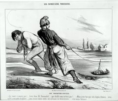
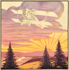
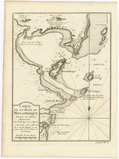
Une Navigation Difficile
By Honoré Daumier
Located in New York, NY
Honore Daumier (1808-1879), Une Navigation Difficile, lithograph, 1843, plate 6 from the series Les
Category
1840s Realist Antique Navigation
Materials
Lithograph
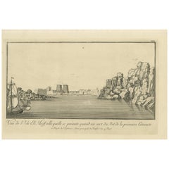
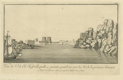
Une Navigation Difficile
By Honoré Daumier
Located in New York, NY
Honore Daumier (1808-1879), Une Navigation Difficile, lithograph, 1843, plate 6 from the series Les
Lithograph
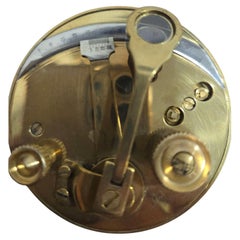
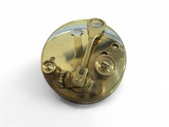
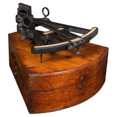
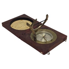
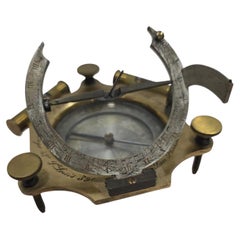
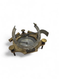
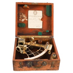
Portable Bronze Sextant for Nautical Navigation
Located in Madrid, ES
Elegant portable bronze sextant used for nautical navigation, finely crafted with precise detailing
Bronze
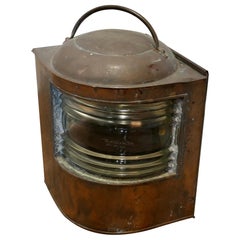
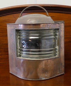
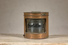
Well Weathered Ships Copper Navigation Light.
Located in Godshill, Isle of Wight
Well Weathered Ships Copper Navigation Light. The lamp is flat sided with original bowed and
Copper
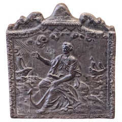
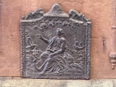
19th Century French Fireback / Backsplash 'Allegory of Navigation'
Located in Amerongen, Amerongen
19th Century French Napoleon III Period fireback with an allegory of Navigation. The fireback is
Iron
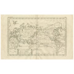
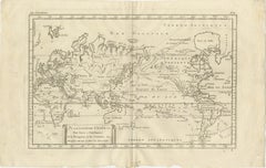
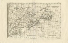
General World Planisphere for Navigation & Trade – Bonne c.1780
Located in Langweer, NL
General World Planisphere for Navigation & Trade – Bonne c.1780 DESCRIPTION This large planisphere
Paper
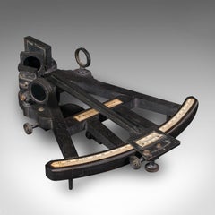
Antique Cased Octant, Scottish, Ebony, Navigation Instrument, Sextant, Victorian
Located in Hele, Devon, GB
This is an antique cased octant. A Scottish, ebony navigational instrument, dating to the Victorian
Ebony, Walnut
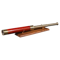
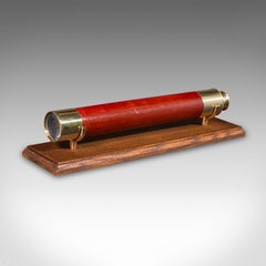
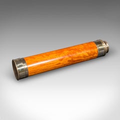
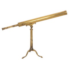
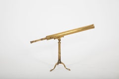
Antique 2 Draw Telescope, English, Brass, Navigational Instrument, Victorian
Located in Hele, Devon, GB
This is an antique 2-draw telescope, an English terrestrial or maritime navigational instrument
Brass
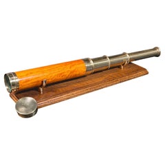
Antique Three-Draw Telescope, English, Walnut, Brass, Navigation, Georgian, 1790
Located in Hele, Devon, GB
This is an antique three-draw telescope. An English,walnut and brass navigational or astronomical
Brass
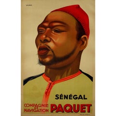
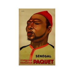
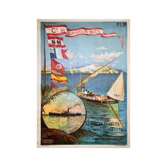
Original poster "Sénégal Compagnie de Navigation Paquet" by Viano - Africa
By Viano
Located in PARIS, FR
The original poster "Sénégal Compagnie de Navigation Paquet" by Viano, created to promote the
Linen, Paper, Lithograph
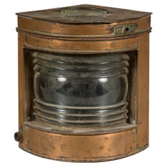
Nautical Tung Woo Starboard Ship Navigation Copper Lantern with Label
Located in Yonkers, NY
A nautical Tung Woo starboard ship navigation copper lantern from the early 20th century with label
Copper
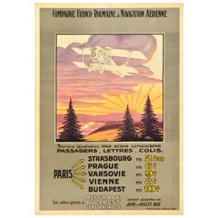
Original Antique Travel Poster Compagnie Franco Roumaine De Navigation Aerienne
Located in London, GB
Original antique travel advertising poster for the Compagnie Franco Roumaine de Navigation Aerienne
Paper

$134Sale Price|20% Off
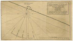
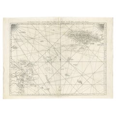
Navigational Chart of Mexico's Coast, with Acapulco and Port Marquis, 1748
Located in Langweer, NL
Prize.' - A navigational chart of the coast of Mexico, with the harbours Acapulco and Port Marquis
Paper
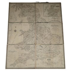
1830 DATED EXTRA LARGE 194CM X 159CM INLAND NAViGATION MAP CANALS AND RAILROADS
Located in West Sussex, Pulborough
Navigation map of Railroads and Canals by Nichols, Priestley & Walker dated January 1st 1830 This piece
Maple
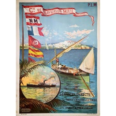
Original poster by Hugo d'Alésia for the Compagnie de Navigation mixte Touache
Located in PARIS, FR
Nice poster by Hugo d'Alésia for the Compagnie de Navigation mixte, the Touche company. The
Linen, Paper, Lithograph
$1,007Sale Price|30% Off
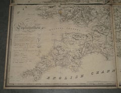
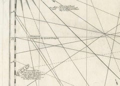
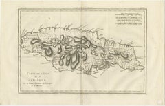
Navigational Chart of Jamaica, Cape Gracias a Dios, and the Mosquito Coast, 1775
Located in Langweer, NL
. Conclusion: This map is a detailed navigational chart from the 18th century, providing valuable information
Paper
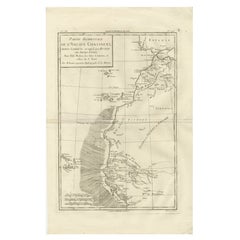
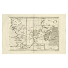
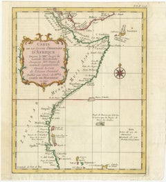
Antique Map West Africa Morocco Canary Islands Lisbon Sierra Leone Bonne, c1780
Located in Langweer, NL
when European navigation, trade, and exploration along the African coast were of great strategic
Paper

Eyes on the Horizon: A 19th-Century Captain’s Spyglass by Dollond
Located in New York, NY
respected makers of scientific and navigational instruments in the 18th and 19th centuries. Constructed with
Brass
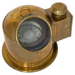
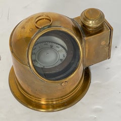
English Ship's Binnacle Compass of Brass with Side Burner Light
Located in Austin, TX
A fine English ship's binnacle compass of brass - a navigational instrument used for maritime
Metal, Brass
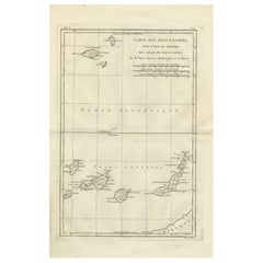
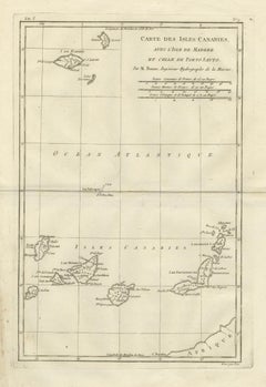
Canary Islands & Madeira Map – Atlantic Archipelagos c.1780
Located in Langweer, NL
Canary Islands, Madeira, and Porto Santo, vital Atlantic staging points for European navigation. Engraved
Paper
19th-Century French Maritime Telescope by Biette à Lyon
Located in New York, NY
. Firms such as Biette were known for producing precision scientific and navigational instruments
Brass
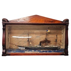
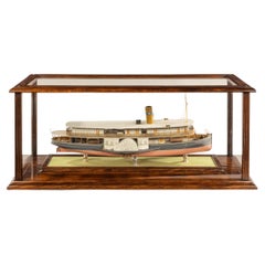
A Fantastic 19th Century Cased Model of the Royal Steam Ship 'Himalaya'
Located in Dublin, IE
Navigation Company (P&O) and laid down at the yard of C. J. Mare & Co., Leamouth, London in November
Glass, Mahogany
Antique East Indies Map by Rigobert Bonne, Copper Engraving, 1780
Located in Langweer, NL
, straits, and navigational routes. Rigobert Bonne’s engraving balances scientific accuracy with aesthetic
Paper
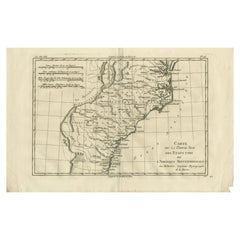
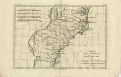
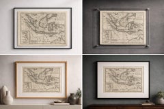
Antique Map Southern United States — Carolina & Georgia, Bonne c.1780
Located in Langweer, NL
, South Carolina, and Georgia. Coastal features, navigational inlets, and maritime approaches are
Paper
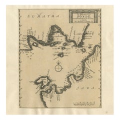
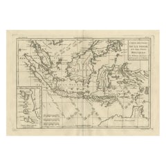
Sunda Strait Sea Chart, Sumatra and Java, Dutch Engraving c.1700
Located in Langweer, NL
maritime knowledge of one of Southeast Asia’s most important and hazardous navigational corridors. The
Paper
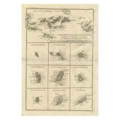
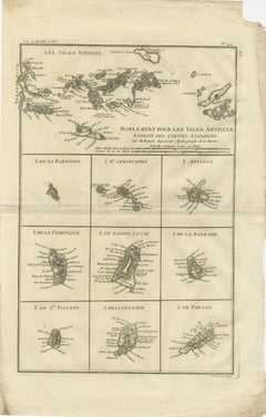
Antique Caribbean Map — Virgin Islands and Antilles Atlas Sheet, Bonne c.1780
Located in Langweer, NL
individual Caribbean islands with clarity and scale appropriate for navigational reference. These include
Paper
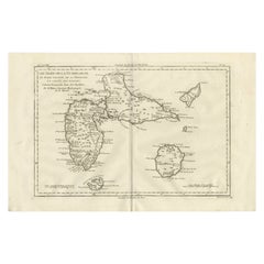
Antique Map Guadeloupe & Marie Galante, Rigobert Bonne Caribbean Chart c1780
Located in Langweer, NL
engraving and navigational usefulness characteristic of Bonne’s mature work. Numerous place names
Paper
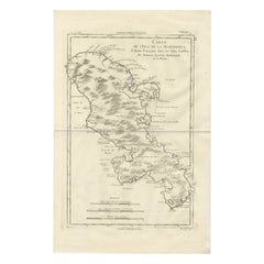
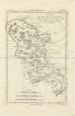
Antique Map Martinique Caribbean Island Chart, Rigobert Bonne French Map, c.1780
Located in Langweer, NL
Marin, La Trinité, and Cul-de-Sac Royal. Coastal batteries, ports, and navigational features highlight
Paper
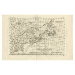
Antique Map of Canada, Newfoundland & Acadia — Gulf of St Lawrence, Bonne c.1780
Located in Langweer, NL
coastal settlements, bays, and navigational hazards. The detailed depiction of river systems and inland
Paper
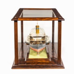
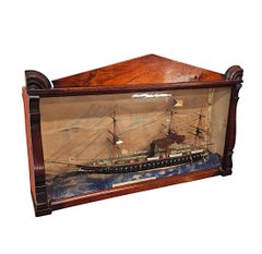
Builder’s Model of the Brazilian Passenger Paddle Steamer Caxias
Located in Lymington, Hampshire
and gilt wire railing with lifebuoys, the roof with stayed funnel with logo, whistle, navigation lamps
Laminate, Wood, Mahogany
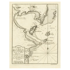
Mozambique Bay – French Naval Sea Chart by Bellin, c.1765
Located in Langweer, NL
alternative. The map focuses on navigational precision. Soundings are carefully plotted throughout the bay
Paper
Island of Philae from the First Cataract – Norden Egypt Engraving 1755
Located in Langweer, NL
valued for its early and relatively unromanticized portrayal of Philae. The plate combines navigational
Paper
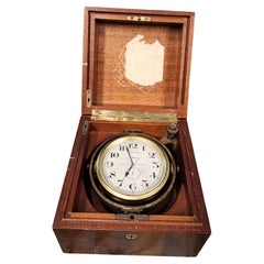
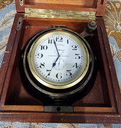
Longines Marine Chronometer Clock in Mahogany Gimbal Box 1920
Located in Potters Bar, GB
timekeeping and navigation Dial & Features The white enamel dial is clean and crisp, marked: LONGINES at 12
Mahogany
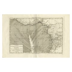
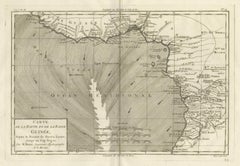
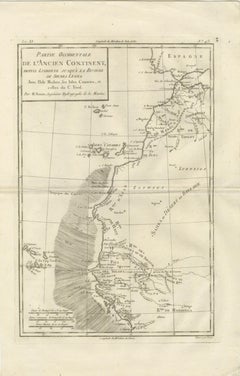
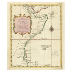
Upper & Lower Guinea Coast Map – West Africa by Bonne c.1780
Located in Langweer, NL
settlements essential to navigation and trade. Inland detail diminishes rapidly, illustrating contemporary
Paper
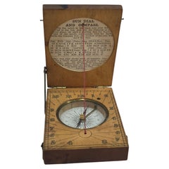
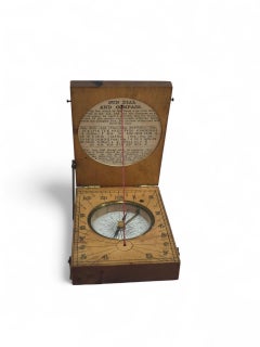
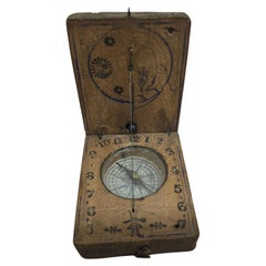
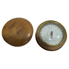
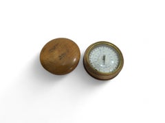
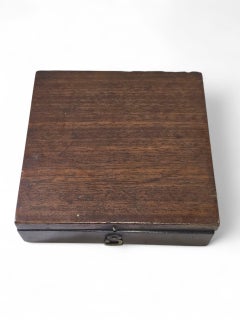
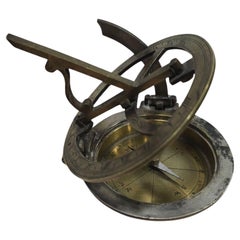
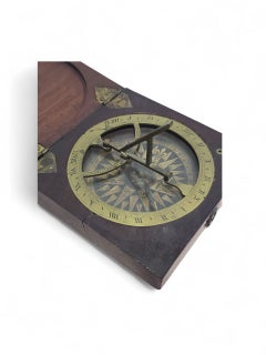
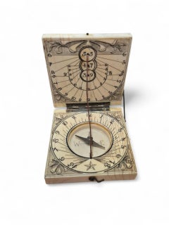
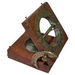
19th Century Portable Wooden Sundial
Located in Madrid, ES
scientific instrument, ideal for enthusiasts of antique horology, navigation, and curiosities.
Fruitwood
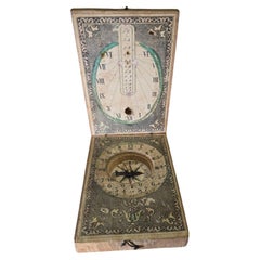
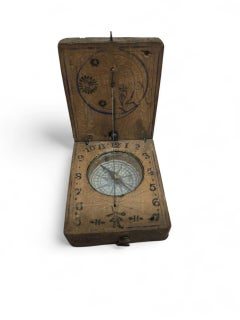
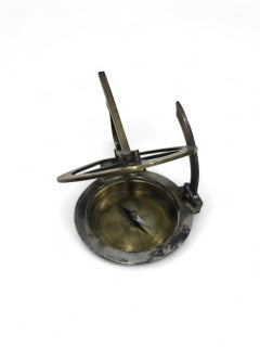
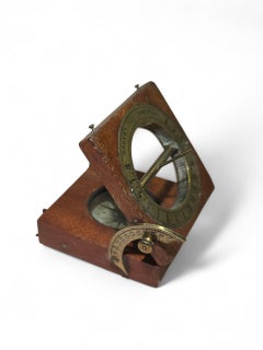
19th Century Portable Wooden Sundial
Located in Madrid, ES
scientific instrument, ideal for enthusiasts of antique horology, navigation, and curiosities.
Fruitwood
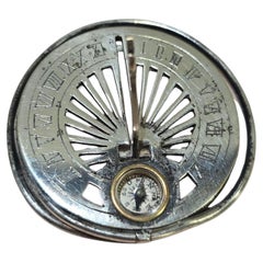
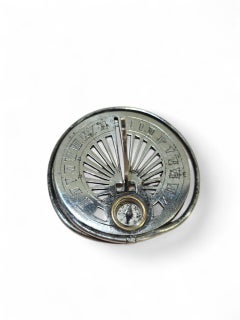
19th Century Silvered Pocket Sundial
Located in Madrid, ES
example of portable horology, ideal for collectors of antique scientific or navigational tools
Brass
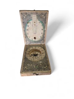
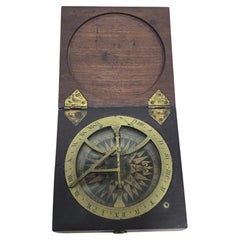
19th Century Portable Wooden Sundial
Located in Madrid, ES
collectible 19th-century scientific instrument, ideal for enthusiasts of antique horology, navigation, and
Fruitwood
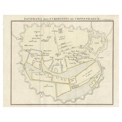
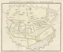
Historic Panorama of Copenhagen City Plan from Early European Travel Guide, 1819
Located in Langweer, NL
northern European trade and navigation. A particularly appealing feature is the engraved vignette in the
Paper


Denmark Antique Map with View of Copenhagen, Hand Colored Steel Engraving c.1850
Located in Langweer, NL
northern European trade and navigation. A particularly appealing feature is the engraved vignette in the
Paper
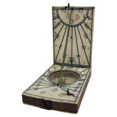
19th Century Portable Sundial in Turned Wooden Case
Located in Madrid, ES
horology, navigation, and decorative scientific instruments.
Fruitwood
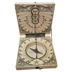
19th Century Portable Sundial in Wooden Case
Located in Madrid, ES
, navigation, and scientific curiosities.
Fruitwood
19th Century Silvered and Engraved Bronze Portable Sundial
Located in Madrid, ES
connoisseurs of antique horology, navigation, and scientific instruments.
Brass
19th Century Portable Sundial in Wooden Case
Located in Madrid, ES
of antique horology, navigation, and scientific curiosities.
Fruitwood
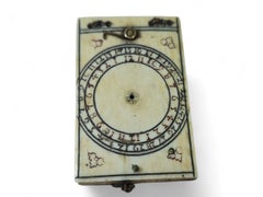
17th Century German Portable Ivory Sundial — Possibly Nuremberg
Located in Madrid, ES
for collectors of antique horology and navigation instruments.
Bone
18th Century German Portable Ivory Sundial — Possibly Nuremberg
Located in Madrid, ES
horology and navigation tools
Bone

Mozambique Channel & Madagascar – Antique African Sea Chart, Bonne c1780
Located in Langweer, NL
prevailing currents are carefully delineated, emphasizing navigation rather than inland detail. Madagascar is
Paper
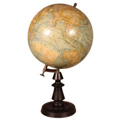
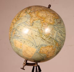
Terrestrial Globe By J. Forest Paris From The Early 20th Century
Located in Brussels, Brussels
, with no samage. It depicts ocean currents, navigation lines, sea depths, and mountain heights. The
Paper
East African Coast – French Map by Bellin, Zanzibar to Arabia, 1740
Located in Langweer, NL
Comoros, including Anjouan. Bellin’s engraving emphasizes coastal continuity and navigational clarity
Paper
19th Century Portable Sundial Signed “Dollond London” — Wood and Brass
Located in Madrid, ES
addition for collectors of antique horology and navigation instruments.
Fruitwood
19th Century American Portable Engraved Bronze Sundial
Located in Madrid, ES
horology, navigation, and scientific instruments.
Brass
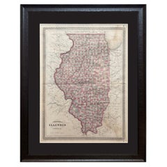
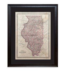
1870 "Johnson's Illinois" Map Published by A. J. Johnson
Located in Colorado Springs, CO
, making the atlas a valuable resource not just for navigation and geography, but also for understanding
Paper
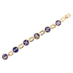
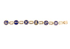
Cartier Lapis Lazuli Transportation Motif Gold Bracelet
By Cartier
Located in New York, NY
navigation, and railway tracks, reflecting Cartier’s unique approach to thematic jewelry design. This
Lapis Lazuli, Gold
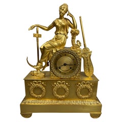
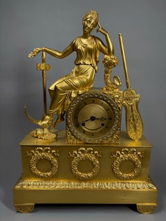
A French Gilt bronze Charles X mantel clock, circa 1825
Located in Sleepy Hollow, NY
and Paris, c. 1825. The sculptural group represents an allegory of navigation or Hope and features a
Bronze, Ormolu
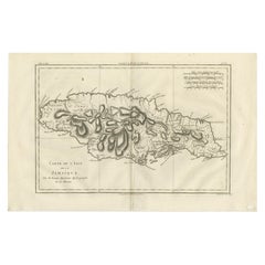
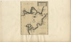
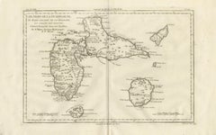
Jamaica – Original Antique Island Map by Rigobert Bonne, c.1780
Located in Langweer, NL
, reflecting the map’s hydrographic function and relevance to navigation. Visually calm yet authoritative, the
Paper
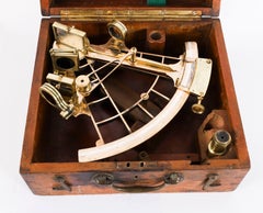
Antique Heath & Co Lacquered Brass Vernier Sextant 19th Century
By Heath & Co.
Located in London, GB
- Casket A Heath & Co. Sextants Ltd. was a London based manufacturer of high quality navigational sextants
Brass
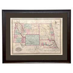
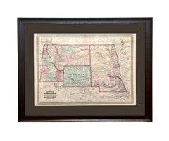
1870 "Johnson's Nebraska, Dakota, Idaho, Montana and Wyoming" Antique Map
Located in Colorado Springs, CO
scientific inquiry, making the atlas a valuable resource not just for navigation and geography, but also for
Paper
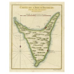
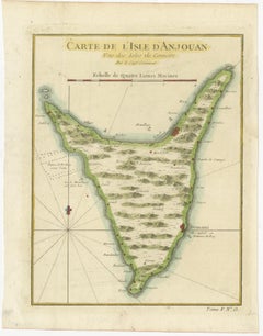
Anjouan Island, Comoros – French Naval Sea Chart by Bellin, c.1765
Located in Langweer, NL
for practical navigation rather than purely decorative purposes. The coastline is shown in careful
Paper