19th Century Maps
to
1,671
2,184
70
2,257
72
9
5
4
2
2
1
1
2,929
2,257
475
3
290
34
10
126
10
37
9
2
5
4
3
3
2,219
66
28
12
10
329
172
104
101
97
2,257
2,257
2,257
104
23
9
8
7
Period: 19th Century
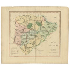
Antique Hand-Colored County Map of Rutland, England, 1804
Located in Langweer, NL
Antique county map of Rutland first published c.1800. Villages, towns, and cities illustrated include Oakham, Uppingham, and Normanton.
Charles ...
Category
Antique 19th Century Maps
Materials
Paper
$307 Sale Price
20% Off
1882 Map of Sweden and Norway Highlighting Geographical and Political Features
Located in Langweer, NL
This 1882 map of Sweden and Norway, published by Blackie and Son as part of the 'Comprehensive Atlas and Geography of the World,' provides a detailed depiction of the Scandinavian Pe...
Category
Antique 19th Century Maps
Materials
Paper
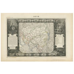
Antique Map of Asia by V. Levasseur, 1854
Located in Langweer, NL
Antique map titled 'Asie'. Map of the main Asian continent. The decorated border shows various images, as well as two blocks of statistical text on the continent, including populatio...
Category
French Antique 19th Century Maps
Materials
Paper
$243 Sale Price
25% Off
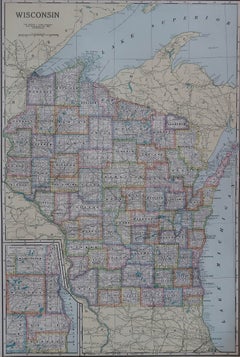
Large Original Antique Map of Wisconsin, USA, circa 1900
Located in St Annes, Lancashire
Fabulous map of Wisconsin
Original color
Engraved and printed by the George F. Cram Company, Indianapolis.
Published, circa 1900
Unframed
Category
American Antique 19th Century Maps
Materials
Paper
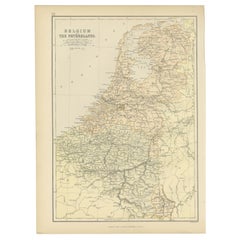
1882 Map of Belgium and The Netherlands Highlighting Geographical Details
Located in Langweer, NL
This 1882 map of Belgium and The Netherlands, published by Blackie and Son as part of the 'Comprehensive Atlas and Geography of the World,' offers a detailed representation of the tw...
Category
Antique 19th Century Maps
Materials
Paper
$179 Sale Price
20% Off
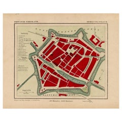
Antique Map of Dokkum a City in the North of Friesland, the Netherlands, 1868
Located in Langweer, NL
Antique map titled 'Provincie Friesland - Gemeente Dokkum'. Map of the township of Dokkum, Friesland. This map originates from 'Gemeente-Atlas van Nederland' by J. Kuyper.
The best-known event in Dokkum's history is the martyrdom of the Anglo-Saxon missionary Saint Boniface (Dutch: Bonifatius) in 754. Oliver of Cologne preached the Fifth Crusade in Dokkum in 1214 and Dokkum sent a contingent; the crescent in the coat of arms of Dokkum refers to this event. Dokkum acquired city rights in 1298. In 1572 Dokkum was sacked by the Spaniards after it had joined the Dutch Revolt...
Category
Antique 19th Century Maps
Materials
Paper
$170 Sale Price
20% Off
Vue du Chateau d'Ouandipore, Prévost, 1802
Located in Langweer, NL
Vue du Chateau d'Ouandipore'. (View of the Castle of Wandipore in Tibet). This original antique print is taken from 'Histoire générale des voyages (?).', pu...
Category
Antique 19th Century Maps
Materials
Paper
$51 Sale Price
20% Off
Antique Map of Basses Pyrénées ‘France’ by V. Levasseur, 1854
Located in Langweer, NL
Antique map titled 'Dépt. des Bses. Pyrénées'. Map of the French department of Basses Pyrenees, France. This department includes the Jurancon wine region, famous for its production d...
Category
Antique 19th Century Maps
Materials
Paper
$170 Sale Price
20% Off
1844 French Nautical Portolano of Port De Chichimé Natolie by Antoine Roux
By Antoine Roux
Located in Milan, IT
Antique portolano, nautical map of Port De Chichimé Natolie engraved on a copper plate by Antoine Roux, Marseille France 1844, from his work Recueil des principaux plans des ports et...
Category
French Antique 19th Century Maps
Materials
Paper
1882 Map of the North Atlantic Ocean Showing Cable Tracks and Trade Winds
Located in Langweer, NL
This 1882 map of the North Atlantic Ocean, published by Blackie and Son as part of the 'Comprehensive Atlas and Geography of the World,' provides an intricate depiction of one of the...
Category
Antique 19th Century Maps
Materials
Paper
1882 Map of Brazil: Historic Borders, River Systems, and Coastal Regions
Located in Langweer, NL
Title: 1882 Map of Brazil: Historic Borders, River Systems, and Coastal Regions
Description:
This 1882 map presents a detailed cartographic view of Brazil, the largest country in S...
Category
Antique 19th Century Maps
Materials
Paper
Rare Print of the 'Corps Des Guides' of the Belgium Army Regiment, 1833
Located in Langweer, NL
One nicely hand coloured print of an original serie of 23 plates, showing officers and soldiers resting near a village. published in 1833. Rare.
From a serie of beautiful lithographed plates with Belgian military...
Category
Antique 19th Century Maps
Materials
Paper
$302 Sale Price
20% Off
Antique Print of a Garden Building from Garden Architecture by Van Laar, 1802
Located in Langweer, NL
Untitled print of garden architecture. It shows garden buildings. This print originates from 'Magazijn van tuin-sieraden'. The book is compiled by Gijs...
Category
Antique 19th Century Maps
Materials
Paper
Antique Map of Europe by W. G. Blackie, 1859
Located in Langweer, NL
Antique map titled 'Europe'. Original antique map of Europe. This map originates from ‘The Imperial Atlas of Modern Geography’. Published by W. G. Blackie, 1859.
Category
Antique 19th Century Maps
Materials
Paper
$236 Sale Price
20% Off
Antique Map of The Province Noord-Holland in The Netherlands, 1864
Located in Langweer, NL
Antique map titled 'De Provincie Noord-Holland'. Map of the province of Noord-Holland, the Netherlands. This map originates from 'F. C. Brugsma's Atlas van het Koninkrijk der Nederla...
Category
Antique 19th Century Maps
Materials
Paper
$113 Sale Price
20% Off
Map of the East Coast of Hanshu or Honshu & a View of the Japanese Coast, 1803
Located in Langweer, NL
Antique map titled 'Gedeelte van Japan of Nipon'.
Map of the east coast of Hanshu, with a view of the Japanese coast titled 'Gezigt van de Kust van Japan, wanneer wij haar voor h...
Category
Antique 19th Century Maps
Materials
Paper
$491 Sale Price
20% Off
Original Antique Print of Decorative Art in the Middle Ages, 1869
Located in Langweer, NL
Old print of decorative art in the Middle Ages. This print originates from 'L'Ornement polychrome'. A beautiful work containing about...
Category
Antique 19th Century Maps
Materials
Paper
$141 Sale Price
20% Off
Antique Geographical, Historical and Statistical Map of Massachusetts, 1822
Located in Langweer, NL
This attractive map of Massachusetts presents a finely detailed overview of the state in the first quarter of the 19th century.
Transportation ...
Category
Antique 19th Century Maps
Materials
Paper
$359 Sale Price
20% Off
Large Original Antique Map of Europe by Sidney Hall, 1847
Located in St Annes, Lancashire
Great map of Europe
Drawn and engraved by Sidney Hall
Steel engraving
Original colour outline
Published by A & C Black. 1847
Unframed
Free shipping.
Category
Scottish Antique 19th Century Maps
Materials
Paper
Antique Map of Australia and Polynesia, inset of Tasmania c.1860
Located in Langweer, NL
German antique map titled 'Australien und Polynesien'. Old map of Australia (New Holland) and Polynesia. With an inset map of Southern Australia including Tasmania (Van Diemen's Land...
Category
Antique 19th Century Maps
Materials
Paper
$113 Sale Price
20% Off
Antique Print of the Residence House in Serang, Java, Indonesia, 1844
Located in Langweer, NL
Antique print titled 'Het Residentie-Huis te Serang - Maison du Resident à Serang'. Old print with a view of the residence house in Serang. Originates from 'Gezigten uit Neerlands In...
Category
Antique 19th Century Maps
Materials
Paper
Old Map of the French Department of Eure-et-loir, France
Located in Langweer, NL
Antique map titled 'Dépt. d'Eure et Loir'. Map of the French department of Eure-et-Loir, France. This area is home to the famous Chartres Cathedral....
Category
Antique 19th Century Maps
Materials
Paper
$321 Sale Price
20% Off
Copenhagen (Kiöbenhaven) Map with City View – Antique German Atlas Print, 1844
Located in Langweer, NL
Copenhagen (Kiöbenhaven) Map with City View – Antique German Atlas Print, 1844
This finely detailed antique map titled 'Copenhagen (Kiöbenhaven)' presents a historical view of Denma...
Category
German Antique 19th Century Maps
Materials
Paper
Neatly Framed Decorative Hand-Colored View of Zierikzee, the Netherlands, 1858
Located in Langweer, NL
Antique print titled 'Zierikzee'.
View of the city of Zierikzee, the Netherlands. This print originates from 'Het koningrijk der Nederlanden voorgesteld in eene reeks van 136 naa...
Category
Antique 19th Century Maps
Materials
Paper
$463 Sale Price
20% Off
Floor Model Terrestrial Globe Made in Germany by Dietrich Reimer Kiepert as is
By Dietrich Reimers 1, Heinrich Kiepert
Located in New York, NY
Impressive floor model globe Made in Germany Heinrich Kiepert, Dietrich Reimer c late 19th C / Early 20 C. The large ( 22" Dia. ) globe fits into the reeded oak column base, on a s...
Category
German Victorian Antique 19th Century Maps
Materials
Metal
Antique Map of Bavaria in Southern Germany and Austria, 1806
Located in Langweer, NL
Antique map titled 'Cercles de Baviere et d'Autriche.' This map shows Bavaria in southern Germany and Austria. By Robert de Vaugondy, revised and published by Delamarche. Source unkn...
Category
Antique 19th Century Maps
Materials
Paper
$330 Sale Price
20% Off
Antique Map of the World, Mercator Projection, by Wyld, '1845'
Located in Langweer, NL
Antique map titled 'The World'. Original antique world map, on Mercator's projection. This map originates from 'An Atlas of the World, Compr...
Category
Antique 19th Century Maps
Materials
Paper
$330 Sale Price
20% Off
Antique Folding Map of England and Wales
Located in Langweer, NL
Antique map titled 'England and Wales'. Original folding map of England and Wales. Publishes by A. & C. Black, circa 1890.
Category
Antique 19th Century Maps
Materials
Paper
$396 Sale Price
20% Off
Pl. 90 Antique Print of Decorative Art in the 18th Century by Racinet, 1869
Located in Langweer, NL
Old print of decorative art in the 18th century. This print originates from 'L'Ornement polychrome'. A beautiful work containing about 2000 patterns of all the styles of Art old and ...
Category
Antique 19th Century Maps
Materials
Paper
Antique Map of the Arctic Regions by Lowry '1852'
Located in Langweer, NL
Antique map titled 'Arctic Regions'. Original map of the Arctic Regions. This map originates from 'Lowry's Table Atlas constructed and engraved from the most recent Authorities' by J...
Category
Antique 19th Century Maps
Materials
Paper
$94 Sale Price
20% Off
Antique Map of British India with Insets of Kabul and Nepal
Located in Langweer, NL
Antique map titled 'British India, northern part'. Large format map of the northern area of the Indian subcontinent. The map is engraved in the minimalist English style pioneered in ...
Category
Antique 19th Century Maps
Materials
Paper
$548 Sale Price
20% Off
Colton's Map of Illinois, with an Inset of Chicago
Located in Langweer, NL
Antique map titled 'Colton's Illinois'. Antique map of Illinois, a state in the Midwestern United States. With an inset map of of Cook County &...
Category
Antique 19th Century Maps
Materials
Paper
$226 Sale Price
20% Off
Antique Map of British North America by W. G. Blackie, 1859
Located in Langweer, NL
Antique map titled 'British North America'. Original antique map of British North America. This map originates from ‘The Imperial Atlas of Mode...
Category
Antique 19th Century Maps
Materials
Paper
$236 Sale Price
20% Off
Large Original Antique Map of Alabama, USA, C.1900
Located in St Annes, Lancashire
Fabulous map of Alabama
Original color
Engraved and printed by the George F. Cram Company, Indianapolis.
Published, C.1900
Unframed
Repair to a minor edge tear top left corner
...
Category
American Antique 19th Century Maps
Materials
Paper
Rare Antique Print of a Park in Utrecht, The Netherlands, c.1860
Located in Langweer, NL
Antique print Utrecht titled 'Gezigt in het Plantsoen op de Malie-Barrière te zien'. Old tinted lithograph depicting a park of Utrecht. This print orginates from ' Een Cahier Gezigte...
Category
Antique 19th Century Maps
Materials
Paper
$217 Sale Price
20% Off
Ancient Realms of Northeast Africa: Arabia, Ethiopia, and Egypt, Published 1880
Located in Langweer, NL
This map, titled "ARABIA, AETHIOPIA, AEGYPTUS," illustrates the regions of ancient Arabia, Ethiopia, and Egypt.
Features that make this map interesting include:
1. **Geographical ...
Category
Antique 19th Century Maps
Materials
Paper
$444 Sale Price
20% Off
Original Antique Map Covering the Russian Empire in Asia, 1880
Located in Langweer, NL
Antique map titled 'Sibérie ou Russie d'Asie'.
Migeon's map covers the Russian empire in Asia from european Russia and the Ural Mountains to the Bering Strait and from the Arctic...
Category
Antique 19th Century Maps
Materials
Paper
$160 Sale Price
20% Off
Antique Map of Southern Italy by J. Tallis, circa 1851
Located in Langweer, NL
Decorative and detailed mid-19th century map of Southern Italy which was drawn and engraved by John Rapkin (vignettes by A. H. Wray and J. Rogers...
Category
Antique 19th Century Maps
Materials
Paper
$259 Sale Price
20% Off
Antique Map of the Eastern Hemisphere by Wyld, 1842
Located in Langweer, NL
Antique map titled 'Eastern Hemisphere'. Large map depicting the continents Europe, Asia, Afrika and Australia.
Artists and Engravers: James Wyld (1812–1887) was a British geograph...
Category
Antique 19th Century Maps
Materials
Paper
$1,039 Sale Price
20% Off
Antique Map of Iowa and Nebraska by Johnson, '1872'
Located in Langweer, NL
Antique map titled 'Johnson's Iowa and Nebraska'. Original map of Iowa and Nebraska. This map originates from 'Johnson's New Illustrated Family Atlas of th...
Category
Antique 19th Century Maps
Materials
Paper
$236 Sale Price
20% Off
Antique Map of Prussia and Mecklenburg by W. G. Blackie, 1859
Located in Langweer, NL
Antique map titled 'Prussia and Mecklenburg'. Original antique map of Prussia and Mecklenburg with inset map of East Prussia. This map originates from ‘Th...
Category
Antique 19th Century Maps
Materials
Paper
$236 Sale Price
20% Off
Antique Map of the Chinese Empire and Japan by Lapie, 1842
Located in Langweer, NL
Antique map titled 'Carte de L'Empire Chinois et du Japon'. Map of the Chinese Empire (China) and Japan. This map originates from 'Atlas universel de géographie ancienne et moderne (...
Category
Antique 19th Century Maps
Materials
Paper
$519 Sale Price
20% Off
Original Antique Map in Frame of Greece by Smith '1818'
Located in Langweer, NL
Nicely framed map titled 'Greece'. Original antique map of Greece published by C. Smith, 1818. Frame included.
Category
Antique 19th Century Maps
Materials
Paper
$330 Sale Price
20% Off
Antique Map of New South Wales with an Inset of Sydney, Australia, 1833
Located in Langweer, NL
Antique map of Australia titled 'New South Wales'. Old map of New South Wales, Australia. With an inset map of Sydney. Arists and Engravers: Engraved by J. & C. Walker. Published by ...
Category
Antique 19th Century Maps
Materials
Paper
$519 Sale Price
20% Off
Antique Map of Africa by A & C, Black, 1870
Located in Langweer, NL
Antique map titled 'Africa'. Original antique map of Africa. This map originates from ‘Black's General Atlas of The World’. Published by A & C. Black, 1870.
Category
Antique 19th Century Maps
Materials
Paper
$259 Sale Price
20% Off
Antique Map of the Departments of France by Migeon, 1880
By J. Migeon
Located in Langweer, NL
Antique map titled 'France par Départements'. Old map of France with a decorative vignette of Strasbourg and an inset map of Corsica. This map originate...
Category
Antique 19th Century Maps
Materials
Paper
$113 Sale Price
20% Off
Antique Map of the City of Assen in The Netherlands, 1865
Located in Langweer, NL
Drenthe - Gemeente Assen. (no 2, Stad). These scarse detailed maps of Dutch Towns originate from the 'Gemeente-atlas' of Jacob Kuyper. This atlas of all towns in the Netherlands was ...
Category
Antique 19th Century Maps
Materials
Paper
$274 Sale Price
20% Off
Steel Engraving of Haddon Hall, River Wye, Bakewell, Derbyshire, England, 1875
Located in Langweer, NL
Antique print titled 'The Terrace, Haddon Hall'.
Steel engraving of the terrace of Haddon Hall. Haddon Hall is an English country house on the River Wye ...
Category
Antique 19th Century Maps
Materials
Paper
$170 Sale Price
20% Off
Antique Map of French Polynesia by Cook Showing His Route, 1803
Located in Langweer, NL
Antique map Tahiti titled 'Kaart van de Eilanden in den omtrek van Otahiti (..)'. Antique map of French Polynesia with the tracks around the island of Tahiti by Captain Byron, Wallis...
Category
Antique 19th Century Maps
Materials
Paper
$448 Sale Price
20% Off
Antique Map of Victoria, or Port Phillip in Australia, ca. 1850
Located in Langweer, NL
This antique map, measuring approximately 12.7 x 10.0 inches, showcases Victoria, specifically centered around Melbourne, Australia. Crafted by John Tallis around 1850, this map is p...
Category
European Antique 19th Century Maps
Materials
Paper
$680 Sale Price
20% Off
Early San Francisco View by Henry Firks Printed by W.H. Jones in 1849
Located in San Francisco, CA
A tinted lithographic view of San Francisco, made during the gold rush, showing a panoramic view of the bay's waterfront from the south along Montgomery Street to Telegraph Hill. The...
Category
American Victorian Antique 19th Century Maps
Materials
Paper
Old Costume Print Showing People at the Fair in Rotterdam, The Netherlands, 1817
Located in Langweer, NL
Antique costume print titled 'Group at the Fair at Rotterdam'.
Old costume print depicting a group of people from Rotterdam. This print originates from 'The Costume of the Nether...
Category
Antique 19th Century Maps
Materials
Paper
$226 Sale Price
20% Off
Antique Map Depicting Burma, Siam, Annam (Vietnam) and Japan, 1882
Located in Langweer, NL
The image shows two maps side by side from the 1882 atlas by Blackie & Son. On the left, the map is titled "BURMAH SIAM AND ANAM," while the one on the right is labeled "JAPAN."
**B...
Category
Antique 19th Century Maps
Materials
Paper
$236 Sale Price
20% Off
Antique Hemisphere Map of the World 'Two on One Sheet' by Levasseur, '1875'
Located in Langweer, NL
Antique map titled 'Mappemonde projetée sur l'Horizon de Paris et de son Antipode - Mappemonde sur la projection polaire'. Large map with two hemisphere world maps...
Category
Antique 19th Century Maps
Materials
Paper
$324 Sale Price
44% Off
Antique Print of a Cap and Lace Collar by Gibb, 1890
Located in Langweer, NL
Antique print titled 'Skull-Cap of King Charles I - Lace Collar'. Chromolithographic plate originating from 'The Royal House of Stuart. Illustrated By a Series of Forty Plates in Col...
Category
Antique 19th Century Maps
Materials
Paper
$80 Sale Price
20% Off
Hand Colored Antique Map of the Department of L'ain, France
Located in Langweer, NL
Antique map titled 'Dépt. de l'Ain'. Map of the French department of l'Ain, France. This area of France is known for its Bugey wines, which are generally aromatic and white. It is also known for its fine blue cheese...
Category
Antique 19th Century Maps
Materials
Paper
$321 Sale Price
20% Off
Antique Decorative Coloured Map of South Africa and Madagascar, 1882
Located in Langweer, NL
The map of South Africa is from the Blackie & Son Atlas, published in 1882. This historical map is quite interesting for several reasons:
1. **Historical Period**: This map was crea...
Category
Antique 19th Century Maps
Materials
Paper
Antique Map of the Department De Tarn, 'France' by v. Levasseur, c. 1852
Located in Langweer, NL
Antique map titled 'Dépt Du Tarn'. Map of the French department of Du tarn, France.
This area produces a variety of traditional wines, including Cahors, Mauzac, Loin de l’Oeil an...
Category
French Antique 19th Century Maps
Materials
Paper
$212 Sale Price
20% Off
Antique Map of Tunis and Tripoli in Northern Africa, circa 1880
By J. Migeon
Located in Langweer, NL
Antique map titled 'Tunis et Tripoli & Empire de Maroc'. Old map of Tunis and Tripoli and the Empire of Morocco. This map originates from 'Géographie Universelle Atlas-Migeon' by J. ...
Category
Antique 19th Century Maps
Materials
Paper
$151 Sale Price
20% Off
Antique Map of Chile, La Plata and Part of Bolivia by A & C. Black, 1870
Located in Langweer, NL
Antique map titled 'Chili, La Plata & Bolivia'. Original antique map of Chile, La Plata and Part of Bolivia. This map originates from ‘Black's General Atlas o...
Category
Antique 19th Century Maps
Materials
Paper
$144 Sale Price
30% Off
