Engraved Maps
to
329
789
62
851
3
589
260
2
1
849
7
3
1
1
407
143
112
81
41
851
851
851
2
2
2
2
1
Technique: Engraved
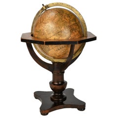
German Globe by C. Abel-Klinger, Nuremberg, circa 1860
Located in Milano, IT
Terrestrial globe
Artistic company C. Abel - Klinger
Nuremberg, circa 1860
H cm 31 x 22 cm (12.20 x 8.66 in); sphere 14 cm (5.51 in) in diameter
lb 2.30 (kg 1.04)
State of conservation: good. On the sphere there are slight visible signs of accidental bumping at the poles, as well as on New Guinea and England (vertical and more visible); some ink stains, especially at the South Pole and on the meridian that crosses North America.
The globe is composed of twelve whole gores of printed paper, juxtaposed and glued on a sphere made with a chalky base mixture.
The circle of the meridian, made of brass...
Category
1860s German Other Antique Engraved Maps
Materials
Wood, Paper
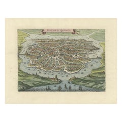
Antique Bird's-Eye View of Hangzhou (China) by Matthäus Merian, 1638
Located in Langweer, NL
This is an exquisite antique bird's-eye view map of Hangzhou, historically referred to as "Xuntien or Quinzay," from the first edition of Matthäus Merian's publication in 1638. This ...
Category
1630s Antique Engraved Maps
Materials
Paper
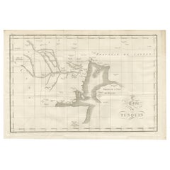
Antique Map of Tonkin and Hainan Island – 18th Century French Engraving
Located in Langweer, NL
Antique Map of Tonkin and Hainan Island – 18th Century French Engraving
This is the “5me Carte du Tunquin,” an antique engraved map depicting the northern coastal region of modern-d...
Category
Late 18th Century French Antique Engraved Maps
Materials
Paper
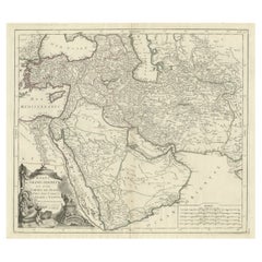
Detailed Original Antique Map of the Turkish Empire with Arabia, 1778
Located in Langweer, NL
Title: Etats Due Grand-Seigneur En Asie, Empire De Perse, Pays Des Usbecs, Arabie et Egypte . . . 1753
Detailed map of the Turkish Empire, extending to the Black Sea, Georgia, the...
Category
1770s Antique Engraved Maps
Materials
Paper
$459 Sale Price
20% Off
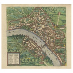
Bird’s-Eye View of Basel from Braun & Hogenberg’s Civitates Orbis Terrarum, 1575
Located in Langweer, NL
Bird’s-Eye View of Basel from Braun & Hogenberg’s "Civitates Orbis Terrarum" (Circa 1572-1617)
This highly detailed map of Basel is a bird's-eye view, originally based on Sebastian Münster’s map...
Category
16th Century Antique Engraved Maps
Materials
Paper
$1,147 Sale Price
20% Off
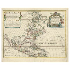
Scarce Latin Edition of Guillaume Delisle's 1700 Map of North America
Located in Langweer, NL
Scarce German Edition of Guillaume Delisle's 1700 Map of North America
This beautifully colored and highly detailed map is a rare Latin edition of Guillaume Delisle's influential 17...
Category
Early 1700s Antique Engraved Maps
Materials
Paper
$1,865 Sale Price
20% Off
Old Map of the Mughal Empire, Persia in the West to Lake Chimay etc., ca.1685
Located in Langweer, NL
Antique map titled 'L'Empire du Grand Mogol'. Old map of India and Central Asia.
The map extends from Persia in the West to Lake Chimay and the Bay of Bengal...
Category
1680s Antique Engraved Maps
Materials
Paper
$306 Sale Price
20% Off
Biblical Journeys: Apostle Paul's Voyages and the Israelites' Exodus, 1856
Located in Langweer, NL
Two maps in matting board. From the Pictorial Bible Atlas, published in 1856.
Title for Map 1: Voyages and Travels of Apostle Paul – Illustrated Antique...
Category
1850s Antique Engraved Maps
Materials
Paper
1690 Frederick de Wit Sea Chart of Hudson Bay, Baffin Bay and Greenland
Located in Langweer, NL
Title: c. 1690 Frederick de Wit Sea Chart of Hudson Bay, Baffin Bay, and Greenland - Engraved by Romeyn de Hooghe
This striking sea chart by Frederick de Wit, titled "Septemtrionali...
Category
1690s Antique Engraved Maps
Materials
Paper
Map of Cape Verde and the Mouth of the River Niger by Coronelli, 1691
Located in Langweer, NL
Map of Cape Verde and the Mouth of the River Niger by Coronelli, 1691
This finely engraved map, titled "Bocche del Fiume Negro et Isole di Capo Verde," was created in 1691 by Vincen...
Category
Late 17th Century Antique Engraved Maps
Materials
Paper
1710 Edward Wells Detailed Ancient Greece Map with Ornate Cartouche
Located in Langweer, NL
"1710 Edward Wells Map of Ancient Greece: A New Map of Antient Greece, Tirana, Morea, Ilyricum, Sicily, and Macedonia"
Description of the Map:
This map, produced around 1710 and en...
Category
1710s Antique Engraved Maps
Materials
Paper
$736 Sale Price
20% Off
Engraving of a Map of Florida, the Gulf Coast, Caribbean & Central America, 1728
Located in Langweer, NL
This exceptional antique map, titled "Nouvelle Carte Marine de Toute les Cotes de l´Amerique" and alternatively known as "Nieuwe groote en seer Curieuse Paskaart van Geheel-WestIndie...
Category
Mid-18th Century Dutch Antique Engraved Maps
Materials
Paper
South Sweden Map with Inset of Halmstad – Antique Map by Frederik de Wit, c.1680
Located in Langweer, NL
South Sweden Map with Inset of Halmstad – Antique Map by Frederik de Wit, c.1680
This richly detailed antique map titled Accurata Scaniae, Blekingae et Hallandiae Descriptio present...
Category
Late 17th Century Dutch Antique Engraved Maps
Materials
Paper
$808 Sale Price
20% Off
Antique Map of the North Pole by V.M. Coronelli, circa 1692
Located in Langweer, NL
Globe gore by Vincenzo Maria Coronelli shows the North Pole with the coasts of Canada, Greenland, Scandinavia and Siberia, and is decorated with pictorial scenes of bear, seal and wh...
Category
Late 17th Century Italian Antique Engraved Maps
Materials
Paper
$1,004 Sale Price
40% Off
Map of Choromandel & Malabar, Incl Kerala, Tamil Nadu & Part of Sri Lanka, 1726
Located in Langweer, NL
Antique map titled 'Nieuwe kaart van Choromandel ende Malabar.'
Original antique map of Southern India documenting the VOC's areas of influence. Included is Kerala, Tamil Nadu...
Category
1720s Dutch Antique Engraved Maps
Materials
Paper
$585 Sale Price
50% Off
Antique Map of the Island of Tahiti, Polynesia, 1803
Located in Langweer, NL
Antique map Tahiti titled 'Kaart van het Eiland Otahiti'.
Antique map of the Island of Tahiti, Polynesia. Originates from 'Reizen Rondom de Waereld door James Cook (..)'.
Artists...
Category
Early 1800s Dutch Antique Engraved Maps
Materials
Paper
$532 Sale Price
50% Off
Antique Map of Mecklenburg-Vorpommern in Germany by J.B. Homann, c.1720
Located in Langweer, NL
Antique Map of Mecklenburg-Vorpommern by J.B. Homann, c.1720
Old colored antique map of Mecklenburg-Vorpommern by Johann Baptist Homann. This stunning map, titled "Ducatus Meklenbur...
Category
1720s Antique Engraved Maps
Materials
Paper
$516 Sale Price
20% Off
Engraving of St. Gallen and its Monastery, from Civitates Orbis Terrarum (1575)
Located in Langweer, NL
Description of the Engraving: Braun & Hogenberg’s "S. Galli Opp. et Monasterium Heluetiorum" from Civitates Orbis Terrarum (1575)
This is an original, hand-colored copper engraving ...
Category
16th Century Antique Engraved Maps
Materials
Paper
$660 Sale Price
20% Off
Antique Map of Warwickshire in England by Speed, c.1614
Located in Langweer, NL
Antique map titled 'The Counti of Warwick the Shire Towne and Citie of Coventre described'. Map of Warwickshire, England. Includes inset town plans of Warwic...
Category
17th Century Antique Engraved Maps
Materials
Paper
$726 Sale Price
20% Off
Beautiful and Rare Original Antique Engraving of a Village in Tonga, 1817
Located in Langweer, NL
Fete donnee au General Dentrecasteaux par Toubau, Roi des Iles des Amis
Original antique engraving showing the party given to General Dentrecasteaux by Toubau, King of the Friendl...
Category
1810s Antique Engraved Maps
Materials
Paper
$612 Sale Price
20% Off
Navigational Chart of Jamaica, Cape Gracias a Dios, and the Mosquito Coast, 1775
Located in Langweer, NL
The map titled "The Island of Jamaica and Cape Gracias a Dios with the Banks (Shows Moskito Kings Party)" illustrates a significant historical period marked by shifting colonial infl...
Category
1770s Antique Engraved Maps
Materials
Paper
$1,004 Sale Price
30% Off
Spectacular 1770 Bird's-Eye View of Dunkirk Harbor by Basset, with 66 Landmarks
Located in Langweer, NL
This engraving, titled *Vue de Dunkerque du coté de la Mer*, is a spectacular bird's-eye view of Dunkirk from the sea, published by Basset around 1770.
It provides a detailed panor...
Category
1770s Antique Engraved Maps
Materials
Paper
$468 Sale Price
20% Off
1821 Thomson Map of Guadeloupe, Marie-Galante and Antigua in the West Indies
Located in Langweer, NL
This map, published in 1821 by John Thomson, showcases Guadeloupe, Marie-Galante, and Antigua from the *West India Islands* collection. Part of Thomson's *New General Atlas*, it prov...
Category
1820s Antique Engraved Maps
Materials
Paper
$554 Sale Price
20% Off
Antique Map of Germany, Bohemia, Hungary and Part of Poland by R. Bonne ‘1780’
Located in Langweer, NL
Antique map titled "L'Allemagne, La Bohême, et la Hongrie avec une partie de la Pologne" by Rigobert Bonne (1729-1795) for "Atlas de toutes les parties connues du globe terrestre" by...
Category
Late 18th Century French Antique Engraved Maps
Materials
Paper
Antique Map of Syria, Mount Lebanon and Palestine – circa 1760
Located in Langweer, NL
Map of Syria and Mount Lebanon – “Carte de la Syrie”, c.1760
This finely engraved 18th-century map, titled Carte de la Syrie nouvellement corrigée, presents the region of Syria and ...
Category
Mid-18th Century French Antique Engraved Maps
Materials
Paper
Antique Map of the Americas and West Indies by Robert de Vaugondy, 1778
Located in Langweer, NL
Antique Map of the Americas and West Indies by Robert de Vaugondy, 1778
This detailed antique map titled "Amérique ou Indes Occidentales" was published in 1778 by the renowned Frenc...
Category
Late 18th Century French Antique Engraved Maps
Materials
Paper
$1,345 Sale Price
25% Off
Mercator's Ptolemaic Map of Ancient Assyria, Media, and Persia
Located in Langweer, NL
This map, "Asiae I Tab:", features the region corresponding to modern-day Iran and Iraq, intricately depicted in Gerard Mercator's edition of Claudius Ptolemy's "Tabulae Geographicae...
Category
16th Century Antique Engraved Maps
Materials
Paper
$1,090 Sale Price
20% Off
Antique Map of the Route of the Hebrews – Egypt to the Red Sea, 1720
Located in Langweer, NL
Map of the Route of the Hebrews – Egypt to the Red Sea, 1720
This finely engraved 18th-century map, titled Route des Hébreux pour passer la Mer Rouge, conforme à l’Écriture, traces ...
Category
Early 18th Century French Antique Engraved Maps
Materials
Paper
Original Engraving of the West Indies, Gulf of Mexico, Antilles, Caribbean, 1780
Located in Langweer, NL
Rigobert Bonne and G. Raynal's 1780 map of the West Indies, Gulf of Mexico, Antilles, and the Caribbean stands as a remarkable cartographic piece, offering a detailed and expansive v...
Category
Late 18th Century Antique Engraved Maps
Materials
Paper
$373 Sale Price
20% Off
Antique Map of the Eastern Hemisphere by Valk & Chenk '1708'
Located in Langweer, NL
Antique map titled 'Hemispherium Orbis Antiqui, Cumzonis Circulis, Et Sity populorum Diverso'. Decorative example of Andreas Cellarius's map of the Eastern Hemisphere, illustrating with climatic zones ranging from Frigida Borealis to Torrida, with planetary details superimposed. The elaborate border includes fine scrollwork, numerous putti, and additional diagrams showing armillary spheres and climatic zones. Andreas Cellarius was born in 1596 in Neuhausen and educated in Heidelberg. He emigrated to Holland in the early 17th century and 1637 moved to Hoorn, where he became the rector of the Latin School. Cellarius' best known work is his Harmonia Macrocosmica, first issued in 1660 by Jan Jansson, as a supplement to Jansson's Atlas Novus. The work consists of a series of Celestial Charts...
Category
Early 18th Century Dutch Antique Engraved Maps
Materials
Paper
$4,035 Sale Price
25% Off
Political Map of Europe: Early 19th Century, from the 1802 Tardieu Atlas
Located in Langweer, NL
Antique Map Description
Title: Carte Générale et Politique de l'Europe
Publication Details:
- **Atlas Title:** Nouvel Atlas Universel de Géographie Ancienne et Moderne
- **Purpose...
Category
Early 1800s French Antique Engraved Maps
Materials
Paper
$459 Sale Price
20% Off
Large Antique Map of India – Post Roads and Dak Stations by James Wyld, c.1855
Located in Langweer, NL
Antique Map of India – Post Roads and Dak Stations by James Wyld, c.1855
This impressive antique map titled "India Shewing the Post Roads and Dak Stations" was engraved and publishe...
Category
Mid-19th Century English Antique Engraved Maps
Materials
Paper
Large 1693 Maritime Map of Irish Sea, West Coasts of Ireland, England, Scotland
Located in Langweer, NL
This is a historical sea chart titled "Carte Generale des Costes d'Irlande, et des Costes Occidentales d'Angleterre avec une Partie de celles d'Ecosse," which translates to "General Map of the Coasts of Ireland and the Western Coasts of England with a Part of Scotland."
The map was first published in 1693 in the atlas "La Neptune Francois," created by Jaillot and published by Pieter Mortier in Amsterdam. This initiative was started by the French minister Colbert to improve maritime navigation.
Details of the Map:
1. **Geographical Coverage:**
- The map primarily focuses on the Irish coast.
- It also includes the west coast of England and Wales.
- Parts of the west coast of Scotland are also depicted.
2. **Inset Map:**
- There is a detailed inset map showing the area around Chester and the course of the River Dee.
3. **Features:**
- **Depth Soundings:** The Irish Sea is detailed with depth soundings to assist in navigation.
- **Coastal Towns and Islands:** Numerous coastal towns, islands, and geographical features are indicated.
- **Rhumb Lines:** The map includes extensive rhumb lines, which are lines used by navigators to plot a straight-line course.
- **Key:** There is a key describing the quality of the terrain along the coast, important for navigators to understand the nature of the coastal landscape.
4. **Labels and Annotations:**
- **Coastal Settlements:** Ports, forts, and villages along the coast are labeled.
- **Geographical Features:** Islands and other significant features are marked.
5. **Artistic and Practical Elements:**
- The map is printed on thick paper and is hand-colored, reflecting contemporary coloring techniques.
- Detailed lines and soundings are included to help ships navigate around the numerous small islands and narrow inlets safely.
6. **Historical Context:**
- The map was part of a significant French maritime project aimed at improving navigation and charting European waters more accurately.
- It reflects the high level of cartographic skill and knowledge of the late 17th century.
This map would have been a valuable tool for mariners of the time, providing them with crucial information about the coastal features, depth soundings, and safe passage routes around the complex coastlines of Ireland, England, and Scotland.
About the Makers and the Atlas
**1. Alexis-Hubert Jaillot (1632-1712):**
- **Background:** Jaillot was a prominent French cartographer and publisher in the 17th century. He was known for his detailed and accurate maps and atlases.
- **Work:** He collaborated with other notable cartographers of his time and played a key role in improving and publishing detailed maps. Jaillot's work was characterized by its precision and artistic quality.
- **Contribution:** He was instrumental in the creation of "La Neptune Francois," a maritime atlas aimed at improving French naval navigation.
**2. Pieter Mortier (1661-1711):**
- **Background:** Mortier was a Dutch engraver, publisher, and mapmaker based in Amsterdam. He was well-known for his high-quality prints and maps.
- **Work:** Mortier published several important atlases and maps, often collaborating with other cartographers and engravers. His work was recognized for its detailed craftsmanship and accuracy.
- **Contribution:** Mortier published "La Neptune Francois" in Amsterdam, making significant contributions to maritime navigation by providing highly detailed sea charts.
About the Atlas "La Neptune Francois":
**1. Purpose:**
- The atlas was created as part of an initiative led by Jean-Baptiste Colbert, the French minister of finance under King Louis XIV. The goal was to enhance the accuracy and availability of maritime charts for French naval and commercial vessels.
- "La Neptune Francois" was designed to be a comprehensive and detailed reference for navigators, covering various European waters with a focus on the French coast and adjacent regions.
**2. Content:**
- The atlas includes a series of sea charts, each providing detailed information on coastal regions, depth soundings, rhumb lines, and other navigational aids.
- The maps were printed on high-quality paper and hand-colored, reflecting the artistic standards of the time.
**3. Historical Significance:**
- "La Neptune Francois" was a landmark in the history of cartography, representing a significant advancement in the accuracy and detail of maritime maps...
Category
1690s Antique Engraved Maps
Materials
Paper
$2,486 Sale Price
20% Off
Antique Print of the Malabar Coast of India showing the VOC establishments, 1726
Located in Langweer, NL
Dutch print with the title: Platte Grond van t'Fort Tricoen male met de daar aangelegen Pagoods-Berg (Trincomalee, Sri Lanka)
The map is taken from: 'Oud en Nieuw Oost-Indiën' van François Valentyn.
1) Ottens, Frederik (engraver / etcher)
2) Braam, J. van (publisher)
3) Linden, Gerard onder de (publisher)
MALABAR COAST...
Category
1720s Antique Engraved Maps
Materials
Paper
$267 Sale Price
20% Off
1859 "Map of the United States of America..." by J. H. Colton
By J.H. Colton
Located in Colorado Springs, CO
Presented is an 1859 “Map of the United States of America, the British Provinces, Mexico, the West Indies and Central America with Part of...
Category
1850s American Antique Engraved Maps
Materials
Paper
Original Antique Map of Trier and Luxembourg by Joan Blaeu, Amsterdam circa 1640
Located in Langweer, NL
Map of Trier and Luxembourg by Joan Blaeu, Amsterdam circa 1640
This beautifully engraved and hand-colored map titled Trevirensis Archiepiscopatus, et Lutzenburgi Ducatus depicts th...
Category
Mid-17th Century Dutch Antique Engraved Maps
Materials
Paper
Miniature Terrestrial Globe Newton & Son London, Post 1833, Ante 1858
Located in Milano, IT
Miniature Terrestrial Globe
Newton & Son
London, post 1833, ante 1858
Paper, papier-mâché, bronze and wood
It measures: sphere diameter 2.95 in (7.6 cm); diameter of the wooden base 6.02 in (15.3 cm); height 8.36 in (21.24 cm).
Weight: 2,067 lb.
State of conservation: the globe still bears its original paint, but has various small gaps, abrasions and stains on the surface.
The globe is hinged with two pins at the meridian circle, which is in turn inserted perpendicular to the horizon circle; this is supported by four semi-arches connected at the bottom by a small goblet-shaped foot, resting on a wooden bell-shaped base.
Apart from the wooden base, the entire support structure is made of bronze; on the foot there are the scale reproductions of a compass, a telescope and an open book.
The sphere is made of papier-mâché and is covered with twelve printed paper gores.
In the North Pacific Ocean the globe bears a cartouche with the inscription (about 30% of the writing is illegible, but the missing parts can be easily integrated based on the rest):
NEWTON’S
New & Improved
TERRESTRIAL
Globe
Published by Newton & Son
66 Chancery Lane
LONDON
On the globe, much of central Africa is empty and the great lakes Tanganyika and Victoria are not marked (Europeans would begin to explore the area after 1858). Canada is called "British Territory" and Alaska "Russian Territory" (it would become part of the United States in 1867). Australia already bears its modern name (until 1829 it had been called New Holland) and its coasts are completely designed; Tasmania is listed as an island (Matthew Flinders circumnavigated it in 1798). The routes of Cook's various voyages are plotted; both the route followed by Biscoe in 1831 and the "Land of Enderby" which he discovered on the coast of Antarctica, south of Africa, are marked.
Bibliography
P. Van der Krogt, Old Globes...
Category
1840s English Early Victorian Antique Engraved Maps
Materials
Bronze
Historic 1857 Map of North-East Africa & Arabia – Fine Engraving
Located in Langweer, NL
North-East Africa and Arabia Map 1857
This detailed antique print shows “Mittel- und Nord-Afrika (östl. Theil) und Arabien” meaning “Central and North Africa (eastern part) and Arab...
Category
Mid-19th Century German Antique Engraved Maps
Materials
Paper
Large Antique Map of Guadeloupe and Antigua with Adjacent Isles, 19th Century
Located in Langweer, NL
Title: "Antique Map of Guadeloupe and Antigua with Adjacent Isles, 19th Century"
Source: New General Atlas (circa 1817), published in Edinburgh
Description: This detailed antique m...
Category
Early 19th Century Antique Engraved Maps
Materials
Paper
$545 Sale Price
20% Off
Rare Large Etching of a Market of War Horses, Ca.1720
Located in Langweer, NL
Huchtenburg, J. van (1647-1733).
Impressive rare large etching of a 'War-" Horse-market. - This print has been professional doubled with Japanes...
Category
1720s Antique Engraved Maps
Large Antique Set Ottoman Empire Maps – Europe & Asia in Striking Detail, 1868
Located in Langweer, NL
Antique Maps of the Ottoman Empire – Europe and Asia by Andriveau-Goujon, circa 1865
This finely engraved and hand-colored two-sheet map of the Ottoman Empire was published in Paris...
Category
Mid-19th Century French Antique Engraved Maps
Materials
Paper
Excellent Antique Map of America with Unusual Northwest Coast of America, c.1754
Located in Langweer, NL
Description: Antique map titled 'Nieuwe Kaart Van het Westelykste Deel Der Weereld, dienende tot aanwyzing an de Scheepstogten der Nederlanderne Naar West Indie.' Excellent map of America, featuring an unusual northwest coast of America, which includes Martin d'Aguilar's strait which provides for a Northwest Passage via the Great Lakes. The rest of the NW coast...
Category
1750s Antique Engraved Maps
Materials
Paper
$550 Sale Price
20% Off
Antique Map of Persia by A. Zatta, circa 1785
Located in Langweer, NL
Antique map titled 'L'Impero della Persia diviso ne suoi Stati'. The Empire of Persia divided into its states. Originates from 'Atlante Novissimo, illustrato ed accresciuto sulle oss...
Category
Late 18th Century Italian Antique Engraved Maps
Materials
Paper
Antique Map of India, Persia & Afghanistan – Detailed Continental Engraving 1864
Located in Langweer, NL
Antique Map of India, Persia & Afghanistan – Andriveau-Goujon, Paris 1864
This detailed 19th-century map titled “Asie Méridionale comprenant la Presqu'île de l'Inde, la Perse, l'Afg...
Category
Mid-19th Century French Antique Engraved Maps
Materials
Paper
18th Century Map of Arabia – Tirion, Amsterdam c.1730
Located in Langweer, NL
Antique Map of Arabia – Isaak Tirion’s “Nieuwe Kaart van Arabia,” Amsterdam c.1730
This finely detailed 18th-century map, titled “Nieuwe Kaart van Arabia,” was published in Amsterda...
Category
Mid-18th Century Dutch Antique Engraved Maps
Materials
Paper
1636 Jansson Map of Ireland Entitled "Comitatus Lageniae, " Ric.a007
Located in Norton, MA
1646 Jansson map entitled
"Procinvia connactiae,"
Ric.a006
Description: The PROVINCE of CONNAVGT 490 x 380From vol 4 of Jansson's Atlas Novus 1646, published in Amsterdam with...
Category
17th Century Unknown Antique Engraved Maps
Materials
Paper
1857 Map of Southern South America – Argentina, Chile, Rio de Janeiro
Located in Langweer, NL
1857 Map of Southern South America – Argentina, Chile, Rio de Janeiro
Original antique map titled “Der Südliche Theil von Süd-America” (The Southern Part of South America), publishe...
Category
Mid-19th Century German Antique Engraved Maps
Materials
Paper
Southern Sweden Provinces Map – Homann’s ‘Nova Tabula Scaniae’, ca. 1730
Located in Langweer, NL
Southern Sweden Provinces Map – Homann’s ‘Nova Tabula Scaniae’, ca. 1730
Antique map titled 'Nova Tabula Scaniae in qua sunt Scania, Blekingia et Hallandia'. This decorative map sho...
Category
Mid-18th Century German Antique Engraved Maps
Materials
Paper
$526 Sale Price
20% Off
Colored wall map of the WORLD
By Chambon
Located in ZWIJNDRECHT, NL
“Mappe Monde, contenant les Parties Connues du Globe Terrestre”
CHAMBON, Gobert-Denis (France, 17.. - 1781)
Paris, Longchamps et Janvier, 1754
Size H. 115 x W. 145 cm.
Gobert-Denis Chambon made copper engraving after the work of Guillaume De L’Isle, published in 1754 by Jean Janvier and S.G. Longschamps.
A huge wall map of the world in two hemispheres printed on two sheets, depicting the Eastern and Western hemispheres supported by two male figures, decorated at the bottom right and left with two celestial hemispheres (boreal and southern) and at the bottom in the middle with an armillary sphere, in addition.
This map is most notable for its depiction of the Sea of Japan labeled "Mer de Corée" and of "Mer de L'Ouest" or Sea of the West - a great sea, easily the size of the Mediterranean, to flow from the then-known Strait of Juan de Fuca...
Category
Mid-18th Century French French Provincial Antique Engraved Maps
Materials
Wood, Paper
$28,701 Sale Price
20% Off
Sweden & Norway – Antique Map of Scandinavia with Stockholm Inset, 1865
Located in Langweer, NL
Sweden & Norway – Antique Map of Scandinavia with Stockholm Inset, 1865
This finely detailed antique map titled Sweden & Norway (Scandinavia) offers a comprehensive 19th-century vie...
Category
Mid-19th Century English Antique Engraved Maps
Materials
Paper
$263 Sale Price
20% Off
Poisson Cornu dit “Le Diable” – Antique French Engraving of a Horned Fish, 1790
Located in Langweer, NL
Poisson Cornu dit “Le Diable” – Antique French Engraving of a Horned Fish, c.1790
This striking antique engraving depicts a horned fish, identified in the French caption as “Poisson...
Category
Late 18th Century French Antique Engraved Maps
Materials
Paper
Bird's-Eye Views of Dunkerque, Gravelines, and Bourbourg by Braun and Hogenberg
Located in Langweer, NL
Bird's-Eye Views of Dunkerque, Gravelines, and Bourbourg by Braun and Hogenberg, 1597
This antique print, published in 1597 by Braun and Hogenberg, showcases three detailed bird's...
Category
16th Century Antique Engraved Maps
Materials
Paper
$459 Sale Price
20% Off
1630 Pierre Petit map "Description du Gouvernement de la Capelle" Ric0010
Located in Norton, MA
1630 Pierre Petit map entitled
"Description du Gouvernement de la Capelle,"
Ric0010
Pierre Petit was the son of a minor provincial official in Montluçon. The town, in the Auver...
Category
17th Century Dutch Antique Engraved Maps
Materials
Paper
Large Antique Map of Texas with Panhandle & Bay Inset Maps, Colton, 1873
Located in Langweer, NL
Large Antique Map of Texas with Panhandle & Bay Inset Maps, Colton, 1873
This richly detailed and visually striking antique map of Texas was pub...
Category
1870s Antique Engraved Maps
Materials
Paper
Antique Map of Denmark 1858 – Includes Iceland & Copenhagen Plan
Located in Langweer, NL
Antique Map of Denmark 1858 – Includes Iceland & Copenhagen Plan
This finely detailed antique map of Denmark was published in 1858 by Justus Perthes in Gotha, as part of the renowne...
Category
Mid-19th Century German Antique Engraved Maps
Materials
Paper
1858 Map of the Baltic States & Inner Russia to Moscow – Justus Perthes
Located in Langweer, NL
1858 Map of the Baltic States & Inner Russia to Moscow – Justus Perthes
Description:
Antique map titled "Ostsee-Länder und das Innere Russland bis Moskau," published by Justus Perth...
Category
Mid-19th Century German Antique Engraved Maps
Materials
Paper
1842 Wall Map of the United States by J. H. Young, Published by S. A. Mitchell
Located in Colorado Springs, CO
Presented is an 1842 hanging “Map of the United States,” engraved by J. H. Young and published by Samuel Augustus Mitchell, Philadelphia. This is a beautiful example of the rare 1842...
Category
1840s American Antique Engraved Maps
Materials
Paper
Old Map of Ancient Assyria Divided into Syria, Mesopotamia, Babylonia & Assyria
Located in Langweer, NL
This map, "Assyria vetus diuisa in Syriam, Messopotamiam, Babyloniam, et Assyriam", by Pierre Mortier, is a late 17th-century depiction of the historical Middle East.
Title: Ancie...
Category
Early 1700s Antique Engraved Maps
Materials
Paper
Antique Map of Scandinavia 1857 – Sweden & Norway in Detail
Located in Langweer, NL
Sweden and Norway Map – Stieler Atlas Engraving, 1858
This fine antique map titled Schweden und Norwegen (Sweden and Norway) was published in 1858 by Justus Perthes of Gotha and dra...
Category
Mid-19th Century German Antique Engraved Maps
Materials
Paper
1837 Mitchell's "Tourist's Pocket Map of the State of Virginia" by J.H. Young
Located in Colorado Springs, CO
This is J. H. Young's pocket map of the Virginia, which shows county development current to 1835. The map was engraved by E. Yeager and F. Dankworth and published by S. A. Mitchell. ...
Category
1830s American Antique Engraved Maps
Materials
Paper
Recently Viewed
View AllMore Ways To Browse
Bavarian Porcelain Vases
Beer Tankard
Bjorn L
Black Cabinet With Flowers And Birds
Black Tansu Chest
Blue Morpho
Blue Opaline Crystal Vases
Bow Front Buffet
Boy And Girl Statues
Brass Donkey
Brass Hound
Bread Oven
Bronze Atlas Sculpture
Bronze Door Stop
Bronze Shakespeare Sculpture
Buddha Bell
Bull Terrier
Butlers Chest
