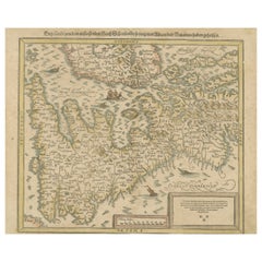
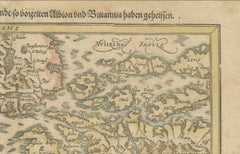
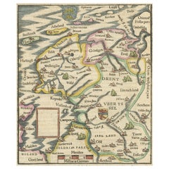
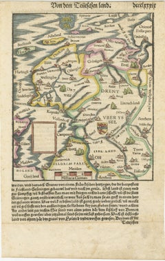
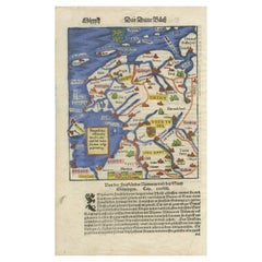
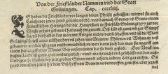
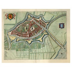
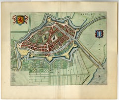
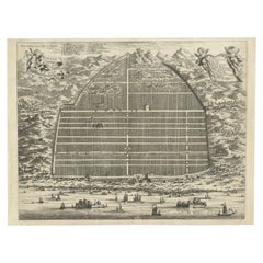
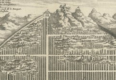
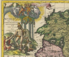
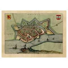
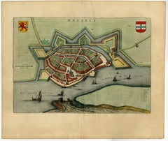
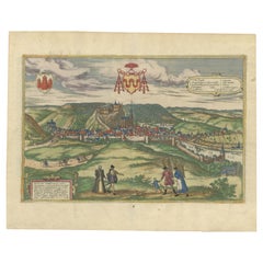
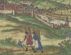
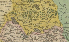
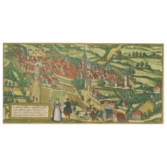
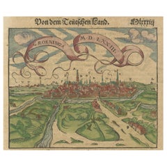
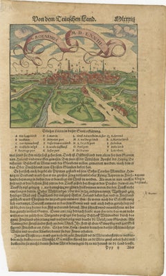
Cosmographia Universalis

Sebastian Münster's 16th Century Map of the British Isles, ca.1590
Located in Langweer, NL
from 'Cosmographia Universalis' This map is a historical representation of the British Isles
Category

Antique 16th Century Maps

Materials

Paper

Sebastian Münster's 16th Century Map of the British Isles, ca.1590
$612 Sale Price
20% Off
H 13 in W 16.07 in D 0 in
Friesland, Groningen and Overijssel – Rare Woodcut Map by Münster, c. 1550
Located in Langweer, NL
use of color. Cartographer:*Sebastian Münster Date: circa 1550 Publication: *Cosmographia Universalis
Category

Antique 16th Century Maps

Materials

Paper

Friesland, Groningen, Drenthe, Overijssel – Antique Map by Seb. Münster, 1574
Located in Langweer, NL
(1488–1552), was published in 1574 in the *Cosmographia Universalis*, the most significant and famous
Category

Antique 16th Century Maps

Materials

Paper

Recent Sales

Hermes Scarf Cosmographia Universalis 90 cm Silk Orange Carre universe
By Hermès
Located in West Chester, PA
Hermes Cosmographia Universalis Measures 36" x 36" Size is 90cm Full size scarf Scarf in silk twill
Category

2010s French Scarves

Hermes Silk Scarf Costume de Fête – Noir – Bleu Azur - New / Store Tag
By Hermès
Located in Ottawa, CA
oeuvre (e.g., Animapolis, Cosmographia Universalis), blending folkloric references, cartography and
Category

2010s French Scarves

Hermes Cosmographia Universalis scarf 90 turquoise jaune rose
By Hermès
Located in Philadelphia, PA
Hermes Cosmographia Universalis Silk Scarf 90 in new with tag condition. Original silk screen
Category

2010s Scarves

Hermès Silk Scarf Cosmographia Universalis Pink Red White 90 cm
By Hermès
Located in Corcoué Sur Logne, Loire-Atlantique
Absolutely Gorgeous Authentic Hermès Scarf Pattern: "Cosmographia Universalis" Designed by Jan
Category

2010s French Scarves

Brand New- Hermès Shawl 140 “Cosmographia Universalis” in cashmere and silk
By Hermès
Located in Paris, IDF
This elegant Hermes "Cosmographia Universalis" shawl in various blues is printed on the house's
Category

21st Century and Contemporary French Scarves

People Also Browsed

Ancient Crossroads: Albania to Assyria in Antiquity, Published in 1880
Located in Langweer, NL
The map titled "ALBANIA, IBERIA, COLCHIS, ARMENIA, MESOPOTAMIA, BABYLONIA, ASSYRIA" portrays the ancient regions that would encompass parts of modern-day Eastern Turkey, Armenia, Aze...
Category

Antique 1880s Maps

Materials

Paper

Set of 12 Antique Mycology Prints of Various Fungi by Barla, circa 1890
Located in Langweer, NL
Set of twelve antique mycology prints depicting various fungi / mushrooms. These prints originate from 'Flore mycologique illustrée: les champignons des Alpes-Maritimes' by J.B. Barla.
Category

Antique Late 19th Century French Prints

Materials

Paper

Set of 12 Antique Mycology Prints of Various Fungi by Barla, circa 1890
$753 Sale Price / set
40% Off
H 13.39 in W 10.24 in D 0.02 in
Great Antique Bird's-Eye View Plan of Brielle by Blaeu in The Netherlands, 1649
Located in Langweer, NL
Antique print, titled: 'Briela.' Bird's-eye view plan of Brielle in The Netherlands. With key to locations and coats of arms. Text in Dutch on verso. This plan originates from th...
Category

Antique 1640s Maps

Materials

Paper

Large Antique Map of the State of Texas, 1861
Located in Langweer, NL
Antique map titled 'Johnson's New Map of the State of Texas' Large map of Texas, shows railroads, wagon roads, the U.S. Mail Route, rivers, ports, large towns, and villages of the mi...
Category

Antique Mid-19th Century American Maps

Materials

Paper

Large Antique Map of the State of Texas, 1861
$468 Sale Price
20% Off
H 18.04 in W 26.58 in D 0.02 in
Antique Map of the North Sea From the English Channel to Norway & Sweden, 1746
Located in Langweer, NL
Antique map titled 'A correct Chart of the German Ocean from the North of Scotland to the Start Point, on the Coast of Great Britain; and from So. Bygden on ye coast of Norway, to C....
Category

Antique 1740s Maps

Materials

Paper

Rare Decorative Leaded-Glass Window Picturing The Queen of the East, ca. 1899
Located in Langweer, NL
Original Antique Leaded-glass window depicting "Batavia, Queen of the East' & the Coat of Arms of Batavia, in wooden door, execution Atelier van Gebrand Glas 't Prinsenhof - Jan Scho...
Category

Antique 1890s Dutch Art Nouveau Antiquities

Materials

Lead

Rare Decorative Leaded-Glass Window Picturing The Queen of the East, ca. 1899
$29,250 Sale Price
35% Off
H 43.71 in W 19.69 in D 0.79 in
Antique Map of Virginia, with Inset Map of the South Western Continuation
Located in Langweer, NL
Antique map titled 'Virginia'. Original antique map of Virginia, United States. With inset map of the south western continuation of Virginia. This print originates from 'Encyclopaedi...
Category

Antique Late 19th Century Maps

Materials

Paper

Antique Map of Virginia, with Inset Map of the South Western Continuation
$277 Sale Price
20% Off
H 8.27 in W 10.63 in D 0.02 in
Vintage Reproduction 17th Century Map of Europe, American, Cartography, Blaeuw
Located in Hele, Devon, GB
This is a vintage reproduction map of Europe. An American, paper stock cartography print in frame after the work by Blaeuw, dating to the late 20th century, circa 1970. Fascinating ...
Category

Late 20th Century Central American Mid-Century Modern Maps

Materials

Glass, Wood, Paper

Italian Decorative Wall Panel Carved w/Helmet, Horn & Arrows, 19th Century
Located in Atlanta, GA
An Italian hand-carved wall plaque, with its original painted and gilt finish, from the 19th century. This antique wall decoration from Italy features a rectangular-shaped molded sur...
Category

Antique 19th Century Italian Decorative Art

Materials

Wood

Stunning Bird's-Eye View Plan of Hasselt by Blaeu in The Netherlands, 1649
Located in Langweer, NL
Antique print, titled: 'Hasselt.' Bird's-eye view plan of Hasselt in The Netherlands. With key to locations and coats of arms. Text in Dutch on verso. This plan originates from t...
Category

Antique 1640s Maps

Materials

Paper

Stunning Bird's-Eye View Plan of Hasselt by Blaeu in The Netherlands, 1649
$1,100 Sale Price
20% Off
H 20.08 in W 23.63 in D 0 in
17th Century Cartographic Marvel: A Detailed Engraving of Guangzhou (Kanton)
Located in Langweer, NL
This engraving of Guangzhou ("Kanton") is from a French edition of Olfert Dapper's work. The French edition titled "Description de l’Empire de la Chine" was published in 1674. It is ...
Category

Antique 1670s Maps

Materials

Paper

17th Century Cartographic Marvel: A Detailed Engraving of Guangzhou (Kanton)
$1,052 Sale Price
20% Off
H 12.01 in W 15.52 in D 0.01 in
16th-Century Map of the Ottoman Empire and Near East: Turcici Imperii Descriptio
Located in Langweer, NL
Title: Original 16th-Century Map of the Ottoman Empire and Near East: *Turcici Imperii Descriptio* by Ortelius, 1571 This rare copperplate engraving, Turcici Imperii Descriptio, i...
Category

Antique 16th Century European Maps

Materials

Paper

16th-Century Map of the Ottoman Empire and Near East: Turcici Imperii Descriptio
$1,530 Sale Price
20% Off
H 14.97 in W 19.69 in D 0.01 in
Rare Antique Map of the Dutch East Indies 'Indonesia', 1774
Located in Langweer, NL
Rare decorative engraved map of the Dutch East Indies, or nowadays Indonesia. Title (in old Dutch): NIEUWE EN NAUKEURIGE KAART DER OOST-INDISCHE EILANDEN volgens de laatste ontde...
Category

Antique 1770s Maps

Materials

Paper

Rare Antique Map of the Dutch East Indies 'Indonesia', 1774
$1,148 Sale Price
20% Off
H 23.82 in W 18.12 in D 0 in
Antique Bird's-Eye View of Hangzhou (China) by Matthäus Merian, 1638
Located in Langweer, NL
This is an exquisite antique bird's-eye view map of Hangzhou, historically referred to as "Xuntien or Quinzay," from the first edition of Matthäus Merian's publication in 1638. This ...
Category

Antique 1630s Maps

Materials

Paper

Engraving of St. Gallen and its Monastery, from Civitates Orbis Terrarum (1575)
Located in Langweer, NL
Description of the Engraving: Braun & Hogenberg’s "S. Galli Opp. et Monasterium Heluetiorum" from Civitates Orbis Terrarum (1575) This is an original, hand-colored copper engraving ...
Category

Antique 16th Century Maps

Materials

Paper

Bird’s-Eye View of Basel from Braun & Hogenberg’s Civitates Orbis Terrarum, 1575
Located in Langweer, NL
Bird’s-Eye View of Basel from Braun & Hogenberg’s "Civitates Orbis Terrarum" (Circa 1572-1617) This highly detailed map of Basel is a bird's-eye view, originally based on Sebastian ...
Category

Antique 16th Century Maps

Materials

Paper

Get Updated with New Arrivals
Save "Cosmographia Universalis", and we’ll notify you when there are new listings in this category.