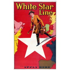
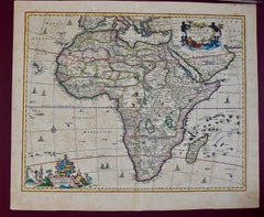
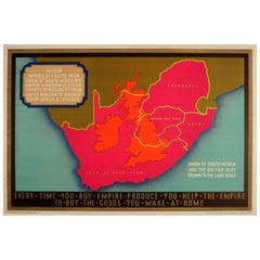
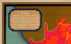
Map Colorful

to
47
76
63
69
47
34
31
27
23
23
18
14
14
12
10
10
7
7
6
6
6
5
4
4
3
3
3
2
2
2
2
1
1
1
1
1
1
28
3
2
2
2
Sort By
Hot Air Balloon Gondola Pub Bar Dining Table Rattan Basket Hand Painted Map

Hot Air Balloon Gondola Pub Bar Dining Table Rattan Basket Hand Painted Map

Located in Dayton, OH

a colorful birdseye continental map view. At the center is handmade lamp fashioned to look like the

Category

Vintage 1980s Dining Room Tables

Materials

Rattan, Rope, Hardwood, Paint

Halston Beaded Tulle Jacket

Halston Beaded Tulle Jacket

By Halston

Located in New York, NY

paillettes and floral sequins are spaced around a colorful,festive map pattern. Sleeves are a unusual

Category

1980s American Bolero Jackets

Joy of Womanhood
Joy of Womanhood

Joy of Womanhood

Located in Ibadan, Oyo

aerial perspective while facial contours are colorfully mapped out with divisive lines. A technique

Category

21st Century and Contemporary Contemporary Figurative Prints

Materials

Canvas, Linen, Ink, Linocut

Elders of the Land
Elders of the Land

Elders of the Land

Located in Ibadan, Oyo

are colorfully mapped-out with divisive lines. A technique combination that is still largely

Category

21st Century and Contemporary Contemporary Figurative Prints

Materials

Canvas, Linen, Ink, Linocut

Likeminded
Likeminded

Likeminded

Located in Ibadan, Oyo

aerial perspective while facial contours are colorfully mapped-out with divisive lines. A technique

Category

21st Century and Contemporary Contemporary Figurative Prints

Materials

Canvas, Linen, Ink

America Needs McGovern, He Can Put Us Together

America Needs McGovern, He Can Put Us Together

By Larry Rivers

Located in New York, NY

work, featuring a smiling portrait of George McGovern underneath a colorful map of the United States

Category

1970s Pop Art Abstract Prints

Materials

Lithograph

Mexican War Era Scrolling Broadside Featuring the 1st 11 Presidents, ca 1845-46

Mexican War Era Scrolling Broadside Featuring the 1st 11 Presidents, ca 1845-46

Located in York County, PA

colorful maps and historical American images, hung in schools, public buildings and the like. Some, like

Category

Antique Late 19th Century American Political and Patriotic Memorabilia

Materials

Paper

Antique Map of the Philippine Islands and Hawaii, 1903

Antique Map of the Philippine Islands and Hawaii, 1903

Located in Langweer, NL

Colorful double page map, centre fold as issued. Map number and title on verso. Published in

Category

Early 20th Century Maps

Original John Dunn's Ordnance Map of London, 19th Century

Original John Dunn's Ordnance Map of London, 19th Century

Located in St Annes, Lancashire

Fabulous colorful map of London in a glazed vintage frame. Original color. Not dated but

Category

Antique Late 19th Century English Victorian Maps

Materials

Paper

A Set of Three Original Antique Maps of Turkey

A Set of Three Original Antique Maps of Turkey

Located in Langweer, NL

Europe by Levasseur, '1875' Original Colorful Antique Map of Turkey in Asia, 1817 The collage presents

Category

Antique Mid-19th Century Maps

Materials

Paper

19th Century Hand-Colored Map of Africa by Henry Tanner

19th Century Hand-Colored Map of Africa by Henry Tanner

By Henry Schenck Tanner

Located in Alamo, CA

Monrovia. This colorful map of Africa is presented in a polished burl wood frame with a double mat; the

Category

Antique Mid-19th Century American Maps

Materials

Paper

1864 Johnson's Map of the World on Mercator's Projection, Ric.B009

1864 Johnson's Map of the World on Mercator's Projection, Ric.B009

Located in Norton, MA

A.J. Johnson. These maps are some of the most colorful and accurate maps produced in the 1860's, their

Category

Antique 19th Century Dutch Maps

Materials

Paper

"Africae Accurata", a Hand-Colored 17th Century Map of Africa by Visscher

"Africae Accurata", a Hand-Colored 17th Century Map of Africa by Visscher

By Nicolaes Visscher II

Located in Alamo, CA

Nicolaes Visscher, published in Amsterdam in 1680. This beautiful, colorful and detailed map is embellished

Category

Antique Late 17th Century Dutch Maps

Materials

Paper

Large Original Antique City Plan of Detroit, USA, 1894

Large Original Antique City Plan of Detroit, USA, 1894

By Rand McNally & Co.

Located in St Annes, Lancashire

Fabulous colorful map of Detroit Original color By Rand, McNally & Co. Published, 1894

Category

Antique 1890s American Maps

Materials

Paper

Large Original Antique City Plan of Boston, USA. 1894

Large Original Antique City Plan of Boston, USA. 1894

By Rand McNally & Co.

Located in St Annes, Lancashire

Fabulous colorful map of Boston Original color By Rand, McNally & Co. Published, 1894

Category

Antique 1890s American Maps

Materials

Paper

Large Original Antique City Plan of Chicago, USA. 1894

Large Original Antique City Plan of Chicago, USA. 1894

By Rand McNally & Co.

Located in St Annes, Lancashire

Fabulous colorful map of Chicago Original color By Rand, McNally & Co. Published, 1894

Category

Antique 1890s American Maps

Materials

Paper

Original Antique City Plan of Milwaukee, USA, 1894

Original Antique City Plan of Milwaukee, USA, 1894

By Rand McNally & Co.

Located in St Annes, Lancashire

Fabulous colorful map of Milwaukee Original color By Rand, McNally & Co. Published, 1894

Category

Antique 1890s American Maps

Materials

Paper

Original Antique City Plan of Toledo, Ohio USA, circa 1900

Original Antique City Plan of Toledo, Ohio USA, circa 1900

By Rand McNally & Co.

Located in St Annes, Lancashire

Fabulous colorful map of Toledo Original color By Rand, McNally & Co. Published circa 1900

Category

Antique Early 1900s American Maps

Materials

Paper

Original Antique City Plan of St Joseph, Missouri, USA, 1894

Original Antique City Plan of St Joseph, Missouri, USA, 1894

By Rand McNally & Co.

Located in St Annes, Lancashire

Fabulous colorful map of St Joseph Original color By Rand, McNally & Co. Published, 1894

Category

Antique 1890s American Maps

Materials

Paper

Large Original Antique City Plan of Indianapolis, USA, circa 1900

Large Original Antique City Plan of Indianapolis, USA, circa 1900

By Rand McNally & Co.

Located in St Annes, Lancashire

Fabulous colorful map of Indianapolis Original color By Rand, McNally & Co. Published

Category

Antique Early 1900s American Maps

Materials

Paper

Original Antique City Plan of Cleveland, Ohio, USA, circa 1900

Original Antique City Plan of Cleveland, Ohio, USA, circa 1900

By Rand McNally & Co.

Located in St Annes, Lancashire

Fabulous colorful map of Cleveland Original color By Rand, McNally & Co. Published, circa

Category

Antique Early 1900s American Maps

Materials

Paper

Large Original Antique City Plan of Washington D.C. USA, 1894

Large Original Antique City Plan of Washington D.C. USA, 1894

By Rand McNally & Co.

Located in St Annes, Lancashire

Fabulous colorful map of Washington DC Original color By Rand, McNally & Co. Published

Category

Antique 1890s American Maps

Materials

Paper

Original Antique City Plan of New Orleans, USA, 1894

Original Antique City Plan of New Orleans, USA, 1894

By Rand McNally & Co.

Located in St Annes, Lancashire

Fabulous colorful map of New Orleans Original color By Rand, McNally & Co. Published, 1894

Category

Antique 1890s American Maps

Materials

Paper

Large Original Antique City Plan of Brooklyn, New York, USA, 1894

Large Original Antique City Plan of Brooklyn, New York, USA, 1894

By Rand McNally & Co.

Located in St Annes, Lancashire

Fabulous colorful map of Brooklyn & Vicinity Original color By Rand, McNally & Co

Category

Antique 1890s American Maps

Materials

Paper

Original Antique City Plan of Omaha, Nebraska, USA, circa 1900

Original Antique City Plan of Omaha, Nebraska, USA, circa 1900

By Rand McNally & Co.

Located in St Annes, Lancashire

Fabulous colorful map of Omaha, Nebraska Original color By Rand, McNally & Co. Published

Category

Antique Early 1900s American Maps

Materials

Paper

Large Original Antique City Plan of New York City, USA, 1894

Large Original Antique City Plan of New York City, USA, 1894

By Rand McNally & Co.

Located in St Annes, Lancashire

Fabulous colorful map of New York City Original color By Rand, McNally & Co. Published

Category

Antique 1890s American Maps

Materials

Paper

Large Original Antique City Plan of Washington DC, USA, circa 1900

Large Original Antique City Plan of Washington DC, USA, circa 1900

By Rand McNally & Co.

Located in St Annes, Lancashire

Fabulous colorful map of Washington DC Original color By Rand, McNally & Co. Published

Category

Antique Early 1900s American Maps

Materials

Paper

Original Antique City Plan of New Orleans, USA, circa 1900

Original Antique City Plan of New Orleans, USA, circa 1900

By Rand McNally & Co.

Located in St Annes, Lancashire

Fabulous colorful map of New Orleans Original color By Rand, McNally & Co. Published

Category

Antique Early 1900s American Maps

Materials

Paper

Large Original Antique City Plan of St Louis, USA, circa 1900

Large Original Antique City Plan of St Louis, USA, circa 1900

By Rand McNally & Co.

Located in St Annes, Lancashire

Fabulous colorful map of St Louis, Missouri Original color By Rand, McNally & Co

Category

Antique Early 1900s American Maps

Materials

Paper

Original Antique City Plan of Toledo, Ohio, USA, 1894

Original Antique City Plan of Toledo, Ohio, USA, 1894

By Rand McNally & Co.

Located in St Annes, Lancashire

Fabulous colorful map of Toledo Original color By Rand, McNally & Co. Published, 1894

Category

Antique 1890s American Maps

Materials

Paper

Original Antique City Plan of Louisville, Kentucky. USA. 1894

Original Antique City Plan of Louisville, Kentucky. USA. 1894

By Rand McNally & Co.

Located in St Annes, Lancashire

Fabulous colorful map of Louisville Original color By Rand, McNally & Co. Published, 1894

Category

Antique 1890s American Maps

Materials

Paper

Large Original Antique City Plan of Cincinnati, USA, circa 1900

Large Original Antique City Plan of Cincinnati, USA, circa 1900

By Rand McNally & Co.

Located in St Annes, Lancashire

Fabulous colorful map of Cincinnati, Ohio. Original color By Rand, McNally & Co. Published

Category

Antique Early 1900s American Maps

Materials

Paper

Vintage 'Newsmap' of Malaysia and Sumatra '1945'

Vintage 'Newsmap' of Malaysia and Sumatra '1945'

Located in Langweer, NL

contains a colorful large map of northern Sumatra and southern Malaysia, providing topography detail with a

Category

20th Century Maps

Materials

Paper

Colorful, Abstract painting, Liz Tran, Heart Map Process

Colorful, Abstract painting, Liz Tran, Heart Map Process

By Liz Tran

Located in White Plains, NY

'Heart Map Process' 2018 by Seattle based abstract painter, Liz Tran. Mixed media on panel, 30 x 24

Category

2010s Abstract Expressionist Abstract Paintings

Materials

Ink, Mixed Media, Wax, Acrylic, Graphite

Botticelli Brunette, collage, colorful, mixed media, maps, woman, charcoal,

Botticelli Brunette, collage, colorful, mixed media, maps, woman, charcoal,

By Audrey Anastasi

Located in Brooklyn, NY

These collages were created first in the presence of a model, working quickly, in charcoal and pastel, and again, later, alone, furiously tearing and pasting images from magazines, v...

Category

2010s Assemblage Mixed Media

Materials

Mixed Media, Charcoal, Archival Paper

Maps by Petra Rös-Nickel - Contemporary Colorful Geometric Oil PaintingPetra Rö

Maps by Petra Rös-Nickel - Contemporary Colorful Geometric Oil PaintingPetra Rö

By Petra Rös-Nickel

Located in DE

Petra Rös-Nickel’s original paintings merge playful forms, bright colors and architectural compositions in oil and mixed media on canvas. Her contemporary artworks contain rich text...

Category

21st Century and Contemporary Abstract Abstract Paintings

Materials

Marble

America Needs McGovern, He Can Put Us Together

America Needs McGovern, He Can Put Us Together

By Larry Rivers

Located in New York, NY

work, featuring a smiling portrait of George McGovern underneath a colorful map of the United States

Category

1970s Pop Art Abstract Prints

Materials

Lithograph

Map of USA Territorial Acquisitions, 1776-1866, Edition 1956

Map of USA Territorial Acquisitions, 1776-1866, Edition 1956

Located in Madison, WI

manifest destiny. If the historical context is of less interest, the soft pastels of this map's colorful

Category

Vintage 1950s American Maps

Materials

Paper, Wood

School Chart or Pull Down Map of Geography of the Netherlands, 1950s

School Chart or Pull Down Map of Geography of the Netherlands, 1950s

Located in Hemiksem, VAN

reliefs (low, middle, high) of the Netherlands. The beautiful colors give this school map a colorful touch

Category

Vintage 1950s Belgian Mid-Century Modern Maps

Materials

Linen, Paint

Illustrated Map of the Oceans

Illustrated Map of the Oceans

Located in Los Angeles, CA

Colorful framed map of the oceans.

Category

Vintage 1950s Belgian Decorative Art

Materials

Lithograph

8 Maps of England on Belgian Linen c.1760s

8 Maps of England on Belgian Linen c.1760s

Located in Atlanta, GA

Shire. Each map has a written description of the area as well as a colorful map. These maps are

Category

Antique 18th Century and Earlier Belgian Drawings

Materials

Linen, Ink

Louis Vuitton Damier Graphite Canvas Map Print Slender Wallet

Louis Vuitton Damier Graphite Canvas Map Print Slender Wallet

By Louis Vuitton

Located in Dubai, Al Qouz 2

Made from Damier Graphite canvas, this Slender wallet by Louis Vuitton is decorated with a map of

Category

2010s French Wallets

Damien Hirst Last Supper Framed Lithograph Signed Limited Edition, 2005 Large

Damien Hirst Last Supper Framed Lithograph Signed Limited Edition, 2005 Large

By Damien Hirst

Located in Longdon, Tewkesbury

representative of Hirst’s provocative and persistently unsettling oeuvre. A colorful map, highlighting the

Category

Early 2000s English Modern Posters

Materials

Ebony

  • 1
Get Updated with New Arrivals
Save "Map Colorful", and we’ll notify you when there are new listings in this category.

Map Colorful For Sale on 1stDibs

Choose from an assortment of styles, material and more with respect to the map colorful you’re looking for at 1stDibs. A map colorful — often made from paper, fabric and linen — can elevate any home. You’ve searched high and low for the perfect map colorful — we have versions that date back to the 18th Century alongside those produced as recently as the 21st Century are available. Each map colorful bearing mid-century modern, modern or Art Deco hallmarks is very popular. Many designers have produced at least one well-made map colorful over the years, but those crafted by Rand McNally & Co., Jacques-Nicolas Bellin and Damien Hirst are often thought to be among the most beautiful.

How Much is a Map Colorful?

Prices for a map colorful start at $0 and top out at $278,500 with the average selling for $1,786.