Africa Maps By Emanuel Bowen
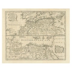
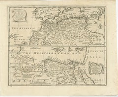
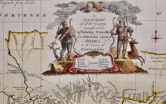
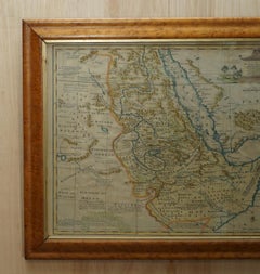
London 1744 Published Watercolour Antique Map of East Africa by Eman Bowen
Located in GB
all the Kingdoms Tributary Thereto, and bordering upon them published in 1744 by Emanuel Bowen
Category
Antique 1740s English George III Maps
Materials
Paper
H 17.52 in W 21.07 in D 0.79 in
Antique Map of Islands in the Mediterranean by Bowen, 'c.1760'
Located in Langweer, NL
Antique map titled 'Particular Draughts of some of the chief African Islands (..)'. Eight small
Category
Antique Mid-18th Century Maps
Materials
Paper
Map of the World: An Original 18th Century Hand-colored Map by E. Bowen
Located in Alamo, CA
described above, the map is in very good condition.
Emanuel Bowen (1694-1767) was a prominent British
Category
Mid-18th Century Old Masters Landscape Prints
Materials
Engraving
Europe: An Original 18th Century Hand-colored Map by E. Bowen
Located in Alamo, CA
from the Best Authorities Assisted by the Most Improved Modern Charts and Maps." by Emanuel Bowen. It
Category
Mid-18th Century Old Masters Landscape Prints
Materials
Engraving
China: An Original 18th Century Hand-colored Map by E. Bowen
Located in Alamo, CA
numerous astronomical observations" by Emanuel Bowen. It was published in 1744 in London in John Harris's
Category
Mid-18th Century Old Masters Landscape Prints
Materials
Engraving
H 15.75 in W 19.75 in
Map of the Russian Empire: An Original 18th Century Hand-colored Map by E. Bowen
Located in Alamo, CA
Improved Modern Maps and Regulated by Astronomical Observations" by Emanuel Bowen. It was published in 1744
Category
Mid-18th Century Old Masters Landscape Prints
Materials
Engraving
Map of the East Indies: An Original 18th Century Hand-colored Map by E. Bowen
Located in Alamo, CA
the map is otherwise in very good condition.
Emanuel Bowen (1694-1767) was a prominent British
Category
Mid-18th Century Old Masters Landscape Prints
Materials
Engraving
Siberia as Explored by Behring: Original 18th Century Hand-colored Map by Bowen
Located in Alamo, CA
map is otherwise in very good condition.
Emanuel Bowen (1694-1767) was a prominent British engraver
Category
Mid-18th Century Old Masters Landscape Prints
Materials
Engraving
Mediterranean and Adriatic Seas: Original 18th Century Hand-colored Map by Bowen
Located in Alamo, CA
right and lower left and right corners. The map is otherwise in very good condition.
Emanuel Bowen
Category
Mid-18th Century Old Masters Landscape Prints
Materials
Engraving
Antique Map of 'African' Islands in the Mediterranean Sea and The Atlantic, 1747
Located in Langweer, NL
Antique map titled 'Particular draughts of some of the chief African Islands in the Mediterranean
Category
Antique 18th Century Maps
Materials
Paper
H 19.49 in W 15.16 in D 0 in
Rare Original Double Hemisphere World Map with Allegorical Figures, 1785
Located in Langweer, NL
' of Maastricht. After 1769 he published maps based on Emanuel Bowen. In 1785 all his maps were
Category
Antique 1780s Maps
Materials
Paper
H 17.05 in W 23.23 in D 0 in
People Also Browsed
Small Set Antique Draughts / Checkers / Backgammon Counters
Located in Bath, GB
A beautiful boxed set of gaming counters, perfect for Draughts / Checkers / Backgammon / Triktrac.
The counters are made from turned wood, all in very good condition each measuring ...
Category
Vintage 1910s British Edwardian Games
Materials
Wood
19th Century Pair of Mary Gregory Vases with Hunting Scenes
By Mary Gregory
Located in High Point, NC
Pair of 19th century handblown amethyst glass vases with central designs on the front surrounded by a floral border and hand-painted scenes depicting children hunting with dogs and d...
Category
Antique Late 19th Century American Victorian Vases
Materials
Enamel
Large and Unique Antique French Boiserie with Covered Alcove, 17th Century
Located in Dallas, TX
This beautiful section of boiserie has been carved from softwood in the 17th century (upper section pieces only). It has been completely cleaned (stripped) and clear waxed at some po...
Category
Antique 17th Century French Panelling
Materials
Softwood
H 97.13 in W 110.63 in D 14 in
1889 The Blue Fairy Book
By Andrew Lang
Located in Bath, GB
A superb copy of this sought-after fairy book by Andrew Lang, the first volume in his colourful series.
The sought after first edition, first impression.
Illustrated with a frontis...
Category
Antique 1890s British Books
Materials
Paper
Combination Board Game of Marble Solitaire and Tiddlywinks, circa 1925
Located in Lincoln, Lincolnshire
This is a complete combination board game of marble solitaire and tiddlywinks, dating to the early 20th century.
This is a most unusual and very decorative game set with a beautif...
Category
Early 20th Century English Folk Art Games
Materials
Glass, Hardwood
No Reserve
H 1.5 in Dm 14.44 in
IMPORTANT PORTUGUESE ORATORY WITH CALVARY 17th Century
By Europa Antiques
Located in Madrid, ES
ORATORY WITH NICHE
Portuguese, niche from the 17th century
in carved and gilded wood, decorated with plant motifs, angels and birds.
Box in mahogany wood.
Interior with Calvary - ...
Category
Antique 17th Century Portuguese Baroque Religious Items
Materials
Silver
Huge Monumental Victorian Taxidermy Dome with Colorfull Tropical Birds, C. 1850
Located in Amsterdam, NL
A monumental Victorian taxidermy dome, measuring H. 90 cm, with a wide variety of Tropical birds, of which many male and female pairs
England, late 19th century
Amongst the birds...
Category
Antique Mid-19th Century English Victorian Taxidermy
Materials
Animal Skin, Glass, Plaster, Feathers
H 35.44 in W 23.63 in D 15.75 in
17th Century Guilloche Frame in Ebonized Finish Wood
Located in Milan, IT
17th century
Guilloche frame in ebonized finish
Wood, cm 89 x 79
Referable to the seventeenth century, the ebonized frame examined has a carving called guilloché, whose band loo...
Category
Antique 17th Century Italian Picture Frames
Materials
Wood
The Dardanelles Strait: A Strategic Passage in a Colored Lithograph, 1853
Located in Langweer, NL
The text on this colored lithograph is Italian, and it relates to the geography of the Dardanelles straits.
"Strait of the Dardanelles. Milan, published by lit. Corbetta. (to accom...
Category
Antique 1850s Prints
Materials
Paper
Free Shipping
H 18.39 in W 6.7 in D 0 in
19th Century Travelling Marble Solitaire Game with 33 Handmade Clay Marbles
Located in Lincoln, Lincolnshire
This is an original and complete game of travelling marble solitaire from the 19th century with 33 old clay and stone marbles, circa 1870.
This two-piece board has a fairly small di...
Category
Antique 19th Century English Victorian Games
Materials
Stone
Stunning quality antique Mary Gregory blue glass vase
Located in Ipswich, GB
Stunning quality antique Mary Gregory blue glass vase having a stunning quality Mary Gregory blue glass vase with white enamel decoration.
D. 1890
Category
Antique Early 19th Century Vases
Materials
Glass
Large Original Vintage Map of The Pacific Islands Including Hawaii
Located in St Annes, Lancashire
Great map of The Pacific Islands
Unframed
Original color
By John Bartholomew and Co. Edinburgh Geographical Institute
Published, circa 1920
Free shipping.
Category
Vintage 1920s British Maps
Materials
Paper
No Reserve
H 18 in W 23 in D 0.07 in
Stunning quality antique Victorian Mary Gregory green glass ewer
Located in Ipswich, GB
Stunning quality antique Victorian Mary Gregory green glass ewer having a stunning quality Mary Gregory green glass ewer with white enamel decoration of a girl surrounded by trees ha...
Category
Antique Early 19th Century Victorian Glass
Materials
Glass
Free Shipping
H 9.85 in W 4.73 in D 4.73 in
Antique Victorian quality Mary Gregory cranberry glass vase
Located in Ipswich, GB
Antique Victorian quality Mary Gregory cranberry glass vase having gilt and white enamel decoration of Mary Gregory surrounded by flowers in a garden
Category
Antique Early 19th Century Victorian Glass
Materials
Glass
Free Shipping
H 7.88 in W 5.12 in D 5.12 in
Northern Italy: A 16th Century Hand-colored Map by Abraham Ortelius
By Abraham Ortelius
Located in Alamo, CA
This is a framed 16th century hand-colored copperplate map of northern Italy entitled "Veronae Urbis Territorium a Bernardo Bragnolo Descriptium" by Abraham Ortelius from his atlas "...
Category
16th Century Old Masters Landscape Prints
Materials
Engraving
H 21.5 in W 28 in D 0.75 in
Ireland: A Framed 17th Century Hand-colored Map by Jan Jannson
By Johannes Janssonius
Located in Alamo, CA
This is a 17th century hand-colored map entitled "Hibernia Regnum Vulgo Ireland" by Johannes Janssonius's (Jan Jansson), published in Amsterdam in 1640. This highly detailed map depi...
Category
Mid-17th Century Old Masters Landscape Prints
Materials
Engraving
H 17.88 in W 22 in D 0.75 in
Recent Sales
The Atlantic Ocean, Americas, Africa and Europe: Hand-colored 18th C. Bowen Map
Located in Alamo, CA
Western or Atlantic Ocean Drawn from Surveys and most approved Maps & Charts" by Emanuel Bowen. It was
Category
Mid-18th Century Old Masters Landscape Prints
Materials
Engraving
Mainland Greece & Islands: An Original 18th Century Hand-colored Map by Bowen
Located in Alamo, CA
involve the map. The map is otherwise in excellent condition.
Emanuel Bowen (1694-1767) was a prominent
Category
Mid-18th Century Old Masters Landscape Prints
Materials
Engraving
Get Updated with New Arrivals
Save "Africa Maps By Emanuel Bowen", and we’ll notify you when there are new listings in this category.
Africa Maps By Emanuel Bowen For Sale on 1stDibs
You are likely to find exactly the africa maps by emanuel bowen you’re looking for on 1stDibs, as there is a broad range for sale. Finding the perfect africa maps by emanuel bowen may mean sifting through those created during different time periods — you can find an early version that dates to the 18th Century and a newer variation that were made as recently as the 18th Century. Artworks like these of any era or style can make for thoughtful decor in any space, but a selection from our variety of those made in engraving can add an especially memorable touch.
How Much is a Africa Maps By Emanuel Bowen?
The price for a africa maps by emanuel bowen in our collection starts at $360 and tops out at $2,653 with the average selling for $1,175.
More Ways To Browse
Herman Mile
East Coast Australia Charts
Tunisia Antique Map
Azores Map
Pt Reyes
Old Cypriot Maps
Golden Tradewinds
Uruguay Antique Map
Colombia Map Antique
Ecuador Antique Map
Victor Levasseur On Sale
Panama Antique Map
Antique Iowa Map
Antique Vermont Maps
Wisconsin Map
Buenos Ayres
Antique Map Ontario
Tunisia Antique Map