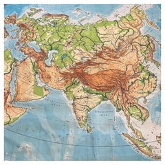
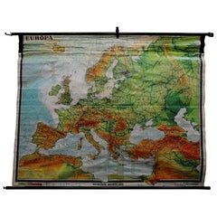
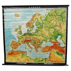
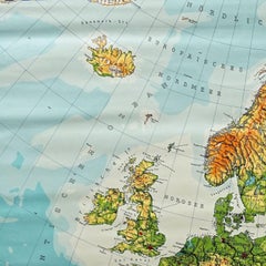
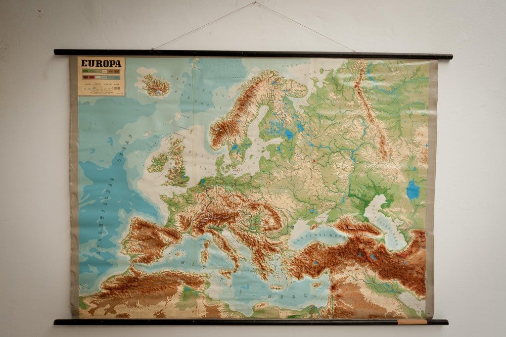
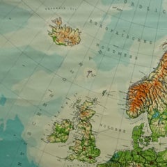
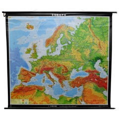
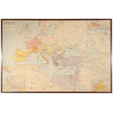
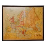
Huge Europe and Asia Vintage Wall Map
Located in San Diego, CA
A huge Europe and Asia vintage wall map, circa 1950s. The map is in fair vintage condition and
Category
Mid-20th Century American Vintage Europe Map
Materials
Paper
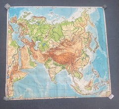
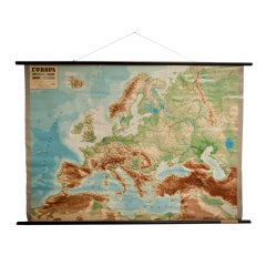
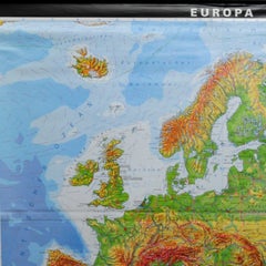
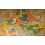
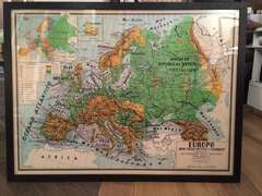
Huge Europe and Asia Vintage Wall Map
Located in San Diego, CA
A huge Europe and Asia vintage wall map, circa 1950s. The map is in fair vintage condition and
Paper
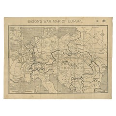
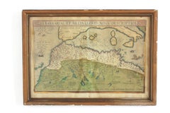
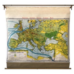
Eason's War Map of Europe, circa 1914
Located in Langweer, NL
Antique map titled 'Eason's War Map of Europe'. Printed in Ireland. Source unknown, to be
Paper


$1,254
H 30.32 in W 38.39 in D 1.38 in
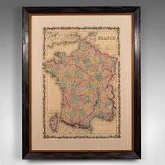
Vintage Reproduction 17th Century Map of Europe, American, Cartography, Blaeuw
Located in Hele, Devon, GB
This is a vintage reproduction map of Europe. An American, paper stock cartography print in frame
Glass, Wood, Paper
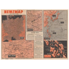
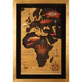
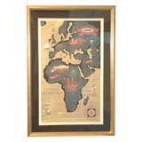
Antique Map of the War Situation in Europe and Asia, 1944
Located in Langweer, NL
, measuring nearly 4 feet by 3 feet, includes five inset maps of the war situation in both Europe and Asia
Paper
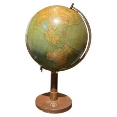
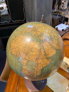
European Vintage Earth Globe on Stand with Compass
Located in Sofia, BG
Vintage handmade world globe standing on a base with small compass in the bottom. The piece is in fare condition with no restaurations ever made. France, circa 1950
Plastic, Paper
$882
H 22.05 in W 16.15 in
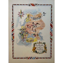
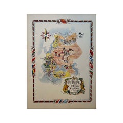
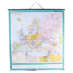
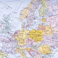
Jacques Liozu's 1951 illustrated map of Central and Eastern Europe
By Jacques Liozu
Located in PARIS, FR
Jacques Liozu's 1951 illustrated map of Central and Eastern Europe is a cartographic work of great
Paper, Lithograph
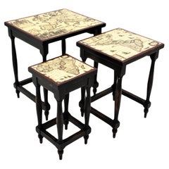
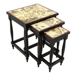
Nesting Tables in Wood with Map Top, France, 1940s
Located in Barcelona, ES
turned wood structures with beautiful lacquered maps on the tops. The largest of the three has an Europe
Wood
$329Sale Price|20% Off
H 44.1 in W 32.68 in D 0 in
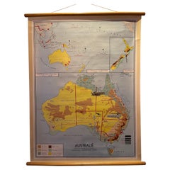
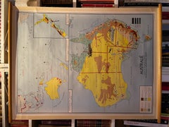
Decorative Vintage Print, Dutch Chart of Australia, 1st Edition, 1952
Located in Langweer, NL
The vintage school chart of Australia titled "Australië," created by W. Bakker & H. Rush and published in 1952: **Title**: Australië **Creators**: W. Bakker & H. Rush **Publication ...
Canvas
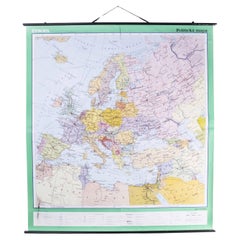
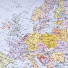
Late 20th Century Educational Geographic Map - European Countries
Located in Hook, Hampshire
Late 20th Century Educational Geographic Map – European Countries Late 20th Century Educational
Cotton
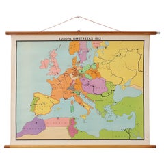
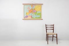
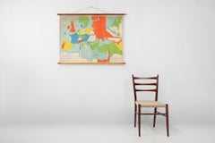
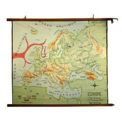
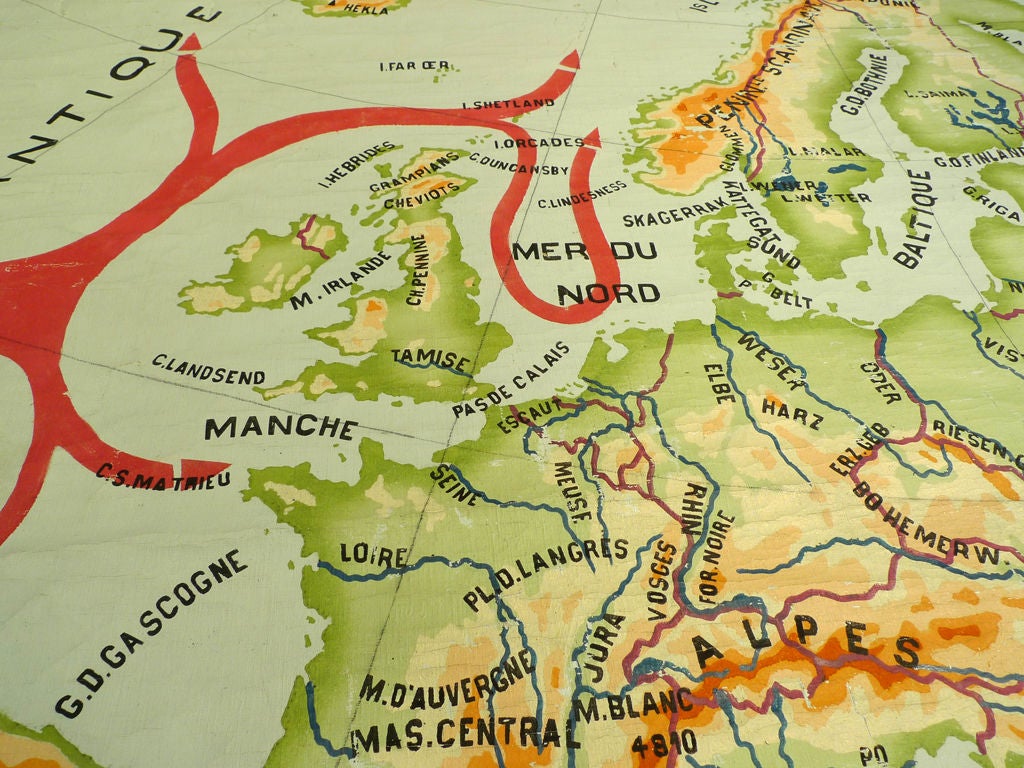
Vintage historical wall map of Europe around 1812, Belgium 1950s
Located in Meulebeke, BE
Belgium / 1950 / school map Europe 1812 / canvas, wood / Mid-century / vintage Beautiful vintage
Canvas, Wood

Vintage school wall map of Europe 1815-1871, Belgium 1950s
Located in Meulebeke, BE
Belgium / 1950 / school map Europe 1815-1871 / canvas, wood / Mid-century / vintage Vintage school
Canvas, Wood

$2,045
H 35.04 in W 43.71 in D 0.04 in
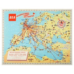
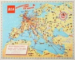
Original Vintage Poster BEA British European Airways International Air Route Map
Located in London, GB
Original vintage travel advertising poster for BEA British European Airways International Air
Paper
$650 / set
H 28.5 in W 6 in D 7 in
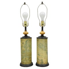
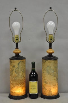
Vintage Regency Style European Old World Map Wrapped Cylinder Table Lamps - Pair
Located in Philadelphia, PA
Vintage Regency Style European Old World Map Wrapped Lacquered Cylinder Table Lamps with Interior
Metal
$1,773
H 39.38 in W 25.6 in D 0.04 in
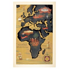
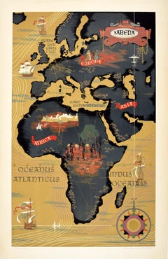
Original Vintage Poster Sabena Belgian Airlines To Europe Asia Africa Travel Map
Located in London, GB
Original vintage pictorial travel map poster advertising Sabena Belgian Airlines flights to Europe
Paper

Hand Colored Framed Map Print of North Africa
By Abraham Ortelius
Located in Barcelona, ES
Original antique map of North Africa Antique framed map print titled 'Barbariae et Biledulgerid
Giltwood, Paper
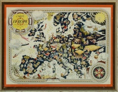
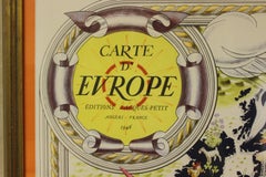
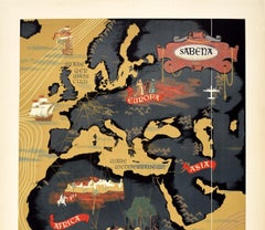
Carte D'Europe
Located in Bristol, CT
Classic colour French post-war c1946 map of Western Europe by Pierre Herault (LR) Editions Jacque
Lithograph
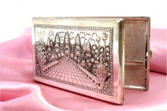
Silver case with floral and Taj Mahal reliefs, map on reverse
Located in Porto, PT
Description: Silver cigarette case with floral and Taj-Mahal reliefs and reverse mapped with
Silver

$1,179
H 36.62 in W 28.35 in D 1.38 in
Large Vintage France Map, Continental, Historical Cartography, Late 20th Century
Located in Hele, Devon, GB
This is a large vintage map of France. A Continental, framed example of historical cartography
Glass, Wood, Paper
$3,636
H 20.08 in W 47.84 in D 24.02 in
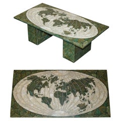
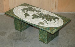
MID CENTURY MODERN 1950's ITALIAN MARBLE & ONYX WORLD MAP COFFEE COCKTAIL TABLE
Located in West Sussex, Pulborough
Italy circa 1950's World Map coffee or Cocktail table in Marble and Onyx Please note the delivery fee
Onyx, Marble

$1,500
H 20.08 in W 28.35 in D 0.04 in
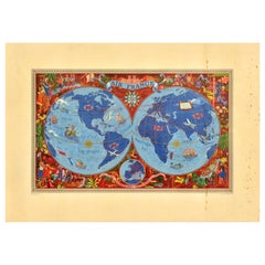
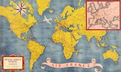
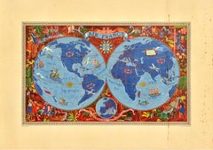
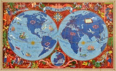
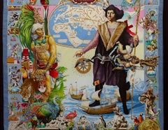
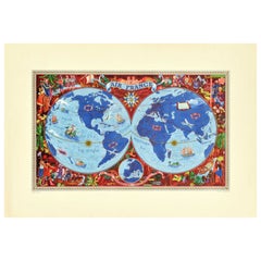
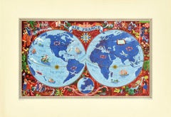
Original Vintage Travel Poster Air France Planisphere Illustrated Map Boucher
By Lucien Boucher
Located in London, GB
the top, a detailed map of Europe with the tagline - on the wings of Air France discover the world on
Paper
$1,176
H 25.6 in W 17.72 in
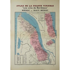
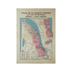
1941 original map "Les vins de Bordeaux - Médoc, Haut-Médoc" by Larmat
Located in PARIS, FR
darkest periods in European history. The Larmat map remains highly sought after by collectors, wine
Paper, Lithograph
$1,176
H 25.6 in W 17.72 in
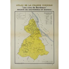
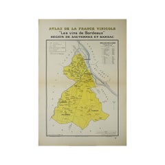
1941 original map "Les vins de Bordeaux - Régions de Sauternes" by Larmat
Located in PARIS, FR
. During the difficult context of World War II, when much of Europe was under stress, this map was produced
Paper, Lithograph
$1,303
H 25.6 in W 39.77 in D 0.04 in
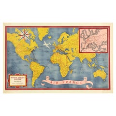
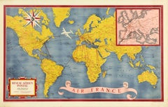
Original Vintage Travel Poster Air France World Map Postal Network Reseau Aerian
Located in London, GB
Original vintage Air France map poster - Air France Reseau Aerian Postal / Air France Postal
Paper
$4,773
H 41.34 in W 29.93 in D 0.04 in
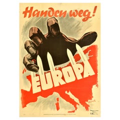
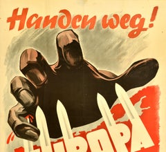
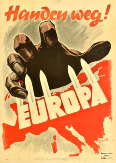
Original Vintage WWII Poster Handen Weg! Europa Hands Off Europe War Netherlands
Located in London, GB
dramatic illustration depicting a giant hand grasping at the map of Europe defending itself with swords on
Paper
$150
H 1.5 in Dm 3.5 in
Scandinavian Modern Brutalist Iittala Aslak Tea light Holder by Tapio Wirkkala
By Tapio Wirkkala, Iittala
Located in Chicago, IL
which Iittala was known for. This one interestingly has a map of Europe/Asia and Australia in low
Art Glass
$150
H 1.5 in Dm 6.5 in
Scandinatian Modern Brutalist Iittala Aslak Vessel Tapio Wirkkala Finland 1970s
By Tapio Wirkkala, Iittala
Located in Miami, FL
. This one designed with a map of Europe prominently displayed, in relief on the base, in the center of
Art Glass

$2,182
H 22.25 in W 30.12 in D 0.04 in
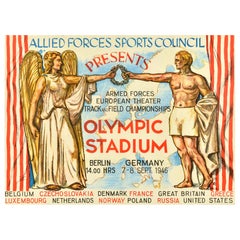
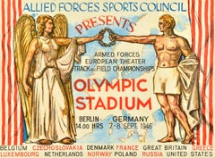
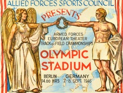
Original Vintage Military Poster Track And Field Allied Forces Sports Council
Located in London, GB
laurel wreath in front of a map of Europe between red and white striped theatre stage curtains with the
Paper


Harlem III
By Robert Cook
Located in New York, NY
1921. He studied with George Demetrios, a classical sculptor. During WWII he served in Europe as an
Bronze
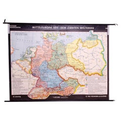
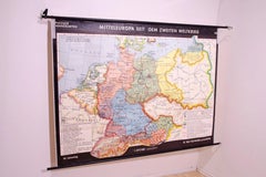
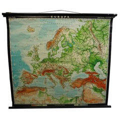
German Vintage school map of Central Europe, 1961
Located in Prague 8, CZ
Old Vintage school paper map of Central Europe. It was produced in 1961 in Germany. Map has on top
Wood, Paper
Unavailable
H 35.04 in W 43.71 in
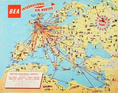
Original Vintage Poster BEA British European Airways International Air Route Map
Located in London, GB
Original vintage travel advertising poster for BEA British European Airways International Air
Paper

Unavailable
H 39.38 in W 25.6 in
Original Vintage Poster Sabena Belgian Airlines To Europe Asia Africa Travel Map
Located in London, GB
Original vintage pictorial travel map poster advertising Sabena Belgian Airlines flights to Europe
Paper
Unavailable
H 20.08 in W 28.35 in
Original Vintage Travel Poster Air France Planisphere Illustrated Map Boucher
By Lucien Boucher
Located in London, GB
the top, a detailed map of Europe with the tagline - on the wings of Air France discover the world on
Paper

Unavailable
H 25.6 in W 39.77 in
Original Vintage Travel Poster Air France World Map Postal Network Reseau Aerian
Located in London, GB
Original vintage Air France map poster - Air France Reseau Aerian Postal / Air France Postal
Paper

Unavailable
H 41.34 in W 29.93 in
Original Vintage WWII Poster Handen Weg! Europa Hands Off Europe War Netherlands
Located in London, GB
dramatic illustration depicting a giant hand grasping at the map of Europe defending itself with swords on
Paper
Unavailable
H 22.25 in W 30.12 in
Original Vintage Military Poster Track And Field Allied Forces Sports Council
Located in London, GB
laurel wreath in front of a map of Europe between red and white striped theatre stage curtains with the
Paper

Unavailable
H 0.04 in W 9.85 in D 14.57 in
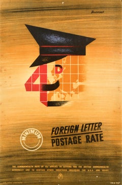
Original Vintage General Post Office Poster Foreign Letter Postage Rate GPO
Located in London, GB
, moustache and eye over a map of Europe and globe lines in the background, the text as a stamp and diagonally
Paper


Neil Young With Booker T. + The MG's Vintage 1993 Tour Tee Shirt
Located in Long Island City, NY
dates listed and a map of Europe of the back. Stated size L. Bust: 22.5" Bottom hem: 20.5 Shoulder
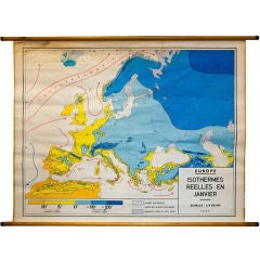
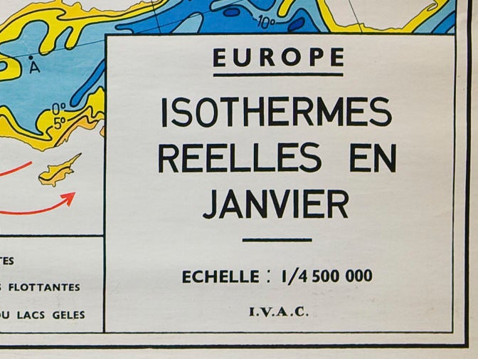
Vintage Belgian School Map of Isotherms across Europe in January
Located in Houston, TX
Map of winds and temperature in Europe in January. Came from a Belgian school house. Two
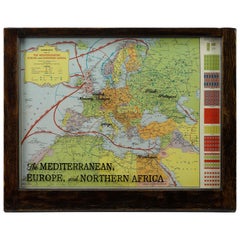
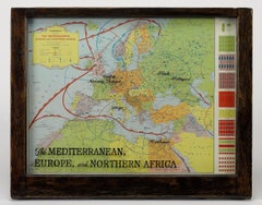
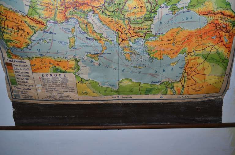
Hammond's Map of the Mediterranean, Europe, and Africa, circa 1941
Located in Colorado Springs, CO
This is an original WWII folding folio map of the Mediterranean, Europe, and Africa. The map was
Sold
H 50.2 in W 80.32 in D 0.6 in
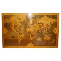
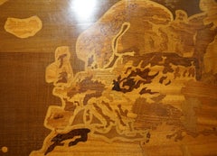
EXTRA LARGE 127CM X 204CM WORLD GLOBE MAP HAND CARVED AND INLAiD IN WOOD
Located in West Sussex, Pulborough
full sized 127cm x 204cm world map view in inlaid timber such as Oak, Walnut, Burr Walnut and Satinwood
Wood
Sold
H 68.51 in W 63 in D 0.4 in
Late 20th Century Educational Geographic Map - European Countries (1728.14)
Located in Hook, Hampshire
Late 20th Century Educational Geographic Map – European Countries (1728.14) Late 20th Century
Cotton
Sold
H 28.94 in W 38.98 in D 0.79 in
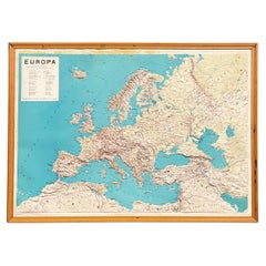
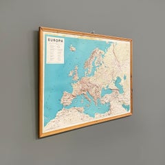
Italian modern Topographic geographical map in wood frame of Europe, 1950s-1990s
Located in MIlano, IT
Italian modern Topographic geographical map in wood frame of Europe, 1950-1990s Three-dimensional
Wood, Paper

Sold
H 62.21 in W 80.32 in D 0.79 in
Fantastic School Map Physical View of Europe Wall Chart Poster Print Decoration
Located in Berghuelen, DE
An impressive wall chart depicting a map of Europe. Used as teaching material in German schools
Canvas, Wood, Paper
Sold
H 18.12 in W 27.17 in D 0.04 in
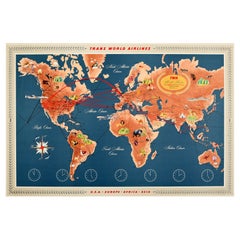
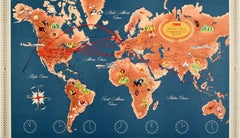
Original Vintage TWA Poster Trans World Airline Route Map Art Europe Africa Asia
Located in London, GB
Original vintage travel advertising map poster for TWA / Trans World Airlines USA Europe Africa
Paper
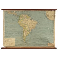
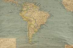
Early South American Educational Map from Italy, circa 1960
Located in Nashville, TN
Early South American educational map from Italy, circa 1960. Paper backed on canvas. Made in Milan
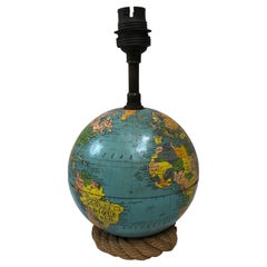

Rope Lamp World Map Audoux Minet Circa 1960
By Adrien Audoux and Frida Minnet
Located in Austin, TX
Small Midcentury rope lamp World map by Audoux Minet, circa 1960. Height without shade / 9 inches.
Metal

Picchiotti Pitti Building Map Metal and Bronze Rounded Wall Sculpture
By Picchiotti
Located in IT
Pitti Building in Florence (Italy) . It represents the map of Pitti Building. Diameter 180 cm / depth 20
Metal, Bronze
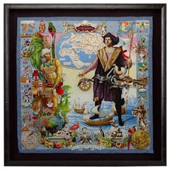
Hermès Silk Scarf, "Les Ameriques" by Kermit Oliver, 1992
Located in Colorado Springs, CO
, and the Santa Maria. An early European map is depicted in the top quarter of the composition featuring
Silk
Sold
H 20.08 in W 28.75 in D 0.04 in
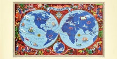
Original Vintage Air France Poster Illustrated Map World Travel Art Planisphere
By Lucien Boucher
Located in London, GB
the top, a detailed map of Europe with the tagline - on the wings of Air France discover the world on
Paper
Sold
H 29.53 in W 21.66 in D 0.04 in
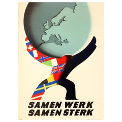
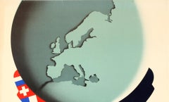
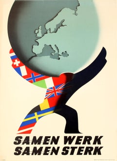
Original Vintage ERP Marshall Plan Poster - Europe Work Together Strong Together
Located in London, GB
map of Europe with chains linking the text together below. This design was submitted to the Intra
Paper
Sold
H 35.04 in W 23.23 in D 0.04 in
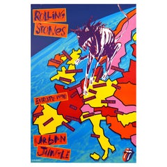
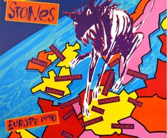
Original Vintage Music Concert Poster Rolling Stones Urban Jungle Europe Tour
Located in London, GB
colourful background marking the tour cities on a map of Europe with the iconic Rolling Stones tongue and
Paper


Sold
H 14.57 in W 9.85 in D 0.04 in
Original Vintage General Post Office Poster Foreign Letter Postage Rate GPO
Located in London, GB
, moustache and eye over a map of Europe and globe lines in the background, the text as a stamp and diagonally
Paper
Sold
H 24.02 in W 18.12 in D 0.04 in
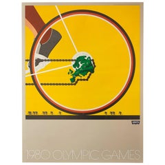
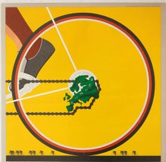
Set of 6 Original Vintage Posters 1980 Moscow Olympic Games Levi's Sport Design
Located in London, GB
features a close-up of the rear wheel of a racing bicycle with a map of Europe as the rear derailleur gear
Paper

Sold
H 26.78 in W 18.9 in D 0.04 in
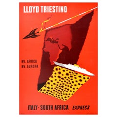
Original Vintage Cruise Travel Poster Lloyd Triestino Europa Italy South Africa
Located in London, GB
Express - featuring a dynamic design against a red background showing a map of Europe and Africa
Paper

Icarus
By Robert Cook
Located in New York, NY
with George Demetrios, a classical sculptor. During WWII he served in Europe as an engineer making
Bronze

Dinoceras #3
By Robert Cook
Located in New York, NY
1921. He studied with George Demetrios, a classical sculptor. During WWII he served in Europe as an
Stone, Bronze

Sold
H 16.63 in W 9 in D 15.13 in
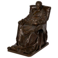
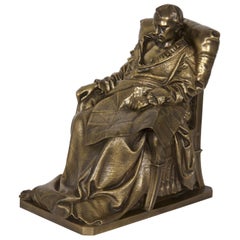
“Last Days of Napoleon” French Antique Bronze Sculpture by Vincenzo Vela
By F. Barbedienne Foundry, Vincenzo Vela 1
Located in Shippensburg, PA
. His right hand rests languidly on an arm of the chair his left nervously clutched rests on a map of
Bronze
Sold
H 38.19 in W 40.95 in D 0.79 in
Europe Map Vintage Rollable Mural Countrystyle Wall Chart Decoration
Located in Berghuelen, DE
The vintage pull-down map shows the European continent / Europe. Published by Haack-Painke, Justus
Canvas, Wood, Paper
Morphology school map of Europe
Located in bergen op zoom, NL
A huge morphology map of Europe, all levels in height morph out of the rubber map German quality
Rubber, Wood

1950s Economic European Pull Down School Map
Located in Tarrytown, NY
1950s economic European pull down school map.
Paper
Vintage Pull Down Map Wall Chart about Europe
Located in Berghuelen, DE
The wall map shows a map of Europe. It was published by Haack-Painke and Justus-Perthes-Darmstadt
Wood, Paper, Canvas
Vintage Poster Print European Rollable Map Wall Chart
Located in Berghuelen, DE
A classical pull-down map illustrating Europe, published by Klett-Perthes. used as teaching
Canvas, Wood, Paper

Sold
H 82.29 in W 87.8 in D 0.79 in
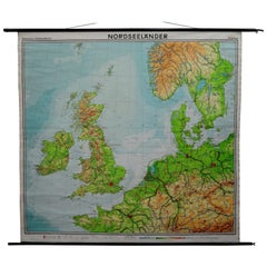
Vintage Pull Down Map North Sea Countries Northen Europe Great Britain Norway
Located in Berghuelen, DE
A classical school map showing the countries surrounding the North Sea (Great Britain, Ireland
Canvas, Wood, Paper
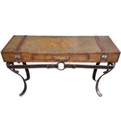
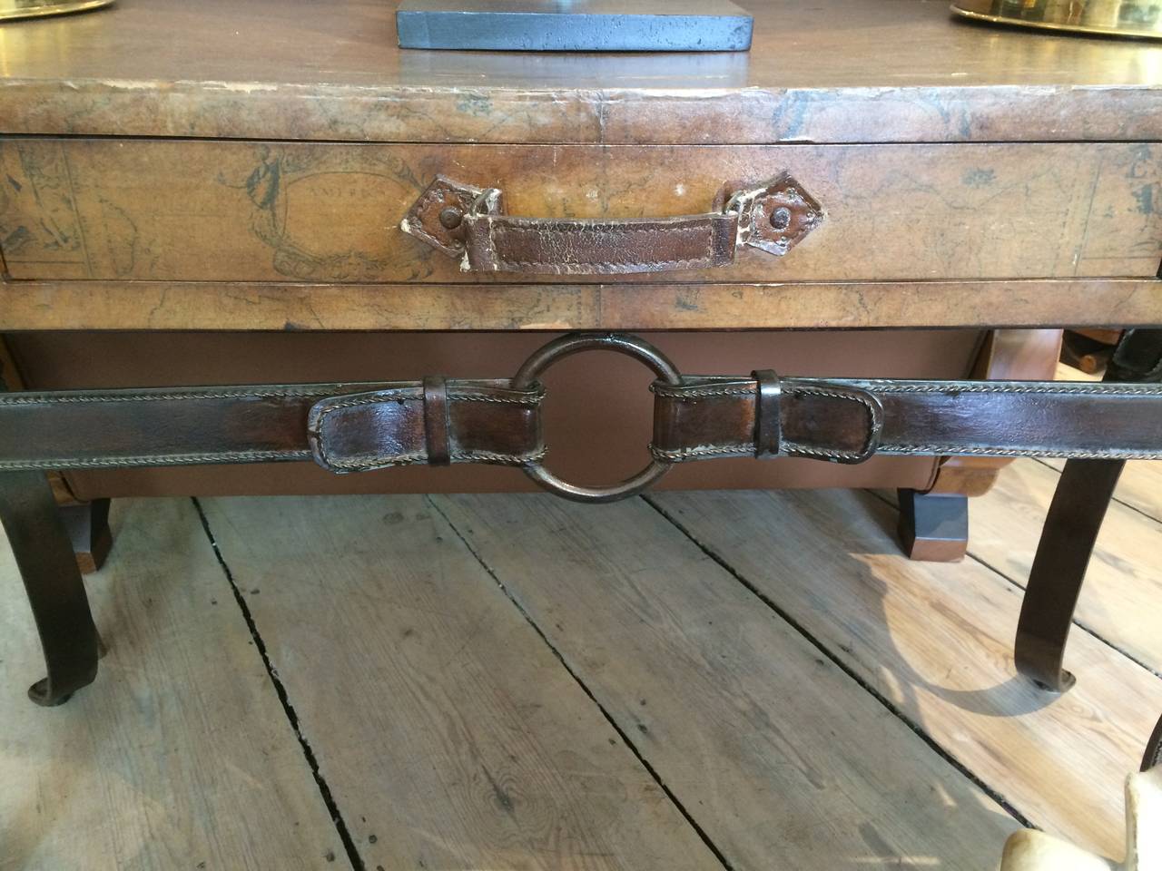
World Map Suitcase Table with Leather Straps and Buckles
Located in Nantucket, MA
This is a great find. A "suitcase' tabletop depicting a world map on top, with leather straps and
Iron
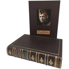

Crusade in Europe by Dwight D. Eisnehower, Signed First Trade Edition, 1948
Located in Colorado Springs, CO
numerous illustrations and maps, including four double-page color maps of the European theater and


Sold
H 1 in W 1 in D 1 in
Crusade in Europe by General Dwight D. Eisnehower, Signed First Edition, 1948
Located in Colorado Springs, CO
illustrations and maps, including four double-page color maps of the European theater and battlefields, signed

Sold
H 20.48 in W 14.18 in
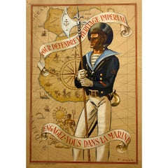
Circa 1940 Original Political poster - To defend the imperial heritage - Colony
Located in PARIS, FR
. It shows a sailor standing at attention, protecting a maritime map of southern Europe and Africa
Paper, Lithograph
Large Gold and Diamond Cufflinks Owned and Worn by Hollywood Icon Jerry Lewis
Located in Chicago, IL
diameter the cufflinks have a map of the European continent with cities marked with a Diamond, the
Diamond, 14k Gold


1993 Gianni Versace Men's 'Europa' Cartography Atelier Print Silk Button Shirt
By Gianni Versace
Located in West Hollywood, CA
, shoulders, and collar. This references the hand-colored printed maps of Europe in the Middle Ages, which

Sold
H 17 in W 11.5 in D 15.25 in
“Last Days of Napoleon” Antique French Bronze Sculpture by Vela & Barbedienne
By Vincenzo Vela 1, F. Barbedienne Foundry
Located in Shippensburg, PA
clutched rests on a map of Europe of 1814 spread on his lap, that Europe whose boundary lines he had so
Bronze


European Map of the winds in July
Located in Los Angeles, CA
Map of Europe detailing the wind patterns during the summer month of July.
Lithograph
Hand Painted Canvas map of Europe
Located in Los Angeles, CA
Hand painted European 1950's map. Map is 46" tall by 55" wide (wood bar top and bottom). The actual
Canvas
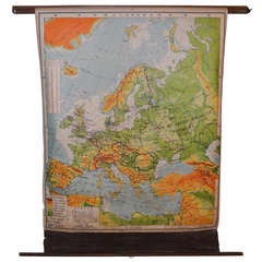
Post-war School Map of Europe, 1949 edition
Located in Madison, WI
Post-war classroom map of Europe, 1949 edition. Vividly colored by terrain, this map delineates the

Large Framed Schoolhouse Map
Located in Los Angeles, CA
Lovely faded Rand McNally School map of Europe, North Africa and the Middle East. Titled "The
Paper, Wood, Plexiglass
Sold
H 27.56 in W 44.49 in D 2.76 in
School Chart by Rudolf Dirr, Intersection, Paper on Linen, 1950s, Europe
By Rudolf Dirr
Located in Retie, BE
1950s school chart, school wall chart, roll up chart, teaching map Designed by Rudolf Dirr from
Linen, Wood, Paper
Map of Europe
Located in Los Angeles, CA
This antique map is rich in color and character. It is attached to two dowel rods, as it was
Lithograph

Vintage map of Europe
Located in Los Angeles, CA
Framed vintage map of Europe. Nice faded colors.
Wood, Glass

Map of Central Europe
Located in Los Angeles, CA
"Geologische Karte von Mitteleuropa" This detailed antique map is rich in color and
Lithograph


Map of Europe (In German)
Located in Los Angeles, CA
Map of Europe. Text in German.
Lithograph


School Chalk Map of Europe
Located in Los Angeles, CA
Printed out of Chicago, this map was found in Europe. Used in schools, you can still write on it
Sabena Map of Europe, Africa & Asia
Located in Los Angeles, CA
This map outlines the importance of Sabena as an aircraft with main coverage towards Africa
Lithograph, Paper

Africa by Sabena, Europe and Africa Map
Located in Los Angeles, CA
This map outlines the importance of Sabena as an aircraft with main coverage towards Africa
Lithograph, Paper

Europa Map - Horizontal
Located in West Hollywood, CA
Vintage map of Europe in Spanish. First Edition.
Wood

Sold
H 20.08 in W 28.75 in
Original Vintage Air France Poster Illustrated Map World Travel Art Planisphere
By Lucien Boucher
Located in London, GB
the top, a detailed map of Europe with the tagline - on the wings of Air France discover the world on
Paper

Sold
H 29.53 in W 21.66 in
Original Vintage ERP Marshall Plan Poster - Europe Work Together Strong Together
Located in London, GB
map of Europe with chains linking the text Together below. This design was submitted to the Intra
Paper